Wildcat Hills

Last updated
View from one of the stone shelters at Wildcat Hills State Recreation Area. Wildcat Hills-8Oct11.jpg
View from one of the stone shelters at Wildcat Hills State Recreation Area.

The Wildcat Hills are an escarpment between the North Platte River and Pumpkin Creek in the western Panhandle, in the state of Nebraska in the Great Plains region of the United States. Located in Banner, Morrill, and Scotts Bluff counties, the high tableland between the streams has been eroded by wind and water into a region of forested buttes, ridges and canyons that rise 150 to 300 m (490 to 980 ft) above the surrounding landscape.

Escarpment Steep slope or cliff separating two relatively level regions

An escarpment, or scarp, is a steep slope or long cliff that forms as an effect of faulting or erosion and separates two relatively level areas having differing elevations. Usually scarp and scarp face are used interchangeably with escarpment.

North Platte River major tributary of the Platte River

The North Platte River is a major tributary of the Platte River and is approximately 716 miles (1,152 km) long, counting its many curves. In a straight line, it travels about 550 miles (890 km), along its course through the U.S. states of Colorado, Wyoming, and Nebraska.

Pumpkin Creek is a stream in Morrill County, Knox County, and Banner County, Nebraska in the United States.

Contents

Chimney Rock, Scotts Bluff, and Courthouse and Jail Rocks are outcrops along the northern and western edges of the Wildcat Hills.

Chimney Rock National Historic Site historic site in Nebraska, United States

Chimney Rock is a prominent geological rock formation in Morrill County in western Nebraska. Rising nearly 300 feet (91 m) above the surrounding North Platte River valley, the peak of Chimney Rock is 4,228 feet (1,289 m) above sea level. The formation served as a landmark along the Oregon Trail, the California Trail, and the Mormon Trail during the mid-19th century. The trails ran along the north side of the rock, which remains a visible landmark for modern travelers along U.S. Route 26 and Nebraska Highway 92.

Scotts Bluff National Monument national monument in the United States

Scotts Bluff National Monument is located in the City of Gering in western Nebraska. This National Park Service site protects over 3,000 acres of historic overland trail remnants, mixed-grass prairie, rugged badlands, towering bluffs and riparian area along the North Platte River. The bluff served as an important landmark for pioneers on the Oregon Trail, California Trail, Mormon Trail and Pony Express Trail. The bluff is named after Hiram Scott, who was a clerk for William Ashley's Rocky Mountain Fur Company and died near the bluff in 1828. Over 250,000 westward emigrants passed by Scotts Bluff between 1843 and 1869. It was the second-most referred to landmark on the Oregon, California and Mormon trails in pioneer journals and diaries. Visitors to Scotts Bluff National Monument can walk in the footsteps of pioneers on remnants of the Oregon Trail, drive to the top of the bluff via the Summit Road, which is the oldest concrete road in the state of Nebraska and stand in awe at the sight of the bluffs raising from the prairie. The park boasts over 100,000 annual visitors.

Courthouse and Jail Rocks

Courthouse and Jail Rocks are two rock formations located near Bridgeport in the Nebraska Panhandle.

Ecology

The plant and animal life in the Wildcat Hills is atypical for Nebraska; the ecology resembles that of the Laramie Mountains, 60 miles to the west. The dominant tree in the region is the ponderosa pine. Bighorn sheep, pronghorn, elk, mule deer, and wild turkeys live in and around the hills.

Laramie Mountains

The Laramie Mountains are a range of moderately high peaks on the eastern edge of the Rocky Mountains in the U.S states of Wyoming and Colorado. The range is the northernmost extension of the line of the ranges along the eastern side of the Rockies, and in particular of the higher peaks of the Front Range directly to the south. North of the range, the gap between the Laramie range and the Bighorn Mountains provided the route for historical trails, such as the Oregon Trail, the Mormon Trail, and the Pony Express.

Bighorn sheep species of sheep native to North America

The bighorn sheep is a species of sheep native to North America. The species is named for its large horns. A pair of horns might weigh up to 14 kg (30 lb); the sheep weigh up to 140 kg (300 lb). Recent genetic testing indicates three distinct subspecies of Ovis canadensis, one of which is endangered: O. c. sierrae. Sheep originally crossed to North America over the Bering land bridge from Siberia; the population in North America peaked in the millions, and the bighorn sheep entered into the mythology of Native Americans. By 1900, the population had crashed to several thousand, due to diseases introduced through European livestock and overhunting.

Pronghorn species of mammal

The pronghorn is a species of artiodactyl mammal indigenous to interior western and central North America. Though not an antelope, it is often known colloquially in North America as the American antelope, prong buck, pronghorn antelope, prairie antelope, or simply antelope because it closely resembles the true antelopes of the Old World and fills a similar ecological niche due to parallel evolution.

Cougars (mountain lion), which had been eradicated from the region around 1900, returned to the area in the early 1990s. The Wildcat Hills (along with the Pine Ridge), are the only areas in Nebraska with a permanent population. [1]

Cougar Large cat of the family Felidae native to the Americas

The cougar, also commonly known by other names including catamount, mountain lion, panther, and puma, is a large felid of the subfamily Felinae native to the Americas. Its range, from the Canadian Yukon to the southern Andes of South America, is the widest of any large wild terrestrial mammal in the Western Hemisphere. An adaptable, generalist species, the cougar is found in most American habitat types. It is the biggest cat in North America, and the second-heaviest cat in the New World after the jaguar. Secretive and largely solitary by nature, the cougar is properly considered both nocturnal and crepuscular, although daytime sightings do occur. The cougar is more closely related to smaller felines, including the domestic cat, than to any species of subfamily Pantherinae, of which only the jaguar is native to the Americas.

Pine Ridge (region) region

The Pine Ridge is an escarpment between the Niobrara River and the White River in far northwestern Nebraska. The high tableland between the rivers has been eroded into a region of forested buttes, ridges and canyons.

History

Mitchell Pass looking east DSCN5188 mitchellpass e.jpg
Mitchell Pass looking east

The Emigrant Trail passed through the northern Wildcat Hills at Robidoux Pass and after 1851, at Mitchell Pass; the rock formations were frequently mentioned in emigrant journals and letters. The Nebraska Game and Parks Commission acquired land for the Wildcat Hills State Recreation Area 41°42′08″N103°40′02″W / 41.70222°N 103.66722°W / 41.70222; -103.66722 in stages between 1929 and 1980; the Wildcat Hills Nature Center, featuring a half-mile boardwalk trail, opened in 1995. Today, the Wildcat Hills are a popular hiking and wildlife viewing destination.

Robidoux Pass

Robidoux Pass, also known as Roubadeau Pass, Roubedeau Pass, Roubideau Pass, Roubidoux Pass and Roubadeau Pass Gap, is a gap passing through the Wildcat Hills near Scottsbluff, Nebraska about 9 miles (14 km) west of Gering, Nebraska. The gap was on the route of the historic Oregon or Emigrant Trail. It is at an elevation of 4,554 feet (1,388 m). Used by thousands of emigrants to the west from 1843-1851, the pass is a National Historic Landmark.

Mitchell Pass

Mitchell Pass is a gap through the Scotts Bluff ridge near Scottsbluff, Nebraska, and Gering, Nebraska. It is part of Scotts Bluff National Monument.

Nebraska Game and Parks Commission

The Nebraska Game and Parks Commission (NGPC) is the State of Nebraska's State agency charged with stewardship of the state's fish, wildlife, state park, and outdoor recreation resources. The agency is led by a governor-appointed member commission consisting of 9 commissioners which directs agency management. The commission is also charged with issuing of state hunting licenses, fishing licenses, and boat registrations. The agency also manages State Parks and recreation areas throughout the state. It conducts public education programs for hunting and boating safety. The agency is headquartered in Lincoln, Nebraska.

Related Research Articles

Scotts Bluff County, Nebraska County in the United States

Scotts Bluff County is a county on the western border of the U.S. state of Nebraska. As of the 2010 United States Census, the population was 36,970. Its county seat is Gering, and its largest city is Scottsbluff.

Gering, Nebraska City in Nebraska, United States

Gering is a city in Scotts Bluff County, Nebraska, United States. The population was 8,500 at the 2010 census. It is the county seat of Scotts Bluff County.

Scottsbluff, Nebraska City in Nebraska, United States

Scottsbluff is a city in Scotts Bluff County, in the western part of the state of Nebraska, in the Great Plains region of the United States. The population was 15,039 at the 2010 census. Scottsbluff is the largest city in the Nebraska Panhandle, and the 13th largest city in Nebraska.

Blue Ridge Parkway scenic parkway in the United States

The Blue Ridge Parkway is a National Parkway and All-American Road in the United States, noted for its scenic beauty. The parkway, which is America's longest linear park, runs for 469 miles (755 km) through 29 Virginia and North Carolina counties, linking Shenandoah National Park to Great Smoky Mountains National Park. It runs mostly along the spine of the Blue Ridge, a major mountain chain that is part of the Appalachian Mountains. Its southern terminus is at U.S. 441 on the boundary between Great Smoky Mountains National Park and the Cherokee Indian Reservation in North Carolina, from which it travels north to Shenandoah National Park in Virginia. The roadway continues through Shenandoah as Skyline Drive, a similar scenic road which is managed by a different National Park Service unit. Both Skyline Drive and the Virginia portion of the Blue Ridge Parkway are part of Virginia State Route 48, though this designation is not signed.

Mormon Trail emigrant route from Nauvoo, Illinois, to Salt Lake City, Utah, USA

The Mormon Trail is the 1,300-mile (2,092 km) route that members of The Church of Jesus Christ of Latter-day Saints traveled from 1846 to 1868. Today, the Mormon Trail is a part of the United States National Trails System, known as the Mormon Pioneer National Historic Trail.

American Discovery Trail long-distance hiking and biking trail across the United States

The American Discovery Trail is a system of recreational trails and roads which collectively form a coast-to-coast hiking and biking trail across the mid-tier of the United States. Horses can also be ridden on most of this trail. It starts on the Delmarva Peninsula on the Atlantic Ocean and ends on the northern California coast on the Pacific Ocean. The trail has northern and southern alternates for part of its distance, passing through Chicago and St Louis respectively. The total length of the trail including both the north and south routes is 6,800 miles (10,900 km). The northern route covers 4,834 miles (7,780 km) with the southern route covering 5,057 miles (8,138 km). It is the only non-motorized coast-to-coast trail.

Shawangunk Ridge

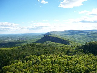
The Shawangunk Ridge, also known as the Shawangunk Mountains or The Gunks, is a ridge of bedrock in Ulster County, Sullivan County and Orange County in the state of New York, extending from the northernmost point of New Jersey to the Catskill Mountains. Shawangunk Ridge is the continuation of the long, easternmost ridge of the Appalachian Mountains; the ridge is known as Kittatinny Mountain in New Jersey, and as Blue Mountain as it continues through Pennsylvania. This ridge constitutes the western border of the Great Appalachian Valley.

Nebraska Panhandle

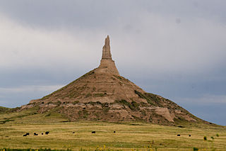
The Nebraska Panhandle is an area in the western part of the state of Nebraska and one of several U.S. state panhandles, or elongated geographical regions that extend from their main political entity.

Ponca State Park

Ponca State Park is a public recreation area located on the banks of the Missouri River four miles (6.4 km) north of Ponca, Nebraska, in the northeastern corner of the state. The state park's approximately 2,400 acres (970 ha) are situated among high bluffs and steep, forested hills adjacent to the Missouri National Recreational River. The park is managed by the Nebraska Game and Parks Commission.

Pine Ridge National Recreation Area

The Pine Ridge National Recreation Area is a United States National Recreation Area located in the Pine Ridge region of northwestern Nebraska. The recreation area is managed by the Pine Ridge Ranger District of the Nebraska National Forest.

Wildcat Mountain State Park

Wildcat Mountain State Park is a state park of Wisconsin, United States, on the Kickapoo River in the Driftless Area. Sandstone bluffs topped with limestone, two of which are Wildcat Mountain and Mount Pisgah, provide views over the narrow valley of the river and its tributaries. The Kickapoo Valley Reserve is immediately adjacent and forms a continuous protected area. Wildcat Mountain State Park is open for year-round recreation including hiking, canoeing, fishing, and cross-country skiing. The 3,643-acre (1,474 ha) park is located in Vernon County near the town of Ontario, Wisconsin.

Bradley Mountain mountain in United States of America

Bradley Mountain, 700 feet (210 m), is a traprock mountain located 3 miles (5 km) west of New Britain, Connecticut, United States, in the towns of Southington and Plainville. It is part of the narrow, linear Metacomet Ridge that extends from Long Island Sound near New Haven, Connecticut, north through the Connecticut River Valley of Massachusetts to the Vermont border. Bradley Mountain, popular as an outdoor recreation destination in the metropolitan Hartford/ New Britain area, is known for its clifftop scenic vistas overlooking Plainville Reservoir, unique microclimate ecosystems, and rare plant communities. Bradley Mountain is traversed by the 62.7-mile (101 km) Metacomet Trail.

West Rock Ridge State Park

West Rock Ridge State Park is a public recreation area located in New Haven, Hamden, and Woodbridge, Connecticut. The state park is named for the 400-to-700-foot trap rock West Rock Ridge, which is part of the Metacomet Ridge extending from Long Island Sound to the Vermont border. The park's 7 miles (11 km) of open west-facing cliffs offer vistas encompassing Metropolitan New Haven and suburban towns to the west. The park includes Judges Cave, a colonial era historic site; Lake Wintergreen; and the 7-mile (11 km) Regicides Trail, part of the Connecticut Forest and Park Association's Blue Trail system. The park is part of a larger area of protected open space including state, municipal, and non-profit owned land.

Platte River State Park

Platte River State Park is a public recreation area situated on the southern bluffs of the Platte River two miles (3.2 km) west of Louisville, Nebraska. The state park has a relatively steep, rolling topography compared to the surrounding region. The park consists of 519 acres (210 ha), much of it forested.

Tunxis Trail

The Tunxis Trail is a 79-mile (127 km) Blue-Blazed hiking trail "system" that traverses the western ridge of the central Connecticut Valley. The mainline trail is not completely contiguous, notably there are two gaps of several miles.

Raccoon Branch Wilderness

The Raccoon Branch Wilderness is an area in the Mount Rogers National Recreation Area protected by the Eastern Wilderness Act of Congress to maintain its present, natural condition. As part of the wilderness system, it is intended to preserve a variety of natural life forms and contribute to a diversity of plant and animal gene pools. Over half of the ecosystems in the United States exist within designated wilderness.

References