Thomas County, Nebraska

Last updated

Thomas County
Thomas County, Nebraska courthouse from SE.JPG
Thomas County courthouse in Thedford
Map of Nebraska highlighting Thomas County.svg
Location within the U.S. state of Nebraska
Nebraska in United States.svg
Nebraska's location within the U.S.
Coordinates: 41°55′N100°35′W / 41.92°N 100.58°W / 41.92; -100.58
CountryFlag of the United States.svg United States
StateFlag of Nebraska.svg  Nebraska
Founded1887
Named for George Henry Thomas
Seat Thedford
Largest villageThedford
Area
  Total714 sq mi (1,850 km2)
  Land713 sq mi (1,850 km2)
  Water0.8 sq mi (2 km2)  0.1%
Population
 (2020)
  Total669
  Density0.94/sq mi (0.36/km2)
Time zone UTC−6 (Central)
  Summer (DST) UTC−5 (CDT)
Congressional district 3rd

Thomas County is a county in the U.S. state of Nebraska. As of the 2020 United States Census, the population was 669. [1] Its county seat is Thedford. [2] The county was formed in 1887, and was named for General George H. Thomas. [3]

Contents

In the Nebraska license plate system, Thomas County is represented by the prefix 89 (it had the eighty-ninth-largest number of vehicles registered in the county when the license plate system was established in 1922).

Geography

A view of the Dismal River, Sandhills, and U.S. Route 83 in Thomas County Nebraska Sandhills.jpg
A view of the Dismal River, Sandhills, and U.S. Route 83 in Thomas County

The terrain of Thomas County consists of rolling hills, sloping to the east. The Middle Loup River flows east-southeastward through the middle of the county, and the Dismal River flows in the same direction through the lower part of the county. The two streams converge east of Thomas County. The county has an area of 714 square miles (1,850 km2), of which 713 square miles (1,850 km2) is land and 0.8 square miles (2.1 km2) (0.1%) is water. [4]

Major highways

Adjacent counties

National protected area

Demographics

Historical population
CensusPop.Note
1890 517
1900 62821.5%
1910 1,19189.6%
1920 1,77348.9%
1930 1,510−14.8%
1940 1,5532.8%
1950 1,206−22.3%
1960 1,078−10.6%
1970 954−11.5%
1980 9732.0%
1990 851−12.5%
2000 729−14.3%
2010 647−11.2%
2020 6693.4%
2022 (est.)6710.3%
US Decennial Census [5]
1790-1960 [6] 1900-1990 [7]
1990-2000 [8] 2010 [9] 2020 [10] 2022 [11]

As of the 2000 United States Census, [12] there were 729 people, 325 households, and 216 families in the county. The population density was 1 person per square mile (0.39 person/km2). There were 446 housing units at an average density of 0.6 units per square mile (0.23/km2). The racial makeup of the county was 99.45% White, 0.27% Native American, and 0.27% from two or more races. 0.82% of the population were Hispanic or Latino of any race.

There were 325 households, out of which 26.80% had children under the age of 18 living with them, 60.60% were married couples living together, 4.30% had a female householder with no husband present, and 33.50% were non-families. 31.40% of all households were made up of individuals, and 16.60% had someone living alone who was 65 years of age or older. The average household size was 2.24 and the average family size was 2.84.

The county population contained 23.60% under the age of 18, 4.40% from 18 to 24, 23.90% from 25 to 44, 27.80% from 45 to 64, and 20.30% who were 65 years of age or older. The median age was 44 years. For every 100 females there were 99.70 males. For every 100 females age 18 and over, there were 90.80 males.

The median income for a household in the county was $27,292, and the median income for a family was $36,618. Males had a median income of $25,662 versus $20,577 for females. The per capita income for the county was $15,335. About 13.60% of families and 14.30% of the population were below the poverty line, including 21.30% of those under age 18 and 17.30% of those age 65 or over.

Communities

Villages

Census-designated place

Unincorporated places

Politics

Thomas County voters are reliably Republican. In no national election since 1936 has the county selected the Democratic Party candidate.

Thomas county is the only county outside of the confederacy and border south to vote for both Democrat John Davis is in his landslide loss as well as Republican Barry Goldwater in his, 40 years later. [13]

United States presidential election results for Thomas County, Nebraska [14]
Year Republican Democratic Third party
No.%No.%No.%
2020 37788.29%4510.54%51.17%
2016 34487.53%307.63%194.83%
2012 36088.24%4210.29%61.47%
2008 33184.87%5113.08%82.05%
2004 37885.14%6013.51%61.35%
2000 32983.29%5513.92%112.78%
1996 30370.63%6414.92%6214.45%
1992 28360.34%7014.93%11624.73%
1988 38382.19%8117.38%20.43%
1984 29879.68%7319.52%30.80%
1980 30676.12%6516.17%317.71%
1976 34373.29%10322.01%224.70%
1972 39784.47%7315.53%00.00%
1968 35476.79%7616.49%316.72%
1964 31960.08%21239.92%00.00%
1960 42074.87%14125.13%00.00%
1956 42277.72%12122.28%00.00%
1952 49080.33%12019.67%00.00%
1948 31256.73%23843.27%00.00%
1944 33861.23%21438.77%00.00%
1940 48663.70%27736.30%00.00%
1936 36648.61%37449.67%131.73%
1932 26236.34%43760.61%223.05%
1928 40672.24%15227.05%40.71%
1924 20635.46%21637.18%15927.37%
1920 30555.86%20737.91%346.23%
1916 24445.78%26148.97%285.25%
1912 8622.28%17244.56%12833.16%
1908 9540.60%13055.56%93.85%
1904 8660.56%4028.17%1611.27%
1900 6543.62%8053.69%42.68%

See also

Related Research Articles

<span class="mw-page-title-main">Adams County, Nebraska</span> County in Nebraska, United States

Adams County is a county located in the U.S. state of Nebraska. As of the 2020 United States Census, the population was 31,205. Its county seat is Hastings. The county was formed in 1867 and organized in 1871. It is named for John Adams, the second President of the United States.

<span class="mw-page-title-main">Perkins County, Nebraska</span> County in Nebraska, United States

Perkins County is a county located in the U.S. state of Nebraska. As of the 2020 United States Census, the population was 2,858. Its county seat is Grant.

<span class="mw-page-title-main">McPherson County, Nebraska</span> County in Nebraska, United States

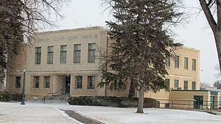
McPherson County is a county in the U.S. state of Nebraska. As of the 2020 Census, the population was 399, making it the least populous county in the state of Nebraska and the fifth-least populous county in the United States. Its county seat is Tryon. The county was formed in 1890 from Logan County; it was named for American Civil War General James B. McPherson.

<span class="mw-page-title-main">Logan County, Nebraska</span> County in Nebraska, United States

Logan County is a county in the U.S. state of Nebraska. As of the 2020 census, the population was 716. Its county seat is Stapleton.

<span class="mw-page-title-main">Kimball County, Nebraska</span> County in Nebraska, United States

Kimball County is a county in the U.S. state of Nebraska. As of the 2020 United States Census, the population was 3,434. Its county seat is Kimball. The county was formed in 1888 and named after railroad pioneer Thomas Lord Kimball.

<span class="mw-page-title-main">Johnson County, Nebraska</span> County in Nebraska, United States

Johnson County is a county in the U.S. state of Nebraska. As of the 2020 United States Census, the population was 5,290. Its county seat is Tecumseh. The county was formed in 1855, and was organized in 1857. It was named after Richard Mentor Johnson, who was Vice President of the United States from 1837 to 1841.

<span class="mw-page-title-main">Jefferson County, Nebraska</span> County in Nebraska, United States

Jefferson County is a county in the U.S. state of Nebraska. As of the 2020 United States Census, the population was 7,240. Its county seat is Fairbury. The county was named for Thomas Jefferson, third President of the United States of America.

<span class="mw-page-title-main">Hayes County, Nebraska</span> County in Nebraska, United States

Hayes County is a county in the U.S. state of Nebraska. As of the 2020 United States Census, the population was 856. Its county seat is Hayes Center. The county was created in 1877, and was organized in 1884. It was named for Rutherford B. Hayes, the US President at the time of the county's creation.

<span class="mw-page-title-main">Grant County, Nebraska</span> County in Nebraska, United States

Grant County is a county in the U.S. state of Nebraska. As of the 2020 United States Census, the population was 611, making it the fourth-least populous county in Nebraska and the ninth-least populous county in the United States. Its county seat is Hyannis. The county was founded in 1887 and named for Ulysses S. Grant, 18th President of the United States.

<span class="mw-page-title-main">Garfield County, Nebraska</span> County in Nebraska, United States

Garfield County is a county in the U.S. state of Nebraska. As of the 2020 United States Census, the population was 1,813. Its county seat is Burwell. The county was organized in 1884; it was named for James A. Garfield, 20th President of the United States.

<span class="mw-page-title-main">Franklin County, Nebraska</span> County in Nebraska, United States

Franklin County is a county in the U.S. state of Nebraska. As of the 2020 census, the population was 2,889. Its county seat is Franklin. The county was formed in 1867 and organized in 1871. It was named for Benjamin Franklin.

<span class="mw-page-title-main">Deuel County, Nebraska</span> County in Nebraska, United States

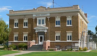
Deuel County is a county located in the U.S. State of Nebraska. As of the 2020 United States Census, the population was 1,838. Its county seat is Chappell. The county was formed in 1889 and named for Harry Porter Deuel, superintendent of the Union Pacific Railroad.

<span class="mw-page-title-main">Cuming County, Nebraska</span> County in Nebraska, United States

Cuming County is a county in the U.S. state of Nebraska. As of the 2020 United States Census, the population was 9,013. Its county seat is West Point.

<span class="mw-page-title-main">Brown County, Nebraska</span> County in Nebraska, United States

Brown County is a county in the U.S. state of Nebraska. As of the 2020 United States Census, the population was 2,903. Its county seat is Ainsworth. The county was established in 1883 and named for two members of the legislature who reported the bill for the county's organization.

<span class="mw-page-title-main">Boone County, Nebraska</span> County in Nebraska, United States

Boone County is a county in the U.S. state of Nebraska. As of the 2020 United States Census, the population was 5,386. Its county seat is Albion. The county was organized in 1871 and named after Daniel Boone.

<span class="mw-page-title-main">Blaine County, Nebraska</span> County in Nebraska, United States

Blaine County is a county in the U.S. state of Nebraska. As of the 2020 United States Census, the population was 431, making it Nebraska's second-least populous county and the sixth-least populous in the United States. Its county seat is Brewster. The county was formed in 1885 and organized in 1886. It is named after presidential candidate James G. Blaine.

<span class="mw-page-title-main">Arthur County, Nebraska</span> County in Nebraska, United States

Arthur County is a county located in the U.S. state of Nebraska. As of the 2020 United States Census, the population was 434, making it Nebraska's third least populous county and the seventh-least populous county in the United States. Its county seat and only incorporated community is Arthur.

<span class="mw-page-title-main">Sedgwick County, Colorado</span> County in Colorado, United States

Sedgwick County is a county located in the U.S. state of Colorado. As of the 2020 census, the population was 2,404. The county seat is Julesburg. The county was named for Fort Sedgwick, a military post along the Platte Trail, which was named for General John Sedgwick. It is located near the state border with Nebraska.

<span class="mw-page-title-main">Phillips County, Colorado</span> County in Colorado, United States

Phillips County is a county located in the U.S. state of Colorado. As of the 2020 census, the population was 4,530. The county seat is Holyoke. The county was named in honor of R.O. Phillips, a secretary of the Lincoln Land Company, who organized several towns in Colorado.

<span class="mw-page-title-main">Thedford, Nebraska</span> Village in and county seat of Thomas County Nebraska, United States

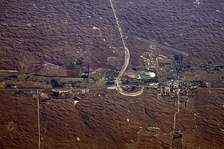
Thedford is a village and county seat of Thomas County, Nebraska, United States. The population was 208 at the 2020 census.

References

  1. "Thomas County, Nebraska". United States Census Bureau . Retrieved June 24, 2023.
  2. "Find a County". National Association of Counties. Retrieved June 7, 2011.
  3. "Thomas County". Archived from the original on July 16, 2011. Retrieved March 19, 2010. Retrieved on March 15, 2008.
  4. "2010 Census Gazetteer Files". US Census Bureau. August 22, 2012. Archived from the original on November 13, 2013. Retrieved December 12, 2014.
  5. "US Decennial Census". US Census Bureau. Retrieved December 12, 2014.
  6. "Historical Census Browser". University of Virginia Library. Retrieved December 12, 2014.
  7. "Population of Counties by Decennial Census: 1900 to 1990". US Census Bureau. Retrieved December 12, 2014.
  8. "Census 2000 PHC-T-4. Ranking Tables for Counties: 1990 and 2000" (PDF). US Census Bureau. Archived (PDF) from the original on March 27, 2010. Retrieved December 12, 2014.
  9. "QuickFacts: Thomas County, Nebraska". www.census.gov. United States Census Bureau. July 1, 2022. Retrieved June 4, 2023.
  10. "Thomas County, Nebraska". United States Census Bureau . Retrieved June 24, 2023.
  11. "State & County QuickFacts". US Census Bureau. Retrieved September 22, 2013.
  12. "U.S. Census website". US Census Bureau. Retrieved January 31, 2008.
  13. "The Political Graveyard: Thomas County, Neb". politicalgraveyard.com. Retrieved August 21, 2021.
  14. Election Results

41°55′N100°35′W / 41.92°N 100.58°W / 41.92; -100.58