Buffalo County, Nebraska

Last updated

Buffalo County
Buffalo County Courthouse (Nebraska) 3.jpg
Buffalo County Courthouse in Kearney
Map of Nebraska highlighting Buffalo County.svg
Location within the U.S. state of Nebraska
Nebraska in United States.svg
Nebraska's location within the U.S.
Coordinates: 40°52′N99°04′W / 40.86°N 99.07°W / 40.86; -99.07
CountryFlag of the United States.svg United States
StateFlag of Nebraska.svg  Nebraska
Founded1855 (authorized)
1870 (organized)
Named for American bison
Seat Kearney
Largest cityKearney
Area
  Total975 sq mi (2,530 km2)
  Land968 sq mi (2,510 km2)
  Water7.3 sq mi (19 km2)  0.7%
Population
 (2020)
  Total50,084
  Density51/sq mi (20/km2)
Time zone UTC−6 (Central)
  Summer (DST) UTC−5 (CDT)
Congressional district 3rd
Website www.buffalogov.org

Buffalo County is a county located in the U.S. state of Nebraska in the Midwestern United States. As of the 2020 United States Census, the population was 50,084, [1] making it Nebraska's fifth-most populous county. Its county seat is Kearney. [2] The county was created in 1855 [3] and was organized in 1870. [4] [5] It was named after the once-prevalent bison herds of the Great Plains. [6]

Contents

Buffalo County is part of the Kearney Micropolitan Statistical Area.

In the Nebraska license plate system, Buffalo County is represented by the prefix 9; when the license plate system was established in 1922, the county ranked ninth in number of registered vehicles.

History

The Union Pacific Railroad came to the area in 1866; [7] with additional settlers, the need to establish government was realized. Patrick Walsh, Martin Slattery, and a Sergeant Cody petitioned the governor to organize Buffalo County in 1869. [7] Wood River Centre (Shelton) was selected through election as county seat. Within a year, the seat was moved to Gibbon. [8] In 1874, voters selected Kearney as the seat. [9]

During the late 19th century and early 20th century, the Watson Ranch, existed in the county. The 8,000 acre ranch extended from the Platte River Valley on the south, to Nebraska's rolling hills on the north, to a point five miles west of downtown Kearney. [10] [11]

Geography

According to the US Census Bureau, the county has an area of 975 square miles (2,530 km2), of which 968 square miles (2,510 km2) is land and 7.3 square miles (19 km2) (0.7%) is water. [12]

Major highways

Transit

Protected area

Adjacent counties

Demographics

Historical population
CensusPop.Note
1860 114
1870 19369.3%
1880 7,5313,802.1%
1890 22,162194.3%
1900 20,254−8.6%
1910 21,9078.2%
1920 23,7878.6%
1930 24,3382.3%
1940 23,655−2.8%
1950 25,1346.3%
1960 26,2364.4%
1970 31,22219.0%
1980 34,79711.5%
1990 37,4477.6%
2000 42,25912.9%
2010 46,1029.1%
2020 50,0848.6%
2023 (est.)50,6971.2%
US Decennial Census [13]
1790-1960 [14] 1900-1990 [15]
1990-2000 [16] 2010 [17]

2020 Census

As of the 2020 United States Census, [18] there were 50,084 people in the county. The population density was 51 inhabitants per square mile (20/km2) . The racial makeup of the county was 85.5% White, 1.3% Black or African American, 0.8% Native American, 1.5% Asian, 0.2% Pacific Islander, and 1.7% from two or more races. 10.1% of the population were Hispanic or Latino of any race

2000 Census

As of the 2000 United States Census, [18] there were 42,259 people, 15,930 households, and 10,227 families in the county. The population density was 44 inhabitants per square mile (17/km2). There were 16,830 housing units at an average density of 17 units per square mile (6.6/km2). The racial makeup of the county was 95.18% White, 0.55% Black or African American, 0.33% Native American, 0.68% Asian, 0.03% Pacific Islander, 2.20% from other races, and 1.03% from two or more races. 4.66% of the population were Hispanic or Latino of any race. 42.5% were of German, 8.1% Irish, 7.8% English, 6.8% American and 5.3% Swedish ancestry.

There were 15,930 households, out of which 32.70% had children under the age of 18 living with them, 52.90% were married couples living together, 8.30% had a female householder with no husband present, and 35.80% were non-families. 26.10% of all households were made up of individuals, and 9.60% had someone living alone who was 65 years of age or older. The average household size was 2.48 and the average family size was 3.02.

The county population contained 25.00% under the age of 18, 17.80% from 18 to 24, 26.60% from 25 to 44, 19.00% from 45 to 64, and 11.50% who were 65 years of age or older. The median age was 30 years. For every 100 females, there were 96.00 males. For every 100 females age 18 and over, there were 92.40 males.

The median income for a household in the county was $36,782, and the median income for a family was $46,247. Males had a median income of $30,182 versus $21,977 for females. The per capita income for the county was $17,510. About 6.30% of families and 11.20% of the population were below the poverty line, including 10.50% of those under age 18 and 8.50% of those age 65 or over.

Communities

Map of Buffalo County Buffalo County4.png
Map of Buffalo County

Cities

Villages

Census-designated places

Unincorporated communities

Townships

Politics

Buffalo County voters have been strongly Republican for decades. Only seven Democratic Party presidential candidates have won the county from 1880 to the present day, the most recent of which being Lyndon B. Johnson in 1964.

United States presidential election results for Buffalo County, Nebraska [19]
Year Republican Democratic Third party
No.%No.%No.%
2020 16,64070.18%6,35026.78%7213.04%
2016 14,56968.95%4,76322.54%1,7978.50%
2012 13,57069.76%5,36527.58%5182.66%
2008 13,09767.88%5,86730.41%3291.71%
2004 14,22276.43%4,10022.03%2861.54%
2000 11,93172.48%3,92723.86%6033.66%
1996 10,00463.09%4,27726.97%1,5759.93%
1992 9,72655.11%3,74721.23%4,17623.66%
1988 9,98167.31%4,70231.71%1450.98%
1984 11,36578.11%3,08621.21%990.68%
1980 9,76968.59%3,16722.24%1,3079.18%
1976 8,09563.36%4,30833.72%3742.93%
1972 8,58774.19%2,98825.81%00.00%
1968 6,78665.29%2,87527.66%7337.05%
1964 5,42549.95%5,43650.05%00.00%
1960 7,59566.12%3,89133.88%00.00%
1956 7,34270.31%3,10029.69%00.00%
1952 8,46777.20%2,50122.80%00.00%
1948 4,86256.68%3,71643.32%00.00%
1944 6,07361.19%3,85238.81%00.00%
1940 6,38761.14%4,06038.86%00.00%
1936 4,59541.88%6,00254.70%3753.42%
1932 3,77338.02%5,87259.18%2782.80%
1928 7,46072.22%2,80127.12%680.66%
1924 4,74654.11%2,33726.64%1,68819.25%
1920 4,95465.56%2,25829.88%3454.57%
1916 2,21641.79%2,87754.25%2103.96%
1912 1,08122.93%2,06143.72%1,57233.35%
1908 2,52648.60%2,52048.49%1512.91%
1904 2,55462.07%73117.76%83020.17%
1900 1,91646.45%2,05649.84%1533.71%

See also

Related Research Articles

<span class="mw-page-title-main">Adams County, Nebraska</span> County in Nebraska, United States

Adams County is a county located in the U.S. state of Nebraska. As of the 2020 United States Census, the population was 31,205. Its county seat is Hastings. The county was formed in 1867 and organized in 1871. It is named for John Adams, the second President of the United States.

<span class="mw-page-title-main">North Platte, Nebraska</span> City in Nebraska, United States

North Platte is a city in and the county seat of Lincoln County, Nebraska, United States. It is located in the west-central part of the state, along Interstate 80, at the confluence of the North and South Platte Rivers forming the Platte River. The population was 23,390 at the 2020 census, making it the 11th most populous city in Nebraska.

<span class="mw-page-title-main">Webster County, Nebraska</span> County in Nebraska, United States

Webster County is a county in the U.S. state of Nebraska. As of the 2020 United States Census, the population was 3,411. Its county seat is Red Cloud. The county was formed in 1871, and was named for Daniel Webster.

<span class="mw-page-title-main">Valley County, Nebraska</span> County in Nebraska, United States

Valley County is a county in the U.S. state of Nebraska. As of the 2020 United States Census, the population was 4,059. Its county seat is Ord.

<span class="mw-page-title-main">Phelps County, Nebraska</span> County in Nebraska, United States

Phelps County is a county in the U.S. state of Nebraska. As of the 2020 United States Census, the population was 8,968. Its county seat is Holdrege. The county was formed in 1873, and was named for William Phelps (1808–1889), a steamboat captain and early settler.

<span class="mw-page-title-main">Kearney County, Nebraska</span> County in Nebraska, United States

Kearney County is a county located in the U.S. state of Nebraska. As of the 2020 United States Census, the population was 6,688. Its county seat is Minden. The county was formed in 1860. It was named for Fort Kearny, which in turn was named for Brigade General Stephen W. Kearny.

<span class="mw-page-title-main">Howard County, Nebraska</span> County in Nebraska, United States

Howard County is a county in the state of Nebraska. As of the 2020 United States Census, the population was 6,475. Its county seat is St. Paul. The county was formed in 1871 and named after Civil War General Oliver Otis Howard.

<span class="mw-page-title-main">Harlan County, Nebraska</span> County in Nebraska, United States

Harlan County is a county in the U.S. state of Nebraska. As of the 2020 United States Census, the population was 3,073. Its county seat is Alma. The county is home to the Harlan County Reservoir.

<span class="mw-page-title-main">Hall County, Nebraska</span> County in Nebraska, United States

Hall County is a county in the U.S. state of Nebraska. As of the 2020 United States Census, the population was 62,895, making it Nebraska's fourth-most populous county. Its county seat is Grand Island. The county was formed in 1858; it was named for Augustus Hall, an early judge of this territory.

<span class="mw-page-title-main">Franklin County, Nebraska</span> County in Nebraska, United States

Franklin County is a county in the U.S. state of Nebraska. As of the 2020 census, the population was 2,889. Its county seat is Franklin. The county was formed in 1867 and organized in 1871. It was named for Benjamin Franklin.

<span class="mw-page-title-main">Dawson County, Nebraska</span> County in Nebraska, United States

Dawson County is a county in the U.S. state of Nebraska. As of the 2020 United States Census, the population was 24,111. Its county seat is Lexington.

<span class="mw-page-title-main">Cherry County, Nebraska</span> County in Nebraska, United States

Cherry County is a county located in the U.S. state of Nebraska. As of the 2020 United States Census, the population was 5,455. Its county seat is Valentine. The county was named for Lt. Samuel A. Cherry, an Army officer who was stationed at Fort Niobrara and who had been killed in South Dakota in 1881. Cherry County is in the Nebraska Sandhills. It is the largest county in the state at nearly 6,000 square miles (16,000 km2), larger than the state of Connecticut.

<span class="mw-page-title-main">Elm Creek, Nebraska</span> Village in Nebraska, United States

Elm Creek is a village in Buffalo County, Nebraska, United States. It is part of the Kearney, Nebraska Micropolitan Statistical Area. The population was 979 at the 2020 census.

<span class="mw-page-title-main">Gibbon, Nebraska</span> City in Nebraska, United States

Gibbon is a city in Buffalo County, Nebraska, United States. It is part of the Kearney, Nebraska Micropolitan Statistical Area. The population was 1,833 at the 2010 census.

<span class="mw-page-title-main">Kearney, Nebraska</span> City in the United States

Kearney is the county seat of Buffalo County, Nebraska, United States. The population was 33,790 in the 2020 census, making it the 5th most populous city in Nebraska. It is home to the University of Nebraska at Kearney. The westward push of the railroad as the Civil War ended gave new birth to the community.

<span class="mw-page-title-main">Riverdale, Nebraska</span> Village in Nebraska, United States

Riverdale is a village in Buffalo County, in the state of Nebraska, in the Midwestern United States. It is part of the Kearney, Nebraska Micropolitan Statistical Area. The population was 182 at the 2010 census.

<span class="mw-page-title-main">Shelton, Nebraska</span> Village in Nebraska, United States

Shelton is a village in Buffalo and Hall counties, Nebraska, United States. It is part of the Kearney, Nebraska Micropolitan Statistical Area. The population was 1,059 at the 2010 census. It is located west of Grand Island along both the Union Pacific Railroad and U.S. Route 30. Nebraska Link 10-D connects Shelton with Interstate 80.

<span class="mw-page-title-main">Gothenburg, Nebraska</span> City in Nebraska, United States

Gothenburg is a city in Dawson County, Nebraska, United States. It is part of the Lexington, Nebraska Micropolitan Statistical Area. The population was 3,574 at the 2010 census.

<span class="mw-page-title-main">Minden, Nebraska</span> City in Nebraska, United States

Minden is a city in Kearney County, Nebraska, United States. The city serves as the county seat of Kearney County. The population was 3,118 at the 2020 census. It is home to the Pioneer Village museum complex of 28 buildings.

<span class="mw-page-title-main">Kimball, Nebraska</span> City in and county seat of Kimball County, Nebraska, United States

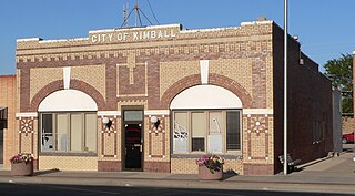
Kimball is a city in and county seat of Kimball County, Nebraska, United States. The population was 2,290 at the 2020 census.

References

  1. "Buffalo County, Nebraska". United States Census Bureau . Retrieved June 16, 2023.
  2. "Find a County". National Association of Counties. Archived from the original on May 31, 2011. Retrieved June 7, 2011.
  3. (March 10, 2009) Buffalo County says 1855 was the date, Kearney Hub , Retrieved November 10, 2010
  4. Andreas, A. T. (1882). "Andreas' History of the State of Nebraska". The Kansas Collection. Archived from the original on April 14, 2003. Retrieved December 13, 2014.
  5. "Buffalo County Nebraska Historic Buildings Survey" (PDF). Nebraska State Historical Society. August 1, 1993. Archived from the original on November 16, 2006. Retrieved December 13, 2014.{{cite web}}: CS1 maint: unfit URL (link)
  6. Fitzpatrick, Lillian L. (1960). Nebraska Place-Names. University of Nebraska Press. p. 24. ISBN   0803250606.
  7. 1 2 Bassett, Samuel Clay (1916). Buffalo County, Nebraska, and its people: a record of settlement, organization, progress and achievement, Vol. 1. Chicago: S. J. Clarke Pub. Co. pp. 145–161. OCLC   3358457.
  8. Duncan, Douglas. "Shelton - Buffalo County". Virtual Nebraska. Consortium for the Application of Space Data to Education (CASDE). Retrieved November 9, 2012.
  9. Bowman, J. R. (1882). Shearer, Frederick E. (ed.). The Pacific tourist. J.R. Bowman's illustrated transcontinental guide of travel from the Atlantic to the Pacific Ocean. New York: J.R. Bowman. p. 33. OCLC   752667534 . Retrieved May 13, 2018.
  10. Holmgren, Philip S. (October 1979). "THE WATSON RANCH - Part I". Buffalo County Historical Society. Retrieved April 20, 2020.
  11. "Watson, H. D., and the Watson Ranch". History Nebraska. Retrieved April 20, 2020.
  12. "2010 Census Gazetteer Files". US Census Bureau. August 22, 2012. Archived from the original on November 13, 2013. Retrieved December 6, 2014.
  13. "US Decennial Census". US Census Bureau. Retrieved December 6, 2014.
  14. "Historical Census Browser". University of Virginia Library. Retrieved December 6, 2014.
  15. "Population of Counties by Decennial Census: 1900 to 1990". US Census Bureau. Retrieved December 6, 2014.
  16. "Census 2000 PHC-T-4. Ranking Tables for Counties: 1990 and 2000" (PDF). US Census Bureau. Archived (PDF) from the original on March 27, 2010. Retrieved December 6, 2014.
  17. "State & County QuickFacts". US Census Bureau. Archived from the original on June 7, 2011. Retrieved September 17, 2013.
  18. 1 2 "U.S. Census website". US Census Bureau. Retrieved January 31, 2008.
  19. Election Results


40°52′N99°04′W / 40.86°N 99.07°W / 40.86; -99.07