Micronesian navigation

Last updated
The Austronesian peoples, who include the people of Micronesia, developed oceangoing sailing technologies to migrate across the Pacific Ocean. Oceania UN Geoscheme - Map of Micronesia.svg
The Austronesian peoples, who include the people of Micronesia, developed oceangoing sailing technologies to migrate across the Pacific Ocean.

Micronesian navigation techniques are those navigation skills used for thousands of years by the navigators who voyaged between the thousands of small islands in the western Pacific Ocean in the subregion of Oceania, that is commonly known as Micronesia. These voyagers used wayfinding techniques such as the navigation by the stars, and observations of birds, ocean swells, and wind patterns, and relied on a large body of knowledge from oral tradition. [1] [2] [3] These navigation techniques continued to be held by Polynesian navigators and navigators from the Santa Cruz Islands. [4] The re-creations of Polynesian voyaging in the late 20th century used traditional stellar navigational methods that had remained in everyday use in the Caroline Islands.

Contents

Early voyaging

Based on the current scientific consensus, the Micronesians are considered, by linguistic, archaeological, and human genetic evidence, to be a subset of the sea-migrating Austronesian people, who include the Polynesian people and the Melanesian people. Austronesians were the first people to invent oceangoing sailing technologies (notably double-hulled sailing canoes, outrigger boats, lashed-lug boat building, and the crab claw sail), which enabled their rapid dispersal into the islands of the Indo-Pacific. [5] [6] [7] From 2000 BCE they assimilated (or were assimilated by) the earlier populations on the islands in their migration pathway. [8] [9] [10] [11] [12]

The Mariana Islands were first settled around 1500 to 1400 BCE by migrants departing from the Philippines. This was followed by a second migration from the Caroline Islands during the first millennium CE, and a third migration from Island Southeast Asia (likely the Philippines or eastern Indonesia) by 900 CE. [13] [14] [15]

People from the Caroline Islands had regular contact with the Chamorro people of the Marianas Islands, as well as rarer voyages into the eastern islands of the Philippines. [16]

20th Century navigators

Navigator Mau Piailug (1932-2010) of Satawal island Mau Piailug.gif
Navigator Mau Piailug (1932–2010) of Satawal island

Mau Piailug was the best-known teacher of traditional, non-instrument wayfinding methods for open-ocean voyaging. He was a master navigator from the Carolinian island of Satawal. He earned the title of master navigator (palu) by the age of eighteen in 1950; which involved the sacred initiation ritual known as Pwo . As he neared middle age, he grew concerned that the practice of navigation in Satawal would disappear as his people became acculturated to Western values. In the hope that the navigational tradition would be preserved for future generations, Mau shared his knowledge with the Polynesian Voyaging Society (PVS). With Mau's help, PVS recreated and tested lost Hawaiian navigational techniques on the Hōkūle‘a , a modern reconstruction of a double-hulled Hawaiian voyaging canoe. [17] [18]

Hipour was a master navigator from the navigational school of Weriyeng and the island of Puluwat. [19] which greatly reinvigorated interest in traditional Pacific celestial navigation. In 1969, Hipour accompanied David Henry Lewis on his ketch Isbjorn from Puluwat in Chuuk to Saipan in the Northern Mariana Islands, and back, using traditional navigation techniques; a distance of approximately 1,000 km (621.37 mi) each way. [20] [21]

In April 1970, Repunglug and Repunglap, half-brothers, navigated from Satawal to Saipan in a traditional Carolinian outrigger canoe, which was approximately 26 feet (7.92 m) long, and equipped with a canvas sail. [21] This voyage was understood on Satawal to be the first time in the 20th century that a traditional canoe had made the voyage to Saipan. [21] While they used a small boat compass, they relied on their knowledge of traditional stellar navigation and wave patterns to sail approximately 52 miles (84 km) to West Fayu, where they waited for favourable winds before continuing on the 422 miles (679 km) voyage to Saipan. [21] They later made the return journey to Satawal. [21]

In the early 1970's there were at least 17 men who could serve as a master navigator (palu) for voyages to the Marianas. They include Sautan on Elato; Orupi, a Satawal man residing on Lamotrek; Ikegun, Epaimai, Repunglug, Repunglap, and Mau Piailug from Satawal; Ikuliman, Ikefie, Manipi, Rapwi, Faipiy, Faluta, Filewa and Hipour, all from Puluwat; Yaitiluk from Pulap, and Amanto from Tamatam. There were also six or seven apprentice navigators learning the art of traditional navigation on Satawal, including Epoumai and Repunglug's son Olakiman. [21] [4]

The Carolinian navigation system, used by Mau Piailug, relies on navigational clues using the Sun and stars, winds and clouds, seas and swells, observing the flight path of birds, and the patterns of bioluminescence that indicated the direction in which islands were located, [22] [23] which skills were acquired through rote learning passed down through teachings in the oral tradition. [24]

Once they had arrived fairly close to a destination island, the navigator would have been able to pinpoint its location by sightings of land-based birds, the cloud formations that form over islands, as well as the reflections of shallow water made on the undersides of clouds. Subtle differences in the colour of the sky also could be recognised as resulting from the presence of lagoons or shallow waters, as deep water was a poor reflector of light while the lighter colour of the water of lagoons and shallow waters could be identified in the reflection in the sky. [2]

These wayfinding navigation technique relies heavily on constant observation and memorization. Navigators have to memorize where they have sailed from in order to know where they are. The sun was the main guide for navigators because they could follow its exact points as it rose and set. Once the sun had set they would use the rising and setting points of the stars. When there were no stars because of a cloudy night or during daylight, a navigator would use the winds and swells as guides. [24] [23]

Star compass of Mau Piailug taught in the Caroline Islands, with North at top. Re-creation with shells on sand, with Satawalese (Chuukic) text labels, from the Polynesian Voyaging Society. See annotations on Commons. Mau-star-compass.png
Star compass of Mau Piailug taught in the Caroline Islands, with North at top. Re-creation with shells on sand, with Satawalese (Chuukic) text labels, from the Polynesian Voyaging Society. See annotations on Commons.

The positions of the stars helped guide voyages. Stars, as opposed to planets, hold fixed celestial positions year-round, changing only their rising time with the seasons. Each star has a specific declination, and can give a bearing for navigation as it rises or sets.

For navigators near the equator, (as navigators sailing between the islands of Micronesia), celestial navigation is simplified, given that the whole celestial sphere is exposed. Any star that passes through the zenith (overhead) moves along the celestial equator, the basis of the equatorial coordinate system. Voyagers would set a heading by a star near the horizon, switching to a new one once the first rose too high. A specific sequence of stars would be memorized for each route. [2] [3] [22]

Navigating by the stars requires knowledge of when particular stars, as they rotated through the night sky, would pass over the island to which the voyagers were sailing. The technique of "sailing down the latitude" was used. [2] [3] That is, knowledge that the movement of stars over different islands followed a similar pattern, (by recognising that different islands have a similar relationship to the night sky) provided the navigators with a sense of latitude, so that they could sail with the prevailing wind, before turning east or west to reach the island that was their destination. [1] [2]

Recording wave and swell formation in navigational devices

A navigational chart from the Marshall Islands, made of wood, sennit fiber and cowrie shells Micronesian navigational chart.jpg
A navigational chart from the Marshall Islands, made of wood, sennit fiber and cowrie shells
Stick chart in Uberseemuseum Bremen Uberseemuseum Bremen 2009 063a.jpg
Stick chart in Überseemuseum Bremen

Navigators could also observe the direction of the wave and swell formations to navigate caused by islands. Many of the habitable areas of the Pacific Ocean are groups of islands (or atolls) in chains hundreds of kilometres long. Island chains have predictable effects on waves and currents. Navigators who lived within a group of islands would learn the effect various islands had on the swell shape, direction, and motion, and would have been able to correct their path accordingly. Even when they arrived in the vicinity of an unfamiliar chain of islands, they may have been able to detect signs similar to those of their home. [2]

The energy transferred from the wind to the sea produces wind waves. The waves that are created when the energy travels down away from the source area (like ripples) are known as swell. When the winds are strong at the source area, the swell is larger. The longer the wind blows, the longer the swell lasts. Because the swells of the ocean can remain consistent for days, navigators relied on them to carry their canoe in a straight line from one house (or point) on the star compass to the opposite house of the same name. Navigators were not always able to see stars; because of this, they relied on the swells of the ocean. Swell patterns are a much more reliable method of navigation than waves, which are determined by the local winds. [2] [3] Swells move in a straight direction which makes it easier for the navigator to determine whether the canoe is heading in the correct direction. [26]

The people of the Marshall Islands have a history of using stick charts, to serve as spatial representations of islands and the conditions around them; with the curvature and meeting-points of the coconut ribs indicating the wave motion that was the result of islands standing in the path of the prevailing wind and the run of the waves. [2] [3] The charts represented major ocean swell patterns and the ways the islands disrupted those patterns, typically determined by sensing disruptions in ocean swells by islands during sea navigation. Most stick charts were made from the midribs of coconut fronds that were tied together to form an open framework. Island locations were represented by shells tied to the framework, or by the lashed junction of two or more sticks. The threads represented prevailing ocean surface wave-crests and directions they took as they approached islands and met other similar wave-crests formed by the ebb and flow of breakers. Individual charts varied so much in form and interpretation that the individual navigator who made the chart was the only person who could fully interpret and use it. [27] The use of stick charts ended after World War II when new electronic technologies made navigation more accessible and travel among islands by canoe lessened. [22]

Vessels

Sources

Related Research Articles

<span class="mw-page-title-main">Micronesia</span> Subregion of Oceania

Micronesia is a subregion of Oceania, consisting of about 2,000 small islands in the Northwestern Pacific Ocean. It has a close shared cultural history with three other island regions: Maritime Southeast Asia to the west, Polynesia to the east, and Melanesia to the south—as well as with the wider community of Austronesian peoples.

In Polynesian mythology, Hawaiki is the original home of the Polynesians, before dispersal across Polynesia. It also features as the underworld in many Māori stories.

<span class="mw-page-title-main">Polynesian Voyaging Society</span> Navigational society in Honolulu, Hawaii, United States

The Polynesian Voyaging Society (PVS) is a non-profit research and educational corporation based in Honolulu, Hawaiʻi. PVS was established to research and perpetuate traditional Polynesian voyaging methods. Using replicas of traditional double-hulled canoes, PVS undertakes voyages throughout Polynesia navigating without modern instruments.

<i>Hōkūleʻa</i> Polynesian double-hulled voyaging canoe

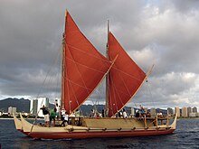
Hōkūleʻa is a performance-accurate waʻa kaulua, a Polynesian double-hulled voyaging canoe. Launched on 8 March 1975 by the Polynesian Voyaging Society, it is best known for its 1976 Hawaiʻi to Tahiti voyage completed with exclusively traditional navigation techniques. The primary goal of the voyage was to explore the anthropological theory of the Asiatic origin of native Oceanic people as the result of purposeful trips through the Pacific, as opposed to passive drifting on currents or sailing from the Americas. DNA analysis supports this theory. A secondary project goal was to have the canoe and voyage "serve as vehicles for the cultural revitalization of Hawaiians and other Polynesians."

The Micronesians or Micronesian peoples are various closely related ethnic groups native to Micronesia, a region of Oceania in the Pacific Ocean. They are a part of the Austronesian ethnolinguistic group, which has an Urheimat in Taiwan.

<span class="mw-page-title-main">Mau Piailug</span> Micronesian navigator (1932–2010)

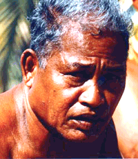
Pius "Mau" Piailug was a Micronesian navigator from the Carolinian island of Satawal, best known as a teacher of traditional, non-instrument wayfinding methods for open-ocean voyaging. Mau's Carolinian navigation system, which relies on navigational clues using the Sun and stars, winds and clouds, seas and swells, and birds and fish, was acquired through rote learning passed down through teachings in the oral tradition. He earned the title of master navigator (palu) by the age of eighteen, around the time the first American missionaries arrived in Satawal. As he neared middle age, Mau grew concerned that the practice of navigation in Satawal would disappear as his people became acculturated to Western values. In the hope that the navigational tradition would be preserved for future generations, Mau shared his knowledge with the Polynesian Voyaging Society (PVS). With Mau's help, PVS used experimental archaeology to recreate and test lost Hawaiian navigational techniques on the Hōkūleʻa, a modern reconstruction of a double-hulled Hawaiian voyaging canoe.

<span class="mw-page-title-main">Nainoa Thompson</span> Native Hawaiian navigator

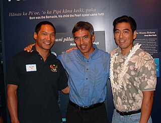
Charles Nainoa Thompson is a Native Hawaiian navigator and the president of the Polynesian Voyaging Society. He is best known as the first Hawaiian to practice the ancient Polynesian art of navigation since the 14th century, having navigated two double-hulled canoes from Hawaiʻi to other island nations in Polynesia without the aid of western instruments.

<span class="mw-page-title-main">Satawal</span> Atoll in Yap State, Federated States of Micronesia

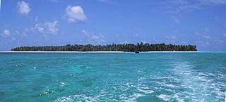
Satawal is a solitary coral atoll of one island with about 500 people on just over 1 km2 located in the Caroline Islands in the Pacific Ocean. It forms a legislative district in Yap State in the Federated States of Micronesia. Satawal is the easternmost island in the Yap island group and is located approximately 70 kilometers (43 mi) east of Lamotrek.

<span class="mw-page-title-main">Marshall Islands stick chart</span> Micronesian navigational aid

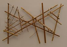
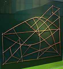
Stick charts were made and used by the Marshallese to navigate the Pacific Ocean by canoe off the coast of the Marshall Islands. The charts represented major ocean swell patterns and the ways the islands disrupted those patterns, typically determined by sensing disruptions in ocean swells by islanders during sea navigation.

David Henry Lewis was a sailor, adventurer, doctor, and scholar of Polynesian culture. He is best known for his studies on the traditional systems of navigation used by the Pacific Islanders. His studies, published in the book We, the Navigators, made these navigational methods known to a wide audience and helped to inspire a revival of traditional voyaging methods in the South Pacific.

Pwo is a sacred initiation ritual, in which students of traditional navigation in the Caroline Islands in Micronesia become navigators (palu) and are initiated in the associated secrets. Many islanders in the area indicate that this ceremony originated on the island of Pollap, or nearby islands.

Alingano Maisu, also known as Maisu, is a double-hulled voyaging canoe built in Kawaihae, Hawaii, by members of Na Kalai Waʻa Moku o Hawaiʻi and ʻOhana Wa'a members from throughout the Pacific and abroad as a gift and tribute to Satawalese navigator Mau Piailug, who navigated the voyaging canoe Hōkūleʻa on her maiden voyage to Tahiti in 1976 and has since trained numerous native Hawaiians in the ancient art of wayfinding. The word maisu comes from the Satawalese word for breadfruit that has been knocked down by storm winds and is therefore available for anyone to take. The name is said to symbolize the knowledge of navigation that is made freely available.

<span class="mw-page-title-main">Polynesian navigation</span> Methods to navigate the Pacific Ocean

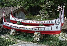
Polynesian navigation or Polynesian wayfinding was used for thousands of years to enable long voyages across thousands of kilometres of the open Pacific Ocean. Polynesians made contact with nearly every island within the vast Polynesian Triangle, using outrigger canoes or double-hulled canoes. The double-hulled canoes were two large hulls, equal in length, and lashed side by side. The space between the paralleled canoes allowed for storage of food, hunting materials, and nets when embarking on long voyages. Polynesian navigators used wayfinding techniques such as the navigation by the stars, and observations of birds, ocean swells, and wind patterns, and relied on a large body of knowledge from oral tradition. This island hopping was a solution to the scarcity of useful resources, such as food, wood, water, and available land, on the small islands in the Pacific Ocean. When an island’s required resources for human survival began to run low, the island's inhabitants used their maritime navigation skills and set sail for new islands. However, as an increasing number of islands in the South Pacific became occupied, and citizenship and national borders became of international importance, this was no longer possible. People thus became trapped on islands with the inability to support them.

<span class="mw-page-title-main">Polynesia</span> Subregion of Oceania

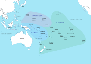
Polynesia is a subregion of Oceania, made up of more than 1,000 islands scattered over the central and southern Pacific Ocean. The indigenous people who inhabit the islands of Polynesia are called Polynesians. They have many things in common, including language relatedness, cultural practices, and traditional beliefs. In centuries past, they had a strong shared tradition of sailing and using stars to navigate at night.

Satawalese is a Micronesian language of the Federated States of Micronesia. It is nearly mutually intelligible with Mortlockese and Carolinian.

<i>Wa</i> (watercraft) Type of outrigger canoe from the Caroline Islands

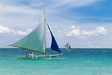
Wa are traditional sailing outrigger canoes of the Caroline Islands, Palau, and Yap. They have a single outrigger. They are similar to the sakman of the Northern Marianas.

Hipour was a master navigator from the navigational school of Weriyeng and the island of Puluwat.

We, the Navigators, The Ancient Art of Landfinding in the Pacific is a 1972 book by the British-born New Zealand doctor David Lewis, which explains the principles of Micronesian and Polynesian navigation through his experience of placing his boat under control of several traditional navigators on long ocean voyages.

<span class="mw-page-title-main">Sakman</span>

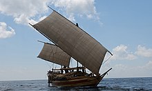
Sakman, better known in western sources as flying proas, are traditional sailing outrigger boats of the Chamorro people of the Northern Marianas. They are characterized by a single outrigger and a crab claw sail. They are the largest native sailing ships (ladjak) of the Chamorro people. Followed by the slightly smaller lelek and the medium-sized duding. They are similar to other traditional sailing ships of Micronesia, like the wa, baurua, and the walap. These ships were once used for trade and transportation between islands.

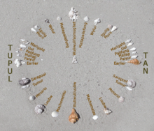
etak is a word of Micronesian origin for a distinctive cognitive and mnemonic approach to oceanic navigation and orientation involving a notional reference point or "island", called etak, and triangulation based on it. The system under that name was found in the Caroline Islands, and the literal meaning of etak is "refuge". Alfred Gell described it as a way of encoding dead reckoning applied to sea journeys. It is an example of a dynamic cognitive map.

References

  1. 1 2 Holmes, Lowell Don (1 June 1955). "Island Migrations (1): The Polynesian Navigators Followed a Unique Plan". XXV(11) Pacific Islands Monthly. Archived from the original on 1 October 2021. Retrieved 1 October 2021.
  2. 1 2 3 4 5 6 7 8 Holmes, Lowell Don (1 August 1955). "Island Migrations (2): Birds and Sea Currents Aided Canoe Navigators". XXVI(1) Pacific Islands Monthly. Archived from the original on 1 October 2021. Retrieved 1 October 2021.
  3. 1 2 3 4 5 Holmes, Lowell Don (1 September 1955). "Island Migrations (3): Navigation was an Exact Science for Leaders". XXVI(2) Pacific Islands Monthly. Archived from the original on 1 October 2021. Retrieved 1 October 2021.
  4. 1 2 Lewis, David (1974). "Wind, Wave, Star, and Bird". National Geographic. 146 (6): 747–754, 771–778.
  5. Doran, Edwin B. (1981). Wangka: Austronesian Canoe Origins. Texas A&M University Press. ISBN   9780890961070.
  6. Dierking, Gary (2007). Building Outrigger Sailing Canoes: Modern Construction Methods for Three Fast, Beautiful Boats. International Marine/McGraw-Hill. ISBN   9780071594561.
  7. Horridge, Adrian (1986). "The Evolution of Pacific Canoe Rigs". The Journal of Pacific History. 21 (2): 83–89. doi:10.1080/00223348608572530. JSTOR   25168892.
  8. Bellwood, Peter (1988). "A Hypothesis for Austronesian Origins" (PDF). Asian Perspectives. 26 (1): 107–117. Archived (PDF) from the original on 1 May 2019. Retrieved 1 May 2019.
  9. Bellwood, Peter (1991). "The Austronesian Dispersal and the Origin of Languages". Scientific American. 265 (1): 88–93. Bibcode:1991SciAm.265a..88B. doi:10.1038/scientificamerican0791-88. JSTOR   24936983.
  10. Hill, Adrian V.S.; Serjeantson, Susan W., eds. (1989). The Colonization of the Pacific: A Genetic Trail. Research Monographs on Human Population Biology No. 7. Oxford University Press. ISBN   9780198576952.
  11. Bellwood P, Fox JJ, Tryon D (2006). The Austronesians: Historical and Comparative Perspectives. Australian National University Press. ISBN   9781920942854. Archived from the original on 2 April 2020. Retrieved 23 March 2019.
  12. Blench, Roger (2012). "Almost Everything You Believed about the Austronesians Isn't True" (PDF). In Tjoa-Bonatz, Mai Lin; Reinecke, Andreas; Bonatz, Dominik (eds.). Crossing Borders. National University of Singapore Press. pp. 128–148. ISBN   9789971696429. Archived (PDF) from the original on 30 December 2019. Retrieved 23 March 2019.
  13. Hung, Hsiao-chun; Carson, Mike T.; Bellwood, Peter; Campos, Fredeliza Z.; Piper, Philip J.; Dizon, Eusebio; Bolunia, Mary Jane Louise A.; Oxenham, Marc; Chi, Zhang (2015). "The first settlement of Remote Oceania: the Philippines to the Marianas". Antiquity. 85 (329): 909–926. doi: 10.1017/S0003598X00068393 .
  14. Zotomayor, Alexie Villegas (March 12, 2013). "Archaeologists say migration to Marianas longest ocean-crossing in human history". Marianas Variety News and Views: 2. Archived from the original on October 21, 2022. Retrieved October 25, 2020.
  15. Zotomayor, Alexie (March 11, 2013). "Archaeologist says migration to Marianas longest ocean-crossing in human history". Marianas Variety. Archived from the original on March 16, 2017. Retrieved December 29, 2014.
  16. Peterson, John A. (2012). "Latte villages in Guam and the Marianas: Monumentality or monumenterity?" (PDF). Micronesica. 42 (1/2): 183–208. Archived (PDF) from the original on 2019-04-12. Retrieved 2021-10-04.
  17. Lewis, David (1978). The Voyaging Stars: Secrets of the Pacific Island Navigators. William Collins Publishers Pty Ltd, Sydney. ISBN   0-393-03226-4.
  18. Finney, Ben (1994). Voyage of Rediscovery: A Cultural Odyssey through Polynesia. Illustrations by Richard Rhodes. University of California Press. ISBN   0-520-08002-5.
  19. Gladwin, Thomas (1970). East Is a Big Bird; Navigation & Logic on Puluwat Atoll. Cambridge Massachusetts: Harvard University Press. ISBN   0-674-22425-6.
  20. Lewis, David (1974). "Wind, Wave, Star, and Bird". National Geographic. 146 (6): 771–778.
  21. 1 2 3 4 5 6 Michael McCoy (1973). "A Renaissance in Carolinian-Marianas Voyaging". Journal of the Polynesian Society, Auckland University. Archived from the original on 2021-12-28. Retrieved 2021-10-07.
  22. 1 2 3 Lewis, David (1972). We, the Navigators. HI: University of Hawaii Press. ISBN   9780824802295.
  23. 1 2 Lewis, David (1974). "Wind, Wave, Star, and Bird". National Geographic. 146 (6): 747–754, 771–778.
  24. 1 2 Thompson, Nainoa. "On Wayfinding". Polynesian Voyaging Society. Archived from the original on November 2, 2017. Retrieved April 11, 2018.
  25. "Star Compasses". Polynesian Voyaging Society. Archived from the original on 24 October 2011.
  26. Gooley, Tristan (2016). How to Read Water: Clues, Signs & Patterns from Puddles to the Sea. NY: Hodder & Stoughton. ISBN   9781473615205.
  27. Finney, Ben (1998). "13: Nautical Cartography and Traditional Navigation in Oceania" (PDF). In Woodward, David; Lewis, G. Malcolm (eds.). The History of Cartography. Vol. 2.3: Cartography in the Traditional African, American, Arctic, Australian, and Pacific Societies. p. 476. Archived (PDF) from the original on 2021-10-04. Retrieved 2021-10-04.