Midvale, Utah

Last updated

Midvale, Utah
7900 S State St.jpg
southbound just past 7800 South in Midvale
Salt Lake County Utah incorporated and unincorporated areas Midvale highlighted.svg
Location in Salt Lake County and the state of Utah.
Coordinates: 40°36′50″N111°53′18″W / 40.61389°N 111.88833°W / 40.61389; -111.88833
CountryUnited States
State Utah
County Salt Lake
Area
[1]
  Total5.91 sq mi (15.32 km2)
  Land5.91 sq mi (15.32 km2)
  Water0.00 sq mi (0.00 km2)
Elevation
[2]
4,383 ft (1,336 m)
Population
 (2010)
  Total27,964
  Estimate 
(2019)
34,124
  Density5,770.04/sq mi (2,227.74/km2)
Time zone UTC−7 (Mountain (MST))
  Summer (DST) UTC−6 (MDT)
ZIP code
84047
Area code(s) 385, 801
FIPS code 49-49710 [3]
GNIS feature ID1430307 [2]
Website www.midvalecity.org

Midvale is a city in Salt Lake County, Utah, United States. It is part of the Salt Lake City metropolitan area. Midvale's population was 34,124 according to 2019 estimates from the U.S. Census Bureau. [4]

Contents

Midvale is home to the Shops at Fort Union, located on the East side of the city and the Bingham Junction economic center, located on the west side of the city. Midvale is centrally located in the most populous county in Utah and is bisected by Interstate 15. Interstate 215 serves as the northern boundary of the city's east side. Midvale is one of the few cities in Utah to be home to two direct TRAX lines and three TRAX stations.

Geography

According to the United States Census Bureau, the city has a total area of 5.8 square miles (15.1 km2), all land. The western border of Midvale is the Jordan River that flows down the center of the valley.

Climate

This climatic region is typified by large seasonal temperature differences, with warm to hot summers and cold winters. According to the Köppen Climate Classification system, Midvale has a humid continental climate, abbreviated "Dfb" on climate maps. [5]

Under the Köppen climate classification, Sandy has a humid subtropical climate (Cfa) or a humid continental climate (Dfa) depending on which variant of the system is used.

Climate data for Midvale, Utah
MonthJanFebMarAprMayJunJulAugSepOctNovDecYear
Record high °F (°C)64
(18)
70
(21)
80
(27)
87
(31)
107
(42)
110
(43)
108
(42)
107
(42)
100
(38)
92
(33)
78
(26)
66
(19)
108
(42)
Average high °F (°C)38
(3)
44
(7)
53
(12)
64
(18)
73
(23)
84
(29)
93
(34)
91
(33)
81
(27)
67
(19)
51
(11)
41
(5)
65
(18)
Average low °F (°C)17
(−8)
23
(−5)
29
(−2)
36
(2)
43
(6)
50
(10)
58
(14)
57
(14)
47
(8)
37
(3)
27
(−3)
21
(−6)
37
(3)
Record low °F (°C)−25
(−32)
−19
(−28)
−4
(−20)
11
(−12)
22
(−6)
30
(−1)
35
(2)
36
(2)
18
(−8)
10
(−12)
−16
(−27)
−22
(−30)
−25
(−32)
Average precipitation inches (mm)1.2
(30)
1.3
(33)
1.6
(41)
1.8
(46)
1.4
(36)
0.9
(23)
0.7
(18)
1
(25)
.8
(20)
1.4
(36)
1.3
(33)
1.4
(36)
14.7
(370)
Source: weather.com [6]

Demographics

Historical population
CensusPop.Note
1910 1,760
1920 2,20925.5%
1930 2,45111.0%
1940 2,87517.3%
1950 3,99639.0%
1960 5,80245.2%
1970 7,84035.1%
1980 10,14629.4%
1990 11,88617.1%
2000 27,029127.4%
2010 27,9643.5%
2020 36,02828.8%
U.S. Decennial Census [7]

According to the US Census Bureau, it is estimated that Midvale is home to 33,636 people. It is estimated that the population identifies as: 76.9% non-Hispanic White, 23.6% Hispanic or Latino, 4.3% Hawaiian or other Pacific Islander, 3.4% Black or African American, and 0.4% American Indian.

It is estimated that Midvale is home to 12,412 households with an owner occupancy rate of 43.3%. The median price of a home in 2018 was estimated at $241,200 whereas the 2020 projection for the median house price has climbed to $338,000 in less than two years.

It is estimated that 64.5% of Midvale's population is between the ages of 18 and 65. With 27% of the population below 18 and 8.5% above 65. It is also estimated that 49.7% of Midvale is female.

Law and government

Midvale City has a nonpartisan mayor-council form of government. The Mayor and five Council members are elected to four-year terms. The current mayor of Midvale is Marcus Stevenson. Current City Council members include Quinn Sperry, Paul Glover, Heidi Robinson, Bryant Brown, and Dustin Gettel. [8]

Midvale Fire and Police are furnished by arrangement with the Unified Police and Fire of Salt Lake County. Consequently, Midvale no longer fields its own police or fire departments. The current head of the Unified Police Department Midvale Precinct is Police Chief Randy Thomas and the Unified Fire Department is headed by Chief Dominic Burchett.

Education

Jordan School District was the primary school district in Midvale until 2009. In 2007, citizens voted to split Jordan School District to create 2 separate school districts - Jordan School District and the newly created Canyons School District. The Canyons School District is now the primary school district located in Midvale. It began operation at the beginning of the 2009–10 school year.

Midvale has 4 elementary schools (Copperview Elementary, East Midvale Elementary, Midvale Elementary, and Midvalley Elementary), two middle schools (Midvale Middle School and Union Middle School), and one High School (Hillcrest High School).

Media

The Midvale City Journal is a monthly newspaper delivered to homes in Midvale City. The Journal covers local stories in Sports, Education, City Council, and Local Life.

Some scenes from the mini-series The Stand as well as scenes from the movies Halloween 4: The Return of Michael Myers , Gentlemen Broncos , and The Sandlot , were filmed in downtown Midvale, including the interior of an old-fashioned drugstore by the name of Vincent Drug.[ citation needed ] The store stayed in business and retained products in packaging over 50 years old for this type of display purpose. Vincent Drug shut down in 2003.

History

Located in the central part of the Salt Lake Valley, and next to the Jordan River, Midvale was an early target for settlers in Utah. Permanent homes began as early as the 1850s, with one of the earliest homes still preserved today. The population grew quickly in the 1870s thanks to its central location, the use of railroad, and its connection to the mining in Bingham Canyon, the western area of present-day Midvale became an important industrial area for Utah. To support this growth, the eastern area of present-day Midvale provided agriculture and housing.

Incorporation

People in the area, presumably, started calling the area Midvale, due to its central location in the valley. In 1909 Midvale officially became a city and in the 1910 census had a population of 1,760. [9]

Growth

Fort Union Area

Fort Union, historically Union, was an early settlement area on the eastern edge of present-day Midvale. When Midvale annexed the Fort Union Area, it brought an established housing population. However, it did not just provide the city with a much larger population base, it also brought the city the shops of Fort Union. The shops provide both shopping and office space for Midvale.

Bingham Junction Area

Bingham Junction, originally known as the Sharon Steel site, is on the western border of Midvale and is roughly 446 acres in size. The area originally started seeing economic development as early as 1871 as a slag site for mining, which operated as such until 1958. Upon testing, it appeared to have large amounts of lead, arsenic and heavy metals, rendering the property unusable. Through mediation, help from the EPA and other parties, the area underwent a major cleanup and restoration project that saw its name removed from the NPL in 2006. [10]

Since Bingham Junction's removal from the NPL, the area underwent major changes. It brought about thousands of new households to the city. In connection with the added residential, major corporations moved to the area, where Overstock, CHG, and Savage now use as their headquarters. Also other major companies have brought their operation to the area, including Marriott, Zagg and IHC. Entertainment followed with the first ever Top Golf in Utah resides in the Bingham Junction area. As other important shopping centers such as Winco and other dining options. The EPA now considers this a success story and estimates as of 2018 there are 56 on site businesses with at least 2,646 employees.

Bingham Junction is also home to a stop on the red line, that goes from the western edges of Salt Lake County to the University of Utah, Utah's flagship university.

Jordan Bluffs Area

Following in the success of the Bingham Junction Area, the area known as Jordan Bluffs is beginning the early phase of similar redevelopment. Jordan Bluffs is situated south of Bingham Junction and was originally part of the Sharon Steel slag site. It compromises 351 acres in the south west region of Midvale. [11]

Jordan Bluffs is in the beginning phases of redevelopment, but current proposals could see an additional 3,500 housing units and over 1,000,000 square feet of office space within the next ten years. [12]

Transportation

Roadways

Bus stands at Midvale Center station, Jan 15.jpg

Midvale operates under a grid system as the rest of Salt Lake County. However, as most cities originally operated under their own grid system, Midvale City was one of the last to transition to the county. [13] I-15 runs down the center of Midvale, with I-215's interchange with I-15 meeting in the 7200 and state region in Midvale.

Bus

The Utah Transit Authority (UTA) operates a bus system that reaches into the city including a sky service bus route. Bus routes serve nearby light rail stations, multiple commercial districts (including the Shops at Fort Union and the State Street commercial district), office parks, and government offices. The ski bus route operates along the 7200 south corridor. [14]

Rail

UTA's TRAX light rail system operates two separate rail line routes in Midvale, serving both the Red Line and Blue Line. The city is home to three light rail stations: The Red Line has Bingham Junction, and the Blue Line has Midvale Fort Union and Midvale Center stations.

Economy

CHG Healthcare Services, Arctic Circle Restaurants, Veritas Funding, LLC, Sportmans' Warehouse, Zagg and Overstock.com are headquartered in Midvale.

School Improvement Network, an education consulting company, moved its national headquarters to Midvale in 2011.

Notable people

Related Research Articles

<span class="mw-page-title-main">Salt Lake County, Utah</span> County in Utah, United States

Salt Lake County is located in the U.S. state of Utah. As of the 2020 United States census, the population was 1,185,238, making it the most populous county in Utah. Its county seat and largest city is Salt Lake City, the state capital. The county was created in 1850. Salt Lake County is the 37th most populated county in the United States and is one of four counties in the Rocky Mountains to make it into the top 100. Salt Lake County has been the only county of the first class in Utah – under the Utah Code is a county with a population of 700,000 or greater. Although, Utah County directly to the south has recently reached this threshold.

<span class="mw-page-title-main">Bluffdale, Utah</span> City in Utah, United States

Bluffdale is a city in Salt Lake and Utah counties in the U.S. state of Utah, located about 20 miles (32 km) south of Salt Lake City. As of the 2020 census, the city population was 17,014.

<span class="mw-page-title-main">Cottonwood Heights, Utah</span> City in the United States

Cottonwood Heights is a city located in Salt Lake County, Utah, United States, along the east bench of the Salt Lake Valley. It lies south of the cities of Holladay and Murray, east of Midvale, and north of Sandy within the Salt Lake City, Utah Metropolitan Statistical Area. Originally a census-designated place (CDP), following a successful referendum in May 2004, the city was incorporated on January 14, 2005. The population, as of the 2020 census, was 33,617.

<span class="mw-page-title-main">Murray, Utah</span> City in Utah, United States

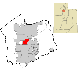
Murray is a city situated on the Wasatch Front in the core of Salt Lake Valley in the U.S. state of Utah. Named for territorial governor Eli Murray, it is the state's fourteenth largest city. According to the 2020 census, Murray had a population of 50,637. Murray shares borders with Taylorsville, Holladay, South Salt Lake and West Jordan, Utah. Once teeming with heavy industry, Murray's industrial sector now has little trace and has been replaced by major mercantile sectors. Known for its central location in Salt Lake County, Murray has been called the Hub of Salt Lake County. Unlike most of its neighboring communities, Murray operates its own police, fire, power, water, library, and parks and recreation departments and has its own school district. While maintaining many of its own services, Murray has one of the lowest city tax rates in the state.

<span class="mw-page-title-main">Riverton, Utah</span> City in Utah, United States

Riverton is a city in Salt Lake County, Utah, United States. It is part of the Salt Lake City, Utah Metropolitan Statistical Area. The population was 45,285 as of the 2020 census. Riverton is located in the rapidly growing southwestern corner of the Salt Lake Valley.

<span class="mw-page-title-main">Sandy, Utah</span> City in Salt Lake County, Utah, United States

Sandy is a city in the Salt Lake City metropolitan area, located in Salt Lake County, Utah, United States. The population of Sandy was 87,461 at the 2010 census, making it the sixth-largest city in Utah. The population is currently estimated to be about 96,380 according to the July 1, 2019 United States Census estimates.

<span class="mw-page-title-main">South Jordan, Utah</span> City in Salt Lake County, Utah, United States

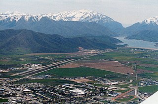
South Jordan is a city in south central Salt Lake County, Utah, United States, 18 miles (29 km) south of Salt Lake City. Part of the Salt Lake City metropolitan area, the city lies in the Salt Lake Valley along the banks of the Jordan River between the 10,000-foot (3,000 m) Oquirrh Mountains and the 11,000-foot (3,400 m) Wasatch Mountains. The city has 3.5 miles (5.6 km) of the Jordan River Parkway that contains fishing ponds, trails, parks, and natural habitats. The Salt Lake County fair grounds and equestrian park, 67-acre (27 ha) Oquirrh Lake, and 37 public parks are located inside the city. As of 2020, there were 77,487 people in South Jordan.

<span class="mw-page-title-main">Taylorsville, Utah</span> City in Utah, United States

Taylorsville is a city in Salt Lake County, Utah. It is part of the Salt Lake City metropolitan area. The population was 60,448 at the time of the 2020 census. Taylorsville was incorporated from the Taylorsville–Bennion CDP and portions of the Kearns metro township on July 1, 1996. The city is located adjacent to Interstate 215 and Bangerter Highway. It is located in the middle of the Salt Lake Valley.

<span class="mw-page-title-main">West Jordan, Utah</span> City in Utah, United States

West Jordan is a city in Salt Lake County, Utah, United States. It is a suburb of Salt Lake City. According to the 2020 Census, the city had a population of 116,961, placing it as the third most populous in the state. The city occupies the southwest end of the Salt Lake Valley at an elevation of 4,330 feet (1,320 m). Named after the nearby Jordan River, the limits of the city begin on the river's western bank and end in the eastern foothills of the Oquirrh Mountains, where Kennecott Copper Mine, the world's largest man-made excavation, is located.

<span class="mw-page-title-main">Heber City, Utah</span> City in Utah, United States

Heber City is a city and county seat of Wasatch County, Utah. The population was 16,856 as of the 2020 United States census. The city is located 43 miles southeast of Salt Lake City.

<span class="mw-page-title-main">Hildale, Utah</span> City in Utah, United States

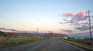
Hildale is a city in Washington County, Utah, United States. The population was 1,127 at the 2020 census.

<span class="mw-page-title-main">Draper, Utah</span> City in Utah, United States

Draper is a city in Salt Lake and Utah counties in the U.S. state of Utah, about 20 miles (32 km) south of Salt Lake City along the Wasatch Front. As of the 2020 census, the population is 51,017, up from 7,143 in 1990.

<span class="mw-page-title-main">Jordan River (Utah)</span> River feeding the Great Salt Lake, USA

The Jordan River, in the state of Utah, United States, is a river about 51 miles (82 km) long. Regulated by pumps at its headwaters at Utah Lake, it flows northward through the Salt Lake Valley and empties into the Great Salt Lake. Four of Utah's six largest cities border the river: Salt Lake City, West Valley City, West Jordan, and Sandy. More than a million people live in the Jordan Subbasin, part of the Jordan River watershed that lies within Salt Lake and Utah counties. During the Pleistocene, the area was part of Lake Bonneville.

<span class="mw-page-title-main">Blue Line (TRAX)</span> Light rail line in Salt Lake City, Utah, USA

The Blue Line is a light rail line on the TRAX system in the Salt Lake Valley of Utah, in the United States, operated by the Utah Transit Authority (UTA). It is the first line of the TRAX system completed. The line opened on December 4, 1999, one year ahead of schedule after two years of construction. In addition to Salt Lake City, it also serves the communities of South Salt Lake, Murray, Midvale, Sandy and Draper. The line was known as the North/South Line or the Sandy/Salt Lake Line until color names were adopted for each TRAX line in August 2011. An extension of the line to Draper began service on August 18, 2013.

<span class="mw-page-title-main">Red Line (TRAX)</span> Light rail line in Salt Lake City, Utah, USA

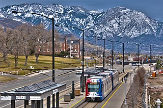
The Red Line is a light rail line on the TRAX system in the Salt Lake Valley of Utah operated by the Utah Transit Authority (UTA). It originally began operation in December 2001 as the peak-hour-only Sandy/University Line, running from the University of Utah south to Sandy Civic Center on the Blue Line. It was later rerouted to South Jordan and renamed the Red Line in August 2011, running as an all-day route. The current line runs from the University of Utah Medical Center in Salt Lake City through the south end of Downtown Salt Lake City, South Salt Lake, Murray, Midvale, West Jordan, and South Jordan to the University of Utah's South Jordan Medical Center in Daybreak.

Canyons School District is a school district in the southeastern portion of Salt Lake County in Utah, United States. The district includes the cities of Cottonwood Heights, the Salt Lake County section of Draper, Midvale and Sandy and the townships of Alta, Brighton and White City. Residents of those communities voted to create the district in 2007, making Canyons the first school district to be formed in the state in almost a century. Canyons has approximately 34,000 students in 50 schools. There are 29 elementary schools, eight middle schools, five traditional high schools, and eight special programs schools, including one technical school, a special education school and a high school for adults in prison. The district covers 192 square miles and employs 6,000 people.

<span class="mw-page-title-main">Bingham Junction station</span>

Bingham Junction station is a light rail station in Midvale, Utah, United States, served by the Red Line of the Utah Transit Authority's (UTA) TRAX light rail system. The Red Line provides service from the University of Utah to the Daybreak community of South Jordan.

<span class="mw-page-title-main">Fort Union (Utah)</span> Commercial area in Utah, United States

Fort Union, historically Union, is a major commercial area and an early settlement in the Salt Lake Valley of Utah that is now split between the municipalities of Midvale, Cottonwood Heights, and Sandy. The fort after which the area was named was built early (1853) in the Salt Lake Valley's post-1847 history at a strategic point where escarpments on either side of the Little Cottonwood Creek valley create a narrow gateway to the upper valley and Little Cottonwood Canyon beyond. The effects of geography on travel through the area have also contributed to the area's much more recent success as a retail and employment destination.

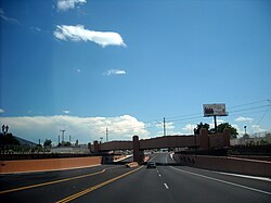
State Street is a wide 17.3-mile-long (27.8 km) street in Salt Lake County, Utah leading almost straight south from the steps of the Utah State Capitol Building, through Salt Lake City, South Salt Lake, Millcreek, Murray, eastern Midvale, Sandy, and northwestern Draper. Because it follows the most direct route from downtown Salt Lake City to the Point of the Mountain pass to Utah County, it was the undisputed main road south from Salt Lake City until Interstate 15 (I-15) was built to the west. It retains the U.S. Highway 89 designation for all but the northernmost seven blocks despite I-15's proximity. Due to its history as a route for long-distance travel, travel within the Wasatch Front region, and travel between the cities along the east side of the Jordan River, it has attracted a wide variety of retail and service businesses along its entire length, creating a nearly continuous commercial axis for the Salt Lake Valley.

The state of Utah has an increasingly diverse population, home to hundreds of thousands of Hispanic/Latino people who share ancestry from Latin American countries. It is estimated that there are roughly 383,400 residents of Hispanic/Latino descent currently living in Utah.

References

  1. "2019 U.S. Gazetteer Files". United States Census Bureau. Retrieved August 7, 2020.
  2. 1 2 U.S. Geological Survey Geographic Names Information System: Midvale, Utah
  3. "U.S. Census website". United States Census Bureau . Retrieved January 31, 2008.
  4. "U.S. Census Bureau QuickFacts". U.S. Census Bureau. Retrieved December 17, 2018.
  5. "Midvale, Utah Köppen Climate Classification (Weatherbase)". Weatherbase. Retrieved February 14, 2021.
  6. "Midvale, Utah Travel Weather Averages (Weatherbase)". Weatherbase. Retrieved February 14, 2021.
  7. "Census of Population and Housing". Census.gov. Retrieved June 4, 2015.
  8. "Midvale City Council | Midvale, UT". www.midvalecity.org. Retrieved February 14, 2021.
  9. "The History of Midvale, Utah(Midvale, Utah) - Utah". www.garply.com. Archived from the original on February 26, 2017. Retrieved August 14, 2020.
  10. Nielson-Stowell, Amelia (August 29, 2006). "After 23 years, Midvale Slag site is clean". Deseret News. Retrieved August 14, 2020.
  11. "Jordan Bluff expansion, traffic woes and transparency discussed in meeting | Midvale Journal". www.midvalejournal.com. Retrieved August 14, 2020.
  12. "Zions Bank to build new tech campus on former Sharon Steel mill site in Midvale". The Salt Lake Tribune. Retrieved August 14, 2020.
  13. Swensen, Jason (February 16, 1999). "Midvale addresses to change April 15 City will adopt street numbers of S.L. County grid system". Deseret News. Retrieved August 14, 2020.
  14. "Mountain Corridor and Tourism | Midvale, UT". www.midvalecity.org. Retrieved August 14, 2020.