Salt Lake County is located in the U.S. state of Utah. As of the 2020 United States census, the population was 1,185,238,[1] making it the most populous county in Utah. Its county seat and largest city is Salt Lake City, the state capital.[2] The county was created in 1850.[3] Salt Lake County is the 37th most populated county in the United States and is one of four counties in the Rocky Mountains to make it into the top 100. (Others being Denver County and El Paso County, Colorado and Clark County, Nevada.) Salt Lake County has been the only county of the first class in Utah – under the Utah Code (Title 17, Chapter 50, Part 5) is a county with a population of 700,000 or greater.[4] Although, Utah County directly to the south has recently reached this threshold. [5]
This area was occupied for thousands of years by cultures of indigenous peoples.
19th century
The future Salt Lake County area was settled by European Americans in 1847 when Mormon pioneers of the Church of Jesus Christ of Latter-day Saints fled religious persecution in the East. They arrived in the Salt Lake Valley after descending what settlers later called Emigration Canyon. Brigham Young, their leader, declared "This is the place" after seeing the valley. Compared to eastern regions, it seemed arid and unpromising to some of the migrants. Settlers used irrigation to develop agriculture and the flourishing, self-sufficient city known then as Great Salt Lake City. Thousands of Mormons joined them in the next several decades.
Settlers buried thirty-six Native Americans in one grave after an outbreak of measles occurred during the winter of 1847.[8]
The initial territorial settlement was in Great Salt Lake City proper, but Brigham Young desired to secure a substantial population base across the then-uninhabited Great Basin, so he soon asked members to resettle farther out from the central point. They declared themselves a state (State of Deseret) in hopes of gaining admittance to the Union, and to assure the nascent state would grow uniformly, they named an as-yet-unbuilt settlement in mid-state as the state's capital (Fillmore).
The county was officially organized on January 31, 1850, with slightly more than 11,000 residents recorded.[8] In 1850, 26 slaves were counted in Salt Lake County.[8] In 1852, the territorial legislature passed the Act in Relation to Service and the Act for the relief of Indian Slaves and Prisoners formally legalizing slavery in the territory.
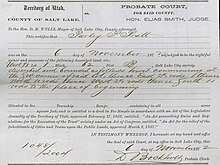
Parley P. Pratt's Land Title Certificate, No. 1048, 1872
Due to Utah Territory's conflicts with the federal government, the federal surveyor abandoned his post in 1857, two years after he arrived. The surveyor's duty was to officially plat the territory in order to bring the area onto the market, to make homesteading possible.[9] The intermediate years between 1857 and 1869 passed with no federal surveyors, the LDS Pioneers completed plats, deeds, and surveys of the county in order to homestead and collect taxes. Since the deeds and titles handed out during the twelve-year period were not federally recognized homestead certificates,[10] the Utah Territory agreed to reconcile the unrecognized deeds and titles in order to fold the Utah Territory into the federal homestead system, calling them (instead of homestead certificates) Land Title Certificates. The process to adjudicate the certificates took place over several years in 1871–1873, through the county Probate Court, overseen by judge Elias Smith.[11] Settlers were required to file land claims, make declaratory statements, attend their adjudication hearings, provide testimony if counter claims on a parcel of land were filed, and wait for final judgement from the probate judge, who issued a final Land Title Certificate which declared a person the rightful owner. These certificates are retroactive backwards to 1852.
The idea of statehood for the new area was quickly tossed aside by the federal government, and the area was declared a territory in September 1850 – the Utah Territory. Construction of the capitol building in Fillmore was completed in 1855, so the territorial legislature traveled to the small community for their first session there. It was to be their last, as they chose to meet in Great Salt Lake City the following year and, in 1857, formally voted to make the city the capital of the Territory. In 1858, when the Utah Territory was declared in rebellion, the federal government sent troops to install a new governor and keep watch over the area. The government transition was made peacefully, then the troops set up Camp Floyd to the south in Utah County. In 1862, Fort Douglas was established on the eastern bench, near the current site of the University of Utah, as the federal government wanted to ensure the loyalty of the territory during the American Civil War. On January 29, 1868, "Great" was dropped from both the county and city names, giving them their modern names.[12]
Patrick Edward Connor, the leader of the garrison at Fort Douglas, was openly anti-Mormon. He sent out parties to scout for mineral resources in the nearby mountains, hoping to encourage non-Mormons to settle in the territory. During the late 19th century, mines were established in the Wasatch mountains, most notably around Alta (and nearby Park City in Summit County). Exploiting the mineral wealth was difficult until the Utah Central Railroad was constructed and reached this area in 1870.
In the Oquirrh Mountains, the Bingham Canyon Mine, which contains vast deposits of copper and silver, was developed as the most productive of the county's mines. The mine, located in the southwest portion of the county, attracted thousands of workers to the narrow canyon. At its peak, the city of Bingham Canyon contained 20,000 residents, all crowded along the steep walls of the canyon, and natural disasters were a frequent occurrence. By the early 20th century, most of the mines in the county had closed. However, the Bingham Canyon Mine kept on expanding. In the early 21st century, it is among the largest open-pit mines in the world.
20th century
After the railroad came to the county, the population began to expand more rapidly, and non-Mormons began to settle in Salt Lake City. During the early 20th century, the heavy industry came to the valley as well, diversifying its economy. Local and interurban trolley systems were built covering the more urban northeastern quarter of the valley. The city dismantled the trolley system by 1945, favoring the use of individual cars. Throughout the late 19th and early 20th centuries, the east side of the valley began to be more densely settled.
In 1942, Kearns Army Air Base, a large military installation developed for World War II, was located in what is now Kearns on the western side of the valley. After the camp was closed in 1946, the land was sold for private development. Rapid postwar residential settlement of the area began. The federal government established other major defensive installations along the Wasatch Front and in the Great Salt Lake Desert during World War II, which stimulated the economy and brought more people to the area, establishing Utah as a major military center that benefited from federal investment. In the nationwide suburban boom of the late 1940s, 1950s, and early 1960s, such cities as South Salt Lake, Murray, Midvale, and much of the east side of the valley grew rapidly.
In common with other industrialized cities, Salt Lake City faced inner-city decay in the 1960s, when residents moved to newer housing in the suburbs. Cities such as Sandy, West Jordan, and what would become West Valley City grew at boomtown rates in the 1970s and 1980s. Huge residential tracts were developed through the center of the valley, and within ten years, the entire area had been converted from farmland into sprawling bedroom communities in Salt Lake City. West Valley City was created from the merger of the three unincorporated cities of Granger, Hunter and Redwood (including Chesterfield) in 1980.
But not every area of the county saw growth. The former mining towns related to Bingham Canyon were abandoned in the 1960s and 1970s to make way for the expansion of the open-pit mine. The city of Bingham Canyon was completely torn down and swallowed up in the mine by 1972, and the dismantling of Lark in 1980 completed the process. The only remaining mining town in the county is Copperton, located southwest of West Jordan, with approximately 800 residents. Magna has workers who continue to be associated with the mine's smelting operations in Garfield and at Arthur Mill.
In the 1990s, the county's areas of rapid growth shifted further south and west. Farm and pasturelands were developed as suburbs. The cities of West Jordan, South Jordan, Riverton, Herriman, and Draper are some of the fastest-growing cities in the state. During the 1990s, Salt Lake City gained population for the first time in 40 years.
21st century
Salt Lake City's selection as the host of the 2002 Winter Olympics spurred a construction boom in the city that continued after the Olympics, slowing only in 2008 recession. As the county's population has surpassed 1 million, the main issue it faces is urbanization. Only a few small rural areas remain in the far west of the valley. Other issues facing the county today include congested transportation and related air pollution.
Geography
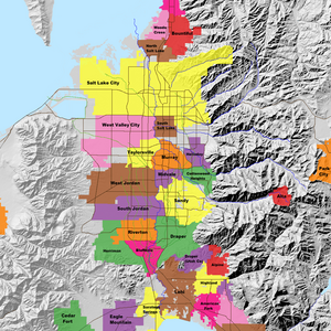
The Salt Lake Valley is fed by seven streams from the surrounding mountains. All the runoff water eventually ends in the Great Salt Lake, which has no outlet. The mountains rise precipitously from the relatively flat valley surfaces, indicating their comparatively youthful formation. The county has a total area of 807 square miles (2,090km2), of which 742 square miles (1,920km2) is land and 65 square miles (170km2) (8.1%) is water.[13] It is the fifth-smallest county in Utah by area. The county borders on the Great Salt Lake and is traversed by the northward flowing Jordan River.[14]
The western portion of the county descends toward the valley of the lake,[14] but perhaps the most dominating physical feature in Salt Lake County is the Wasatch Mountains in the eastern portion of the county, famous for both summer and winter activities. The mountains are administered as part of the Wasatch-Cache National Forest. The mountains' snow is touted in state-sponsored publicity as 'Greatest Snow on Earth' for its soft, powdery texture, and led to Salt Lake City's winning the bid for the 2002 Winter Olympics. Salt Lake County has four ski resorts: Snowbird and Alta in Little Cottonwood Canyon and Solitude and Brighton in Big Cottonwood Canyon. Hiking and camping are popular summer activities. The Oquirrh Mountains border the western part of the county. These two mountain ranges, together with the much smaller Traverse Mountains at the south of the valley, delimit Salt Lake Valley, which is also flanked on the northwest by the Great Salt Lake, and on the north by the Salt Lake Anticline (including Ensign Peak).
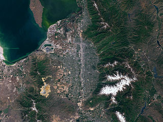
Salt Lake County and surrounding area as seen from above
On the north and east benches, houses have been built halfway up the mountain to the boundary of the national forest, assuming greater risk from wildfires. New communities are also being constructed on the southern and western slopes. Rapid residential construction continues in the west-central, southwest, and southern portions of the valley. In the far west, southwest, and northwest, rural areas still exist, but rapid growth threatens what remains of the natural environment in the valley. The County government operates several large parks in the valley (including some with incorporated cities), including Big Cottonwood Park, Crestwood Park, and an Equestrian Center.
Access
Traffic into the Salt Lake Valley passes through four narrow geographic features: Parley's Canyon to the east; the space between the Salt Lake Anticline and the Great Salt Lake leading into Davis County to the north; the Point of the Mountain and adjacent Jordan Narrows leading to Utah County to the south; and a space (known as Garfield) between the Oquirrh Mountains and the Great Salt Lake leading to Tooele County to the west. Of these, only the connection to Davis County to the north is wide enough and flat enough to accommodate transportation routes without reliance on earthworks.
Annual precipitation for the Salt Lake Valley is around 15 inches (380mm), usually with more on the east side and less on the west side, as most storms come from the Pacific Ocean and the west side is in the rain shadow of the Oquirrh Mountains. Up to 19 inches (480mm) is received on the east benches. Most of this precipitation is received in spring. The summer is dry, with the majority of precipitation arriving from the monsoon that rises from the south. Short, localized, and often dry thunderstorms are usually associated with the monsoon. However, some can be very intense. These storms can cause contrasting emergencies of flash floods and wildfires (due to dry lightning and powerful winds). Precipitation is heaviest in late fall/early winter and in spring, while early summer is the driest season.
Annual snowfall in the valley is 55 inches (140cm), with up to 100 inches (250cm) on the benches. The most snow falls between mid-November and late March. The mountains receive up to 500 inches (1,300cm) of light, dry snow and up to 55 inches (140cm) of precipitation annually. The dry snow is often considered good for skiing, contributing to the four ski resorts in the county. Snow usually falls from October through May. The heavy snow totals across the county can be attributed to the lake-effect, where precipitation is intensified by the warm waters of the Great Salt Lake, which never entirely freezes due to the lake's high salinity. The lake effect can affect any area of the county, depending on wind conditions. The dry snow is attributed to the low humidity of the region.
During winter, temperature inversions are common, causing air pollution in the valley. They trap pollutants, moisture, and cold temperatures in the valley while the surrounding mountains enjoy warm temperatures and clear skies. This can cause some melting snow in the mountains and unhealthy air quality, and low visibility in the valley. This weather event lasts from a few days to a month in extreme cases and is caused when an area of high pressure forms over the Great Basin.
1The 2000 census was the first to allow residents to select multiple race categories. Prior to 2000, the census used the category 'Other Race' as a catch-all identifier. For county-level census data in 1950 and 1900, Utah counted all non-White and non-Black residents using this category. Asian and Hispanic Americans were counted by national origin (i.e. Mexican).
As of the 2020 United States census, there were 1,185,238 people in the county, of whom 874,895 (73.8%) were aged 18 years or older. The population density was 1,597.2 per sq. mi. of land area (616.7/km2). There were 428,279 housing units, for a density of 571.1 per sq. mi. of land area (222.8/km2). Of these, 405,229 (94.6%) were occupied.[25]
The 2020 census racial makeup of the county was 71.5% White alone (80.9% alone or in combination), 70.3% non-Hispanic white, 2.0% Black or African American alone (2.9% alone or in combination), 1.1% Native American or Alaska Native alone (2.5% alone or in combination), 4.3% Asian alone (5.8% alone or in combination), 1.8% Pacific Islander alone (2.5% alone or in combination), 9.4% from some other race alone (15.8% alone or in combination), and 9.9% from two or more races. 19.6% of the population were Hispanic or Latino of any race.[25]
The US Census Bureau estimate for 2019[26] lists 1,160,437 people in Salt Lake County. The racial makeup of the county was 70.3% non-Hispanic White, 2.2% Black, 1.4% Native American, 4.6% Asian, 1.8% Pacific Islander, and 2.9% from two or more races. 18.8% of the population were Hispanic or Latino of any race.
As of the 2010 United States census, there were 1,029,655 people, 343,218 households, and 291,686 families in the county. The population density was 1,388 per square mile (536/km2). There were 364,031 housing units at an average density of 491 per square mile (190/km2). The racial makeup of the county was 81.2% White, 1.59% Black or African American, 0.89% Native American, 3.3% Asian, 1.53% Pacific Islander, 8.35% from other races, and 3.14% from two or more races. 17.09% of the population were Hispanic or Latino of any race.
In 2010 there were 343,218 households, out of which 40.10% had children under the age of 18 living with them, 57.80% were married couples living together, 10.40% had a female householder with no husband present, and 27.50% were non-families. 20.80% of all households were made up of individuals, and 6.20% had someone living alone who was 65 years of age or older. The average household size was 3.00 and the average family size was 3.53.
In terms of age, 30.5% of the county's population was under the age of 18, 12.90% from 18 to 24, 30.60% from 25 to 44, 18.00% from 45 to 64, and 8.10% was 65 years of age or older. The median age was 29 years. For every 100 females, there were 101.70 males. For every 100 females age 18 and over, there were 99.70 males.
The median income for a household in the county was $48,373, and the median income for a family was $54,470. Males had a median income of $36,953 versus $26,105 for females. The per capita income for the county was $20,190. About 5.70% of families and 8.00% of the population were below the poverty threshold, including 9.00% of those under age 18 and 5.50% of those age 65 or over.
The 2005 American Community Survey indicated that 11.4% of Salt Lake County's population living in households (as opposed to group arrangements such as college dormitories) spoke Spanish at home.
Religion
According to data from the LDS Church and the State of Utah, Salt Lake County was 50.6% LDS (Mormon) in 2008, as reported in the Deseret News.[27] By 2013, this had increased to 51.41%.[28] However, by 2020, this had decreased to 46.89%.[29]
Salt Lake County Court Minutes, Book A, Page 1, March 15, 1852
The first governing administrative body of the county was made up of the probate court and judge, Elias Smith, and three selectmen: Samuel Moore, Reuben Miller, and J.C. Wright. The first order of business on March 15 was to appoint a county Assessor/Collector, S. Eldridge. Second order was the appointment of a county Treasurer, Thomas Rhodes, and the third and fourth orders of business for the day was setting the rate of taxation on taxable property, at .5% of $0.01, and .25% of $0.01, as a road tax.[30] The Court (probate section) adjudicated in civil and criminal cases in the county.
Commission, June 8, 1896 – January 1, 2001
Salt Lake County, Board of County Commissioners Meeting Minutes, First Meeting, Book H, page 2697, June 8, 1896
The Board of County Commissioners began its duties on June 8, 1896,[31] with Utah's statehood. Though the judge was removed when the court was abolished upon statehood, the Selectmen stayed on in their offices until elections to fill the new commission seats were held. The first commissioners elected were: A.S. Geddes, M. Christopherson, and C.H. Roberts. The Commission took over all duties the Court and Selectmen performed. The County Court house was demolished[32] after the completion of the Salt Lake City and County Building in Downtown Salt Lake City in the mid-1890s. The new County Commission governed at the City and County Building until 1986 when the county government moved its offices to the newly built the Salt Lake County Government Center at State Street and 2100 South, formerly the location of the County Hospital, which was demolished in early the 1980s to build the County Government Center.[33]
Council and mayor, January 1, 2001
The county currently has a mayor–council form of government. The position of mayor is decided in partisan elections; the current mayor (as of January 2019) is Jenny Wilson, a Democrat.[34] Former county mayors include Peter Corroon, Nancy Workman and Alan Dayton (Workman's deputy mayor; sworn in as acting mayor in September 2004 when Nancy Workman was placed on paid administrative leave). The County Council is composed of three seats elected at-large and six elected by district. District-elected councilors are elected to staggered four-year terms; the at-large councilors are elected to six-year terms. See district maps
6th District — Dea Theodore (R) (Vice Chair) — Bio
Politics and government
Like most of Utah, Salt Lake County usually favors candidates from the Republican Party. While it is somewhat conservative for an urban county, it has been somewhat friendlier to Democrats than the rest of the state, and has traditionally been more competitive in state and local elections than Utah as a whole. As evidence of this, all but one Democrat in the state House of Representatives and all six Democrats in the state Senate represent districts based in the county.
In 2004, Republican President George W. Bush won the county over DemocratJohn Kerry 59% to 37%. In 2008, however, Democrat Barack Obama won Salt Lake County by an extremely narrow margin, 48.17% to 48.09%, over Republican John McCain—a difference of 296 votes.[35] It was the first time since 1964, when Lyndon B. Johnson was the Democratic candidate, that Salt Lake County had voted for a Democrat in a presidential race. In 2012, the Republicans recaptured the county, as Mitt Romney received 58% of the vote to Obama's 38%.[36] In 2016, Democrat Hillary Clinton won the county with 41.5% of the vote, to Republican Donald Trump's 32.6% and Independent and Utah-native Evan McMullin's 25.9%—a much wider margin of over 35,000 votes. In 2020, Salt Lake County saw a strong Democratic trend when Joe Biden carried it with 53% of the vote. He was the first Democratic presidential candidate to win a majority of the county's vote since Johnson.
Democratic strength in the county is mainly concentrated in Salt Lake City and closer inner ring suburbs like South Salt Lake and Millcreek. Other inner ring suburbs in the I-215 corridor such as West Valley City tend to be swing towns. Sandy and West Jordan tend to lean more Republican, and the other outer-ring suburbs in the southern part of the county like South Jordan are strongly Republican.
The bulk of the county was for a long time located in the 2nd congressional district. However, after Utah gained a seat following the 2010 census redistricting, the Republican-controlled state legislature split the county into three districts – 2nd, 3rd and 4th. Despite that, since 2000 Republicans have only controlled most of the county in the Congress only for four years – from 2015 to 2019, after Jim Matheson, who survived two redistrictings following 2000 and 2010 censuses, retired and was replaced by Mia Love, who in turn, was defeated by former county mayor Ben McAdams in 2018 election.
Only one Republican (Workman) has ever been elected county mayor. Since its inception, the county council has mostly been Republican-controlled, save for two years in 2009–2011, when Democrats had a narrow 5-4 majority following the 2008 election.
The county last voted for the Democratic candidate for governor in 2004, and for a Democratic Senate candidate in 1974,[37] although, it voted for independent candidate Evan McMullin in 2022.
The region's economy used to revolve around LDS services and mining. While both are still important to the economy, each has greatly declined in significance since the 19th century. Since World War II, defense industries in the region have also played a very important role in the economy due to its strategic central location in the Western United States, as well as the largely uninhabited and desolate Great Salt Lake Desert to the west (used for training, weapons testing, and storage of hazardous materials).
Beginning in 1939, with the opening of Alta Ski Area, skiing and other winter sports (as well as summer sports), have become a major force in the economy. In 1995, Salt Lake City won the bid to host the 2002 Winter Olympics. The 2002 Olympics boosted tourism and the economy, and helped to dramatically improve transportation throughout the county. Transportation has been a major focus, as the county continues to rapidly grow in population. It was drastically improved beginning in the late 80s and through the 90s, and continues to this day. Beginning in the 1960s, a more service-oriented economy began to develop, and information technologies began to arrive in the 80s and 90s. Although this business has waned in recent years, information and computer companies, such as iBAHN, InContact, Mstar, Opengear, and Overstock.com are still thriving businesses here.
Salt Lake City and Murray operate their own school districts (although a recent[when?] annexation by Murray leaves a part of the city within the Granite School District). The Granite School District, the third largest in the state, is a broad district that covers a swath from Magna, Kearns, and Taylorsville through West Valley City and eastward to South Salt Lake and Millcreek. The Jordan School District, with approximately 48,000 students, covers the southwest part of the county, including most of West Jordan, South Jordan, Riverton, Herriman, Bluffdale, and Copperton.[citation needed]
On November 6, 2007, the east side residents of the Jordan School District in Sandy, Draper, Midvale, Cottonwood Heights, Alta, and nearby unincorporated areas voted to split from the Jordan District, creating the Canyons School District. A similar vote to make West Jordan its own district, however, failed.[96]
South High School in Salt Lake City closed in 1988; it is now occupied by the City Campus of the Salt Lake Community College (SLCC).
Granite High School in South Salt Lake was reformed into an alternative school in 2006, although it remained a public school. However, this venture was not a financial success and the school closed in 2009. The school building was demolished in 2018 in preparation for the site to be redeveloped. The site is now the location of Salt Lake County Library's Granite branch.[97]
Salt Lake County is home to the Bastian Agricultural and Equestrian Center, which also serves as an extension and distance education location for Utah State University.
Infrastructure
Transportation
Because the restricted geography permits only four major entrances to the Salt Lake Valley, routes for long-distance travel through the valley are mainly confined to an east–west strip through Salt Lake City and South Salt Lake and a north–south strip near the Jordan River. These corridors cross in the area between South Salt Lake and Downtown Salt Lake City and together form a latin cross of transportation infrastructure that is almost perfectly oriented north-to-south.
A light rail system, known as TRAX, is operated by the Utah Transit Authority (UTA) and currently has three lines. The Blue Line runs from Downtown Salt Lake City to Draper), the Red Line from South Jordan to the University of Utah, and the Green Line from West Valley City to the Salt Lake City International Airport (via Downtown Salt Lake City). There are currently 50 stops in the system. The original line opened in 1999 from downtown to Sandy, with the line to the University of Utah completed in 2001, and to West Valley City and South Jordan in 2011. In April 2013 the extension to the airport (Airport Station) on the Green Line opened and the extension to Draper (Draper Town Center Station) on the Blue Line opened in August 2013.
An historic streetcar was proposed along 2100 South from the TRAX station to the historic business district in the Sugar House neighborhood.[99] The proposal was refined and in December 2013, a modern (S Line) light rail track was completed and is operated by UTA. A future extension is planned to run north along Highland Drive and 1100 East to 1700 South.
Roads
The county is traversed by three Interstate Highways and one U.S. Highway, as well as an additional freeway and one major expressway. US-89 enters from Davis County to the north and traverses the county arrow-straight until merging with I-15 in north Draper. It is known as State Street along most of the route and is the primary surface road in the valley. I-15 and I-80 intersect just west of Downtown Salt Lake City, merging for approximately 3 miles (4.8km) north-to-south. I-80 continues west past the Salt Lake City International Airport and east through Parley's Canyon and into the Wasatch Range. I-15 traverses the valley north-to-south, providing access to the entire urban corridor. The freeway is 10–12 lanes wide after a major expansion project from 1998 to 2001 undertaken in preparation for the 2002 Winter Olympics. I-215 directly serves many of the suburbs of Salt Lake City in the western, central, and eastern portions of the valley in a 270° loop. SR-201, alternatively known as the "21st South Freeway", provides access to West Valley City and the west side of the valley. Bangerter Highway (SR-154) is an expressway that traverses the entire western end of the valley from the airport, ending at I-15 in southern Draper. SR-68, or Redwood Road, is the only surface street that traverses the entire valley from north-to-south. The Legacy Parkway opened in 2008 to connect with I-215 at the north end of the valley, providing an alternative route into Davis County to alleviate congestion. The Mountain View Corridor is a limited-access highway across the southwestern part of the county; construction began in 2010 and it was put into operation in stages.
The Utah Transit Authority operates bus routes throughout the valley and along the Wasatch Front, to Park City and Tooele, and to the ski resorts in winter.
Pedestrian and bicycle trails
The Jordan River Parkway trail (and its northern extension, the Legacy Parkway trail) runs north–south in the center of the valley from Utah County to Davis County (though it has a few gaps), and the planned Crosstown and Parley's trails will together form the primary east–west route from Parley's Canyon to Garfield. The Bonneville Shoreline Trail runs along the face of the Wasatch mountains, skirting the edge of the built up areas of the east bench, though there are large gaps in the central part of the county. A large number of more remote trails provide access throughout the Wasatch-Cache National Forest.
Bingham Canyon, incorporated 1904, disincorporated 1971. The last buildings were razed in 1972 as the Bingham Canyon Mine absorbed the town. At its peak the population was around 15,000.
Lark was a small town on the southwest side of the valley that was dismantled in 1978 to make way for overburden from the Bingham Canyon Mine. At its peak the population was around 800.
Riter started out as a station on the San Pedro, Los Angeles, and Salt Lake Railroad in 1905 and a town formed in its vicinity. In 1918, the town and station were buried by an expansion of one of Kennecott's tailings ponds west of Magna. The station was moved north but in 1996 the location was again buried by another expansion of the tailings pond although by that time Riter was only a siding and there were no buildings there.
Utah is a landlocked state in the Mountain West subregion of the Western United States. It borders Colorado to its east, Wyoming to its northeast, Idaho to its north, Arizona to its south, and Nevada to its west. Utah also touches a corner of New Mexico in the southeast. Of the fifty U.S. states, Utah is the 13th-largest by area; with a population over three million, it is the 30th-most-populous and 11th-least-densely populated. Urban development is mostly concentrated in two areas: the Wasatch Front in the north-central part of the state, which is home to roughly two-thirds of the population and includes the capital city, Salt Lake City; and Washington County in the southwest, with more than 180,000 residents. Most of the western half of Utah lies in the Great Basin.
Davis County is a county in northern Utah, United States. As of the 2020 United States Census, the population was 362,679, making it Utah's third-most populous county. Its county seat is Farmington, and its largest city by both population and area is Layton.
Cache County is a county located in the Wasatch Front region of Utah. As of the 2020 United States Census, the population was 133,154, with an estimated 140,173 in 2022. Its county seat and largest city is Logan. Cache County is one of two counties included in the Logan metropolitan area, alongside Franklin County, Idaho.
Box Elder County is a county at the northwestern corner of Utah, United States. At the 2020 census, the population was 57,666, up from the 2010 figure of 49,975. Its county seat and largest city is Brigham City. The county was named for the box elder trees that abound in the county.
Duchesne County is a county in the northeast part of the U.S. state of Utah. As of the 2020 United States Census, the population was 19,596. Its county seat is Duchesne, and the largest city is Roosevelt.
Juab County is a county in western Utah, United States. As of the 2020 United States Census, the population was 11,786. Its county seat and largest city is Nephi.
Morgan County is a county in northern Utah, United States. As of the 2020 census, the population was 12,295. Its county seat and largest city is Morgan. Morgan County is part of the Ogden-Clearfield, UT Metropolitan Statistical Area as well as the Salt Lake City-Provo-Orem, UT Combined Statistical Area.
Summit County is a county in the U.S. state of Utah, occupying a rugged and mountainous area. As of the 2020 United States Census, the population was 42,357. Its county seat is Coalville, and the largest city is Park City.
Sanpete County is a county in the U.S. state of Utah. As of the 2020 United States Census, the population was 28,437. Its county seat is Manti, and its largest city is Ephraim. The county was created in 1850.
Tooele County is a county in the U.S. state of Utah. As of the 2020 United States Census, the population was 72,698. Its county seat and largest city is Tooele. The county was created in 1850 and organized the following year.
Wasatch County is a county in the U.S. state of Utah. As of the 2020 United States Census, the population was 34,788. Its county seat and largest city is Heber City. The county was named for a Ute word meaning "mountain pass" or "low place in the high mountains".
Utah County is the second-most populous county in the U.S. state of Utah. The county seat and largest city is Provo, which is the state's fourth-largest city, and the largest outside of Salt Lake County. As of the 2020 United States Census, the population was 665,665.
Washington County is a county in the southwestern corner of Utah, United States. As of the 2020 United States Census, the population was 180,279, making it the fifth-most populous county in Utah. Its county seat and largest city is St. George. The county was created in 1852 and organized in 1856. It was named after the first President of the United States, George Washington. A portion of the Paiute Indian Reservation is in western Washington County. Washington County comprises the St. George, UT Metropolitan Statistical Area.
Weber County is a county in the U.S. state of Utah. As of the 2020 census, the population was 262,223, making it Utah's fourth-most populous county. Its county seat and largest city is Ogden, the home of Weber State University. The county was named after a fur trapper John Weber.
Sandy is a city in the Salt Lake City metropolitan area, located in Salt Lake County, Utah, United States. The population was 96,904 according to the 2020 United States Census.
Heber City is a city and county seat of Wasatch County, Utah. The population was 16,856 as of the 2020 United States census. The city is located 43 miles southeast of Salt Lake City.
Draper is a city in Salt Lake and Utah counties in the U.S. state of Utah, about 20 miles (32 km) south of Salt Lake City along the Wasatch Front. As of the 2020 census, the population is 51,017, up from 7,143 in 1990.
The Wasatch Front is a metropolitan region in the north-central part of the U.S. state of Utah. It consists of a chain of mostly contiguous cities and towns stretched along the Wasatch Range from approximately Santaquin in the south to Logan in the north, and containing the cities of Salt Lake City, Bountiful, Layton, and Ogden.
Salt Lake Valley is a 500-square-mile (1,300 km2) valley in Salt Lake County in the north-central portion of the U.S. state of Utah. It contains Salt Lake City and many of its suburbs, notably Murray, Sandy, South Jordan, West Jordan, and West Valley City; its total population is 1,029,655 as of 2010. Brigham Young said, "this is the right place," when he and his fellow Mormon settlers moved into Utah after being driven out of several states.
This page is based on this Wikipedia article Text is available under the CC BY-SA 4.0 license; additional terms may apply. Images, videos and audio are available under their respective licenses.