
Green is a city in southeastern Summit County, Ohio, United States. The population was 27,475 at the 2020 census. It is a suburban community between Akron and Canton and is part of the Akron metropolitan area.

Dover Township is one of the fourteen townships of Athens County, Ohio, United States. The 2020 census found 3,387 people in the township.
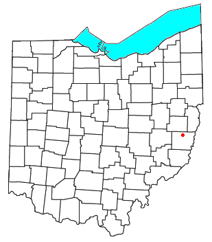
Jacksontown is a census-designated place (CDP) in central Licking Township, Licking County, Ohio, United States. It has a post office with the ZIP code 43030. It lies at the intersection of U.S. Route 40 with State Route 13.

Buford is an unincorporated community and census-designated place in central Clay Township, Highland County, Ohio, United States. The population was 306 at the 2020 census. It once had a post office, with the ZIP code 45110. The current ZIP code 45171 is for nearby Sardinia.

Tippecanoe is an unincorporated community and census-designated place (CDP) in central Washington Township, Harrison County, Ohio, United States. It is located along State Route 800 in the valley of Stillwater Creek, a north-flowing tributary of the Tuscarawas River. It had a post office until 2011 with the ZIP code 44699. The population was 83 at the 2020 census.
Buffalo is an unincorporated community and census-designated place in eastern Valley Township, Guernsey County, Ohio, United States. As of the 2020 census it had a population of 373. It has a post office with the ZIP code 43722. It lies along State Route 313.

Parkman is a census-designated place in southern Parkman Township, Geauga County, Ohio, United States. It has a post office with the ZIP code 44080. It lies along U.S. Route 422 at its intersection with State Routes 88, 168, and 528.

Radnor is an unincorporated community and census-designated place (CDP) in central Radnor Township, Delaware County, Ohio, United States. As of the 2020 census it had a population of 180. Radnor has a post office with the ZIP code of 43066. It lies along State Route 203 at its intersection with Radnor Road.

Kilbourne is a census-designated place in eastern Brown Township, Delaware County, Ohio, United States. As of the 2020 census it had a population of 127. The community has a post office with the ZIP code of 43032. It lies along State Route 521.
Bannock is a census-designated place in northwestern Richland Township, Belmont County, Ohio, United States, along Wheeling Creek. As of the 2020 census it had a population of 159. It has a post office with the ZIP code 43972. It lies along State Route 331.

Damascus is an unincorporated community and census-designated place in southern Mahoning and northern Columbiana counties in the U.S. state of Ohio. As of the 2020 census, it had a population of 418. The community lies at the intersection of U.S. Route 62 and State Routes 173 and 534.

Haydenville is an unincorporated community and census-designated place (CDP) in southern Green Township, Hocking County, Ohio, United States. As of the 2020 census the population of the CDP was 337.

Carbon Hill is an unincorporated community and census-designated place (CDP) in central Ward Township, Hocking County, Ohio, United States. It has a post office with the ZIP code 43111. As of the 2020 census the population of the CDP was 178.

Stewart is an unincorporated community and census-designated place in central Rome Township, Athens County, Ohio, United States. The population was 221 at the 2020 census. It has a post office with the ZIP code 45778.

New Marshfield is a census-designated place in central Waterloo Township, Athens County, Ohio, United States. The population was 316 at the 2020 census. It has a post office with the ZIP code 45766. It is located along State Route 56 west of the county seat of Athens.

Hockingport is a census-designated place in southeastern Troy Township, Athens County, Ohio, United States. As of the 2020 census it had a population of 205. It has a post office with the ZIP code 45739. It is located at the intersection of State Routes 124 and 144.

Dundee is a census-designated place in central Wayne Township, Tuscarawas County, Ohio, United States. It has a post office with the ZIP code 44624. It lies at the intersection of State Routes 93 and 516. The population was 269 at the 2020 census.

Sandyville is an unincorporated community and census-designated place in northern Sandy Township, Tuscarawas County, Ohio, United States. It has a post office with the ZIP code 44671. It lies along State Route 800 between Canton and New Philadelphia. The population was 350 at the 2020 census.

Reno is a census-designated place in southern Marietta Township, Washington County, Ohio, United States. It has a post office with the ZIP code 45773. It is located on the Ohio River a short distance south of the county seat of Marietta. State Route 7 forms its main street. The population was 1,129 at the 2020 census.

Newport is a census-designated place in eastern Newport Township, Washington County, Ohio, United States. It has a post office with the ZIP code 45768. Newport lies along the Ohio River several miles above the county seat of Marietta. Today its main street is designated as State Route 7. The population of the CPD was 895 at the 2020 census.


