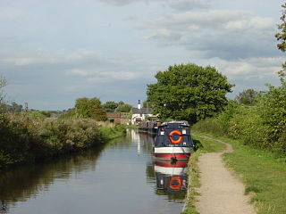
The Trent and Mersey Canal is a 93+1⁄2-mile (150 km) canal in Derbyshire, Staffordshire and Cheshire in north-central England. It is a "narrow canal" for the vast majority of its length, but at the extremities to the east of Burton upon Trent and north of Middlewich, it is a wide canal.

Endon is a village within the Staffordshire Moorlands district of Staffordshire, England. It is 4 miles (6.4 km) southwest of Leek and 6 miles (9.7 km) north-northeast of Stoke-on-Trent. Endon was formerly a township in civil parish of Leek.
Stoke-on-Trent is a city and unitary authority area in Staffordshire, England, with an area of 36 square miles (93 km2). In 2021, the city had an estimated population of 258,400. It is the largest settlement in Staffordshire and is surrounded by the towns of Newcastle-under-Lyme, Alsager, Kidsgrove and Biddulph, which form a conurbation around the city.

Caldon Canal is a branch of the Trent and Mersey Canal which opened in 1779. It runs 18 miles (29 km) from Etruria, Stoke-on-Trent, to Froghall, Staffordshire. The canal has 17 locks and the 76-yard (69 m) Froghall Tunnel.

Stoke-on-Trent North is a constituency represented in the House of Commons of the UK Parliament since 2019 by Jonathan Gullis, a member of the Conservative Party.

Barlaston is a village and civil parish in the borough of Stafford in the county of Staffordshire, England. It is roughly halfway between the city of Stoke-on-Trent and the small town of Stone. According to the 2001 census the population of the parish was 2,659, rising at the 2011 Census to 2,858.

Smallthorne is an area in the city of Stoke-on-Trent in Staffordshire, England. It is in the north-east of the city, near Burslem. Smallthorne borders Bradeley and Chell in the north, Norton-in-the-Moors in the east, Sneyd Green in the south, and Burslem in the west.
Fradley is a village and civil parish, in the Lichfield district, in the county of Staffordshire, England. In 1881 the parish had a population of 380.

Marchington Woodlands is a village and former civil parish, now in the parish of Marchington, in the East Staffordshire district, in the county of Staffordshire, England. It has a church and a village hall. The local first school was closed in 1981 and the building was converted into a private home. Marchington Woodlands consists mostly of farms and cottages. it is often Referred to by locals as The Woodlands. It is located near Uttoxeter. In 1931 the parish had a population of 273.
Sneyd Green is an area in the city of Stoke-on-Trent, Staffordshire, England, in the north-east of the city, 1.5 miles (2.4 km) from Hanley. Sneyd Green borders Smallthorne in the north, Milton in the east, Birches Head in the south, and Cobridge in the west.
Smallthorne Urban District was an urban district in Staffordshire, England. It was initially formed of the Smallthorne civil parish. In 1904 the Chell and Milton civil parishes were added. It was abolished in 1922 with the bulk of it becoming part of the county borough of Stoke-on-Trent.
Norton le Moors is in the north-east of the city of Stoke-On-Trent, Staffordshire, England, mostly within the city boundary, with the rest in the Staffordshire Moorlands district.

Goldenhill is an area on the northern edge of Stoke-on-Trent, in the Stoke-on-Trent district, in the ceremonial county of Staffordshire, England. It is centred along the High Street, part of the A50 road that runs from south-east to north-west. It is about 1 mile (1.6 km) north of Tunstall and 1.5 miles (2.4 km) south-east of Kidsgrove.
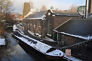
The Etruria Industrial Museum is located in Etruria, Staffordshire, in England. The museum is a typical and well-preserved example of a nineteenth century British steam-powered potter's mill. It is situated between the Trent and Mersey Canal and the Etruria staircase locks of the Caldon Canal. The museum has a modern entrance building, leading into a Grade II* listed building which was formerly the Etruscan bone and flint mill. The mill is also a scheduled monument.

Ford Green Brook flows through Staffordshire and the outlying areas of Stoke-on-Trent, England. It is the first named tributary stream of the River Trent, and is 6.2 miles (10 km) long.

Chell is a suburb of the city of Stoke-on-Trent in the ceremonial county of Staffordshire, England, that can be subdivided into Little Chell, Great Chell and Chell Heath. It lies on the northern edge of the city, approximately 1-mile (1.6 km) from Tunstall, 2 miles (3.2 km) from Burslem and 3 miles (4.8 km) from the county border with Cheshire. Chell borders Pitts Hill to the west, Tunstall to the south west, Stanfield and Bradeley to the south, with the outlying villages of Packmoor and Brindley Ford to the north and Ball Green to the east. Since 2011 the area has been divided into the electoral wards of Bradeley & Chell Heath, Great Chell & Packmoor and Little Chell & Stanfield.
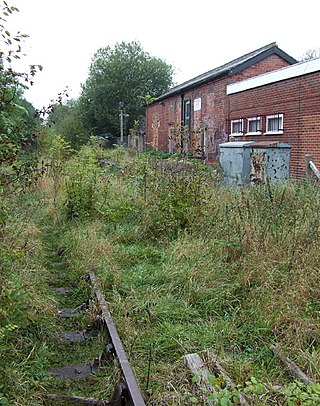
Endon railway station is a disused railway station in Staffordshire.
Baddeley Edge is a hamlet in the north of the city of Stoke-on-Trent, in the north of the county of Staffordshire.

The Stoke-on-Trent Green Belt is a green belt environmental and planning policy that regulates the rural space throughout mainly the West Midlands region of England. It is contained within the counties of Cheshire and Staffordshire. Essentially, the function of the designated area is to prevent surrounding towns and villages within the Stoke-on-Trent conurbation from further convergence. It is managed by local planning authorities on guidance from central government.
The Biddulph Valley line was a double tracked line that ran from Stoke-on-Trent to Brunswick Wharf in Congleton. The line was named after the town of the same name as it ran via the Staffordshire Moorlands and covered areas of East Staffordshire and Cheshire.

