Mississippi River System

Last updated
Mississippi River System
Mississippi watershed map 1.jpg
Mississippi River course, watershed, and major tributaries
Mississippiriver-new-01.png
Details of the Mississippi River tributaries
Location
Country United States and Canada
Physical characteristics
Mouth  
  location
Gulf of Mexico
  coordinates
29°09′04″N89°15′12″W / 29.15111°N 89.25333°W / 29.15111; -89.25333
  elevation
0 ft (0 m)
Basin size1,151,000 km2 (444,000 sq mi)
Discharge 
  locationmouth; max and min at Baton Rouge, LA [1]
  average593,000 cu ft/s (16,800 m3/s) [1]
  minimum159,000 cu ft/s (4,500 m3/s)
  maximum3,065,000 cu ft/s (86,800 m3/s)
Discharge 
  location St. Louis [2]
  average168,000 cu ft/s (4,800 m3/s) [2]

The Mississippi River System, also referred to as the Western Rivers, is a mostly riverine network of the United States which includes the Mississippi River and connecting waterways. The Mississippi River is the largest drainage basin in the United States. [3] In the United States, the Mississippi drains about 59% of the country's rivers. [4]

Contents

From the perspective of natural geography and hydrology, the system consists of the Mississippi River itself and its numerous natural tributaries and distributaries. The major tributaries are the Illinois, Missouri, Ohio and Red rivers. Given their flow volumes, major Ohio River tributaries like the Allegheny, Tennessee, and Wabash rivers are considered important tributaries to the Mississippi system. [5] Before the Mississippi River reaches the Gulf of Mexico, it runs into its distributary, the Atchafalaya River. [3]

From the perspective of modern commercial navigation, the system includes the above as well as navigable inland waterways which are connected by artificial means. Important connecting waterways include the Illinois Waterway, the Tennessee-Tombigbee Waterway, and the Gulf Intracoastal Waterway. is maintained by the U.S. Army Corps of Engineers with a project depth of between 9–12 ft (2.7–3.7 m) to accommodate barge transportation, primarily of bulk commodities. [6]

The Mississippi River carries 60% of U.S. grain shipments, 22% of oil and gas shipments, and 20% of coal. [7]

Major tributaries

Major Tributaries of the Mississippi River System
RiverLengthSourceMouthStates
1. Upper Mississippi River 1,250 mi (2,010 km) Lake Itasca, Minnesota St. Louis, Missouri Minnesota, Wisconsin, Iowa, Illinois, Missouri
2. Arkansas River 1,469 mi (2,364 km) Leadville, Colorado Franklin Township, Arkansas Colorado, Kansas, Oklahoma, Arkansas
3. Illinois River 273 mi (439 km) Grundy County, Illinois Grafton, Illinois Illinois
4. Missouri River 2,522 mi (4,059 km) Brower's Spring, Montana Spanish Lake, near St. Louis, Missouri Montana, North Dakota, South Dakota, Nebraska, Iowa, Kansas, Missouri
5. Ohio River 981 mi (1,579 km) Allegany Township, Pennsylvania Cairo, Illinois Pennsylvania, Ohio, West Virginia, Kentucky, Indiana, Illinois
6. Red River of the South 1,290 mi (2,080 km) Harmon County, Oklahoma Morgan City, Louisiana Texas, Oklahoma, Arkansas and Louisiana

Upper Mississippi River

Mississippi barge petroleum tanker north of La Crosse. With U.S. 14/61 and the CP Railway running along the rivers edge. Mississippi barge petroleum tanker.jpg
Mississippi barge petroleum tanker north of La Crosse. With U.S. 14/61 and the CP Railway running along the rivers edge.

The Upper Mississippi River spans around 1,250 miles (2,010 km) from Lake Itasca in Minnesota to Cairo, Illinois. [8] Most of the Upper Mississippi goes through the center of the Driftless Area, around 15,000 sq mi (39,000 km2) in Minnesota, Wisconsin, Iowa, and Illinois that has managed to stay free of glacial flows covering the past two million years. [9] The Driftless Area is defined by a multitude of limestone bluffs that have been molded all the way since the last ice age, due to water melting from glaciers. The bottom of the river is composed of a thin layer of clay, silt, loam, and sand, which lay above a stratum of glacial outwash. [9]

The Upper Mississippi River covers approximately half of the Mississippi River's length. About 850 miles (1,370 km) of the river is navigable from Minneapolis-St. Paul (specifically, the Coon Rapids Dam in the City of Coon Rapids, MN) to the Ohio River. The river sustains a large variety of aquatic life, including 127 species of fish and 30 species of freshwater mussels. [10]

Arkansas River

The headwaters of the Arkansas near Leadville, Colorado Arkansas head waters.jpg
The headwaters of the Arkansas near Leadville, Colorado

The Arkansas River is one of the major tributaries in the Mississippi River system. It flows west to east starting in Colorado and dumping into the Mississippi River. Its length of 1,469 miles (2,364 km) allows it to flow through Colorado, Kansas, Oklahoma, and Arkansas. It is the sixth-longest river in the US, the second-longest tributary to the Mississippi River System, and the 45th longest river in the world. [11]

Illinois River

Aerial view of the Illinois River Illinois River aerial.jpg
Aerial view of the Illinois River

The Illinois River is a principal tributary of the Mississippi River. The river runs approximately 273 miles (439 km) long, in the U.S. state of Illinois. [12] This river was important among Native Americans and early French traders as the principal water route connecting the Great Lakes with the Mississippi. The Illinois River meets the Mississippi at Pere Marquette State Park, which is near Grafton.

The Illinois River is relatively shallow, just like the Mississippi. In addition, the Illinois River is a "managed" river, just as the Mississippi River is. In 1848, the Illinois and Michigan Canal opened to connect Lake Michigan with the Mississippi River through the Illinois River to promote commerce.

Missouri River

Boatmen on the Missouri c. 1846 George Caleb Bingham - Boatmen on the Missouri - Google Art Project.jpg
Boatmen on the Missouri c. 1846

The Missouri River is a long stream that originates in southwest Montana and flows southeasterly for 2,522 miles (4,059 km); passing through six states before finally entering the Mississippi River at St. Louis. [13] The Missouri River is the longest river on the North American continent. The Missouri River was one of the main routes for the westward expansion of the United States during the 19th century.

Ohio River

The widest point of the Ohio River near Louisville Ohio River.jpg
The widest point of the Ohio River near Louisville

The Ohio River runs 981 miles (1582 km) long, starting at the meeting of the Allegheny River and the Monongahela River in Pittsburgh, Pennsylvania; ending in Cairo, Illinois, where it then flows into the Mississippi. The Ohio River drains portions of eight states, including, Illinois, Indiana, New York, Ohio, Kentucky, Pennsylvania, Tennessee, and West Virginia.

The river has the capacity to provide enough water for over five million people. It is one mile wide at Smithland dam, the widest point of the river. The depth varies, due to the dams; from its origin point to Cincinnati, it averages approximately 27 feet (8.2 m) before deepening to a maximum 168 feet (51 m) near Louisville, Kentucky.[ citation needed ] These deeper waters allows multiple species of fish to thrive.

The water is also home to 150 species of fish ranging from catfish to certain species of salmon and trout. [14] The depth also allows for commerce throughout the river on barges. On average the Ohio River transports over 230 million tons of cargo. Typically, the cargo being shipped are energy resources such as coal. These resources account for 70% of the cargo. Along with shipping energy resources, the Ohio River also creates energy with dams and other power-generating facilities. There are 20 dams and 49 other power generating facilities along the Ohio River. [15]

Red River of the South

Red River near Bonham, Texas on the Texas-Oklahoma border Redriverbonhamtx.jpg
Red River near Bonham, Texas on the Texas-Oklahoma border

The Red River of the South is the 10th longest river in the United States with a length of 1,290 miles (2,080 km). [11] It originates right outside of the Rocky Mountains and stretches through multiple states with the main portion of it located in Texas. The river also crosses through Oklahoma, Arkansas, and Louisiana where then it links into the Mississippi River. [16] The Red River is mostly surrounded by rural farm land with the only surrounding major cities being Shreveport, Louisiana and Alexandria, Louisiana. The Red River is home to many oil fields with oil and gas production being one of the river's major aspects. The Red River is salty because of ancient seas that covered the area. [17]

Major distributaries

Mississippi River Delta

Mississippi River Delta and Sediment Plume Mississippi River Delta and Sediment Plume.jpg
Mississippi River Delta and Sediment Plume

The Mississippi River Delta was created from thousands of years of sand, clay and organic material being deposited by the Mississippi River into the northern parts of the Gulf of Mexico. The delta is home to massive amounts of wildlife, and attributed to the U.S. success as a superpower because of the economic development the delta has provided for the country.

Over the last three centuries, the delta has continuously collapsed, due to human alterations of the river system. Natural protection of land is exacerbated the more the delta diminishes. The delta is important to the wildlife and people that it supports, along with the US economy. If the land loss continues at the pace it is going, all these benefits can vanish. [18]

Atchafalaya River

Atchafalaya River delta Atchafalaya River delta.jpg
Atchafalaya River delta

The Atchafalaya River is one of the major distributaries in the Mississippi River System. It spans 170 miles (270 km), making it one of the longest distributaries of the Mississippi River. The name of the river translated into English is "long river," which derives from the Native American word. The river is important for commerce because it shortens the distance to the Gulf of Mexico, also saving companies time and money.

The Old River Control Structure diverts a portion of the flow of the Mississippi River into the Atchafalaya River. The diversion is regulated to allow 30% of the combined flow of the Mississippi and Red Rivers to pass down the Atchafalaya River with the remaining flow continuing down the Mississippi River. [19]

Historical use

The river system has always played a pivotal role in the lives of those who inhabit the surrounding area. Several different Native American groups lived in the surrounding area, including the Ojibwa, Ho-Chunk, Meskwaki, and Choctaw Native Americans. The abundance of resources and overall size attracted these individuals to settle near the water. They named the Mississippi River. It was used for assisting with agriculture, gathering fish, and trading with others. [20]

The majority of natives to the river area were hunters and gatherers. The largest users of the rivers were the civilization today referred to as the Mound Builders, which created major farming settlements along the rivers. The silts deposited by the water made the surrounding areas very desirable and an ideal place to farm due to the extremely fertile location. It is unknown as to why earth mounds were constructed, but there is speculation that they possibly were used for religious and ceremonial purposes. [21]

The river system, especially the Mississippi River, was used by Union armies as a means of invading and was host to several large battles during the U.S. Civil War. Mark Twain is regarded as having a large impact on molding U.S. literature into what it is today because of his profound works on adventures and life on the rivers. [20]

Modern use

Tugboat operating on the Mississippi River Mississippi tugboat.jpg
Tugboat operating on the Mississippi River
Barge travelling on the Mississippi River Mississippi River Barge Columbus KY 2023.jpg
Barge travelling on the Mississippi River

Today, the Mississippi River System, along with its connecting tributaries, is primarily used for transporting agricultural and manufactured goods across the span of the country. Among these goods is iron, steel, and mine products. Over 460 million short tons (420 million metric tons) is shipped on the Mississippi each year. The most common form of cargo transportation on the system is by tugboats pushing along large barges. [22]

Commerce

Downbound barge rates
In late 2022 there was low river levels that caused two backups on the Lower Mississippi River that held up over 100 tow boats with 2,000 barge units and caused barge rates to soar Barge rates.webp
Downbound barge rates
In late 2022 there was low river levels that caused two backups on the Lower Mississippi River that held up over 100 tow boats with 2,000 barge units and caused barge rates to soar
Mississippi River levels at Memphis, Tennessee
.mw-parser-output .legend{page-break-inside:avoid;break-inside:avoid-column}.mw-parser-output .legend-color{display:inline-block;min-width:1.25em;height:1.25em;line-height:1.25;margin:1px 0;text-align:center;border:1px solid black;background-color:transparent;color:black}.mw-parser-output .legend-text{}
Major flood stage
Moderate flood stage
Flood stage
Action stage
River levels
Minimum operating limit (-12 feet) Mississippi River Levels at Memphis.webp
Mississippi River levels at Memphis, Tennessee
  Major flood stage
  Moderate flood stage
  Flood stage
  Action stage
  River levels
  Minimum operating limit (-12 feet)

The Mississippi River System is a huge provider for the U.S. economy. It accounts for 92% of the nation's agricultural exports and 78% of the world's feed grains and soybeans. [25] It also houses some of the biggest ports in the U.S. like the Port of South Louisiana and The Port of New Orleans.

These two ports account for over 500 million tons of shipped goods per year which is significantly larger than most ports in the United States. Some common things that are shipped include petroleum, iron, steel, grain, rubber, paper, wood, coffee, coal, chemicals, and edible oils. [26]

Goods Movement

Cargill grain elevator and terminal Cargill grain elevator and terminal.jpg
Cargill grain elevator and terminal

The commodities moved on the Mississippi River in 1999 included the following: [27]

Upbound Commodities
CommodityPercentage
Sand and Gravel47%
Fertilizer24%
Salt9%
Cement10%
Misc.10%
Downbound Commodities
CommodityPercentage
Grain(soy,corn, wheat)87%
Asphalt4%
Potash3%
Misc.6%

Ecology

Natural history

About two billion years ago, environmental tension altered the environment around the Mississippi River System basin, creating the mountain systems in North America. Erosion put further stress on the areas within the rivers, shaping depressions in the ground. Many years after this, the land continued to be molded into the Mississippi River System due to the overflowing of water from nearby oceans, causing constant flooding. Around two million years ago, glaciers up to 1.2 miles (1.9 km) thick continued to disturb the environment. The receding formation of glaciers 15,000 years ago, at the end of the last ice age, left large amounts of water in North America, which created the rivers. [22]

The Mississippi River stemmed from Lake Itasca in northern Minnesota where it was only a tiny outlet stream. It worked its way 2,350 miles (3,780 km) south to the Gulf of Mexico. Today, the Mississippi River is connected to hundreds of tributaries making up the Mississippi River System.

Eagles compete for food at Upper Mississippi River National Wildlife Refuge Food fight (8411457949).jpg
Eagles compete for food at Upper Mississippi River National Wildlife Refuge

Wildlife

The Mississippi River and its floodplain are home to a diverse number of species. There are at least 260 different species of fish throughout the Mississippi. Forty percent of the United States' migratory waterfowl use the Mississippi River corridor during the Spring and Fall migration. Sixty percent of all North American birds (326 species) use the river Basin as their migratory flyway. There are 38 documented species of mussel that can be found from Cairo, IL and upstream to Lake Itasca.

There may be as many as 60 different species of mussel found on the lower part of the Mississippi. More than 50 mammal species have made the Upper Mississippi their home, along with at least 145 species of amphibians and reptiles in the Upper Mississippi environs. [28]

Human impacts

The biggest impact that humans have on the Mississippi River System comes in the form of pollution. Efforts made by the government to regulate and prevent more pollution from entering the waterways have stopped some, but regardless, pollution is still finding its way into the water. Fertilizers and insecticides have been swept away into the water, tampering with the environments ecosystems. [22]

The Mississippi has entered the twenty-first century as a system deeply altered by human actions. Accelerated runoff and accelerated sediment loads, which are associated with running water, have greatly impacted the system due to erosion affecting topsoil in agriculturally heavy areas. [29]

Flooding

Perryville, MO, July 1993 -- An aerial view of floodwaters showing the extent of the damage wreaked by the disaster. FEMA - 13503 - Photograph by Andrea Booher taken on 07-09-1993 in Missouri.jpg
Perryville, MO, July 1993 -- An aerial view of floodwaters showing the extent of the damage wreaked by the disaster.

In 1993, the Mississippi River flood devastated seventeen thousand square miles of land, spanning across nine states. It was the worst flooding epidemic in the history of the United States. It is also referred to as a hundred year flood because the likelihood for it to occur is one in one hundred in any year. Over fifty people died due to the flooding, as well as profound home damage and economic losses totaling $10–12 billion ($20–$25 billion in 2022). Twenty percent of the population that surrounded the flood area have since left due to economic hardship or personal troubles. Today, the Mississippi River System is a deeply orchestrated natural trademark in the United States. [30]

The Army Corps of Engineers currently oversees all the responsibilities of making sure the rivers are best maintained to avoid more flooding. They abide by their goals of to "straighten, channelize, regularize and shackle the Mississippi." In order to subside the potential of more flooding, the Corps created levees, divided by a mile each, to restrict the river and control the flooding. Due to the manner in which the levees were paved, the river is unable to erode the shore. There are several floodways throughout the system to prevent a large amount of water from amassing. Instead, the buildup of water goes through these floodways. While they help prevent flooding, they also inhibit agriculture from prospering in some of the surrounding areas. [4]

See also

Related Research Articles

<span class="mw-page-title-main">Mississippi River</span> Major river in the United States

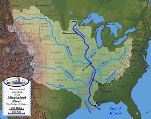
The Mississippi River is the primary river, and second-longest river, of the largest drainage basin in the United States. From its traditional source of Lake Itasca in northern Minnesota, it flows generally south for 2,340 miles (3,766 km) to the Mississippi River Delta in the Gulf of Mexico. With its many tributaries, the Mississippi's watershed drains all or parts of 32 U.S. states and two Canadian provinces between the Rocky and Appalachian mountains. The main stem is entirely within the United States; the total drainage basin is 1,151,000 sq mi (2,980,000 km2), of which only about one percent is in Canada. The Mississippi ranks as the thirteenth-largest river by discharge in the world. The river either borders or passes through the states of Minnesota, Wisconsin, Iowa, Illinois, Missouri, Kentucky, Tennessee, Arkansas, Mississippi, and Louisiana.

<span class="mw-page-title-main">Missouri River</span> Major river in central United States

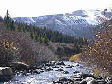
The Missouri River is the longest river in the United States. Rising in the eastern Centennial Mountains of the Bitterroot Range of the Rocky Mountains of southwestern Montana, the Missouri flows east and south for 2,341 miles (3,767 km) before entering the Mississippi River north of St. Louis, Missouri. The river drains semi-arid watershed of more than 500,000 square miles (1,300,000 km2), which includes parts of ten U.S. states and two Canadian provinces. Although a tributary of the Mississippi, the Missouri River is slightly longer and carries a comparable volume of water. When combined with the lower Mississippi River, it forms the world's fourth-longest river system.

<span class="mw-page-title-main">Illinois River</span> Illinois tributary of the Mississippi River in the United States

The Illinois River is a principal tributary of the Mississippi River and is approximately 273 miles (439 km) long. Located in the U.S. state of Illinois, the river has a drainage basin of 28,756.6 square miles (74,479 km2). The Illinois River begins with the confluence of the Des Plaines and Kankakee rivers in the Chicago metropolitan area, and it generally flows to the southwest across Illinois, until it empties into the Mississippi near Grafton, Illinois. Its drainage basin extends into southeastern Wisconsin, northwestern Indiana, and a very small area of southwestern Michigan in addition to central Illinois. Along its shores are several river ports, including Peoria, Illinois. Historic and recreation areas on the river include Starved Rock, and the internationally important wetlands of the Emiquon Complex and Dixon Waterfowl Refuge.

<span class="mw-page-title-main">Distributary</span> Stream branching off from main stream channel

A distributary, or a distributary channel, is a stream that branches off and flows away from a main stream channel, a phenomenon known as river bifurcation. A distributary is effectively the opposite of a tributary, which is a stream that flows towards and into another stream or river. Distributaries are often found where a stream approaches a lake or an ocean; as such, they are a common feature of river deltas. They can also occur inland, on alluvial fans, or where a tributary stream bifurcates as it nears its confluence with a larger stream. In some cases, a minor distributary can divert so much water from the main channel that it can later become the main route.

<span class="mw-page-title-main">Red River of the South</span> Major river in the southern United States

The Red River, or sometimes the Red River of the South to differentiate it from the Red River in the north of the continent, is a major river in the Southern United States. It was named for its reddish water color from passing through red-bed country in its watershed. It is known as the Red River of the South to distinguish it from the Red River of the North, which flows between Minnesota and North Dakota into the Canadian province of Manitoba. Although once a tributary of the Mississippi River, the Red River is now a tributary of the Atchafalaya River, a distributary of the Mississippi that flows separately into the Gulf of Mexico. This confluence is connected to the Mississippi River by the Old River Control Structure.

<span class="mw-page-title-main">Arkansas River</span> Major tributary of the Mississippi River, United States

The Arkansas River is a major tributary of the Mississippi River. It generally flows to the east and southeast as it traverses the U.S. states of Colorado, Kansas, Oklahoma, and Arkansas. The river's source basin lies in Colorado, specifically the Arkansas River Valley. The headwaters derive from the snowpack in the Sawatch and Mosquito mountain ranges. It flows east into Kansas and finally through Oklahoma and Arkansas, where it meets the Mississippi River.

<span class="mw-page-title-main">Wabash River</span> Tributary of the Ohio River in the United States

The Wabash River is a 503-mile-long (810 km) river that drains most of the state of Indiana in the United States. It flows from the headwaters in Ohio, near the Indiana border, then southwest across northern Indiana turning south near the Illinois border, where the southern portion forms the Indiana-Illinois border before flowing into the Ohio River.

<span class="mw-page-title-main">Atchafalaya River</span> Distributary of the Mississippi River in Louisiana, United States

The Atchafalaya River is a 137-mile-long (220 km) distributary of the Mississippi River and Red River in south central Louisiana in the United States. It flows south, just west of the Mississippi River, and is the fifth largest river in North America, by discharge. The name Atchafalaya comes from Choctaw for 'long river', from hachcha, 'river', and falaya, 'long'.

<span class="mw-page-title-main">Kaskaskia River</span> River in the United States

The Kaskaskia River is a tributary of the Mississippi River, approximately 325 miles (523 km) long, in central and southern Illinois in the United States. The second largest river system within Illinois, it drains a rural area of farms, as well as rolling hills along river bottoms of hardwood forests in its lower reaches. The lower reaches of the river have been canalized to allow barge traffic.

<span class="mw-page-title-main">Gulf Coastal Plain</span> Coastal Plain in the Southern United States and Eastern Mexico

The Gulf Coastal Plain extends around the Gulf of Mexico in the Southern United States and eastern Mexico.

<span class="mw-page-title-main">Mississippi River Delta</span> Delta of the Mississippi River

The Mississippi River Delta is the confluence of the Mississippi River with the Gulf of Mexico in Louisiana, southeastern United States. The river delta is a three-million-acre area of land that stretches from Vermilion Bay on the west, to the Chandeleur Islands in the east, on Louisiana's southeastern coast. It is part of the Gulf of Mexico and the Louisiana coastal plain, one of the largest areas of coastal wetlands in the United States. The Mississippi River Delta is the 7th largest river delta on Earth (USGS) and is an important coastal region for the United States, containing more than 2.7 million acres of coastal wetlands and 37% of the estuarine marsh in the conterminous U.S. The coastal area is the nation's largest drainage basin and drains about 41% of the contiguous United States into the Gulf of Mexico at an average rate of 470,000 cubic feet per second.

<span class="mw-page-title-main">Old River Control Structure</span> Floodgate system in Louisiana, USA

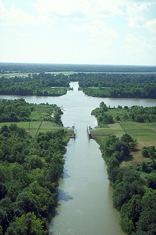
The Old River Control Structure is a floodgate system in a branch of the Mississippi River in central Louisiana. It regulates the flow of water from the Mississippi into the Atchafalaya River, thereby preventing the Mississippi River from changing course. Completed in 1963, the complex was built by the U.S. Army Corps of Engineers in a side channel of the Mississippi known as "Old River", between the Mississippi's current channel and the Atchafalaya Basin, a former channel of the Mississippi.

<span class="mw-page-title-main">Mississippi Valley Division</span> One of the eight permanent divisions of the U.S. Army Corps of Engineers

The United States Army Corps of Engineers Mississippi Valley Division (MVD) is responsible for the Corps water resources programs within 370,000-square-miles of the Mississippi River Valley, as well as the watershed portions of the Red River of the North that are within the United States. It encompasses the entire Mississippi River from Lake Itasca, Minnesota, to the Gulf of Mexico. It excludes the watersheds of the Missouri River and Ohio River, and portions of the Arkansas River and the Red River of the South. The division includes all or parts of 13 states: Arkansas, Illinois, Iowa, Kentucky, Louisiana, Michigan, Minnesota, Mississippi, Missouri, North Dakota, Tennessee, Wisconsin, and South Dakota.

<span class="mw-page-title-main">Inland waterways of the United States</span>

The inland waterways of the United States include more than 25,000 mi (40,000 km) of navigable waters. Much of the commercially important waterways of the United States consist of the Mississippi River System—the Mississippi River and connecting waterways.

<span class="mw-page-title-main">Atchafalaya Basin</span> Largest wetland and swamp in the United States

The Atchafalaya Basin, or Atchafalaya Swamp, is the largest wetland and swamp in the United States. Located in south central Louisiana, it is a combination of wetlands and river delta area where the Atchafalaya River and the Gulf of Mexico converge. The river stretches from near Simmesport in the north through parts of eight parishes to the Morgan City southern area.

<span class="mw-page-title-main">Lower Mississippi River</span> Downstream portion of the Mississippi river

The Lower Mississippi River is the portion of the Mississippi River downstream of Cairo, Illinois. From the confluence of the Ohio River and Upper Mississippi River at Cairo, the Lower flows just under 1000 miles (1600 km) to the Gulf of Mexico. It is the most heavily travelled component of the Mississippi River System.

<span class="mw-page-title-main">River bifurcation</span> The forking of a river into its distributaries

River bifurcation occurs when a river flowing in a single channel separates into two or more separate streams which then continue downstream. Some rivers form complex networks of distributaries, typically in their deltas. If the streams eventually merge again or empty into the same body of water, then the bifurcation forms a river island.

<span class="mw-page-title-main">Wax Lake</span>

Wax Lake was a lake in St. Mary Parish, Louisiana that was converted into an outlet channel, the Wax Lake outlet, to divert water from the Atchafalaya River to the Gulf of Mexico.

<span class="mw-page-title-main">2011 Mississippi River floods</span> Major floods in the United States

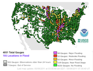
Major floods along the Mississippi River in April and May 2011 were among the largest and most damaging recorded along the U.S. waterway in the past century, comparable in extent to the Great Mississippi Flood of 1927 and Great Flood of 1993. In April 2011, two large storm systems deposited record levels of rainfall on the Mississippi River drainage basin. When that additional water combined with the springtime snowmelt, the river and many of its tributaries began to swell to record levels by the beginning of May. Flooding occurred in Illinois, Missouri, Kentucky, Tennessee, Arkansas, Mississippi, and Louisiana.

<span class="mw-page-title-main">Mississippi flood of 1973</span> Severe weather event in the southern United States

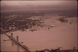
The Mississippi flood of 1973 occurred between March and May 1973 on the lower Mississippi River. The flooding was the third most severe along the U.S.'s Mississippi River during the 20th century.

References

  1. 1 2 Kammerer, J.C. (May 1990). "Largest Rivers in the United States". U.S. Geological Survey. Archived from the original on June 30, 2017. Retrieved February 22, 2011.
  2. 1 2 Median of the 14,610 daily streamflows recorded by the USGS for the period 1967–2006.
  3. 1 2 "The Mississippi/Atchafalaya River Basin (MARB)". www.epa.gov. US Environmental Protection Agency. 24 March 2015. Retrieved 2 November 2016.
  4. 1 2 Watkins, Thayer. "The Missouri-Ohio-Mississippi River System". www.sjsu.edu. San Jose State University. Retrieved 2 November 2016.
  5. "Mississippi River". USGS Biological Resources. Archived from the original on 2005-10-28. Retrieved 2006-03-08.
  6. "The Mississippi River System". US Army Corps of Engineers. Archived from the original on 2006-04-09. Retrieved 2006-03-08.
  7. Alan Greenblatt (2013-01-10). "Mississippi Blues: When The River Doesn't Run". NPR. Retrieved 2015-11-26.
  8. "The Herbert Hoover Presidential Library Association, West Branch, Iowa". Wayback Machine. Hoover Presidential Library Association. 4 January 2006. Archived from the original on 4 January 2006. Retrieved 16 November 2016.{{cite web}}: CS1 maint: bot: original URL status unknown (link)
  9. 1 2 "River Geology – Mississippi Valley Traveler". mississippivalleytraveler.com. Avada. Retrieved 16 November 2016.
  10. "facts". www.umrba.org. Upper Mississippi River Basin Association. Retrieved 16 November 2016.
  11. 1 2 Kammerer, J.C. "Largest Rivers in the United States." Ofr87-242--. USGS, 1 Sept. 2005. Web. 26 Oct. 2016.
  12. Consortium, Mississippi Riverweb Museum. "Riverweb - Illinois River Basics". www.riverwebmuseums.org. Archived from the original on 2016-06-01. Retrieved 2016-10-25.
  13. "Spotlight on the Big Muddy" (PDF). Archived from the original (PDF) on 2011-10-17.
  14. "List of Fish of the Central Ohio River". Ohio State Park. Department of National Resources. 8 February 2013. Archived from the original on 21 October 2016. Retrieved 2 November 2016.
  15. "River Facts/Conditions". www.orsanco.org.
  16. Benke, A. C., & Cushing, C. E. (2005). Rivers of North America. [electronic resource]. Amsterdam ; Boston : Elsevier/Academic Press, c2005.
  17. Malewitz, Jim (21 November 2013). "Communities Along Red River Seek Feds' Help". The Texas Tribune. Retrieved 20 May 2019.
  18. "Discover the Mississippi River Delta | Restore the Mississippi River Delta". www.mississippiriverdelta.org. Environmental Defense Fund. Retrieved 16 November 2016.
  19. "USACE Brochure: Old River Control, Jan 2009" (PDF). US Army Corps of Engineers, New Orleans District. Archived from the original (PDF) on May 16, 2019. Retrieved April 26, 2019.
  20. 1 2 "Mississippi River Information and History - Four Rivers Realty". www.4rivers.com. Four Rivers Realty, Inc. Retrieved 16 November 2016.
  21. "The Mississippi River: Facts, History & Location | Study.com". Study.com. Study.com. Retrieved 16 November 2016.
  22. 1 2 3 Steif, Colin. "The Jefferson-Mississippi-Missouri River System". About.com Education. About.com Education. Archived from the original on 16 November 2016. Retrieved 2 November 2016.
  23. "Huge Barge Backup Eases on Mississippi, Freeing Tons of Cargo". Bloomberg News . Archived from the original on 2023-04-30.
  24. Plume, Karl (10 October 2022). "Mississippi River reopens to barge traffic after low water closures - U.S. Coast Guard". Reuters.
  25. Blvd, Mailing Address: 111 E. Kellogg; Paul, Suite 105 Saint; Us, MN 55101 Phone: 651 293-0200 This is the general phone line at the Mississippi River Visitor Center Contact. "Mississippi River Facts - Mississippi National River and Recreation Area (U.S. National Park Service)". www.nps.gov. Retrieved 2022-06-09.{{cite web}}: CS1 maint: numeric names: authors list (link)
  26. United States. National Park Service. "Mississippi River Facts." U.S. Department of the Interior, 16 Mar. 2016. Web. 26 Oct. 2016.
  27. "Working the Mississippi" (PDF). National Park Service. Retrieved July 8, 2021.
  28. "Mississippi River Facts". NationalPark Service Centennial.
  29. Gupta, Avijit (28 February 2008). Large Rivers: Geomorphology and Management. John Wiley & Sons. ISBN   9780470723715.
  30. "Rivers of Life: Resources - Feature #6 (Floods)". cgee.hamline.edu. Center for Global Environmental Education. Retrieved 2 November 2016.