Demographics
2010 census
As of the census [8] of 2010, there were 375 people, 145 households, and 108 families living in the town. The population density was 2,678.6 inhabitants per square mile (1,034.2/km2). There were 169 housing units at an average density of 1,207.1 per square mile (466.1/km2). The racial makeup of the town was 97.3% White and 2.7% from two or more races. Hispanic or Latino of any race were 1.6% of the population.
There were 145 households, of which 43.4% had children under the age of 18 living with them, 56.6% were married couples living together, 13.1% had a female householder with no husband present, 4.8% had a male householder with no wife present, and 25.5% were non-families. 22.8% of all households were made up of individuals, and 10.4% had someone living alone who was 65 years of age or older. The average household size was 2.59 and the average family size was 3.05.
The median age in the town was 37.4 years. 29.6% of residents were under the age of 18; 6.2% were between the ages of 18 and 24; 27.4% were from 25 to 44; 27.5% were from 45 to 64; and 9.3% were 65 years of age or older. The gender makeup of the town was 45.1% male and 54.9% female.
2000 census
As of the census [3] of 2000, there were 393 people, 141 households, and 108 families living in the town. The population density was 2,800.5 inhabitants per square mile (1,081.3/km2). There were 148 housing units at an average density of 1,054.7 per square mile (407.2/km2). The racial makeup of the town was 99.49% White, and 0.51% from two or more races. Hispanic or Latino of any race were 1.78% of the population.
There were 141 households, out of which 41.1% had children under the age of 18 living with them, 64.5% were married couples living together, 9.2% had a female householder with no husband present, and 23.4% were non-families. 19.1% of all households were made up of individuals, and 5.7% had someone living alone who was 65 years of age or older. The average household size was 2.79 and the average family size was 3.20.
In the town, the population was spread out, with 32.6% under the age of 18, 7.1% from 18 to 24, 31.3% from 25 to 44, 18.6% from 45 to 64, and 10.4% who were 65 years of age or older. The median age was 30 years. For every 100 females, there were 90.8 males. For every 100 females age 18 and over, there were 90.6 males.
The median income for a household in the town was $35,556, and the median income for a family was $38,594. Males had a median income of $25,250 versus $21,875 for females. The per capita income for the town was $13,176. About 9.2% of families and 10.2% of the population were below the poverty line, including 15.4% of those under age 18 and 8.1% of those age 65 or over.
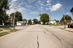
Ulen is a town in Center Township, Boone County, in the U.S. state of Indiana. The population was 117 at the 2010 census. The town is surrounded by the city of Lebanon.

Albany is a town in Delaware and Randolph counties in the U.S. state of Indiana, along the Mississinewa River. The population was 2,295 at the 2020 census. It is part of the Muncie, IN Metropolitan Statistical Area.

Blountsville is a town in Stoney Creek Township, Henry County, Indiana, United States. The population was 98 at the 2020 census.

Cadiz is a town in Harrison Township, Henry County, Indiana, United States. The population was 150 at the 2010 census.

Dunreith is a town in Spiceland Township, Henry County, Indiana, United States. The population was 177 at the 2010 census.

Greensboro is a town in Greensboro Township, Henry County, Indiana, United States. The population was 143 at the 2010 census. The town was a 'station' on the Underground Railroad and was recognized for its active abolitionists.

Knightstown is a town in Wayne Township, Henry County, Indiana, adjacent to Rush County, along the Big Blue River. The population was 2,182 at the 2010 census. It is approximately thirty-two miles east of Indianapolis.

Lewisville is a town in Franklin Township, Henry County, Indiana, United States. The population was 366 at the 2010 census.

Middletown is a town in northwest Henry County, Indiana, United States. The population was 2,322 at the 2010 census.

Mount Summit is a town in Prairie Township, Henry County, Indiana, United States. The population was 352 at the 2010 census.
Spiceland is a town in Spiceland Township, Henry County, Indiana, United States. The population was 890 at the 2010 census.

Springport is a town in Prairie Township, Henry County, Indiana, United States. The population was 149 at the 2010 census.

Straughn is a town in Dudley Township, Henry County, Indiana, United States. The population was 222 at the 2010 census.

Sulphur Springs is a town in Jefferson Township, Henry County, Indiana, United States. As of the 2010 census, the town's population was 399.

River Forest is a town in Anderson Township, Madison County, Indiana, United States. It is part of the Indianapolis–Carmel–Anderson metropolitan statistical area. The population was 26 at the 2020 census.

Woodlawn Heights is a town in Anderson Township, Madison County, Indiana, United States. It is part of the Indianapolis–Carmel–Anderson metropolitan statistical area. The population was 91 at the 2020 census.

Paragon is a town in Ray Township, Morgan County, in the U.S. state of Indiana. The population was 556 at the 2020 census, down from 659 in 2010.

Clear Lake is a town located in the northeast corner of Steuben County, Indiana, in Clear Lake Township. As such, is the northeasternmost community in the State of Indiana. The population was 339 at the 2010 census.

Whitewater is a town in Franklin Township, Wayne County, in the U.S. state of Indiana. The population was 83 at the 2010 census.

Mooreland is a town in Woodward County, Oklahoma, United States, 10 miles (16 km) east of the city of Woodward, the county seat. The population was 1,190 at the 2010 census. Mooreland lies in a valley approximately 5 miles (8.0 km) north of the North Canadian River. This area of shallow-water land lies at an altitude of 1,900 feet (580 m).