Straughn, Indiana

Last updated

Straughn, Indiana
Henry County Indiana Incorporated and Unincorporated areas Straughn Highlighted 1873664.svg
Location of Straughn in Henry County, Indiana.
Coordinates: 39°48′30″N85°17′27″W / 39.80833°N 85.29083°W / 39.80833; -85.29083
Country United States
State Indiana
County Henry
Township Dudley
Area
[1]
  Total0.14 sq mi (0.37 km2)
  Land0.14 sq mi (0.37 km2)
  Water0.00 sq mi (0.00 km2)
Elevation
[2]
1,079 ft (329 m)
Population
 (2020)
  Total259
  Density1,836.88/sq mi (708.85/km2)
Time zone UTC-5 (Eastern (EST))
  Summer (DST) UTC-4 (EDT)
ZIP code
47387
Area code 765
FIPS code 18-73664 [3]
GNIS feature ID2397685 [2]

Straughn is a town in Dudley Township, Henry County, Indiana, United States. The population was 222 at the 2010 census.

Contents

History

Straughn was platted in 1868. [4] It was named for Merriman Straughn, a pioneer settler. [4]

Geography

According to the 2010 census, Straughn has a total area of 0.14 square miles (0.36 km2), all land. [5]

Demographics

Historical population
CensusPop.Note
1880 143
1890 20039.9%
1900 186−7.0%
1910 23425.8%
1920 26111.5%
1930 212−18.8%
1940 27529.7%
1950 34525.5%
1960 3491.2%
1970 329−5.7%
1980 3310.6%
1990 318−3.9%
2000 263−17.3%
2010 222−15.6%
2020 25916.7%
U.S. Decennial Census [6]

2010 census

As of the census [7] of 2010, there were 222 people, 81 households, and 61 families living in the town. The population density was 1,585.7 inhabitants per square mile (612.2/km2). There were 97 housing units at an average density of 692.9 per square mile (267.5/km2). The racial makeup of the town was 99.5% White and 0.5% from other races. Hispanic or Latino of any race were 0.5% of the population.

There were 81 households, of which 32.1% had children under the age of 18 living with them, 55.6% were married couples living together, 18.5% had a female householder with no husband present, 1.2% had a male householder with no wife present, and 24.7% were non-families. 22.2% of all households were made up of individuals, and 9.9% had someone living alone who was 65 years of age or older. The average household size was 2.74 and the average family size was 3.20.

The median age in the town was 40 years. 22.1% of residents were under the age of 18; 12.7% were between the ages of 18 and 24; 25.3% were from 25 to 44; 25.3% were from 45 to 64; and 14.9% were 65 years of age or older. The gender makeup of the town was 43.7% male and 56.3% female.

2000 census

As of the census [3] of 2000, there were 263 people, 94 households, and 73 families living in the town. The population density was 1,882.2 inhabitants per square mile (726.7/km2). There were 103 housing units at an average density of 737.1 per square mile (284.6/km2). The racial makeup of the town was 99.62% White, and 0.38% from other races. Hispanic or Latino of any race were 0.38% of the population.

There were 94 households, out of which 38.3% had children under the age of 18 living with them, 67.0% were married couples living together, 6.4% had a female householder with no husband present, and 22.3% were non-families. 21.3% of all households were made up of individuals, and 12.8% had someone living alone who was 65 years of age or older. The average household size was 2.80 and the average family size was 3.30.

In the town, the population was spread out, with 27.4% under the age of 18, 9.1% from 18 to 24, 28.9% from 25 to 44, 20.2% from 45 to 64, and 14.4% who were 65 years of age or older. The median age was 34 years. For every 100 females, there were 83.9 males. For every 100 females age 18 and over, there were 91.0 males.

The median income for a household in the town was $31,944, and the median income for a family was $33,906. Males had a median income of $27,500 versus $16,250 for females. The per capita income for the town was $13,693. About 11.1% of families and 15.3% of the population were below the poverty line, including 26.6% of those under the age of eighteen and 5.3% of those 65 or over.

Related Research Articles

<span class="mw-page-title-main">Blountsville, Indiana</span> Town in Indiana, United States

Blountsville is a town in Stoney Creek Township, Henry County, Indiana, United States. The population was 98 at the 2020 census.

<span class="mw-page-title-main">Cadiz, Indiana</span> Town in Indiana, United States

Cadiz is a town in Harrison Township, Henry County, Indiana, United States. The population was 150 at the 2010 census.

<span class="mw-page-title-main">Dunreith, Indiana</span> Town in Indiana, United States

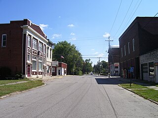
Dunreith is a town in Spiceland Township, Henry County, Indiana, United States. The population was 177 at the 2010 census.

<span class="mw-page-title-main">Greensboro, Indiana</span> Town in Indiana, United States

Greensboro is a town in Greensboro Township, Henry County, Indiana, United States. The population was 143 at the 2010 census. The town was a 'station' on the Underground Railroad and was recognized for its active abolitionists.

<span class="mw-page-title-main">Knightstown, Indiana</span> Town in Indiana, United States

Knightstown is a town in Wayne Township, Henry County, Indiana, adjacent to Rush County, along the Big Blue River. The population was 2,182 at the 2010 census. It is approximately thirty-two miles east of Indianapolis.

<span class="mw-page-title-main">Lewisville, Indiana</span> Town in Indiana, United States

Lewisville is a town in Franklin Township, Henry County, Indiana, United States. The population was 366 at the 2010 census.

<span class="mw-page-title-main">Middletown, Indiana</span> Town in Indiana, United States

Middletown is a town in northwest Henry County, Indiana, United States. The population was 2,322 at the 2010 census.

<span class="mw-page-title-main">Mooreland, Indiana</span> Town in Indiana, United States

Mooreland is a town in Blue River Township, Henry County, Indiana, United States. The population was 375 at the 2010 census.

<span class="mw-page-title-main">Mount Summit, Indiana</span> Town in Indiana, United States

Mount Summit is a town in Prairie Township, Henry County, Indiana, United States. The population was 352 at the 2010 census.

<span class="mw-page-title-main">Spiceland, Indiana</span> Town in Indiana, United States

Spiceland is a town in Spiceland Township, Henry County, Indiana, United States. The population was 890 at the 2010 census.

<span class="mw-page-title-main">Springport, Indiana</span> Town in Indiana, United States

Springport is a town in Prairie Township, Henry County, Indiana, United States. The population was 149 at the 2010 census.

<span class="mw-page-title-main">Sulphur Springs, Indiana</span> Town in Indiana, United States

Sulphur Springs is a town in Jefferson Township, Henry County, Indiana, United States. As of the 2010 census, the town's population was 399.

<span class="mw-page-title-main">Hammond, Maine</span> Town in the state of Maine, United States

Hammond is a town in Aroostook County, Maine, United States. The population was 91 at the 2020 census.

<span class="mw-page-title-main">Hersey, Maine</span> Town in the state of Maine, United States

Hersey is a town in Aroostook County, Maine, United States. The population was 73 at the 2020 census.

<span class="mw-page-title-main">Perham, Maine</span> Town in the state of Maine, United States

Perham is a town in Aroostook County, Maine, United States. The population was 371 at the 2020 census. The town was named after Maine's 33rd governor, Sidney Perham.

<span class="mw-page-title-main">Westfield, Maine</span> Town in the state of Maine, United States

Westfield is a town in Aroostook County, Maine, United States. The population was 455 at the 2020 census.

<span class="mw-page-title-main">Chesterville, Maine</span> Town in Maine, United States

Chesterville is a town in Franklin County, Maine, United States. The population was 1,328 at the 2020 census.

Stoneham is a town in Oxford County, Maine, United States. The population was 261 at the 2020 census.

Detroit is a town in Somerset County, Maine, United States. The population was 885 at the 2020 census.

<span class="mw-page-title-main">Camden-on-Gauley, West Virginia</span> Town in West Virginia, United States

Camden-on-Gauley is a town in Webster County, West Virginia, United States, along the Gauley River. The population was 126 at the 2020 census.

References

  1. "2020 U.S. Gazetteer Files". United States Census Bureau. Retrieved March 16, 2022.
  2. 1 2 U.S. Geological Survey Geographic Names Information System: Straughn, Indiana
  3. 1 2 "U.S. Census website". United States Census Bureau . Retrieved January 31, 2008.
  4. 1 2 Hazzard, George (1906). Hazzard's History of Henry County, Indiana, 1822-1906. G. Hazzard, author and publisher. p.  965.
  5. "G001 - Geographic Identifiers - 2010 Census Summary File 1". United States Census Bureau. Archived from the original on February 13, 2020. Retrieved July 25, 2015.
  6. "Census of Population and Housing". Census.gov. Retrieved June 4, 2015.
  7. "U.S. Census website". United States Census Bureau . Retrieved December 11, 2012.