Knightstown, Indiana

Last updated

Knightstown, Indiana
Town of Knightstown
Knightstown, Indiana.jpg
Henry County Indiana Incorporated and Unincorporated areas Knightstown Highlighted 1840266.svg
Location of Knightstown in Henry County, Indiana.
Coordinates: 39°47′45″N85°31′52″W / 39.79583°N 85.53111°W / 39.79583; -85.53111
Country United States
State Indiana
County Henry
Township Wayne
Area
[1]
  Total1.04 sq mi (2.69 km2)
  Land1.03 sq mi (2.67 km2)
  Water0.01 sq mi (0.02 km2)
Elevation
[2]
929 ft (283 m)
Population
 (2020)
  Total2,140
  Density2,077.67/sq mi (802.52/km2)
Time zone UTC-5 (EST)
  Summer (DST) UTC-4 (EDT [3] )
ZIP code
46148
Area code 765
FIPS code 18-40266 [4]
GNIS feature ID2396694 [2]
Website http://www.knightstownonline.com

Knightstown is a town in Wayne Township, Henry County, Indiana, adjacent to Rush County, along the Big Blue River. The population was 2,182 at the 2010 census. It is approximately thirty-two miles east of Indianapolis.

Contents

Knightstown was used in the 1986 film Hoosiers . The Hoosier Gym was used in the filming of the film. Knightstown hosts two annual festivals: Jubilee Days held in early-mid June and The Hoosier Fall Festival held in September. Knightstown also hosts an annual car show and a music series on the town square.

History

Knightstown was founded and platted by Waitsell M. Cary in 1827. It was named for Jonathan Knight, an engineer on the National Road and U.S. Congressman from Pennsylvania. [5] [6] A post office has operated in Knightstown since 1833. [7]

The Elias Hinshaw House, Knightstown Academy, and Knightstown Historic District are listed on the National Register of Historic Places. [8]

Geography

According to the 2010 census, Knightstown has a total area of 1.04 square miles (2.69 km2), of which 1.03 square miles (2.67 km2) (or 99.04%) is land and 0.01 square miles (0.03 km2) (or 0.96%) is water. [9]

Demographics

Historical population
CensusPop.Note
1870 1,528
1880 1,6709.3%
1890 1,86711.8%
1900 1,9424.0%
1910 2,0083.4%
1920 1,918−4.5%
1930 2,20915.2%
1940 2,3235.2%
1950 2,4867.0%
1960 2,4960.4%
1970 2,456−1.6%
1980 2,325−5.3%
1990 2,048−11.9%
2000 2,1484.9%
2010 2,1821.6%
2020 2,140−1.9%
U.S. Decennial Census [10]

2010 census

As of the census [11] of 2010, there were 2,182 people, 899 households, and 590 families living in the town. The population density was 2,118.4 inhabitants per square mile (817.9/km2). There were 1,001 housing units at an average density of 971.8 per square mile (375.2/km2). The racial makeup of the town was 98.0% White, 0.1% African American, 0.1% Native American, 0.1% Asian, 0.1% Pacific Islander, 0.4% from other races, and 1.1% from two or more races. Hispanic or Latino of any race were 0.6% of the population.

There were 899 households, of which 34.5% had children under the age of 18 living with them, 47.1% were married couples living together, 13.6% had a female householder with no husband present, 5.0% had a male householder with no wife present, and 34.4% were non-families. 28.8% of all households were made up of individuals, and 13.5% had someone living alone who was 65 years of age or older. The average household size was 2.43 and the average family size was 3.00.

The median age in the town was 38.8 years. 25.4% of residents were under the age of 18; 9.2% were between the ages of 18 and 24; 24.1% were from 25 to 44; 25.3% were from 45 to 64; and 16% were 65 years of age or older. The gender makeup of the town was 47.8% male and 52.2% female.

2000 census

As of the census [4] of 2000, there were 2,148 people, 915 households, and 595 families living in the town. The population density was 3,026.2 inhabitants per square mile (1,168.4/km2). There were 979 housing units at an average density of 1,379.2 per square mile (532.5/km2). The racial makeup of the town was 99.02% White, 0.42% African American, 0.09% Native American, 0.09% Asian, and 0.37% from two or more races. Hispanic or Latino of any race were 0.23% of the population.

Knightstown, Indiana from the air, looking southwest. Knightstown-indiana-from-above.jpg
Knightstown, Indiana from the air, looking southwest.

There were 915 households, out of which 31.3% had children under the age of 18 living with them, 50.9% were married couples living together, 10.4% had a female householder with no husband present, and 34.9% were non-families. 31.4% of all households were made up of individuals, and 16.4% had someone living alone who was 65 years of age or older. The average household size was 2.35 and the average family size was 2.93.

In the town, the population was spread out, with 25.7% under the age of 18, 7.1% from 18 to 24, 27.7% from 25 to 44, 22.2% from 45 to 64, and 17.3% who were 65 years of age or older. The median age was 37 years. For every 100 females, there were 85.0 males. For every 100 females age 18 and over, there were 82.1 males.

The median income for a household in the town was $35,639, and the median income for a family was $42,222. Males had a median income of $36,081 versus $22,111 for females. The per capita income for the town was $22,466. About 7.0% of families and 7.1% of the population were below the poverty line, including 8.6% of those under age 18 and 4.1% of those age 65 or over.

Education

Knightstown is served by the Charles A. Beard Memorial School Corporation. Knightstown High School offers AP and ACP (Advanced College Project) credits. High School Cheerleaders won the State Championship in 2000, 2004, 2005, 2012, 2013, 2014, 2015, 2016 and 2018. Knightstown also has an elementary school and an intermediate school.

The town has a lending library, the Knightstown Public Library. [12]

Notable people

Recreation

Related Research Articles

<span class="mw-page-title-main">Monroe, Adams County, Indiana</span> Town in Indiana, United States

Monroe is a town in Washington and Monroe townships, Adams County, Indiana, United States. The population of the town was 945 residents at the 2019 census. Adams Central Community Schools is located in Monroe.

<span class="mw-page-title-main">Marengo, Indiana</span> Town in Indiana, United States

Marengo is a town in Liberty Township, Crawford County, Indiana, United States. The population was 829 at the 2020 census. One of the tourist attractions and sources of revenue for the town is Marengo Cave, a U.S. National Landmark.

<span class="mw-page-title-main">Veedersburg, Indiana</span> Town in Indiana, United States

Veedersburg is a town in Van Buren Township, Fountain County, Indiana, United States. The population was 2,180 at the 2010 census.

<span class="mw-page-title-main">Wilkinson, Indiana</span> Town in Indiana, United States

Wilkinson is a town in Brown Township, Hancock County, Indiana, United States. The population was 449 at the 2010 census.

<span class="mw-page-title-main">Cadiz, Indiana</span> Town in Indiana, United States

Cadiz is a town in Harrison Township, Henry County, Indiana, United States. The population was 150 at the 2010 census.

<span class="mw-page-title-main">Dunreith, Indiana</span> Town in Indiana, United States

Dunreith is a town in Spiceland Township, Henry County, Indiana, United States. The population was 177 at the 2010 census.

<span class="mw-page-title-main">Greensboro, Indiana</span> Town in Indiana, United States

Greensboro is a town in Greensboro Township, Henry County, Indiana, United States. The population was 143 at the 2010 census. The town was a 'station' on the Underground Railroad and was recognized for its active abolitionists.

<span class="mw-page-title-main">Lewisville, Indiana</span> Town in Indiana, United States

Lewisville is a town in Franklin Township, Henry County, Indiana, United States. The population was 366 at the 2010 census.

<span class="mw-page-title-main">Middletown, Indiana</span> Town in Indiana, United States

Middletown is a town in northwest Henry County, Indiana, United States. The population was 2,322 at the 2010 census.

<span class="mw-page-title-main">Mooreland, Indiana</span> Town in Indiana, United States

Mooreland is a town in Blue River Township, Henry County, Indiana, United States. The population was 375 at the 2010 census.

<span class="mw-page-title-main">Mount Summit, Indiana</span> Town in Indiana, United States

Mount Summit is a town in Prairie Township, Henry County, Indiana, United States. The population was 352 at the 2010 census.

<span class="mw-page-title-main">Spiceland, Indiana</span> Town in Indiana, United States

Spiceland is a town in Spiceland Township, Henry County, Indiana, United States. The population was 890 at the 2010 census.

<span class="mw-page-title-main">Springport, Indiana</span> Town in Indiana, United States

Springport is a town in Prairie Township, Henry County, Indiana, United States. The population was 149 at the 2010 census.

<span class="mw-page-title-main">Straughn, Indiana</span> Town in Indiana, United States

Straughn is a town in Dudley Township, Henry County, Indiana, United States. The population was 222 at the 2010 census.

<span class="mw-page-title-main">Sulphur Springs, Indiana</span> Town in Indiana, United States

Sulphur Springs is a town in Jefferson Township, Henry County, Indiana, United States. As of the 2010 census, the town's population was 399.

<span class="mw-page-title-main">Brownstown, Indiana</span> Town in Indiana, United States

Brownstown is a town within Brownstown Township and the county seat of Jackson County, Indiana, United States. The population was 2,947 at the 2010 census. It was named for Jacob Brown, a general of the War of 1812.

<span class="mw-page-title-main">Topeka, Indiana</span> Town in Indiana, United States

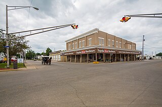
Topeka is a town in Clearspring and Eden townships, LaGrange County, Indiana, United States. The population was 1,153 at the 2010 census. Topeka is located approximately eleven miles south of Shipshewana, Indiana.

<span class="mw-page-title-main">Russellville, Indiana</span> Town in Indiana, United States

Russellville is a town in Russell Township, Putnam County, in the U.S. state of Indiana. The population was 358 at the 2010 census.

<span class="mw-page-title-main">Farmland, Indiana</span> Town in Indiana, United States

Farmland is a town in Monroe Township, Randolph County, in the U.S. state of Indiana. The population was 1,333 at the 2010 census.

<span class="mw-page-title-main">Carthage, Indiana</span> Town in Indiana, United States

Carthage is a town in Ripley Township, Rush County, Indiana, United States, located along the Big Blue River. The population was 927 at the 2010 census.

References

  1. "2020 U.S. Gazetteer Files". United States Census Bureau. Retrieved March 16, 2022.
  2. 1 2 U.S. Geological Survey Geographic Names Information System: Knightstown, Indiana
  3. Knightstown, Indiana Current Local Time. timetemperature.com
  4. 1 2 "U.S. Census website". United States Census Bureau . Retrieved January 31, 2008.
  5. Hazzard, George (1906). Hazzard's History of Henry County, Indiana, 1822–1906. G. Hazzard, author and publisher. pp.  934–936.
  6. Gannett, Henry (1905). The Origin of Certain Place Names in the United States. Government Printing Office. pp.  177.
  7. "Henry County". Jim Forte Postal History. Retrieved February 2, 2015.
  8. "National Register Information System". National Register of Historic Places . National Park Service. July 9, 2010.
  9. "G001 – Geographic Identifiers – 2010 Census Summary File 1". United States Census Bureau. Archived from the original on February 13, 2020. Retrieved July 17, 2015.
  10. "Census of Population and Housing". Census.gov. Retrieved June 4, 2015.
  11. "U.S. Census website". United States Census Bureau . Retrieved December 11, 2012.
  12. "Indiana public library directory" (PDF). Indiana State Library. Archived from the original (PDF) on February 18, 2017. Retrieved March 7, 2018.
  13. "Noted K.H.S. Grad's Death is Reported". Tri-County Banner. Knightstown, Indiana. January 19, 1961. p. 1.
  14. "My Site". www.thehoosiergym.com.
  15. "Welcome to Royal Hylands". Archived from the original on July 11, 2010. Retrieved February 14, 2010.