Paulding County is a county located in the northwestern part of the U.S. state of Georgia. Part of the Atlanta metropolitan area, it had an estimated population of 168,661 in 2020. The county seat is Dallas.

Henry County is located in the north central portion of the U.S. state of Georgia. According to the 2020 census, the population of Henry County was 240,712, up from 203,922 in 2010. The seat of government is McDonough. The county was named for Patrick Henry.

Hall County is a county located in the northeast portion of the U.S. state of Georgia. As of the 2020 census, the population was 203,136, up from 179,684 at the 2010 census. The county seat is Gainesville. The entirety of Hall County comprises the Gainesville, Georgia, Metropolitan Statistical Area, which is also part of the Atlanta-Athens-Clarke County-Sandy Springs, Combined Statistical Area.

Clayton County is located in the north central portion of the U.S. state of Georgia. As of 2021, the population was estimated to be 297,100 by the Census Bureau. The county seat is Jonesboro.

Bonanza is an unincorporated community and census-designated place (CDP) in Clayton County, Georgia, United States. The population was 3,135 at the 2010 census.

Conley is an unincorporated community and census-designated place (CDP) in Clayton County, Georgia, United States. It is at Atlanta's southeast corner, 7.98 miles from downtown. The population was 6,680 at the 2020 census. It is part of the Atlanta Metropolitan Area.
Forest Park is a city in Clayton County, Georgia, United States. It is located approximately nine miles (14 km) south of Atlanta and is part of the Atlanta–Sandy Springs–Marietta Metropolitan Statistical Area. As of the 2020 census, the city had a population of 19,932.
Irondale is an unincorporated community and census-designated place (CDP) in Clayton County, Georgia, United States. The population was 8,740 at the 2020 census.

Jonesboro is a city in and the county seat of Clayton County, Georgia, United States. The population was 4,724 as of the 2010 census.

Lake City is a city in Clayton County, Georgia, United States. The population was 2,612 at the 2010 census.
Lovejoy is a city in Clayton County, Georgia, United States. As of the 2010 census, the city had a population of 6,422, up from 2,495 in 2000. During the American Civil War, it was the site of the Battle of Lovejoy's Station during the Atlanta Campaign of 1864. Lovejoy was incorporated as a town on September 16, 1861.

Riverdale is a city in Clayton County, Georgia, United States. The population was 15,134 at the 2010 census, up from 12,478 in 2000. Riverdale is a suburb just south of Hartsfield–Jackson Atlanta International Airport and is part of the Atlanta metropolitan area.

Moreland is a town in Coweta County, Georgia, United States. As of the 2020 census, the town population was 382.

Tyrone is a town in Fayette County, Georgia, United States. The population was 6,879 at the 2010 census, up from 3,916 in 2000. The estimated population in 2018 was 7,388. It is a part of the Atlanta metropolitan area.

Fairburn is a city in Fulton County, Georgia, United States, with a population of 12,950, according to the 2010 census. Though it has a rich history of its own, the city is now a closely linked suburb of Atlanta, which lies just 17 miles to the north.

Lilburn is a city in Gwinnett County, Georgia, United States. The population was 14,502 at the 2020 census. The estimated population was 12,810 in 2019. It is a part of the Atlanta metropolitan area.

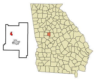
Hampton is a city in southwestern Henry County, Georgia, United States. The 2020 census was 8,368. As of the 2010 census, the city had a population of 6,987, up from 3,857 at the 2000 census. By 2018 the estimated population was 7,922. "Hampton" mailing addresses outside the city limits reach into rural parts of eastern Clayton County and northern Spalding County. It is a southeastern suburb in the Atlanta metropolitan area.
Milner is a city in Lamar County, Georgia, United States. The population was 610 at the 2010 census, up from 522 at the 2000 census. Milner is part of Metro Atlanta.

Jasper is a city in Pickens County, Georgia, United States. The population was 3,684 at the 2010 census. The city is the county seat of Pickens County.

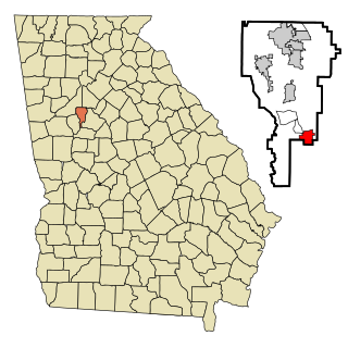
Locust Grove is a city in Henry County, Georgia, United States. The population was 5,402 at the 2010 census, up from 2,322 in 2000. Some unincorporated communities such as Luella and many rural areas surround Locust Grove, and those communities have Locust Grove postal addresses.