Naplate, Illinois

Last updated

Naplate, Illinois
LaSalle County Illinois Incorporated and Unincorporated areas Naplate Highlighted.svg
Location in LaSalle County, Illinois
Illinois in United States (US48).svg
Location of Illinois in the United States
Coordinates: 41°19′54″N88°52′49″W / 41.33167°N 88.88028°W / 41.33167; -88.88028 [1]
CountryUnited States
StateIllinois
County LaSalle
Township Ottawa
Government
  Village presidentGary Mooney
Area
[2]
  Total0.16 sq mi (0.41 km2)
  Land0.16 sq mi (0.41 km2)
  Water0.00 sq mi (0.00 km2)
Elevation
[1]
482 ft (147 m)
Population
 (2020)
  Total412
  Density2,575.00/sq mi (997.05/km2)
Time zone UTC-6 (CST)
  Summer (DST) UTC-5 (CDT)
ZIP Code(s)
61350
Area code 815
FIPS code 17-51648
GNIS feature ID2399435 [1]
Wikimedia CommonsNaplate, Illinois
Website https://villageofnaplate.com/

Naplate is a village in LaSalle County, Illinois, United States. The population was 412 at the 2020 census. It is part of the Ottawa Micropolitan Statistical Area.

Contents

History

The name Naplate was created at the time of incorporation by combining the name of the primary employer, National Plate Glass Company into Naplate.

Geography

Naplate is located in central LaSalle County at 41°19′53″N88°52′44″W / 41.33139°N 88.87889°W / 41.33139; -88.87889 (41.331269, -88.878932). [3] According to the 2021 census gazetteer files, Naplate has a total area of 0.16 square miles (0.41 km2), all land. [4]

Naplate lies on the north bank of the Illinois River just downstream from Ottawa. [5] [6] Buffalo Rock State Park and Starved Rock State Park lie along the river just west and southwest of Naplate. [6]

Demographics

Historical population
CensusPop.Note
1950 783
1960 738−5.7%
1970 686−7.0%
1980 581−15.3%
1990 6094.8%
2000 523−14.1%
2010 496−5.2%
2020 412−16.9%
U.S. Decennial Census [7]

As of the 2020 census [8] there were 412 people, 231 households, and 120 families residing in the village. The population density was 2,575.00 inhabitants per square mile (994.21/km2). There were 241 housing units at an average density of 1,506.25 per square mile (581.57/km2). The racial makeup of the village was 86.41% White, 1.70% African American, 1.46% Native American, 0.24% Asian, 1.70% from other races, and 8.50% from two or more races. Hispanic or Latino of any race were 7.52% of the population.

There were 231 households, out of which 20.8% had children under the age of 18 living with them, 28.57% were married couples living together, 15.15% had a female householder with no husband present, and 48.05% were non-families. 41.56% of all households were made up of individuals, and 20.35% had someone living alone who was 65 years of age or older. The average household size was 2.50 and the average family size was 1.91.

The village's age distribution consisted of 12.2% under the age of 18, 10.4% from 18 to 24, 19.7% from 25 to 44, 35.8% from 45 to 64, and 21.9% who were 65 years of age or older. The median age was 51.5 years. For every 100 females, there were 104.6 males. For every 100 females age 18 and over, there were 99.0 males.

The median income for a household in the village was $45,673, and the median income for a family was $63,333. Males had a median income of $35,000 versus $23,750 for females. The per capita income for the village was $28,150. About 1.7% of families and 10.0% of the population were below the poverty line, including 9.3% of those under age 18 and 13.4% of those age 65 or over.

Related Research Articles

<span class="mw-page-title-main">Mulberry Grove, Illinois</span> Village in Illinois, United States

Mulberry Grove is a village in eastern Bond County, Illinois, United States. The population was 520 at the 2020 census.

<span class="mw-page-title-main">Dalzell, Illinois</span> Village in Illinois, United States

Dalzell is a village in Bureau and LaSalle counties in the U.S. state of Illinois. The population was 663 at the 2020 census, down from 717 at the 2010 census. It is part of the Ottawa Micropolitan Statistical Area. Dalzell was founded on November 24, 1903, and certified on February 11, 1904.

<span class="mw-page-title-main">Seatonville, Illinois</span> Village in Illinois, United States

Seatonville is a village in Bureau County, Illinois, United States. The population was 321 at the 2020 census. It is part of the Ottawa Micropolitan Statistical Area.

<span class="mw-page-title-main">Somonauk, Illinois</span> Village in Illinois, United States

Somonauk is a village in DeKalb and LaSalle Counties in the U.S. state of Illinois. The population was 1,786 at the 2020 Census, down from 1,893 at the 2010 Census.

<span class="mw-page-title-main">Thompsonville, Illinois</span> Village in Illinois, United States

Thompsonville is a village in Cave Township, Franklin County, Illinois, United States. The population was 486 at the 2020 census.

<span class="mw-page-title-main">Carbon Hill, Illinois</span> Village in Illinois, United States

Carbon Hill is a village in Grundy County, Illinois, United States. The population was 372 at the 2020 census.

<span class="mw-page-title-main">Seneca, Illinois</span> Village in Illinois, United States

Seneca is a village in LaSalle and Grundy counties in the U.S. state of Illinois. The population was 2,353 at the 2020 census, down from 2,371 at the 2010 census.

<span class="mw-page-title-main">Lisbon, Illinois</span> Village in Illinois, United States

Lisbon is a village in Kendall County, Illinois, United States. The population was 271 at the 2020 census.

<span class="mw-page-title-main">Millington, Illinois</span> Village in Illinois, United States

Millington is a village in Kendall and LaSalle counties in the U.S. state of Illinois. The population was 617 at the 2020 census, down from 665 at the 2010 census.

<span class="mw-page-title-main">Cedar Point, Illinois</span> Village in Illinois, United States

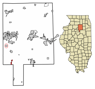
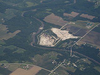
Cedar Point is a village in LaSalle County, Illinois, United States. The population was 266 at the 2020 census, down from 277 at the 2010 census. It is part of the Ottawa Micropolitan Statistical Area. North of town was the Cedar Point Mine, which operated from 1906 to 1924.

<span class="mw-page-title-main">Dana, Illinois</span> Village in Illinois, United States

Dana is a village in LaSalle County, Illinois, United States. As of the 2010 census, the village had a total population of 159, down from 171 in 2000. It is part of the Ottawa Micropolitan Statistical Area, as well as a part of the geographic region known as Streatorland.

<span class="mw-page-title-main">Leland, Illinois</span> Village in Illinois, United States

Leland is a village in LaSalle County, Illinois, United States. The population was 951 at the 2020 census. It is part of the Ottawa Micropolitan Statistical Area.

<span class="mw-page-title-main">Lostant, Illinois</span> Village in Illinois, United States

Lostant is a village in LaSalle County, Illinois, United States. The population was 423 at the 2020 census, down from 498 at the 2010 census. It is part of the Ottawa Micropolitan Statistical Area.

<span class="mw-page-title-main">North Utica, Illinois</span> Village in Illinois, United States

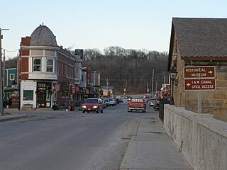
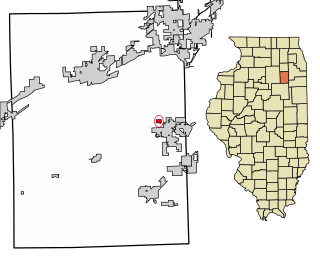
North Utica, often known as Utica, is a village in Utica Township, LaSalle County, Illinois. The population was 1,323 at the 2020 census. It is part of the Ottawa Micropolitan Statistical Area.

<span class="mw-page-title-main">Rutland, Illinois</span> Village in Illinois, United States

Rutland is a village in LaSalle County, Illinois, United States. It is part of the Ottawa Micropolitan Statistical Area. As of the 2020 census, the population was 259, down from 318 at the 2010 census.

<span class="mw-page-title-main">Tonica, Illinois</span> Village in LaSalle County, Illinois

Tonica is a village in LaSalle County, Illinois, United States. The population was 749 at the 2020 census, down from 768 at the 2010 census. It is part of the Ottawa Micropolitan Statistical Area.

<span class="mw-page-title-main">Compton, Illinois</span> Village in Illinois, United States

Compton is a village in Brooklyn Township, Lee County, Illinois, United States. The population was 303 at the 2010 census, down from 347 in 2000.

<span class="mw-page-title-main">Springerton, Illinois</span> Village in Illinois, United States

Springerton is a village in White County, Illinois, United States. The population was 134 at the 2000 census.

<span class="mw-page-title-main">Darlington, Missouri</span> Village in Missouri, United States

Darlington is a village in central Gentry County, Missouri, United States. The population was 66 at the 2020 census.

Dayton is a census-designated place in LaSalle County, Illinois, United States. The community was built along the Fox River a few miles north of Ottawa. As of the 2020 Census, its population was 528.

References

  1. 1 2 3 U.S. Geological Survey Geographic Names Information System: Naplate, Illinois
  2. "2020 U.S. Gazetteer Files". United States Census Bureau. Retrieved March 15, 2022.
  3. "US Gazetteer files: 2010, 2000, and 1990". United States Census Bureau. February 12, 2011. Retrieved April 23, 2011.
  4. Bureau, US Census. "Gazetteer Files". Census.gov. Retrieved June 29, 2022.
  5. Ottawa, Illinois 7.5 Minute Topographic Quadrangle, USGS, 1994
  6. 1 2 Starved Rock, Illinois 7.5 Minute Topographic Quadrangle, USGS, 1970
  7. "Census of Population and Housing". Census.gov. Retrieved June 4, 2015.
  8. "Explore Census Data". data.census.gov. Retrieved June 28, 2022.