National Register of Historic Places listings in Baxter County, Arkansas

Last updated

Location of Baxter County in Arkansas Map of Arkansas highlighting Baxter County.svg
Location of Baxter County in Arkansas

This is a list of the National Register of Historic Places listings in Baxter County, Arkansas.

Contents

This is intended to be a complete list of the properties and districts on the National Register of Historic Places in Baxter County, Arkansas, United States. The locations of National Register properties and districts for which the latitude and longitude coordinates are included below, may be seen in a map. [1]

There are 20 properties and districts listed on the National Register in the county.

Contents: Counties in Arkansas


    This National Park Service list is complete through NPS recent listings posted February 25, 2022. [2]

Map all coordinates using: OpenStreetMap  
Download coordinates as: KML

Current listings

[3] Name on the Register [4] ImageDate listed [5] Location City or townDescription
1 Baxter County Courthouse
Baxter County Courthouse Baxter County Arkansas Courthouse.JPG
Baxter County Courthouse
May 26, 1995
(#95000658)
Courthouse Sq.
36°20′07″N92°23′05″W / 36.3353°N 92.3847°W / 36.3353; -92.3847 (Baxter County Courthouse)
Mountain Home
2 Big Flat School Gymnasium
Big Flat School Gymnasium Big Flat School Gymnasium.JPG
Big Flat School Gymnasium
November 19, 1993
(#93001255)
County Road 121 south of its junction with Highway 14
36°00′10″N92°24′17″W / 36.0028°N 92.4047°W / 36.0028; -92.4047 (Big Flat School Gymnasium)
Big Flat
3 Buford School Building
Buford School Building Buford School Building.JPG
Buford School Building
September 4, 1992
(#92001128)
Highway 126
36°14′55″N92°25′38″W / 36.2486°N 92.4272°W / 36.2486; -92.4272 (Buford School Building)
Buford
4 Case-Shiras-Dearmore House
Case-Shiras-Dearmore House Case Shiras Dearmore House NRHP 91000580 Baxter County, AR.jpg
Case-Shiras-Dearmore House
February 3, 1992
(#91000580)
351 E. 4th St.
36°20′13″N92°22′53″W / 36.3369°N 92.3814°W / 36.3369; -92.3814 (Case-Shiras-Dearmore House)
Mountain Home
5 Casey House
Casey House Casey House.JPG
Casey House
December 4, 1975
(#75000374)
Fairgrounds off U.S. Highway 62
36°19′26″N92°22′56″W / 36.3239°N 92.3822°W / 36.3239; -92.3822 (Casey House)
Mountain Home
6 Cold Water School
Cold Water School Cold Water School.jpg
Cold Water School
May 29, 2008
(#08000485)
2422 County Road 73
36°08′26″N92°15′58″W / 36.1406°N 92.2661°W / 36.1406; -92.2661 (Cold Water School)
Big Flat
7 Cotter Bridge
Cotter Bridge Cotter Bridge.jpg
Cotter Bridge
April 4, 1990
(#90000518)
U.S. Highway 62B over the White River
36°16′03″N92°32′50″W / 36.2675°N 92.5472°W / 36.2675; -92.5472 (Cotter Bridge)
Cotter
8 Old Cotter High School Gymnasium
Old Cotter High School Gymnasium Old Cotter High School Gymnasium.JPG
Old Cotter High School Gymnasium
September 29, 1995
(#95001147)
412 Powell St.
36°16′14″N92°32′09″W / 36.2706°N 92.5358°W / 36.2706; -92.5358 (Old Cotter High School Gymnasium)
Cotter
9 Cotter Water Tower
Cotter Water Tower Cotter Water Tower.JPG
Cotter Water Tower
January 24, 2007
(#06001280)
Northeast of the junction of U.S. Highway 62B and State St.
36°16′34″N92°31′46″W / 36.2761°N 92.5294°W / 36.2761; -92.5294 (Cotter Water Tower)
Cotter
10 Davis House
Davis House Davis House, Calico Rock, AR.JPG
Davis House
March 23, 1995
(#95000271)
Southeastern corner of the junction of Wolf Street and Highway 5
36°12′35″N92°17′10″W / 36.2097°N 92.2861°W / 36.2097; -92.2861 (Davis House)
Norfork
11 Fort Smith to Jackson Road-Talbert's Ferry Segments September 22, 2004
(#04001030)
Address Restricted
Cotter Segments of the Trail of Tears [6]
12 Galatia Church September 8, 2020
(#100005579)
West side AR 5, north of jct. with Havner Rd.
36°11′28″N92°14′32″W / 36.1912°N 92.2422°W / 36.1912; -92.2422 (Galatia Church)
Norfork vicinity
13 Horace Mann School Historic District
Horace Mann School Historic District Horace Mann School Historic District, 1 of 4.JPG
Horace Mann School Historic District
January 29, 2007
(#06001311)
City Hall Circle
36°12′19″N92°17′02″W / 36.2053°N 92.2839°W / 36.2053; -92.2839 (Horace Mann School Historic District)
Norfork
14 Sid Hutcheson Building
Sid Hutcheson Building Sid Hutcheson Building.JPG
Sid Hutcheson Building
September 30, 2014
(#14000789)
13912 AR 5, S.
36°12′31″N92°17′12″W / 36.2087°N 92.2867°W / 36.2087; -92.2867 (Sid Hutcheson Building)
Norfork
15 Mountain Home Cemetery, Historic Section February 13, 2020
(#100004895)
147 East 11th St.
36°19′45″N92°23′04″W / 36.3291°N 92.3844°W / 36.3291; -92.3844 (Mountain Home Cemetery, Historic Section)
Mountain Home
16 Mountain Home Commercial Historic District
Mountain Home Commercial Historic District East Side of Mountain Home square.JPG
Mountain Home Commercial Historic District
June 15, 2010
(#10000348)
Roughly bounded on the north by East 5th St., East 9th St. on the south, South St. on the east, and Hickory St. on the west
36°20′04″N92°23′04″W / 36.3344°N 92.3845°W / 36.3344; -92.3845 (Mountain Home Commercial Historic District)
Mountain Home
17 Old Joe May 4, 1982
(#82002094)
Address Restricted
Norfork
18 Rollins Hospital
Rollins Hospital Rollins Hospital.JPG
Rollins Hospital
September 20, 2007
(#07000970)
107 E. Main St.
36°16′58″N92°29′40″W / 36.2828°N 92.4944°W / 36.2828; -92.4944 (Rollins Hospital)
Gassville
19 Wolf Cemetery
Wolf Cemetery Wolf Cemetery.jpg
Wolf Cemetery
March 13, 2013
(#13000063)
County Road 68
36°09′43″N92°15′28″W / 36.1620°N 92.2577°W / 36.1620; -92.2577 (Wolf Cemetery)
Norfork
20 Jacob Wolf House
Jacob Wolf House Wolf THREE.jpg
Jacob Wolf House
April 13, 1973
(#73000380)
On Highway 5, west of the fork of the White and North Fork Rivers
36°12′37″N92°17′11″W / 36.2103°N 92.2864°W / 36.2103; -92.2864 (Jacob Wolf House)
Norfork

Former listings

[3] Name on the RegisterImageDate listedDate removedLocationCity or townDescription
1 North Fork Bridge
North Fork Bridge North Fork Bridge.jpg
North Fork Bridge
April 9, 1990
(#90000512)
September 29, 2015 Highway 5, over the North Fork of the White River (North Fork River)
36°12′49″N92°17′11″W / 36.2136°N 92.2864°W / 36.2136; -92.2864 (North Fork Bridge)
Norfork

See also

Related Research Articles

National Register of Historic Places listings in Conway County, Arkansas

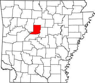
This is a list of the National Register of Historic Places listings in Conway County, Arkansas.

National Register of Historic Places listings in Carroll County, Arkansas

This is a list of the National Register of Historic Places listings in Carroll County, Arkansas.

National Register of Historic Places listings in Drew County, Arkansas

This is a list of the National Register of Historic Places listings in Drew County, Arkansas.

National Register of Historic Places listings in Desha County, Arkansas

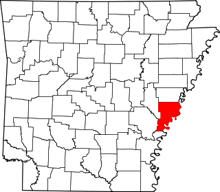
This is a list of the National Register of Historic Places listings in Desha County, Arkansas.

National Register of Historic Places listings in Cross County, Arkansas

This is a list of the National Register of Historic Places listings in Cross County, Arkansas.

National Register of Historic Places listings in Faulkner County, Arkansas

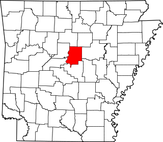
This is a list of the National Register of Historic Places listings in Faulkner County, Arkansas.

National Register of Historic Places listings in Crawford County, Arkansas

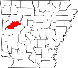
This is a list of the National Register of Historic Places listings in Crawford County, Arkansas.

National Register of Historic Places listings in Craighead County, Arkansas

This is a list of the National Register of Historic Places listings in Craighead County, Arkansas.

National Register of Historic Places listings in Garland County, Arkansas

This is a list of the National Register of Historic Places listings in Garland County, Arkansas.

National Register of Historic Places listings in Dallas County, Arkansas

This is a list of the National Register of Historic Places listings in Dallas County, Arkansas.

National Register of Historic Places listings in Independence County, Arkansas

This is a list of the National Register of Historic Places listings in Independence County, Arkansas.

National Register of Historic Places listings in Lonoke County, Arkansas

This is a list of the National Register of Historic Places listings in Lonoke County, Arkansas.

National Register of Historic Places listings in Logan County, Arkansas

This is a list of the National Register of Historic Places listings in Logan County, Arkansas.

National Register of Historic Places listings in Phillips County, Arkansas

This is a list of the National Register of Historic Places listings in Phillips County, Arkansas.

National Register of Historic Places listings in St. Francis County, Arkansas

This is a list of the National Register of Historic Places listings in St. Francis County, Arkansas.

National Register of Historic Places listings in Polk County, Arkansas

This is a list of the National Register of Historic Places listings in Polk County, Arkansas.

National Register of Historic Places listings in Pope County, Arkansas

This is a list of the National Register of Historic Places listings in Pope County, Arkansas.

National Register of Historic Places listings in Searcy County, Arkansas

This is a list of the National Register of Historic Places listings in Searcy County, Arkansas.

National Register of Historic Places listings in Stone County, Arkansas

This is a list of the National Register of Historic Places listings in Stone County, Arkansas.

National Register of Historic Places listings in White County, Arkansas

This is a list of the National Register of Historic Places listings in White County, Arkansas.

References

  1. The latitude and longitude information provided in this table was derived originally from the National Register Information System, which has been found to be fairly accurate for about 99% of listings. Some locations in this table may have been corrected to current GPS standards.
  2. National Park Service, United States Department of the Interior, "National Register of Historic Places: Weekly List Actions", retrieved February 25, 2022.
  3. 1 2 Numbers represent an alphabetical ordering by significant words. Various colorings, defined here, differentiate National Historic Landmarks and historic districts from other NRHP buildings, structures, sites or objects.
  4. "National Register Information System". National Register of Historic Places . National Park Service. March 13, 2009.
  5. The eight-digit number below each date is the number assigned to each location in the National Register Information System database, which can be viewed by clicking the number.
  6. "Trail Of Tears National Historic Trail: National Register Research". National Park Service. Retrieved January 22, 2013.