National Register of Historic Places listings in Desha County, Arkansas

Last updated

Location of Desha County in Arkansas Map of Arkansas highlighting Desha County.svg
Location of Desha County in Arkansas

This is a list of the National Register of Historic Places listings in Desha County, Arkansas.

Contents

This is intended to be a complete list of the properties and districts on the National Register of Historic Places in Desha County, Arkansas, United States. The locations of National Register properties and districts for which the latitude and longitude coordinates are included below, may be seen on a map. [1]

There are 27 properties and districts listed on the National Register in the county, including 1 National Historic Landmark.

Contents: Counties in Arkansas


    This National Park Service list is complete through NPS recent listings posted March 10, 2023. [2]

Map all coordinates using: OpenStreetMap  
Download coordinates as: KML

Current listings

[3] Name on the Register [4] ImageDate listed [5] Location City or townDescription
1 Arkansas City Commercial District
Arkansas City Commercial District Arkansas City Commercial District.jpg
Arkansas City Commercial District
February 18, 1999
(#99000227)
Roughly along the junction of Desoto Ave. and Sprague St.
33°36′19″N91°12′13″W / 33.605278°N 91.203611°W / 33.605278; -91.203611 (Arkansas City Commercial District)
Arkansas City
2 Arkansas City High School
Arkansas City High School Arkansas City High School 003.jpg
Arkansas City High School
October 4, 1984
(#84000005)
Robert S. Moore and President Sts.
33°36′36″N91°12′05″W / 33.61°N 91.201389°W / 33.61; -91.201389 (Arkansas City High School)
Arkansas City
3 Dante House January 23, 2020
(#100004905)
501 Court St.
33°52′56″N91°29′18″W / 33.8821°N 91.4884°W / 33.8821; -91.4884 (Dante House)
Dumas
4 Desha County Courthouse
Desha County Courthouse Desha County Courthouse 001.jpg
Desha County Courthouse
July 12, 1976
(#76000403)
Robert S. Moore Ave.
33°36′33″N91°12′08″W / 33.609167°N 91.202222°W / 33.609167; -91.202222 (Desha County Courthouse)
Arkansas City
5 Dickinson-Moore House
Dickinson-Moore House Dickinson-Moore House.jpg
Dickinson-Moore House
February 1, 2011
(#10001192)
707 Robert S. Moore Ave.
33°36′31″N91°12′10″W / 33.608611°N 91.202778°W / 33.608611; -91.202778 (Dickinson-Moore House)
Arkansas City
6 Dumas Commercial Historic District
Dumas Commercial Historic District Downtown Dumas 001.jpg
Dumas Commercial Historic District
May 22, 2007
(#07000446)
S. Main St. between Choctaw and Waterman Sts.
33°53′22″N91°29′32″W / 33.889444°N 91.492222°W / 33.889444; -91.492222 (Dumas Commercial Historic District)
Dumas
7 Hubert & Ionia Furr House
Hubert & Ionia Furr House Hubert & Ionia Furr House.jpg
Hubert & Ionia Furr House
February 4, 2011
(#10001197)
702 Desoto Ave.
33°36′24″N91°12′04″W / 33.606667°N 91.201111°W / 33.606667; -91.201111 (Hubert & Ionia Furr House)
Arkansas City
8 Kemp Cotton Gin Historic District
Kemp Cotton Gin Historic District Kemp Cotton Gin.jpg
Kemp Cotton Gin Historic District
June 1, 2005
(#05000491)
County Road 227 west of Highway 1
33°45′48″N91°16′36″W / 33.763333°N 91.276667°W / 33.763333; -91.276667 (Kemp Cotton Gin Historic District)
Rohwer
9 Jay Lewis House
Jay Lewis House Jay Lewis House.jpg
Jay Lewis House
January 20, 2005
(#04001501)
12 Fairview Dr.
33°38′13″N91°24′33″W / 33.636944°N 91.409167°W / 33.636944; -91.409167 (Jay Lewis House)
McGehee
10 McGehee City Jail
McGehee City Jail McGehee City Jail.jpg
McGehee City Jail
January 21, 2011
(#10001149)
Southwest corner of S. First St. and Pine St.
33°37′37″N91°23′45″W / 33.626944°N 91.395833°W / 33.626944; -91.395833 (McGehee City Jail)
McGehee
11 McGehee National Guard Armory
McGehee National Guard Armory McGehee National Guard Armory.JPG
McGehee National Guard Armory
May 31, 2006
(#06000441)
1610 S. 1st St.
33°36′48″N91°23′04″W / 33.613333°N 91.384444°W / 33.613333; -91.384444 (McGehee National Guard Armory)
McGehee
12 McGehee Post Office
McGehee Post Office McGehee Post Office 002.jpg
McGehee Post Office
January 19, 2010
(#09001245)
201 N. Second St.
33°37′44″N91°23′50″W / 33.628858°N 91.397089°W / 33.628858; -91.397089 (McGehee Post Office)
McGehee
13 McKennon-Shea House
McKennon-Shea House McKennon-Shea House 001.jpg
McKennon-Shea House
June 8, 1993
(#93000485)
206 Waterman St.
33°53′13″N91°29′39″W / 33.886944°N 91.494167°W / 33.886944; -91.494167 (McKennon-Shea House)
Dumas
14 Merchants & Farmers Bank
Merchants & Farmers Bank Downtown Dumas 004.jpg
Merchants & Farmers Bank
December 22, 1982
(#82000809)
Waterman and Main Sts.
33°53′15″N91°29′29″W / 33.8875°N 91.491389°W / 33.8875; -91.491389 (Merchants & Farmers Bank)
Dumas
15 Missouri Pacific Railroad Depot-McGehee
Missouri Pacific Railroad Depot-McGehee McGehee Train Stataion 001.jpg
Missouri Pacific Railroad Depot-McGehee
June 11, 1992
(#92000616)
Railroad St.
33°37′42″N91°23′42″W / 33.628333°N 91.395°W / 33.628333; -91.395 (Missouri Pacific Railroad Depot-McGehee)
McGehee
16 Missouri Pacific Railway Van Noy Eating House
Missouri Pacific Railway Van Noy Eating House McGehee Train Stataion 002.jpg
Missouri Pacific Railway Van Noy Eating House
January 24, 2011
(#10001154)
Southeast of the Seamans Dr. and Railroad St. intersection
33°37′41″N91°23′42″W / 33.628056°N 91.395°W / 33.628056; -91.395 (Missouri Pacific Railway Van Noy Eating House)
McGehee
17 Mound Cemetery
Mound Cemetery Old Mound Cemetery.jpg
Mound Cemetery
January 24, 2008
(#07001426)
0.5 miles north of Arkansas City on County Road 351
33°37′13″N91°12′03″W / 33.620278°N 91.200833°W / 33.620278; -91.200833 (Mound Cemetery)
Arkansas City
18 Old Piney Cemetery October 11, 2022
(#100008278)
US 278, approx. 2.7 miles (4.3 km) west of jct. with Cty. Rd. 74, 1/8 mi. north of US 287
Coordinates missing
Monticello
19 Parnell-Sharpe House
Parnell-Sharpe House Parnell-Sharpe House.jpg
Parnell-Sharpe House
September 28, 1989
(#89001594)
302 N. 2nd St.
33°37′51″N91°23′52″W / 33.630833°N 91.397778°W / 33.630833; -91.397778 (Parnell-Sharpe House)
McGehee
20 R.A. Pickens II House May 29, 2019
(#100003992)
1 Pickens Pl.
33°50′38″N91°28′53″W / 33.843889°N 91.481389°W / 33.843889; -91.481389 (R.A. Pickens II House)
Pickens
21 Xenophon Overton Pindall Law Office
Xenophon Overton Pindall Law Office Xenophon Overton Pindall Law Office.jpg
Xenophon Overton Pindall Law Office
May 10, 1999
(#98000832)
Junction of Capitol and Kate Adams Sts.
33°36′22″N91°12′11″W / 33.606111°N 91.203056°W / 33.606111; -91.203056 (Xenophon Overton Pindall Law Office)
Arkansas City
22 Rohwer Relocation Center Memorial Cemetery
Rohwer Relocation Center Memorial Cemetery Rohwer War Relocation Center 007.jpg
Rohwer Relocation Center Memorial Cemetery
July 6, 1992
(#92001882)
Highway 1
33°45′59″N91°16′49″W / 33.766389°N 91.280278°W / 33.766389; -91.280278 (Rohwer Relocation Center Memorial Cemetery)
Rohwer
23 Rohwer Relocation Center Site
Rohwer Relocation Center Site Rohwer Relocation Center, McGehee, Arkansas. Volunteer workers loading a truck from a boxcar for tr . . . - NARA - 538910.jpg
Rohwer Relocation Center Site
July 30, 1974
(#74000474)
Highway 1
33°45′58″N91°16′34″W / 33.766127°N 91.276156°W / 33.766127; -91.276156 (Rohwer Relocation Center Site)
Rohwer
24 Temple Meir Chayim
Temple Meir Chayim Temple Meir Chayim.jpg
Temple Meir Chayim
April 22, 1999
(#99000470)
Junction of 4th and Holly Sts.
33°37′43″N91°23′59″W / 33.628611°N 91.399722°W / 33.628611; -91.399722 (Temple Meir Chayim)
McGehee
25 Thane House
Thane House Thane House.jpg
Thane House
December 22, 1982
(#82000810)
Levy and 1st Sts.
33°36′26″N91°11′59″W / 33.607222°N 91.199722°W / 33.607222; -91.199722 (Thane House)
Arkansas City
26 Trippe Holly Grove Cemetery
Trippe Holly Grove Cemetery Holly Grove Cemetery.jpg
Trippe Holly Grove Cemetery
June 25, 1999
(#99000729)
Highway 4 or Crooked Bayou Rd., approximately 2 miles south of McGehee
33°36′07″N91°20′53″W / 33.601944°N 91.348056°W / 33.601944; -91.348056 (Trippe Holly Grove Cemetery)
McGehee
27 Dr. J.D. Watts House
Dr. J.D. Watts House Dr. J.D. Watts House 001.jpg
Dr. J.D. Watts House
December 9, 1994
(#94001460)
205 W. Choctaw
33°53′17″N91°29′39″W / 33.888056°N 91.494167°W / 33.888056; -91.494167 (Dr. J.D. Watts House)
Dumas

See also

Related Research Articles

<span class="mw-page-title-main">National Register of Historic Places listings in Clark County, Arkansas</span>

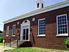
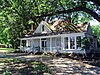
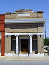
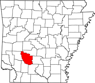
This is a list of the National Register of Historic Places listings in Clark County, Arkansas.

<span class="mw-page-title-main">National Register of Historic Places listings in Arkansas County, Arkansas</span>

This is a list of the National Register of Historic Places listings in Arkansas County, Arkansas.

<span class="mw-page-title-main">National Register of Historic Places listings in Cross County, Arkansas</span>

This is a list of the National Register of Historic Places listings in Cross County, Arkansas.

<span class="mw-page-title-main">National Register of Historic Places listings in Faulkner County, Arkansas</span>

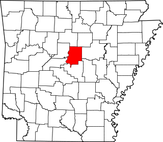
This is a list of the National Register of Historic Places listings in Faulkner County, Arkansas.

<span class="mw-page-title-main">National Register of Historic Places listings in Cleveland County, Arkansas</span>

This is a list of the National Register of Historic Places listings in Cleveland County, Arkansas.

<span class="mw-page-title-main">National Register of Historic Places listings in Garland County, Arkansas</span>

This is a list of the National Register of Historic Places listings in Garland County, Arkansas.

<span class="mw-page-title-main">National Register of Historic Places listings in Clay County, Arkansas</span>

This is a list of the National Register of Historic Places listings in Clay County, Arkansas.

<span class="mw-page-title-main">National Register of Historic Places listings in Madison County, Arkansas</span>

This is a list of the National Register of Historic Places listings in Madison County, Arkansas.

<span class="mw-page-title-main">National Register of Historic Places listings in Lee County, Arkansas</span>

This is a list of the National Register of Historic Places listings in Lee County, Arkansas.

<span class="mw-page-title-main">National Register of Historic Places listings in Lonoke County, Arkansas</span>

This is a list of the National Register of Historic Places listings in Lonoke County, Arkansas.

<span class="mw-page-title-main">National Register of Historic Places listings in Ouachita County, Arkansas</span>

This is a list of the National Register of Historic Places listings in Ouachita County, Arkansas.

<span class="mw-page-title-main">National Register of Historic Places listings in Phillips County, Arkansas</span>

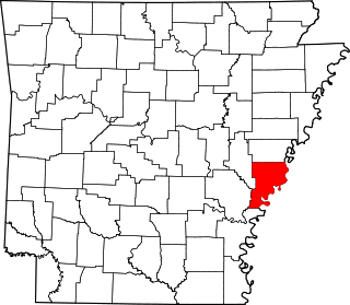
This is a list of the National Register of Historic Places listings in Phillips County, Arkansas.

<span class="mw-page-title-main">National Register of Historic Places listings in Pike County, Arkansas</span>

This is a list of the National Register of Historic Places listings in Pike County, Arkansas.

<span class="mw-page-title-main">National Register of Historic Places listings in Polk County, Arkansas</span>

This is a list of the National Register of Historic Places listings in Polk County, Arkansas.

<span class="mw-page-title-main">National Register of Historic Places listings in Randolph County, Arkansas</span>

This is a list of the National Register of Historic Places listings in Randolph County, Arkansas.

<span class="mw-page-title-main">National Register of Historic Places listings in Van Buren County, Arkansas</span>

This is a list of the National Register of Historic Places listings in Van Buren County, Arkansas.

<span class="mw-page-title-main">National Register of Historic Places listings in Union County, Arkansas</span>

This is a list of the National Register of Historic Places listings in Union County, Arkansas.

<span class="mw-page-title-main">National Register of Historic Places listings in Sebastian County, Arkansas</span>

This is a list of the National Register of Historic Places listings in Sebastian County, Arkansas.

<span class="mw-page-title-main">National Register of Historic Places listings in Stone County, Arkansas</span>

This is a list of the National Register of Historic Places listings in Stone County, Arkansas.

<span class="mw-page-title-main">National Register of Historic Places listings in White County, Arkansas</span>

This is a list of the National Register of Historic Places listings in White County, Arkansas.

References

  1. The latitude and longitude information provided in this table was derived originally from the National Register Information System, which has been found to be fairly accurate for about 99% of listings. Some locations in this table may have been corrected to current GPS standards.
  2. National Park Service, United States Department of the Interior, "National Register of Historic Places: Weekly List Actions", retrieved March 10, 2023.
  3. Numbers represent an alphabetical ordering by significant words. Various colorings, defined here, differentiate National Historic Landmarks and historic districts from other NRHP buildings, structures, sites or objects.
  4. "National Register Information System". National Register of Historic Places . National Park Service. March 13, 2009.
  5. The eight-digit number below each date is the number assigned to each location in the National Register Information System database, which can be viewed by clicking the number.