National Register of Historic Places listings in Pike County, Missouri

Last updated

Location of Pike County in Missouri Map of Missouri highlighting Pike County.svg
Location of Pike County in Missouri

This is a list of the National Register of Historic Places listings in Pike County, Missouri.

Contents

This is intended to be a complete list of the properties and districts on the National Register of Historic Places in Pike County, Missouri, United States. Latitude and longitude coordinates are provided for many National Register properties and districts; these locations may be seen together in a map. [1]

There are 21 properties and districts listed on the National Register in the county, including 1 National Historic Landmark.


    This National Park Service list is complete through NPS recent listings posted May 10, 2024. [2]

Current listings

[3] Name on the RegisterImageDate listed [4] Location City or townDescription
1 Charles Bacon House
Charles Bacon House The Charles Bacon House.jpg
Charles Bacon House
July 19, 1990
(#90001104)
819 Kentucky St.
39°26′57″N91°03′13″W / 39.449167°N 91.053611°W / 39.449167; -91.053611 (Charles Bacon House)
Louisiana
2 Capt. George and Attella Barnard House
Capt. George and Attella Barnard House Capt. George and Attella Barnard House.jpg
Capt. George and Attella Barnard House
March 31, 2000
(#00000309)
2009/2109 Georgia St.
39°26′32″N91°03′53″W / 39.442222°N 91.064722°W / 39.442222; -91.064722 (Capt. George and Attella Barnard House)
Louisiana
3 Bethel Chapel AME Church
Bethel Chapel AME Church Bethel Chapel AME Church Louisiana, Missouri.jpg
Bethel Chapel AME Church
July 28, 1995
(#95000926)
Junction of 6th and Tennessee Sts.
39°26′58″N91°03′02″W / 39.449444°N 91.050556°W / 39.449444; -91.050556 (Bethel Chapel AME Church)
Louisiana
4 City Market
City Market City Market Louisiana, Missouri.jpg
City Market
March 23, 2005
(#05000203)
125 S. Main St.
39°27′06″N91°02′46″W / 39.451667°N 91.046111°W / 39.451667; -91.046111 (City Market)
Louisiana
5 James Beauchamp Clark House
James Beauchamp Clark House Clark House.jpg
James Beauchamp Clark House
December 8, 1976
(#76001114)
204 E. Champ Clark Dr.
39°20′29″N91°11′27″W / 39.341389°N 91.190833°W / 39.341389; -91.190833 (James Beauchamp Clark House)
Bowling Green
6 Clarksville Historic District
Clarksville Historic District Clarksville, MO (41926311685).jpg
Clarksville Historic District
May 9, 1991
(#91000489)
Roughly bounded by Lewis, Front, Virginia and 3rd Sts.
39°22′11″N90°54′16″W / 39.369722°N 90.904444°W / 39.369722; -90.904444 (Clarksville Historic District)
Clarksville
7 Clifford-Wyrick House
Clifford-Wyrick House The Clifford-Wyrick House.jpg
Clifford-Wyrick House
July 9, 1984
(#84002600)
105 S. 2nd St.
39°22′13″N90°54′18″W / 39.370278°N 90.905°W / 39.370278; -90.905 (Clifford-Wyrick House)
Clarksville
8 Georgia Street Historic District
Georgia Street Historic District LA MO Masonic.JPG
Georgia Street Historic District
May 6, 1987
(#87000653)
Roughly Georgia St. between Main and Seventh Sts.
39°26′57″N91°02′56″W / 39.449167°N 91.048889°W / 39.449167; -91.048889 (Georgia Street Historic District)
Louisiana
9 Goodman-Stark House
Goodman-Stark House The Goodman-Stark House.jpg
Goodman-Stark House
October 22, 1994
(#94001205)
601 N. Third St.
39°27′14″N91°03′00″W / 39.453889°N 91.05°W / 39.453889; -91.05 (Goodman-Stark House)
Louisiana
10 Griffith-McCune Farmstead Historic District
Griffith-McCune Farmstead Historic District Rockford Farm.jpg
Griffith-McCune Farmstead Historic District
August 18, 1992
(#92001001)
MO WW E of junction with MO D
39°17′20″N90°58′17″W / 39.288889°N 90.971389°W / 39.288889; -90.971389 (Griffith-McCune Farmstead Historic District)
Eolia
11 Lock and Dam No. 24 Historic District
Lock and Dam No. 24 Historic District Lock and Dam No. 24 (42827418251).jpg
Lock and Dam No. 24 Historic District
March 10, 2004
(#04000183)
350 N. 1st St.
39°22′36″N90°54′30″W / 39.376667°N 90.908333°W / 39.376667; -90.908333 (Lock and Dam No. 24 Historic District)
Clarksville
12 Louisiana Chicago & Alton Railroad Depot
Louisiana Chicago & Alton Railroad Depot Louisiana Chicago & Alton Railroad Depot.jpg
Louisiana Chicago & Alton Railroad Depot
June 7, 2006
(#06000472)
801 S. Third St.
39°26′49″N91°02′38″W / 39.446944°N 91.043889°W / 39.446944; -91.043889 (Louisiana Chicago & Alton Railroad Depot)
Louisiana
13 Louisiana Public Library
Louisiana Public Library LA MO Library.JPG
Louisiana Public Library
April 12, 1996
(#96000401)
121 N. 3rd St.
39°27′02″N91°02′51″W / 39.450556°N 91.0475°W / 39.450556; -91.0475 (Louisiana Public Library)
Louisiana
14 Luce-Dyer House
Luce-Dyer House Luce-Dyer House.jpg
Luce-Dyer House
September 23, 1982
(#82003157)
220 N. 3rd St.
39°27′04″N91°02′54″W / 39.451111°N 91.048333°W / 39.451111; -91.048333 (Luce-Dyer House)
Louisiana
15 Meloan, Cummins & Co., General Store
Meloan, Cummins & Co., General Store Meloan, Cummings & Co. General Store.jpg
Meloan, Cummins & Co., General Store
June 24, 1993
(#93000571)
Junction of Middle and Water Sts., NW corner
39°15′45″N90°54′02″W / 39.2625°N 90.900556°W / 39.2625; -90.900556 (Meloan, Cummins & Co., General Store)
Paynesville
16 North Third Street Historic District
North Third Street Historic District LA MO N 3rd.JPG
North Third Street Historic District
August 24, 2005
(#05000912)
Roughly bounded by Georgia, Noyes, North Third and North Water Sts.
39°27′14″N91°02′56″W / 39.453889°N 91.048889°W / 39.453889; -91.048889 (North Third Street Historic District)
Louisiana
17 Northern Methodist Episcopal Church of Clarksville
Northern Methodist Episcopal Church of Clarksville Northern Methodist Episcopal Church of Clarksville.jpg
Northern Methodist Episcopal Church of Clarksville
May 9, 1991
(#91000487)
309 Smith St.
39°22′03″N90°54′14″W / 39.3675°N 90.903889°W / 39.3675; -90.903889 (Northern Methodist Episcopal Church of Clarksville)
Clarksville
18 Pike County Hospital
Pike County Hospital Pike County Hospital.jpg
Pike County Hospital
September 19, 2006
(#06000862)
2407 West Georgia St.
39°26′32″N91°03′52″W / 39.442222°N 91.064444°W / 39.442222; -91.064444 (Pike County Hospital)
Louisiana
19 St. John's Episcopal Church
St. John's Episcopal Church St John's Chutch 1.jpg
St. John's Episcopal Church
July 8, 1970
(#70000346)
0.25 miles N of Eolia on CR D, 0.25 miles E on CR H
39°14′58″N91°00′29″W / 39.249444°N 91.008056°W / 39.249444; -91.008056 (St. John's Episcopal Church)
Eolia
20 Gov. Lloyd Crow Stark House and Carriage House
Gov. Lloyd Crow Stark House and Carriage House LA MO Gov Stark House.JPG
Gov. Lloyd Crow Stark House and Carriage House
December 21, 1987
(#87002142)
1401 Georgia St.
39°26′40″N91°03′30″W / 39.444444°N 91.058333°W / 39.444444; -91.058333 (Gov. Lloyd Crow Stark House and Carriage House)
Louisiana
21 Turner-Pharr House
Turner-Pharr House The Turner-Pharrell House.jpg
Turner-Pharr House
May 9, 1991
(#91000488)
101 N. Fourth St.
39°22′11″N90°54′25″W / 39.369722°N 90.906944°W / 39.369722; -90.906944 (Turner-Pharr House)
Clarksville

See also

Related Research Articles

<span class="mw-page-title-main">National Register of Historic Places listings in Pike County, Indiana</span>

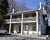
This is a list of the National Register of Historic Places listings in Pike County, Indiana.

<span class="mw-page-title-main">National Register of Historic Places listings in Lafayette County, Missouri</span>

This is a list of the National Register of Historic Places listings in Lafayette County, Missouri.

<span class="mw-page-title-main">National Register of Historic Places listings in Franklin County, Missouri</span>

This is a list of the National Register of Historic Places listings in Franklin County, Missouri.

<span class="mw-page-title-main">National Register of Historic Places listings in Pettis County, Missouri</span>

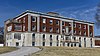
This is a list of the National Register of Historic Places listings in Pettis County, Missouri.

<span class="mw-page-title-main">National Register of Historic Places listings in Perry County, Missouri</span>

This is a list of the National Register of Historic Places listings in Perry County, Missouri.

<span class="mw-page-title-main">National Register of Historic Places listings in Iron County, Missouri</span>

This is a list of the National Register of Historic Places listings in Iron County, Missouri.

<span class="mw-page-title-main">National Register of Historic Places listings in Marion County, Missouri</span>

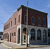
The following properties are listed on the National Register of Historic Places in Marion County, Missouri.

<span class="mw-page-title-main">National Register of Historic Places listings in Miller County, Missouri</span>

This is a list of the National Register of Historic Places listings in Miller County, Missouri.

<span class="mw-page-title-main">National Register of Historic Places listings in Clay County, Missouri</span>

This is a list of the National Register of Historic Places listings in Clay County, Missouri.

<span class="mw-page-title-main">National Register of Historic Places listings in Johnson County, Missouri</span>

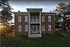
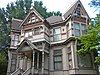
This is a list of the National Register of Historic Places listings in Johnson County, Missouri.

<span class="mw-page-title-main">National Register of Historic Places listings in Cole County, Missouri</span>

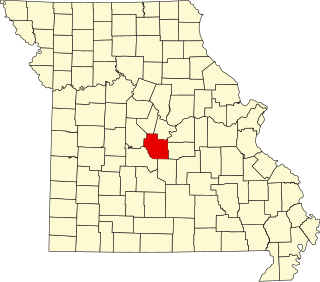
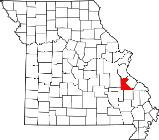
This is a list of the National Register of Historic Places listings in Cole County, Missouri.

<span class="mw-page-title-main">National Register of Historic Places listings in Carroll County, Missouri</span>

This is a list of the National Register of Historic Places listings in Carroll County, Missouri.

<span class="mw-page-title-main">National Register of Historic Places listings in Montgomery County, Missouri</span>

This is a list of the National Register of Historic Places listings in Montgomery County, Missouri.

<span class="mw-page-title-main">National Register of Historic Places listings in St. Francois County, Missouri</span>

This is a list of the National Register of Historic Places listings in St. Francois County, Missouri.

<span class="mw-page-title-main">National Register of Historic Places listings in Osage County, Missouri</span>

This is a list of the National Register of Historic Places listings in Osage County, Missouri.

<span class="mw-page-title-main">National Register of Historic Places listings in Henry County, Missouri</span>

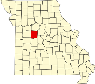
This is a list of the National Register of Historic Places listings in Henry County, Missouri.

<span class="mw-page-title-main">National Register of Historic Places listings in Dent County, Missouri</span>

This is a list of the National Register of Historic Places listings in Dent County, Missouri.

<span class="mw-page-title-main">National Register of Historic Places listings in Sullivan County, Missouri</span>

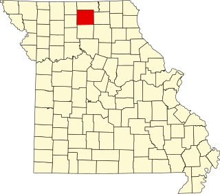
This is a list of the National Register of Historic Places listings in Sullivan County, Missouri.

<span class="mw-page-title-main">National Register of Historic Places listings in Linn County, Missouri</span>

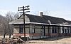
This is a list of the National Register of Historic Places listings in Linn County, Missouri.

<span class="mw-page-title-main">National Register of Historic Places listings in Lincoln County, Missouri</span>

This is a list of the National Register of Historic Places listings in Lincoln County, Missouri.

References

  1. The latitude and longitude information provided in this table was derived originally from the National Register Information System, which has been found to be fairly accurate for about 99% of listings. Some locations in this table may have been corrected to current GPS standards.
  2. National Park Service, United States Department of the Interior, "National Register of Historic Places: Weekly List Actions", retrieved May 10, 2024.
  3. Numbers represent an alphabetical ordering by significant words. Various colorings, defined here, differentiate National Historic Landmarks and historic districts from other NRHP buildings, structures, sites or objects.
  4. The eight-digit number below each date is the number assigned to each location in the National Register Information System database, which can be viewed by clicking the number.