
Santa Cruz is the county seat and largest city of Santa Cruz County, California. As of 2019, the U.S. Census Bureau estimated Santa Cruz's population at 64,608.

Alviso is a district of San Jose, California, located in North San Jose on the southern shores of San Francisco Bay. Originally an independent town, founded in 1852, today Alviso is San Jose's only waterfront district, primarily residential in nature, with several Silicon Valley tech companies and recreation-oriented businesses. Alviso is named after 19th-century Californio ranchero Ignacio Alviso, who owned the area as part of his Rancho Rincón de Los Esteros.

Point Reyes National Seashore is a 71,028-acre (287.44 km2) park preserve located on the Point Reyes Peninsula in Marin County, California. As a national seashore, it is maintained by the US National Park Service as an important nature preserve. Some existing agricultural uses are allowed to continue within the park. Clem Miller, a US Congressman from Marin County wrote and introduced the bill for the establishment of Point Reyes National Seashore in 1962 to protect the peninsula from development which was proposed at the time for the slopes above Drake's Bay. All of the park's beaches were listed as the cleanest in the state in 2010.
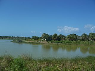
Pelican Island National Wildlife Refuge is a United States National Wildlife Refuge (NWR), and part of the Everglades Headwaters NWR complex, located just off the western coast of North Hutchinson Island in the Indian River Lagoon east of Sebastian, Florida. The refuge consists of a 3-acre (12,000 m2) island that includes an additional 2.5 acres (10,000 m2) of surrounding water and is located off the east coast of Florida of the Indian River Lagoon. Established by an executive order of President Theodore Roosevelt on March 14, 1903, Pelican Island was the first National wildlife refuge in the United States. It was created to protect egrets and other birds from extinction through plume hunting.
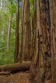
Big Basin Redwoods State Park is a state park in the U.S. state of California, located in Santa Cruz County, about 36 km (22 mi) northwest of Santa Cruz. The park contains almost all of the Waddell Creek watershed, which was formed by the seismic uplift of its rim, and the erosion of its center by the many streams in its bowl-shaped depression.

The Santa Cruz Beach Boardwalk is an oceanfront amusement park in Santa Cruz, California. Founded in 1907, it is California's oldest surviving amusement park and one of the few seaside parks on the West Coast of the United States.

Shoreline at Mountain View is a park in Mountain View, California, United States. The city park was dedicated in 1983, some fifteen years after the City undertook the daunting task of planning a regional park that would provide citizens with environmentally savvy recreation opportunities, from a site that was originally a landfill.

Assateague Island National Seashore is a unit of the National Park Service system of the U.S. Department of the Interior. Located on the East Coast along the Atlantic Ocean in Maryland and Virginia, Assateague Island is the largest natural barrier island ecosystem in the Middle Atlantic states region that remains predominantly unaffected by human development. Located within a three-hour drive to the east and south of Richmond, Washington, Baltimore, Wilmington, Philadelphia major metropolitan areas plus north of the several clustered smaller cities around Hampton Roads harbor of Virginia with Newport News, Hampton, Norfolk, Portsmouth, Chesapeake and Virginia Beach. The National Seashore offers a setting in which to experience a dynamic barrier island and to pursue a multitude of recreational opportunities. The stated mission of the park is to preserve and protect “unique coastal resources and the natural ecosystem conditions and processes upon which they depend, provide high-quality resource-based recreational opportunities compatible with resource protection and educate the public as to the values and significance of the area”.

Natural Bridges State Beach is a 65-acre (26 ha) California state park in Santa Cruz, California, in the United States. The park features a natural bridge across a section of the beach. It is also well known as a hotspot to see monarch butterfly migrations. The Monarch Butterfly Natural Preserve is home to up to 150,000 monarch butterflies from October through early February.
The California State Coastal Conservancy is a state agency in California established in 1976 to enhance coastal resources and public access to the coast. The CSCC is part of the California Natural Resources Agency.

Huntington State Beach is a protected beach in Southern California, located in the City of Huntington Beach in Orange County. It extends 2 miles (3.2 km) from Newport Beach north to Beach Boulevard, where the Huntington City Beach begins. The 121-acre (49 ha) park was established in 1942.

Perdido Key is an unincorporated community in Escambia County, Florida, United States, between Pensacola, Florida and Orange Beach, Alabama. "Perdido" means "lost" in the Spanish and Portuguese languages. The community is located on and named for Perdido Key, a barrier island in northwest Florida and southeast Alabama. The Florida district of the Gulf Islands National Seashore includes the east end of the island, as well as other Florida islands. No more than a few hundred yards wide in most places, Perdido Key stretches some 16 miles (26 km) from near Pensacola to Perdido Pass Bridge near Orange Beach.

Guadalupe-Nipomo Dunes is the largest remaining dune system south of San Francisco and the second largest in the U.S. state of California. It encompasses an 18-mile (29 km) stretch of coastline on the Central Coast of California and extends from southern San Luis Obispo County to northern Santa Barbara County.

The John Heinz National Wildlife Refuge at Tinicum is a 1000-acre (4.05 km2) National Wildlife Refuge in Philadelphia and Tinicum Township, Delaware County, in Pennsylvania. Adjacent to the Philadelphia International Airport, the refuge serves to protect the largest remaining freshwater tidal marsh in Pennsylvania. Established in 1972 as the Tinicum National Environmental Center, it was renamed in 1991 after the late H. John Heinz III who had helped preserve Tinicum Marsh.

Point Mugu State Park is a state park located in the Santa Monica Mountains National Recreation Area in Southern California. The rugged, nearly impassible shoreline of the western Santa Monica Mountains gives way to tidal lagoons and coastal sand dunes at Mugu Rock. The western edge of the park adjoins Mugu Lagoon which is a protected area within Naval Air Station Point Mugu.
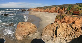
Pescadero State Beach is alongside State Route 1, located 14.5 miles south of Half Moon Bay and 1.5 miles west of the city of Pescadero in San Mateo County, California. The beach has a mile-long shoreline with sandy coves, rocky cliffs, tide pools, fishing spots and picnic facilities.

Rancho San Antonio County Park and Rancho San Antonio Open Space Preserve are a conjoined public recreational area in the Santa Cruz Mountains, in the northwest quadrant of Santa Clara County, California. The County Park is bordered by Los Altos with some parts of the eastern part of the County Park in western Cupertino. The Open Space Preserve is on the west side of the County Park, also bordered by Los Altos Hills, Monte Bello Open Space Preserve, and the Permanente Quarry.

Arana Gulch is a creek and landform that forms part of the southeastern boundary of the city of Santa Cruz, California. The creek begins in the Santa Cruz Mountains and flows southwest into Monterey Bay into what was once called Woods Lagoon, now the Santa Cruz Small Craft Harbor.

The Great Texas Coastal Birding Trail is a state-designated system of trails, bird sanctuaries, and nature preserves along the entire length of the Texas Gulf Coast in the United States. As the state of Texas hosts more bird species than any other state in the U.S. the trail system offers some of the most unusual opportunities for bird-watching in the world. The "trail" is actually 43 separate hiking and driving trails that include 308 birding sites. The sites themselves feature a variety of viewing opportunities with boardwalks, observation decks, and other amenities. The trails boast more than 450 bird species. The trail system is managed by the Texas Parks and Wildlife Department as part of the Great Texas Wildlife Trails which also include the Heart of Texas Wildlife Trail, the Panhandle Plains Wildlife Trail, and the Prairies and Pineywoods Wildlife Trail.

The Santa Cruz Small Craft Harbor is situated in Santa Cruz, California, on the site of the former Woods Lagoon. Built in 1962–1963, its public use specializes in boating and extracurricular marine activities for the local community and visitors. The harbor straddles the city limits which runs down the center of Arana Gulch; the west side of the harbor is in Santa Cruz's Seabright neighborhood while the east is in unincorporated Santa Cruz County.


