
Waterloo is a city in the Canadian province of Ontario. It is one of three cities in the Regional Municipality of Waterloo. Waterloo is situated about 94 km (58 mi) southwest of Toronto. Due to the close proximity of the city of Kitchener to Waterloo, the two together are often referred to as "Kitchener–Waterloo" or the "Twin Cities".

Kitchener is a city in the Canadian province of Ontario. It is one of three cities that make up the Regional Municipality of Waterloo, and is the regional seat. Kitchener is located about 100 km (62 mi) west of Toronto. Kitchener was previously known as Berlin until a 1916 referendum changed its name. The city covers an area of 136.86 km2, and had a population of 233,222 at the time of the 2016 census.

The Regional Municipality of Waterloo is a metropolitan area of Southern Ontario, Canada. It contains the cities of Cambridge, Kitchener and Waterloo, and the townships of North Dumfries, Wellesley, Wilmot and Woolwich. Kitchener, the largest city, is the seat of government.

The Township of Wilmot is a rural township in the Regional Municipality of Waterloo in southwestern Ontario, Canada.

The Township of Woolwich is a rural township in Southwestern Ontario, Canada, considered as a municipality. The Township is located in the northeast part of Waterloo Region and is made up of 10 small communities, with Elmira, Ontario the largest and St. Jacobs, Ontario the second largest. The population at the time of the 2016 Census was 25,006, up slightly from the 2011 population of 23,145. Waterloo Region is still home to the largest population of Old Order Mennonites in Canada, particularly in the areas around St Jacobs and Elmira. They are often seen on the local roads using their traditional horse and buggy transportation; many also use horses to pull the implements in their farm fields.
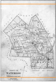
Waterloo County, created in 1853 and dissolved in 1973, was the forerunner of the Regional Municipality of Waterloo in Ontario, Canada. Situated on a subset of land within the Haldimand Tract, the traditional territory of the Attawandaron, Anishinaabe and Haudenosaunee peoples, Waterloo County consisted of five townships: Woolwich, Wellesley, Wilmot, Waterloo, and North Dumfries. The major population centres were Waterloo, Kitchener, Preston, Hespeler, Blair, and Doon in Waterloo township; Galt in North Dumfries; Elmira in Woolwich; and New Hamburg in Wilmot. All are now part of the Regional Municipality.

The Township of Wellesley is the rural, north-western township of the Regional Municipality of Waterloo in Ontario, Canada. It encompasses 277.79 km2 (107.26 sq mi) and had a population of 11,260 in the Canada 2016 Census.

Mount Forest is an unincorporated community located at the junction of Highway 6 and Highway 89 in the township of Wellington North, Ontario, Canada. As of the 2011 Canadian census the population of Mount Forest was 4,757.

West Montrose is an unincorporated rural community in Woolwich Township in the Regional Municipality of Waterloo, Ontario, Canada. As of the 2016 census, the population of the community was 257.
German Canadians are Canadian citizens of German ancestry or Germans who emigrated to and reside in Canada. According to the 2016 census, there are 3,322,405 Canadians with full or partial German ancestry. Some immigrants came from what is today Germany, while larger numbers came from German settlements in Eastern Europe and Imperial Russia; others came from parts of the German Confederation, Austria-Hungary and Switzerland.

Baden is a suburban community and unincorporated place in Township of Wilmot, Regional Municipality of Waterloo in Southwestern Ontario, Canada. It has a population around 4,500 and was named after Baden-Baden, Germany. The approximate population as of 2015, as per township statistics, is 4,940.
New Hamburg is a community of approximately 11,953 in the township of Wilmot, Ontario, Canada. It is in the far western part of the Region of Waterloo, near the regional border with Perth County. It is adjacent to the community of Baden, which sits to its east and is also a part of the township of Wilmot. The nearest cities are Kitchener, Waterloo, and Stratford.

Waterloo is the name of a federal electoral district in the Waterloo Region of Ontario, Canada, that has been used in the House of Commons of Canada from since 1968. Between 1997 and 2015, the riding was known as Kitchener—Waterloo.

Preston is a community in Cambridge, Ontario, Canada in the Regional Municipality of Waterloo, Ontario. Prior to 1973 it was an independent town, incorporated in 1915, but amalgamation with the town of Hespeler, Ontario, the city of Galt, Ontario and the village of Blair formed the new municipality of Cambridge. Parts of the surrounding townships were also included. No population data is available for the former Preston since the Census reports cover only the full area of Cambridge, though the combined population of the census tracts covering the majority of Preston reported a population of 20,008 as of the 2016 Canada Census. The first mayor of Cambridge was Claudette Millar.
New Dundee is a small community of 1,119 people at the time of the 2016 Census, in the township of Wilmot, Ontario, Canada. It is located southwest of Kitchener.
Waterloo Region District School Board is the public school board for the Region of Waterloo in Ontario, Canada. It operates 105 elementary schools, 16 secondary schools, and other facilities, serving more than 64,000 students in the Region of Waterloo. It has approximately 6,800 staff and a budget of $675 million. It is the largest public sector employer in the Region and the second largest employer overall. In early 2018, the director of education is John Bryant.

Maryhill is an unincorporated rural community in the township of Woolwich, Waterloo Region, Ontario, Canada. The population was 576 in 2016.
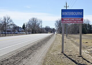
Winterbourne is a village located to the east of the Grand River in the township of Woolwich, Ontario in the Regional Municipality of Waterloo. It is located just northeast of the city of Waterloo. The fine stonework of the Scottish stonemasons can be seen in many of the older buildings throughout the settlement.

Floradale is an unincorporated rural community in Southwestern Ontario, Canada. It is part of the township of Woolwich in the Regional Municipality of Waterloo. The community is located 5 kilometres to the north of the town of Elmira, Ontario and 20 kilometres to the north of the city of Waterloo, Ontario. The Canagagigue Creek, a tributary of the Grand River, flows through the village. The community is located in an area where there is an historically large settlement of Old Order Mennonites noted for their traditional customs, dress, and use of horse and buggies.

Maple Hill is an dispersed rural community in the township municipality of Brockton, Bruce County, Ontario, Canada.


