The Regional Municipality of Waterloo is a metropolitan area of Southern Ontario, Canada. It contains the cities of Cambridge, Kitchener and Waterloo, and the townships of North Dumfries, Wellesley, Wilmot and Woolwich. Kitchener, the largest city, is the seat of government.

Elmira is the largest community in the township of Woolwich, Ontario, Canada. It is 15 kilometres (9 mi) north of the city of Waterloo near the Regional Municipality of Waterloo's northern border with Wellington County. The community was listed in the 2016 Canadian census as having a population of 10,161.

The Township of Woolwich is a rural township in Southwestern Ontario, Canada, considered as a municipality. The Township is located in the northeast part of Waterloo Region and is made up of 10 small communities, with Elmira, Ontario the largest and St. Jacobs, Ontario the second largest. The population at the time of the 2021 Census was 26,999, up from the 2016 population of 25,006. Waterloo Region is still home to the largest population of Old Order Mennonites in Canada, particularly in the areas around St Jacobs and Elmira. They are often seen on the local roads using their traditional horse and buggy transportation; many also use horses to pull the implements in their farm fields.

Waterloo County was a county in the Canadian province of Ontario from 1853 until 1973. It was the direct predecessor of the Regional Municipality of Waterloo.

West Montrose is an unincorporated rural community in Woolwich Township in the Regional Municipality of Waterloo, Ontario, Canada. As of the 2016 census, the population of the community was 257.

St. Jacobs is a community and former village located in the township of Woolwich in Waterloo Region, Ontario, just north of the city of Waterloo. It is a popular location for tourism, due to its quaint village appearance, retail focus and Mennonite heritage. Waterloo Region is still home to the largest population of Old Order Mennonites in Canada, particularly in the areas around St Jacobs and Elmira. They are often seen on the local roads using their traditional horse and buggy transportation; many also use horses to pull the implements in their farm fields.
Zuber Corners is an unincorporated rural community in Woolwich Township, Waterloo, Ontario, Canada.
Waterloo North was a federal electoral district represented in the House of Commons of Canada from 1867 to 1968. It was located in the province of Ontario. It was created by the British North America Act of 1867 which entitled each of north and south ridings of the County of Waterloo to elect one Member of Parliament.
Waterloo is the name of a federal electoral district in the Waterloo Region of Ontario, Canada, that has been used in the House of Commons of Canada from since 1968. Between 1997 and 2015, the riding was known as Kitchener—Waterloo.
The Waterloo Regional Police Service (WRPS) provides policing services for the Regional Municipality of Waterloo in Ontario, Canada, which encompasses the cities of Waterloo, Kitchener, and Cambridge, as well as the townships of North Dumfries, Wellesley, Wilmot and Woolwich. The WRPS was established in 1973, to replace the individual police departments in the region. The cities of Kitchener, Waterloo and Galt; the towns of Preston, Hespeler, Elmira and New Hamburg; the Village of Bridgeport and Waterloo Township had their own respective police department. The townships of Woolwich, Wellesley, Wilmot and North Dumfries were under the jurisdiction of the Ontario Provincial Police. In 1991 the Waterloo Regional Police Force was renamed to their current name.
Waterloo Region District School Board is the public school board for the Region of Waterloo in Ontario, Canada. It operates 105 elementary schools, 16 secondary schools, and other facilities, serving more than 64,000 students in the Region of Waterloo. It has approximately 6,800 staff and a budget of $675 million. It is the largest public sector employer in the Region and the second-largest employer overall. In early 2018, the director of education is John Bryant.

Maryhill is an unincorporated rural community in the township of Woolwich, Waterloo Region, Ontario, Canada. The population was 576 in 2016.

Isaac Erb Bowman was an Ontario businessman and political figure. He represented Waterloo North in the House of Commons of Canada as a Liberal member from 1867 to 1878 and from 1887 to 1896.
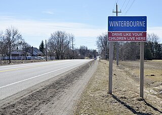
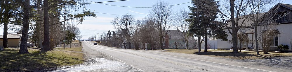
Winterbourne is a village located to the east of the Grand River in the township of Woolwich in the Regional Municipality of Waterloo, Ontario, Canada. It is located just northeast of the city of Waterloo. The fine stonework of the Scottish stonemasons can be seen in many of the older buildings throughout the settlement.
Region of Waterloo Paramedic Services (ROWPS) is the emergency medical service provider for the Regional Municipality of Waterloo. The service provides both advanced and primary care level paramedic services to the cities of Waterloo, Ontario, Cambridge, Ontario and Kitchener, Ontario and the townships of Wilmot, Woolwich, Wellesley and North Dumfries.

Conestogo is a community in the Canadian province of Ontario, located in the township of Woolwich in Waterloo Region. The population in 2016 was 1,270.

Floradale is an unincorporated rural community in Southwestern Ontario, Canada. It is part of the township of Woolwich in the Regional Municipality of Waterloo. The community is located 5 kilometres to the north of the town of Elmira, Ontario and 20 kilometres to the north of the city of Waterloo, Ontario. Canagagigue Creek, a tributary of the Grand River, flows through the village. The community is located in an area where there is an historically large settlement of Old Order Mennonites noted for their traditional customs, dress, and use of horse and buggies.

Weissenburg is an unincorporated rural community in Woolwich Township, Waterloo, Ontario, Canada.
The 2014 Waterloo Region municipal elections were held on October 27, 2014 in the Regional Municipality of Waterloo, Ontario, Canada, to elect Waterloo Regional Council, the mayors and city councils of Cambridge, Kitchener, North Dumfries, Waterloo, Wellesley, Wilmot, and Woolwich, the Waterloo Region District School Board (Public), the Waterloo Catholic District School Board, and the regional members of Conseil Scolaire de District Catholiques Centre-Sud and Conseil Scolaire Viamonde (Public). The election was held in conjunction with the provincewide 2014 municipal elections.
The 2022 Waterloo Region municipal elections were held on October 24, 2022, in the Regional Municipality of Waterloo, Ontario, Canada, to elect Waterloo Regional Council, the mayors and city councils of Cambridge, Kitchener, North Dumfries, Waterloo, Wellesley, Wilmot, and Woolwich, the Waterloo Region District School Board (Public), the Waterloo Catholic District School Board, and the regional members of Conseil Scolaire de District Catholiques Centre-Sud and Conseil Scolaire Viamonde (Public). The election will be held in conjunction with the province wide 2022 municipal elections.