Woolwich, Ontario

Last updated
Woolwich
Township of Woolwich
Aerial Woolwich.jpg
Waterloo locator map 2021.svg
Red pog.svg
Woolwich
Canada Southern Ontario location map 2.png
Red pog.svg
Woolwich
Coordinates: 43°34′N80°29′W / 43.567°N 80.483°W / 43.567; -80.483
Country Flag of Canada (Pantone).svg  Canada
Province Flag of Ontario.svg  Ontario
Regional municipality Waterloo
Settled1798
Incorporated1816
Government
  TypeTownship
  MayorSandy Shantz [1]
  Councillors
List
  Governing BodyWoolwich Township Council
   MP Tim Louis (LPC)
   MPP Mike Harris Jr. (PC)
Area
[2]
  Land326.15 km2 (125.93 sq mi)
Population
 (2021) [3]
  Total26,999
  Density82.8/km2 (214/sq mi)
Time zone UTC-5 (EST)
  Summer (DST) UTC-4 (EDT)
Area code(s) 519, 226, 548
Website www.woolwich.ca

The Township of Woolwich is a rural township in Southwestern Ontario, Canada, considered as a municipality. The Township is located in the northeast part of Waterloo Region and is made up of 10 small communities, with Elmira, Ontario the largest and St. Jacobs, Ontario the second largest. The population at the time of the 2021 Census was 26,999, up from the 2016 population of 25,006. Waterloo Region is still home to the largest population of Old Order Mennonites in Canada, particularly in the areas around St Jacobs and Elmira. [4] They are often seen on the local roads using their traditional horse and buggy transportation; many also use horses to pull the implements in their farm fields. [4] [5] [6] [7] [8]

Contents

Woolwich is part of the Regional Municipality of Waterloo and is located directly to the north and east of the City of Waterloo. It is bounded by the cities of Kitchener, Waterloo, and Cambridge. The township is a municipality as established by the Regional Municipality of Waterloo Act 1972, which created a regional government structure and established limits of the local municipalities effective January 1, 1973. Woolwich Township has its own municipal government consisting of five Councillors and a Mayor; the latter also serves on the Waterloo Region Council. [9]

History

Early history

The land which now makes up Woolwich Township, with the Grand River on the East, and the Conestogo River on the West, originally belonged to the Huron Nation followed by the Mohawk Nation. The first settlers arrived in the late 18th century. In 1798, William Wallace was one of the first settlers after he was deeded 86,078 acres (348 km2) of land on the Grand River for a cost of $16,364. Originally Block three of Indian Lands, this area now comprises a large part of Woolwich Township. The parcel of land called "Woolwich" was probably named (in 1816) after a town in Kent, England. The early settlers were primarily from England or Ireland until about 1830; they settled to the east of the Grand River. Afterwards, German Mennonite families from Pennsylvania and from Waterloo Township settled west of the river. [10]

In 1807, Wallace sold the major portion of his tract to Mennonites from Pennsylvania, trustees for the German Company, many of whom would settle this area. [11] Wallace sold 45,185 acres (183 km2) of land to the German Company at $1.00 an acre. Captain Smith, a loyalist from Vermont, settled at the confluence of the Grand and Conestogo Rivers in 1807. Their large log home served as an inn for travelers and he operated a stagecoach for carrying mail from 1835 to 1850. The first church in Woolwich, was built by the Mennonites from Pennsylvania in approximately 1823 at the Three Bridges, now part of Conestogo. [12] Woolwich was incorporated as a Township in 1816, and was part of Halton County until 1842 when it became part of Wellington District. In 1852, it became part of the new Waterloo County. [13]

Starting in 1821, a part of Woolwich, to the east of the Grand River (Block 3), owned by James Crooks, attracted dozens of families from England and Scotland. Previously, this area had few settlers, the most notable a Mr. Cox; the creek which enters the Grand River at what is now Winterbourne was named after him. Immigrants from Scotland began settling the Cox Creek area in 1834, led by John Davidson. He opened the first post office in the township, naming it East Woolwich. Captain Henry Lanphier arrived in 1854 and soon built a sawmill and flour mill after damming Cox Creek. Residents agreed with him that the settlement should be renamed Winterbourne, Ontario. By 1837, the Scots established St. Andrew's Presbyterian in 1837. A Presbyterian church was not built until 1870, made of logs; it was replaced in 1870 by one built of brick, and is currently a private home near the Winterbourne Presbyterian Cemetery. By 1867, Winterbourne had a population of 160, three churches, a school, a post office, a general store, two mills, two hotels, two blacksmiths, a tailor, shoemaker and a physician. [14]

St. Jacobs, like nearby Conestogo (both in Woolwich), was primarily Germanic and was first settled in 1830. [15] In 1834, Edward Bristow from Sussex, England [16] became one of Elmira's first settlers when he purchased 53 acres (210,000 m2) of land at this location for 50 cents per acre. He started the first store, tavern and potashery. [17] A community by the name of Bristow's Corners was already in existence in 1839 when a post office was assigned there; it was renamed Elmira in 1853.

Old Order Mennonite buggy still common in Woolwich Township Mennonite carriage (cropped).jpg
Old Order Mennonite buggy still common in Woolwich Township

Historical records suggest that David Musselman founded Conestogo after buying land in 1830. He built a sawmill in 1844 and after damming the Conestogo River, he added a flour mill and a second sawmill. The hamlet formed in this area, known as Musselman's Mills until 1852 when it became Conestogo because many of the settlers had come from the Conestoga River area of Pennsylvania. [12] Records about the entire township from 1846 indicate that the area was thinly settled although the land was excellent and there were large tracts of hardwood. There were two grist and two saw mills and an Episcopal church. The population count in 1841 indicated 1009 people. [18]

Woolwich Township Council was organized in January 1850 with five councillors, of whom John N. Meyer was named as Reeve; James Dow was appointed as clerk and treasurer. [19] A significant influx to the St. Jacobs area started afterwards, primarily consisting of additional Mennonites from Pennsylvania. Farmer and pioneer industrialist Jacob C. Snider, of Swiss German descent, was the most important settler at the time and the community was named after him: Jakobstettel (Jacob's Village). He built a dam to power several mills and then built a sawmill, woolen mill and flour mill by 1852. This helped to attract others to the small community. [20] [21] The St. was added to the name simply to make it sound more pleasing and the pluralization was in honour of the combined efforts of Jacob C. Snider (1791–1865) and his son, Jacob C. Snider Jr. (1822–1857), founders of the village. [22] The first post office in St. Jacobs opened in 1852, called St. Jacobs and the village was incorporated in that year. By 1855, the population was 400. [15] Mennonites formed a significant proportion of the population in the 1850s. Most were the so-called Pennsylvania Dutch, not referring to the Netherlands but a misnomer for Deitsch or Deutsch (German). They became known as Old Order Mennonite due to their very conservative, traditional lifestyle. (Other Mennonites in the area now have a less conservative lifestyle.) [23] [24] [25] [26]

Decentralization and later urban growth

Throughout its early history, Woolwich was predominantly decentralized and rural in character. It did not become the location of the Waterloo County administration apparatus, and the first wave of railway development in the county passed it by. In his study of Waterloo County's growth and urbanization, urban studies scholar Fred Dahms uses "functional units" as a metric of a settlement's developmental complexity, rather than relying on population counts, village or town status, or other metrics. Each "functional unit" is based on a defined economic hub or activity, such as banking or postal services, milling, or a general store. In this measure, one building (such as a combined general store and post office) would count as multiple functional units, providing an alternative way to measure the development of a pioneer economy. [27] For 1864, while Woolwich had no large centre falling within the top five counts of functional units, it did have three in the top ten: St. Jacobs, Elmira, and Conestogo. [28] St. Jacobs, Conestogo, Winterbourne, and Elmira were all incorporated as villages by this point. [11]

St. James Lutheran Church, Elmira. Church Elmira.jpg
St. James Lutheran Church, Elmira.

By the 1870s, things had changed dramatically; economic activity in Waterloo County was rapidly centralizing, and Elmira was now tied for fifth in the county in terms of functional units, alongside Ayr. [28] In 1878, a significant majority of Woolwich village industries advertising themselves in the Armstrong and Company Gazetteer and Directory for Waterloo County were located in Elmira, with a number also located in St. Jacobs. This included carriage makers, lumber mills, metal crafters, a saddle and harness maker, a woollen mill, and others. [29] In 1891, the Waterloo Junction Railway (part of the Grand Trunk Railway system) was extended north from Waterloo through Heidelberg and St. Jacobs, to Elmira. [30] The Guelph and Goderich Railway (part of the Canadian Pacific Railway system) would later follow, running across the township from east to west.

In the early 1900s, Woolwich Township exhibited a strong German culture and those of German origin made up a third of the population in 1911. Because of increased immigration direct from Germany, Lutherans were the primary religious group by that time; there were nearly three times as many Lutherans as Mennonites. [31]

Woolwich was the location of one of the earliest concrete roads in Canadian history. A 1.5-mile (2.4 km) stretch of what was then Provincial County Road 75, between St. Jacobs and the Grand Trunk Railway crossing south of Elmira, was upgraded in 1919 using a provincial subsidy under the newly-created Department of Public Highways of Ontario. [32]

During the 1960s, due to the poor disposal practices of chemical manufacturers, contamination seeped down to the aquifer in and around Elmira. This contamination forced local water wells to close in 1990. Water is now delivered via a pipeline from Waterloo and other near local areas. [33] [34] [35]

Demographics

Historical population
YearPop.±%
199117,365    
1996 17,325−0.2%
2001 18,201+5.1%
2006 19,658+8.0%
2011 23,145+17.7%
2016 25,006+8.0%
2021 26,999+8.0%

In the 2021 Census of Population conducted by Statistics Canada, Woolwich had a population of 26,999 living in 9,359 of its 9,556 total private dwellings, a change of

In 2016, the average age in Woolwich was 39, with 49% of the population male and 51% female. [36] In 2016, English was the predominant language spoken at 88% of households, followed by German 8%, and Dutch 0.58%, which make up the top three most spoken languages in Woolwich. [37]

Economy

The St. Jacobs Market is a major tourist attraction St Jacobs Market.jpg
The St. Jacobs Market is a major tourist attraction

Elmira is the primary industrial centre of Woolwhich Township. Major employers include Trylon TSF, [38] Sanyo Machine Works, Elmira Pet Products, Lanxess (formerly Chemtura and Uniroyal), Toyota Boshoku (formerly Trim Masters), Engineered Lifting Systems, and Southfield Windows & Doors. Since the 1970s, tourism has become an increasingly important industry in Elmira and especially in St. Jacobs which has a very popular Farmers' Market and many quaint stores in its downtown area. [39] [40] [41]

St. Jacobs features dozens of artisans in historic buildings, such as the Country Mill, Village Silos, Mill Shed, and the Old Factory. Visitors may watch artisans make pottery, quilts, designer clothes, jewellery, glass vases, woven wall hangings tiffany lamps, stained glass doors, miniature doll houses and more. There are also two blacksmith shops. The two-kilometre millrace is a pleasant, treed hiking path along the Conestogo River. The Visitor Centre in downtown St. Jacobs is a Mennonite interpretation centre, providing information and education about the Mennonite people in the township. [42]

The original Home Hardware building Home Hardware building St Jacobs Ontario.jpg
The original Home Hardware building

St. Jacobs is also the headquarters of Home Hardware, a national chain of over 1000 independent hardware retail stores located across Canada that was founded in the village in 1963. The first store opened in St. Jacobs in 1964. It remains in use by the chain as the furniture outlet but a new store was built across the street, opening in November 2014. [43]

Economic development for the township is handled by the Region of Waterloo. Elmira and St. Jacobs have their own Business Improvement Area committees. [44] [45]

Government

The township is governed by an elected Mayor and five elected Councillors; two Councillors representing Wards 1 and 3, and one for Ward 2. [1] Council meetings are held in the Council Chambers at 24 Church Street West, Elmira. [46] The Mayor serves also as the Regional Councillor and sits on the various boards, including Waterloo North Hydro, Grand River Conservation Authority, Regional Library Board, Kiwanis Transit Board, Waterloo Region Community Housing Committee, Kissing Bridge Trailway Advisory Committee and Airport Master Plan Committee. [47] After the election in 2018 the elected council members are: [1]

Mayor: Sandy Shantz

Councillors:

Woolwich is one of seven municipalities that make up the Waterloo Regional Council. Members of the Regional Council serve a four-year term and Woolwich's representative is the Mayor alone. [48] The Waterloo Regional Council is made up of the Chair and eight Councillors, as well as the mayors of the seven municipalities: Cambridge, Kitchener, Waterloo, and the Townships of North Dumfries, Wellesley, Wilmot and Woolwich. [48]

Communities

Street scene in Elmira Elmira Street.jpg
Street scene in Elmira

Woolwich consists of an extensive rural area along with residential communities and industrial/commercial areas. The residential communities include: Elmira, St. Jacobs, Breslau, Conestogo, Heidelberg, Maryhill, North Woolwich, Bloomingdale, Weissenburg, West Montrose, Floradale, Winterbourne, and Zuber Corners.

The three largest areas offering a range of residential, industrial, commercial and recreational uses are in Elmira, St. Jacobs and Breslau; the latter adjoins Kitchener and is the fastest growing community in the township.

Woolwich Township spans approximately 326.15 km². [37]

Infrastructure

Health and medicine

Woolwich does not have its own hospitals, but residents of Woolwich have access to four nearby hospitals: Grand River Hospital, St. Mary's General Hospital, Groves Memorial Community Hospital in Fergus [49] and Guelph General Hospital. [50]

Transportation

Woolwich is home to the Region of Waterloo International Airport (YKF), which is south of Breslau to the east of the Grand River.

There are two railway lines through Woolwich: the Guelph Subdivision (running approximately east–west) and the Waterloo Spur, a branch line of the Guelph Subdivision which runs north through Waterloo and St. Jacobs before terminating at Elmira. The junction of the two lines is in Kitchener, east of the Kitchener railway station. The Canadian National Railway (CN) operates freight rail services on both lines. The Waterloo Central Railway, a tourist and heritage railway, operates along the Waterloo Spur between Elmira and a stop near Northfield station in north Waterloo. It provides the only stopping passenger service in Woolwich. GO Transit and Via Rail operate regional and intercity services respectively, both along the Guelph Subdivision, but do not stop in the township. A GO station in Breslau is planned, [51] which would provide GO Transit passenger service on the Kitchener line.

Grand River Transit's 21 Elmira route provides local bus service between Woolwich and Waterloo, running between Conestoga station (in Waterloo) and Elmira. The route launched in 2009. [52] PC Connect, an inter-regional community bus service based in Perth County, launched in 2020 with a route connecting Kitchener, Waterloo, St. Jacobs, Elmira, and Listowel together. [53]

Highways

Trails

Woolwich Township has eleven trails; much of the 45-kilometre (28 mi) long Kissing Bridge Trailway runs through this area. [54]

Woolwich Memorial Centre

The Woolwich Memorial Centre (WMC) is the Township of Woolwich's newest state-of-the-art facility comprising two NHL-sized ice surfaces, two pools, a fitness centre and walking track. The facility also includes a community centre, seniors centre, youth centre, Concourse Cafe, two meeting rooms and offices for minor sport teams. [55]

Education

Schools in Woolwich are operated by the Waterloo Region District School Board and Waterloo Catholic District School Board. [56] Woolwich has eight elementary schools, seven of which are public and one is Catholic. [56] [37] Elmira District Secondary School is Woolwich's only secondary (high) school, but is ranked by Fraser Institute as a top Ontario high school. [37] [57]

See also

Related Research Articles

<span class="mw-page-title-main">Waterloo, Ontario</span> City in Ontario, Canada

Waterloo is a city in the Canadian province of Ontario. It is one of three cities in the Regional Municipality of Waterloo. Waterloo is situated about 94 km (58 mi) west-southwest of Toronto, but it is not considered to be part of the Greater Toronto Area (GTA). Due to the close proximity of the city of Kitchener to Waterloo, the two together are often referred to as "Kitchener–Waterloo", "K-W", or "The Twin Cities".

<span class="mw-page-title-main">Kitchener, Ontario</span> City in Ontario, Canada

Kitchener is a city in the Canadian province of Ontario, about 100 km (62 mi) west of Toronto. It is one of three cities that make up the Regional Municipality of Waterloo and is the regional seat. Kitchener was known as Berlin until a 1916 referendum changed its name. The city covers an area of 136.86 km2, and had a population of 256,885 at the time of the 2021 Canadian census.

<span class="mw-page-title-main">Cambridge, Ontario</span> City in Ontario, Canada

Cambridge is a city in the Regional Municipality of Waterloo, Ontario, Canada, located at the confluence of the Grand and Speed rivers. The city had a population of 138,479 as of the 2021 census. Along with Kitchener and Waterloo, Cambridge is one of the three core cities of Canada's tenth-largest metropolitan area.

<span class="mw-page-title-main">Regional Municipality of Waterloo</span> Upper-tier regional municipality in Ontario, Canada

The Regional Municipality of Waterloo is a metropolitan area of Southern Ontario, Canada. It contains the cities of Cambridge, Kitchener and Waterloo, and the townships of North Dumfries, Wellesley, Wilmot and Woolwich. Kitchener, the largest city, is the seat of government.

<span class="mw-page-title-main">Elmira, Ontario</span> Unincorporated community in Ontario, Canada

Elmira is the largest community in the township of Woolwich, Ontario, Canada. It is 15 kilometres (9 mi) north of the city of Waterloo near the Regional Municipality of Waterloo's northern border with Wellington County. The community was listed in the 2016 Canadian census as having a population of 10,161.

<span class="mw-page-title-main">Wilmot, Ontario</span> Township in Ontario, Canada

The Township of Wilmot is a rural township in the Regional Municipality of Waterloo in southwestern Ontario, Canada.

<span class="mw-page-title-main">Waterloo County, Ontario</span> Former county in Ontario, Canada

Waterloo County was a county in Canada West in the United Province of Canada from 1853 until 1867, then in the Canadian province of Ontario from 1867 until 1973. It was the direct predecessor of the Regional Municipality of Waterloo.

<span class="mw-page-title-main">Wellesley, Ontario</span> Township in Ontario, Canada

The Township of Wellesley is the rural, north-western township of the Regional Municipality of Waterloo in Ontario, Canada. It encompasses 277.79 km2 (107.26 sq mi) and had a population of 11,260 in the Canada 2016 Census.

<span class="mw-page-title-main">West Montrose, Ontario</span> Unincorporated rural community in Ontario, Canada

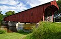
West Montrose is an unincorporated rural community in Woolwich Township in the Regional Municipality of Waterloo, Ontario, Canada. As of the 2016 census, the population of the community was 257.

<span class="mw-page-title-main">St. Jacobs, Ontario</span> Unincorporated community in Ontario, Canada

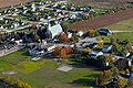
St. Jacobs is an unincorporated suburban community in the township of Woolwich in Waterloo Regional Municipality, Ontario, Canada. It is located north of the city of Waterloo. It is a popular location for tourism, due to its quaint appearance, retail focus and Mennonite heritage. Waterloo Region is still home to the largest population of Old Order Mennonites in Canada, particularly in the areas around St Jacobs and Elmira. They are often seen on the local roads using their traditional horse and buggy transportation; many also use horses to pull the implements in their farm fields.

<span class="mw-page-title-main">Baden, Ontario</span> Suburban Community in Waterloo, Ontario, Canada

Baden is a suburban community and unincorporated place in Township of Wilmot, Regional Municipality of Waterloo in Southwestern Ontario, Canada. It was named after Baden-Baden, Germany; the approximate population as of 2015, as per township statistics, is 4,940.

<span class="mw-page-title-main">New Hamburg, Ontario</span> Unincorporated community in Ontario, Canada

New Hamburg is a community of approximately 11,953 in the township of Wilmot, Ontario, Canada. It is in the far western part of the Regional Municipality of Waterloo, near the regional border with Perth County. It is adjacent to the community of Baden, which sits to its east and is also a part of the township of Wilmot. The nearest cities are Kitchener, Waterloo, and Stratford.

<span class="mw-page-title-main">Hawkesville, Ontario</span> Unincorporated community in Ontario, Canada

The village of Hawkesville in Ontario, Canada is a small community in the township of Wellesley in the Regional Municipality of Waterloo. Several Mennonite families are located nearby. Hawkesville is noted for its custom-built furniture industry.

Waterloo Region District School Board is the public school board for the Region of Waterloo in Ontario, Canada. It operates 105 elementary schools, 16 secondary schools, and other facilities, serving more than 64,000 students in the Region of Waterloo. It has approximately 6,800 staff and a budget of $675 million. It is the largest public sector employer in the Region and the second-largest employer overall. In early 2018, the director of education is John Bryant.

<span class="mw-page-title-main">Winterbourne, Ontario</span> Unincorporated community in Ontario, Canada

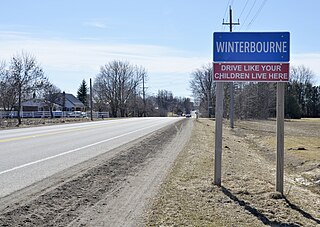
Winterbourne is a village located to the east of the Grand River in the township of Woolwich in the Regional Municipality of Waterloo, Ontario, Canada. It is located just northeast of the city of Waterloo. The fine stonework of the Scottish stonemasons can be seen in many of the older buildings throughout the settlement.

<span class="mw-page-title-main">Breslau, Ontario</span> Unincorporated community in Ontario, Canada

Breslau (bɹˈɛsla͡ʊ) is a community located within the township of Woolwich, part of the Waterloo Regional Municipality in Ontario Canada. Separated from the city of Kitchener by the Grand River, Breslau is named after the former German city of Breslau, now Wrocław, capital of Poland's Lower Silesia.

<span class="mw-page-title-main">Conestogo, Ontario</span> Unincorporated community in Ontario, Canada

Conestogo is a community in the Canadian province of Ontario, located in the township of Woolwich in Waterloo Region. The population in 2016 was 1,270.

<span class="mw-page-title-main">Floradale, Ontario</span> Unincorporated community in Ontario, Canada

Floradale is an unincorporated rural community in Southwestern Ontario, Canada. It is part of the township of Woolwich in the Regional Municipality of Waterloo. The community is located 5 kilometres to the north of the town of Elmira, Ontario and 20 kilometres to the north of the city of Waterloo, Ontario. Canagagigue Creek, a tributary of the Grand River, flows through the village. The community is located in an area where there is an historically large settlement of Old Order Mennonites noted for their traditional customs, dress, and use of horse and buggies.

<span class="mw-page-title-main">Hespeler, Ontario</span> Place in Ontario, Canada

Hespeler is a neighbourhood and former town within Cambridge, Ontario, located along the Speed River in the Regional Municipality of Waterloo, Ontario, Canada. In 1973, Hespeler, Preston, Galt, and the hamlet of Blair were amalgamated to form the City of Cambridge. The first mayor of Cambridge was Claudette Millar.

<span class="mw-page-title-main">Waterloo Junction Railway</span>

The Waterloo Junction Railway (WJR) is a short line railway in the Region of Waterloo, Ontario, Canada. It runs northward from the former Grand Trunk Railway (GTR) North Main Line in downtown Kitchener, through Waterloo and St. Jacobs before terminating in Elmira. It is currently owned by the City of Waterloo and operated by CN as the Waterloo Spur. The Waterloo Central Railway runs tourist trains on the line, and the Ion rapid transit runs on the route for a short distance.

References

Citations

  1. 1 2 3 "Woolwich Township Official Election Results" (PDF). Woolwich Township. Retrieved 2018-12-14.
  2. "Woolwich, Ontario (Code 3530035) census profile". 2011 Census of Population . Statistics Canada. Retrieved 2012-08-17.
  3. 1 2 "Population and dwelling counts: Canada, provinces and territories, census divisions and census subdivisions (municipalities), Ontario". Statistics Canada. February 9, 2022. Retrieved April 2, 2022.
  4. 1 2 "Old Order Mennonites". Canada Alive!. March 31, 2014. Retrieved May 22, 2019.
  5. "Old Order Mennonites". Global Anabaptist Mennonite Encyclopedia Online (GAMEO). Retrieved May 22, 2019.
  6. "Tours and Self-Guided Tours". Woolwich Township. Retrieved May 22, 2019.
  7. Draper, Barb (December 1, 2015). "Old Order Mennonite groups in Ontario are growing". Canadian Mennonite Magazine. Retrieved May 22, 2019.
  8. "About Woolwich". Woolwich Township. 20 March 2018. Retrieved May 22, 2019.
  9. "Mayor and Council". Woolwich Township. Retrieved May 22, 2019.
  10. "Woolwich Township". Ken Seiling Waterloo Region Museum. Retrieved May 22, 2019. (section "History of Woolwich Township")
  11. 1 2 Sutherland 1864, p. 61.
  12. 1 2 Uttley 1935, p. 16.
  13. Uttley 1935, p. 12–14.
  14. Mills, Rych (October 13, 2017). "Flash from the Past: A Scottish enclave in Woolwich Township". Waterloo Region Record. Metroland News. Retrieved May 22, 2019.
  15. 1 2 "Woolwich Township". Ken Seiling Waterloo Region Museum. Retrieved May 22, 2019. (section "St. Jacobs")
  16. "Hannah Streater". Lloyd McBurney. Retrieved May 22, 2019.
  17. "Elmira Travel Guide". Worldweb.com. Retrieved May 23, 2019.
  18. Smith 1846, pp.  223–224.
  19. Uttley 1935, p. 14.
  20. "The Village of St. Jacobs: A Glimpse into Ontario's Mennonite Heritage". Magic Carpet Journal.
  21. "St. Jacobs Self Guided Historic Walking Tour" (PDF). Retrieved May 23, 2019.
  22. Exploring Ontario: St. Jacobs
  23. "St. Jacobs & the Waterloo Region, Ontario, Canada Welcome you". Canada Vacation Planner. Retrieved May 23, 2019.
  24. Connon 1975, p. 12.
  25. "West Woolwich Mennonite Meetinghouse (Elmira, Ontario, Canada)". Global Anabaptist Mennonite Encyclopedia Online (GAMEO). Retrieved May 23, 2019.
  26. "Elmira Mennonite Meetinghouse (Elmira, Ontario, Canada)". Global Anabaptist Mennonite Encyclopedia Online (GAMEO). Retrieved May 23, 2019.
  27. Dahms 1991, p. 38.
  28. 1 2 Dahms 1991, p. 40.
  29. Panabaker 1935, pp. 34–40.
  30. Hardin 2000, p. 4.
  31. "Waterloo Region Pre-1914". Waterloo Region WWI. University of Waterloo. 2015. Retrieved 20 March 2017.
  32. Panabaker 1938, pp. 162–163.
  33. "Clean-up of chemical contamination in Elmira, Ontario". Office of the Auditor General of Canada. Archived from the original on March 26, 2011.
  34. Burtt, Bob (November 5, 2014). "Lessons of Elmira's water crisis painful, costly". Waterloo Region Record. Retrieved May 23, 2019.
  35. "DDT levels in Elmira's Canagagigue Creek much higher than previously thought". CBC News. August 11, 2015. Retrieved May 23, 2019.
  36. "Census Profile, 2016 Census Woolwich, Township". statcan.gc.ca. 2016. Retrieved December 14, 2018.
  37. 1 2 3 4 "Community Profile for Woolwich, Ontario". homenova.com. 2018. Retrieved December 14, 2018.
  38. "Contact". Trylon TSF Inc. Retrieved May 23, 2019.
  39. Hohol 1984.
  40. "St. Jacobs". Ontariotravel.net. Retrieved May 23, 2019.
  41. "St. Jacobs, Ontario, Canada". Exchange Business Communications Inc.
  42. "Township of Woolwich". ExploreWaterlooRegion.com. Retrieved May 23, 2019.
  43. Walker, Philip (November 9, 2013). "Original Home Hardware store moves across the street". Waterloo Region Record. Kitchener. Retrieved March 22, 2017.
  44. "Economic Development in Waterloo Region". Woolwich Township. Retrieved May 23, 2019.
  45. "Business Improvement Areas (BIAs)". Woolwich Township. Retrieved May 23, 2019.
  46. "Council Meetings". Woolwich Township. Retrieved May 23, 2019.
  47. "Mayor and Council". Woolwich Township. Retrieved May 23, 2019.
  48. 1 2 "Council". Region of Waterloo. Retrieved May 23, 2019.
  49. "Groves Memorial Community Hospital" . Retrieved 2023-09-24.
  50. "Emergency Services". woolwich.ca. 2016. Retrieved December 14, 2018.
  51. Kannon, Steve (23 December 2021). "Getting GO station back on track is another Breslau planning issue". Woolwich Observer. Retrieved 7 May 2022.
  52. "Trial GRT service to Baden and New Hamburg launches". CTV Kitchener. 25 April 2016. Retrieved 7 May 2022.
  53. Heeger, Sean (12 November 2020). "Perth County set to launch new transit with stops in Woolwich". Woolwich Observer. Retrieved 7 May 2022.
  54. "Kissing Bridge Trailway" . Retrieved May 23, 2019.
  55. "Woolwich Memorial Centre". Woolwich Township. Retrieved May 23, 2019.
  56. 1 2 "Schools and Education". woolwich.ca. 2016. Retrieved December 14, 2018.
  57. "Fraser Institute Ontario School Ranking". ontario.compareschoolrankings.org. 2016–2017. Retrieved December 14, 2018.

Bibliography