
Nottinghamshire is a ceremonial county in the East Midlands of England. The county borders South Yorkshire to the north-west, Lincolnshire to the east, Leicestershire to the south, and Derbyshire to the west. The largest settlement is the city of Nottingham (323,632).

Eastwood is a former coal mining town and civil parish in the Broxtowe district of Nottinghamshire, England, 8 miles (13 km) northwest of Nottingham and 10 miles (16 km) northeast of Derby on the border between Nottinghamshire and Derbyshire. Mentioned in Domesday Book, it expanded rapidly during the Industrial Revolution. The Midland Railway was formed here and it is the birthplace of D. H. Lawrence.

Ollerton is a town and former civil parish, now in the parish of Ollerton and Boughton, in the Newark and Sherwood district, in the county of Nottinghamshire, England, on the edge of Sherwood Forest in the area known as the Dukeries. The population of Ollerton and Boughton at the 2011 census was 9,840.

Gedling is a local government district with borough status in Nottinghamshire, England. The council is based in Arnold. The borough also includes Carlton along with villages and rural areas to the north-east of Nottingham. The main built-up part of the borough around Arnold and Carlton forms part of the Nottingham Urban Area.

Hucknall, formerly Hucknall Torkard, is a market town in the Ashfield district of Nottinghamshire, England. It lies 7 miles (11 km) north of Nottingham, 7 miles (11 km) southeast of Kirkby-in-Ashfield, 9 miles (14 km) from Mansfield and 10 miles (16 km)south of Sutton-in-Ashfield. It is the second-largest town in the Ashfield district after Sutton-in-Ashfield.

Nottinghamshire is a county that is situated in the East Midlands of England. The county has history within the Palaeolithic period, dating anywhere between 500,000 and 10,000 BCE, as well as early Anglo-Saxon communities, dating to 600 CE. Furthermore, the county has significance in the political aspects of English history, particularly within intercommunal fighting, and its economics is historically centred around coal and textiles.

Sherwood is a constituency represented in the House of Commons of the UK Parliament since 2010 by Mark Spencer, a Conservative. The constituency's name is common with Sherwood Forest which is in the area.
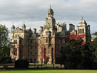
The Dukeries is an area of the county of Nottinghamshire so called because it contained four ducal seats. It is south of Worksop, which has been called its "gateway". The area was included within the ancient Sherwood Forest. The ducal seats were:
Ravenshead is a large village and civil parish in the Gedling district of Nottinghamshire, England. It borders Papplewick, Newstead Abbey and Blidworth, and is part of Nottinghamshire's Hidden Valleys area. According to the 2001 census it had a population of 5,636, reducing marginally to 5,629 at the 2011 census.

Colwick is a village and civil parish, in the Borough of Gedling of Nottinghamshire, England. It is situated to the east of Nottingham's city boundary, and forms the Colwick ward. At the time of the 2011 census, the village had a population of 2,829, falling to 2,778 at the 2021 census.
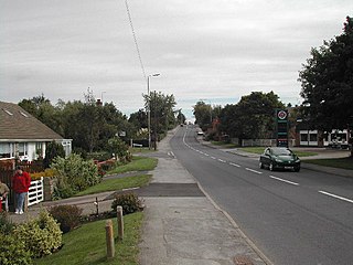
Lowdham is a village and civil parish in the Newark and Sherwood district of Nottinghamshire between Nottingham and Southwell. At the 2001 census it had a population of 2,832, increasing to 3,334 at the 2011 census, and falling to 3,247 at the 2021 census. Two main roads slicing through the village are the A6097 south-east to north-west and the A612 between Nottingham and Southwell.
Annesley is a village and civil parish in the Ashfield district of Nottinghamshire, England, between Hucknall and Kirkby-in-Ashfield. At the 2011 census, it had a population of 1,162, and this increased to 1,814 at the 2021 census.
Bilsthorpe is a village and civil parish in the Newark and Sherwood district of Nottinghamshire, England. According to the 2001 census it had a population of 3,076, increasing to 3,375 at the 2011 census, and dropping slightly to 3,365 at the 2021 census. It is located near the junction of the A614 and A617, around 5 miles south of Ollerton, 9 miles east of Mansfield and 6 miles north-west of Southwell.

Clipstone is a former mining village in the Newark and Sherwood district of Nottinghamshire, England. The population of the civil parish was 3,469 at the 2001 census, increasing to 4,665 at the 2011 census, and substantially more so to 6,185 at the 2021 census.
Bestwood Village is an village and civil parish in the Gedling district of Nottinghamshire. Until 1 April 2018 it was part of the civil parish of Bestwood St. Albans. The population count was 2,223 at the 2021 census. A small part of the village falls within the Ashfield district council area. There have been several new housing estates built recently including the redevelopment of the former Bayles and Whylie factory site which was a former glue mill. It is to the east of Hucknall and north of Bulwell. It is neighboured to the north by the village of Papplewick. It is also close to the Bestwood Park Estate which is in the City of Nottingham.

Linby is a small village and civil parish in Nottinghamshire, England. The nearest town is Hucknall which is immediately to the south-west. The village grew up around the mills on the River Leen, from which Linby's name is derived. Small streams known as Linby Docks run on both sides of the main street. The population of the civil parish at the 2011 census was 232, increasing to 676 at the 2021 census.

Gedling is a village and former civil parish which gives its name to the larger Borough of Gedling in Nottinghamshire, England. It lies 4 miles (6.4 km) north-east of Nottingham city centre. The parish was abolished in 1935 and absorbed into the urban district of Carlton, which in turn was abolished in 1974 on the creation of borough of Gedling. The population of the Gedling ward at the 2011 census was 6,817 and 111,787 for the district. Gedling was recorded in the Domesday Book and is still a distinct settlement, although residential, commercial and industrial growth in the wider borough of Gedling and the neighbouring city of Nottingham, boroughs of Broxtowe and Rushcliffe and district of Ashfield means it can be difficult to distinguish the village of Gedling from the nearby town of Carlton, with which it has become contiguous.

Hidden Valleys is a name, coined in 2004, used to describe an area of interesting historical and scenic value between the city of Nottingham and the town of Mansfield in the English ceremonial county of Nottinghamshire. Promotional literature and tourist information for the Hidden Valleys were created to encourage tourism in an area that had been blighted by industrial decline. Partners in the project were: Ashfield District Council; Gedling Borough Council; the East Midlands Development Agency; Nottinghamshire County Council; and the Coalfields Regeneration Trust. It was intended by the partners that the name would help the Ashfield area compete with the Peak District and Sherwood Forest.
Michael Shelton is a British sportsman who competed at the Summer Paralympic Games five times between 1960 and 1976 in snooker and other sports. He won six Paralympic medals, four gold, a silver and a bronze. He also won gold at the 1974 Commonwealth Paraplegic Games.


