Neys Provincial Park

Last updated
Neys Provincial Park
TBay Day 2040.JPG
Canada Ontario location map 2.svg
Red pog.svg
Location Thunder Bay District, Ontario, Canada
Nearest city Marathon
Coordinates 48°45′00″N86°35′00″W / 48.75000°N 86.58333°W / 48.75000; -86.58333
Area5,383 ha (13,300 acres)
Established1965
Governing body Ontario Parks

Neys Provincial Park is a natural environment-class provincial park on the north shore of Lake Superior, just west of Marathon, Ontario, Canada. This 5,383-hectare (13,300-acre) park includes the historic Coldwell Peninsula and the surrounding island system (added as part of Ontario's Living Legacy in 2000–2001), consisting of Pic Island, Detention Island, and the Sullivan Islands.

Contents

The ghost village of Coldwell, which lies just outside the park's east boundary, was home to an old railway and fishing community until the 1960s. All that remains of the village now are a few foundations, shipwrecks in the harbour and a cemetery. Within park boundaries is also the muse for Group of Seven member Lawren Harris, who in 1924 painted the now-famous image of Pic Island.

Flora and fauna in the park include many hardy species of subarctic plants and a rare herd of woodland caribou. The park is home to one of the most popular beaches on Lake Superior’s north shore and a model of a former German prisoner of war Camp at the Neys Visitor Centre.

Park sign on Highway 17, west of Marathon, Ontario Neys Provincial Park sign.jpg
Park sign on Highway 17, west of Marathon, Ontario

Natural features

Coldwell Complex

Neys Provincial Park is home to one of the hardest and rarest mineral complexes in North America. The Coldwell Complex began to form over 1 billion years ago when magma chambers formed beneath the surface causing surface swelling to occur. Eventually this swelling turned into an active volcano. 600 million years ago, the volcano walls became so large and heavy, they caved in on the volcano, acting as a plug. The magma then became trapped in the magma chamber where it settles and cools with other minerals causing the initial phases of the complex. 66 million years ago, glaciers began to recede, stripping away the top layers of the volcano. Today, the once hot magama chamber is exposed surface rock on the northern shore of Lake Superior. The park has a 2.5 km linear trail. There used to be interpretive plaques however they were removed in 2018 due to weathering inhibiting the legibility.

The inhospitable shore of Lake Superior

The shore of Lake Superior in Neys Provincial Park Lake Superior at Neys Provincial Park Ontario.jpg
The shore of Lake Superior in Neys Provincial Park

Lake Superior has been the reason for part of the early cultural heritage of Northern Ontario. It is also the cause of one of the most interesting parts of the natural heritage of the region as well. 7,500 years ago, the large Glaciers of the Laurentide Ice Sheet had finally melted away, filling in large bodies of water that covered 246,050 km². These bodies of water are the Great Lakes. The extremely cold and rough waters of Lake Superior have caused its rocky shores to be home to subarctic plant species. The following is a description of the region from the Natural Heritage Information Centre, Ontario Ministry of Natural Resources:

The rocky shore vegetation is an association of lichens, mosses and herbs that can tolerate the severe growing conditions of this site. These plants are able to survive in a microclimate that is cooler, windier and moister than those of nearby areas which are not as strongly influenced by Lake Superior. Lichens cover the bare, wave-washed rocks while the herbs are restricted to cracks and crevices in the rocks where soil has been able to accumulate. Many of these plants such as the butterwort, the three toothed cinquefoil, crowberry and bird’s eye primrose are not found elsewhere in the park and are part of a vegetation association known as an Arctic disjunct community, that is, the discrete association isolated from its main geographical location. Source: NHIC (OMNR)

The whaleback barge 115 wrecked on Pic Island in 1899. [1]

Forest vegetation

Birds Eye Primrose, Sub Arctic plant of Neys Provincial Park Birds Eye Primrose in Neys Provincial Park.jpg
Birds Eye Primrose, Sub Arctic plant of Neys Provincial Park

Neys is within the Central Boreal Forest Region of Ontario. As such it is home to a predominantly coniferous forest, however some boreal deciduous species can be found near waterways and former beaver dams. The park is also home to a large plantation of Red Pine. Park Naturalists theorise that these trees were planted by the Boy Scouts of Canada in the early-mid 1960s. The age of the trees and the fact that Boy Scouts did in fact plant nothing but Red Pines all across Canada as their "Centennial Project" in the 1960s backs this theory up. The Red Pines are not natural to the park eco-system, however, as they are planted in an inhospitable sand dune micro-environment of the park. This dune environment was previously disturbed (flattened and built upon) with the construction of the Neys Prisoner of War Camp (Neys Camp 100, Camp W).

The forests of Neys are home to a wide variety of species of flora and fauna. Some of the most common plant species include the Bunchberry, Labrador Tea, blueberry, bearberry, larch, mountain maple, and a wide variety of fungi. These plants are an attraction to such forest species as the Woodland Caribou, Moose, and the Black Bear.

Neys Camp 100

During World War II, 35,046 prisoners of war and Japanese-Canadians were interned in 26 main camps in Canada. The north shore of Lake Superior was the site of three such camps: Neys, Angler, and Red Rock.

Neys Camp 100 interned mostly German POWs, and some Japanese-Canadians between 1941-1946. The prisoners were forced to log in the Pic and Little Pic River valleys. [2]

German POWs were divided into categories: the "greys" who were largely ordinary soldiers, and the "blacks" who were considered die-hard Nazis, considered high risks for violence or escape attempts. Neys Camp 100 was one of Canada's nine camps which interned "black" prisoners. Hence the camp was enclosed by three barbed-wire fences and guard towers. [2]

At the end of World War II, Neys was turned into a processing camp for POWs in the northwestern Ontario region. It was then turned into a minimum-security work camp for civilian prisoners from the Thunder Bay area, and finally dismantled in the 1950s.

During the time of the internment camp, there were few, if any, escapes for two main reasons: in summer months, dense forests and heavy, black flies deterred prisoners from walking through the bush, and in the winter, sub-zero cold weather deterred prisoners from venturing out. Also, Lake Superior was a natural barrier, considering its size and frigid waters.

Logging and the Little Pic River

Ontario's forests have historically been used for logging purposes since the first White Pine loggers traversed the Ottawa Valley in the late 17th century. The Neys Region has a more modern logging heritage that is melded with park and national history along with the formation of the town of Marathon, Ontario.

Along the western border of Neys Provincial Park, runs the narrow, and shallow sandy bottomed Little Pic River. The river side was at one point home to dozens of logging camps in the middle of the 20th century. The timber operations in the region were run by an American company known as Marathon Pulp and Paper Mills INC., and a Canadian company of Fort William, the Pigeon Timber Company.

The logging process was quite simple. In the fall, a team of lumberjacks would arrive in the town of Coldwell via the Canadian Pacific Railway. They would then travel up the river to their respective logging camps where they would remain all winter until the spring. The loggers would work all day in woods cutting and felling trees. They would then stack them in cords and then have horses (mid-20th century saw tractors being used in some cases) drag the cords to the shores of the frozen Little Pic River. This process would go on all winter until the spring thaw. Once the rivers path was totally thawed, the loggers would begin the log drive. Using tools such as the peavey, the loggers would ride the logs down the river until they reached the mouth. At the mouth of the Little Pic River there were boom logs which were attached to chains. These chains were attached to rings that are still in the rocks edge at the Little Pic River picnic area. Once the boom rafts were filled with logs, the rafts would be closed and hauled away by tug boats to the Slate Islands where steamers would be waiting to load and transport the logs to the states for processing.

With the loss of the steam engines on the railway, the introduction of the sea lamprey into Lake Superior and the highly anticipated Trans Canada Highway's completion, Northern Ontario was dying. The federal government ordered that all timber which was removed from Canadian forests was to be processed in Canada. In an effort to save time and money, the Marathon Pulp and Paper company decided that it would open a mill and develop its own mill town along the Canadian Pacific Railway. The town was appropriately titled Marathon, by Canada Post. Eventually, the Little Pic River became obsolete as trucks could transport logs from anywhere to the mill with much more ease and less expense.

In the course of the years that the Little Pic River was vital to the Marathon Pulp and Paper company's operation, lumberjacks came in all shapes and sizes. The region saw loggers from southern Ontario, World War II German prisoners of war, and former Japanese interns who were staying at Neys Camp 100 all working for the companies logging on the Little Pic River. For example, in 1943, POWs accounted for 90,000 of the total 98,000 cords of wood harvested by the Pigeon Timber Company. [2]

Park services and facilities

A Park Interpreter on a Guided Hike in 2006 Neys Provincial Park interpreter 2006.jpg
A Park Interpreter on a Guided Hike in 2006

The park offers 144 campsites throughout four campgrounds within the park.

A number of trails through varying terrain exist within a short distance of the four campgrounds including "The Dune Trail" (1 km) through sand dunes and a beaver pond; "The Lookout Trail" (2.5 km, which takes hikers above the campground and has views of the park; "The Point Trail" (1 km), which follows the shore of Lake Superior to a rocky outcropping where boats used to ferry POW lumberjacks are beached; and the "Under the Volcano Trail" (2 km) which extends from the end of the "Point Trail" and follows the coast and includes information about the geological history of the area. "The Tower Trek Trail", a 10.5 km hike that takes approximately 4.5 hours for a round trip, allows access to a view of Pic Island. A coastal trail, currently in development and including some interior camping sites, is in development and can be found at the end of the "Under the Volcano Trail". The park also has two day-use areas, "Prisoner's Cove" and "The Little Pic".

Related Research Articles

<span class="mw-page-title-main">Lake Michigan</span> One of the Great Lakes of North America

Lake Michigan is one of the five Great Lakes of North America. It is the second-largest of the Great Lakes by volume and the third-largest by surface area, after Lake Superior and Lake Huron. To the east, its basin is conjoined with that of Lake Huron through the 3+12-mile (5.6-kilometer) wide, 295-foot deep Straits of Mackinac, giving it the same surface elevation as its easterly counterpart; the two are geologically a single lake.

<span class="mw-page-title-main">Algonquin Provincial Park</span> Provincial park in Ontario, Canada

Algonquin Provincial Park is an Ontario provincial park located between Georgian Bay and the Ottawa River, mostly within the Unorganized South Part of Nipissing District. Established in 1893, it is the oldest provincial park in Canada. Additions since its creation have increased the park to its current size of about 7,653 km2 (2,955 sq mi). The park is contiguous with several smaller, administratively separate provincial parks that protect important rivers in the area, resulting in a larger total protected area.

<span class="mw-page-title-main">Indiana Dunes National Park</span> United States National Park in Indiana

Indiana Dunes National Park is a United States national park located in northwestern Indiana managed by the National Park Service. It was authorized by Congress in 1966 as the Indiana Dunes National Lakeshore and was redesignated as the nation's 61st national park on February 15, 2019. The park runs for about 20 miles (32 km) along the southern shore of Lake Michigan and covers 15,349 acres (6,212 ha). Along the lakefront, the eastern area is roughly the lake shore south to U.S. 12 or U.S. 20 between Michigan City, Indiana, on the east and the Cleveland-Cliffs steel plant on the west. This areas conservation scheme is enhanced by the older Indiana Dunes State Park. To the west of the steel plant lies West Beach and a small extension south of the steel mill continues west along Salt Creek to Indiana 249. The western area is roughly the shoreline south to U.S. 12 between the Burns Ditch west to Broadway in downtown Gary, Indiana. In addition, there are several outlying areas, including Pinhook Bog, in LaPorte County to the east; the Heron Rookery in Porter County, the center of the park; and the Calumet Prairie State Nature Preserve and the Hobart Prairie Grove, both in Lake County, the western end of the park.

<span class="mw-page-title-main">Southwick Beach State Park</span> State park in Jefferson County, New York

Southwick Beach State Park is a New York State park that lies along an unusual stretch of sandy beach on the eastern shore of Lake Ontario. The park is 464 acres (188 ha) in size with a 3,500 foot (1,100 m) length of beach, and is visited annually by about 100,000 people. Immediately to the south is the Lakeview Wildlife Management Area, which extends the publicly accessible beach by several miles. They are in the Town of Ellisburg in Jefferson County, New York south of the lakeside community of Jefferson Park.

<span class="mw-page-title-main">Mattawa River</span> River in Ontario, Canada

The Mattawa River is a river in central Ontario, Canada. It flows east from Trout Lake east of North Bay and enters the Ottawa River at the town of Mattawa. Counting from the head of Trout Lake, it is 76 kilometres (47 mi) long. The river's name comes from the Algonquin word for "meeting of waterways".

<span class="mw-page-title-main">Pictured Rocks National Lakeshore</span> U.S. National Lakeshore on Lake Superior

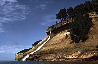
Pictured Rocks National Lakeshore is a U.S. National Lakeshore in the Upper Peninsula of Michigan, United States. It extends for 42 mi (68 km) along the shore of Lake Superior and covers 73,236 acres. The park has extensive views of the hilly shoreline between Munising and Grand Marais in Alger County, with picturesque rock formations, waterfalls, and sand dunes.

<span class="mw-page-title-main">Voyageurs National Park</span> National park in Minnesota, United States

Voyageurs National Park is an American national park in northern Minnesota near the city of International Falls established in 1975. The park's name commemorates the voyageurs—French-Canadian fur traders who were the first European settlers to frequently travel through the area. Notable for its outstanding water resources, the park is popular with canoeists, kayakers, other boaters, and fishermen. The Kabetogama Peninsula, which lies entirely within the park and makes up most of its land area, is accessible only by boat. To the east of the park lies the Boundary Waters Canoe Area Wilderness.

<span class="mw-page-title-main">Pic River</span> River in Ontario, Canada

The Pic River is a river in the east part of Thunder Bay District in northwestern Ontario, Canada. It flows from McKay Lake southeast of the community of Longlac and empties into Lake Superior southeast of the town of Marathon.

<span class="mw-page-title-main">Split Rock Lighthouse State Park</span> State park in Minnesota, United States

Split Rock Lighthouse State Park is a state park of Minnesota on the North Shore of Lake Superior. It is best known for the picturesque Split Rock Lighthouse, one of the most photographed lighthouses in the United States. Built by the United States Lighthouse Service in 1910, the lighthouse and some adjacent buildings have been restored and the Minnesota Historical Society operates them as a museum. The 2,200-acre (890 ha) state park offers a unique cart-in campground and scenic trails for hiking, cross-country skiing, and bicycling.

<span class="mw-page-title-main">Slate Islands (Ontario)</span> Islands in Lake Superior

The Slate Islands are a small archipelago in Lake Superior, Ontario, Canada, about 12 kilometres (7.5 mi) south of the town of Terrace Bay. The island group, consisting of 15 islands in total, was created by a meteorite impact which formed a crater about 32 km (20 mi) wide. In 1985, the Ontario government established the Slate Islands as a natural environment provincial park. The islands are notable for having Ontario's largest herd of boreal woodland caribou.

<span class="mw-page-title-main">Awenda Provincial Park</span> Provincial park in Ontario, Canada

Awenda Provincial Park is a provincial park in Tiny Township, Simcoe County in Central Ontario, Canada, located on a peninsula jutting into Georgian Bay north of Penetanguishene. The park occupies an area of 2,915 hectares and was established in 1975. It is classified as a Natural Environment Park and therefore all land is protected.

<span class="mw-page-title-main">Pukaskwa National Park</span> National park in Ontario, Canada

Pukaskwa National Park is a national park located south of the town of Marathon, Ontario in the Thunder Bay District of northern Ontario, Canada. Established in 1978, Pukaskwa is known for its vistas of Lake Superior and boreal forests. The park covers an area of 1,878 square kilometres (725 sq mi), and protects part of the longest undeveloped shoreline anywhere on the Great Lakes.

<span class="mw-page-title-main">North Shore (Lake Superior)</span> Geographic region in the United States and Canada

The North Shore of Lake Superior runs from Duluth, Minnesota, United States, at the western end of the lake, to Thunder Bay and Nipigon, Ontario, Canada, in the north, to Sault Ste. Marie, Ontario in the east. The shore is characterized by alternating rocky cliffs and cobblestone beaches, with forested hills and ridges through which scenic rivers and waterfalls descend as they flow to Lake Superior.

In April 1941, inmates at the Angler POW Camp near Neys Provincial Park on the north shore of Lake Superior planned the largest escape from a Canadian POW camp during World War II. The escape was the largest of its kind in Ontario, Canada.

<span class="mw-page-title-main">Temagami</span> Municipality in Ontario, Canada

Temagami, formerly spelled Timagami, is a municipality in northeastern Ontario, Canada, in the Nipissing District with Lake Temagami at its heart.

<span class="mw-page-title-main">Grand Portage State Forest</span> State Forest in Cook County, Minnesota

The Grand Portage State Forest is a state forest located near the community of Hovland in Cook County, in extreme northeastern Minnesota. The forest encloses Judge C. R. Magney State Park, Swamp River Wildlife Management Area, Hovland Woods Scientific and Natural Area, and Spring Beauty Hardwoods Scientific and Natural Area. It borders the Grand Portage Indian Reservation to the east, the Superior National Forest to the west, and Ontario to the north. The forest is named after the Grand Portage, a historic trade route between the Great Lakes and the Northwest.

<span class="mw-page-title-main">Central Canadian Shield forests</span> Taiga ecoregion of Ontario and Quebec, Canada

The Central Canadian Shield forests are a taiga ecoregion of Eastern Canada, as defined by the World Wildlife Fund (WWF) categorization system.

<span class="mw-page-title-main">Biigtigong Nishnaabeg</span> Indian reserve in Ontario, Canada

Biigtigong Nishnaabeg is an Ojibway (Anishinaabe) First Nation on the northern shore of Lake Superior. It is sometimes referred to as Ojibways of the Pic River First Nation. Pic River is not a signatory to the Robinson Superior treaty; however, they did petition, starting in 1879, for a reserve and the request was subsequently granted. The community is located on the northern shore of Lake Superior at the mouth of the Pic River 316.6-hectare (782-acre) and is called Pic River 50. In November 2007, their total registered population was 964 people, of which their on-reserve population was 480.

<span class="mw-page-title-main">Gooseberry River</span> River in Minnesota, United States

Gooseberry River is a 23-mile stream in Lake County, Minnesota, USA, draining into Lake Superior. It is known for its waterfalls, near its mouth in Gooseberry Falls State Park. The Gooseberry, like many of its neighboring streams, has an irregular discharge highly dependent on runoff from rain and snow melt. The region around the river was heavily forested and much logging took place during the early 20th century. The forest has since regrown and the falls and mouth of the river are now a thriving tourist destination.

The East English River Provincial Park is a linear waterway park in Kenora District, Ontario, Canada. It includes a 200 metres (660 ft) wide strip of land on both sides of the English River and its lakes, from the intersection of Highway 599 to Minnitaki Lake. It was established in 2003 to protect natural features, that are representative of the area, and high quality recreational canoe routes with over 30 sets of rapids. The park's notable features include white pine forest at the northern extent of its range, white elm and burr oak, caribou habitat and calving locations, fisheries, and archaeological sites.

References

  1. "0115". Bowling Green State University . Retrieved February 6, 2021.
  2. 1 2 3 Chisholm, B., and Gutsche, A. Superior: Under the Shadow of the Gods, Lynx Images, 1998, p. 166