Nokomis, Florida

Last updated

Nokomis, Florida
Sarasota County Florida Incorporated and Unincorporated areas Nokomis Highlighted.svg
Location in Sarasota County and the state of Florida
Coordinates: 27°7′25″N82°26′20″W / 27.12361°N 82.43889°W / 27.12361; -82.43889 [1]
Country United States
State Florida
County Sarasota
Area
[2]
  Total2.29 sq mi (5.94 km2)
  Land1.95 sq mi (5.05 km2)
  Water0.34 sq mi (0.89 km2)
Elevation
10 ft (3 m)
Population
 (2020)
  Total3,217
  Density1,650.59/sq mi (637.42/km2)
Time zone UTC−5 (Eastern (EST))
  Summer (DST) UTC−4 (EDT)
ZIP Codes
34274–34275
Area code 941
FIPS code 12-48875 [3]
GNIS feature ID0287754 [4]
View from Nokomis Beach, outside the Nokomis CDP, early on a summer morning Nokomis Beach.jpg
View from Nokomis Beach, outside the Nokomis CDP, early on a summer morning

Nokomis is an unincorporated town in Sarasota County and a census-designated place (CDP) along the Gulf Coast of Florida, United States, located south of Osprey and just north of Venice. The town has access to the coast through Nokomis Public Beach and Casey Key. The town's population was 3,217 at the 2020 census, up from 3,167 at the 2010 census. [5] It is part of the North Port Bradenton Sarasota, Florida Metropolitan Statistical Area.

Contents

History

Interior of the Knight Chapel, which was destroyed by the 1926 Hurricane. Interior of Knights Chapel - Nokomis, FL.jpg
Interior of the Knight Chapel, which was destroyed by the 1926 Hurricane.

The first white settlers in what is now known as Nokomis were the Knights and at least 3 other families who moved to the area in 1868. The Knights had initially raised cattle further inland during the American Civil War in an effort to avoid raids by the Union army. Following the end of hostilities, they moved closer to the shore, in the hopes that the climate of the coastal areas were better for their health. The area was initially called Horse and Chaise, which included modern day Venice. Knight donated the land for the first school and also helped build the first chapel. [6]

In 1917, Alfred F. Wrede established the first post office with the name of Nokomis southwest of the original Venice post office. The same year, orthopedic surgeon Dr. Fred Albee purchased 112 acres from the Sarasota-Venice Company. With Ellis W. Nash, Albee created the Nokomis subdivision by subdividing the property into 130 lots, with streets radiating from two inner avenue circles and the new asphalt highway, which eventually became U.S. 41. On U.S. 41, Albee and investors built the Pollyanna Inn, a 35-room hotel. [7]

The Florida guide, compiled in the late 1930s and first published in 1939, listed Nokomis's population as 79 and described it as "a suburb of Venice, […] separated from that town by Shackett Creek…" [8]

Geography

According to the United States Census Bureau, the Nokomis Census Designated Place (CDP) has a total area of 1.9 square miles (5.0 km2), of which 1.6 square miles (4.2 km2) is land and 0.31 square miles (0.8 km2), or 15.65%, is water. [5]

Nokomis includes approximately 2.5 miles of the Legacy Trail, including a water crossing at the Shakett Creek (Dona Bay) bridge.

Casey Key is a barrier island to the northwest of the CDP along the Gulf of Mexico, where there are luxurious beachfront houses lining the key. Casey Key is not part of any CDP. [9]

Demographics

Historical population
CensusPop.Note
1990 2,286
2000 2,253−1.4%
2010 3,16740.6%
2020 3,2171.6%
U.S. Decennial Census [10]

As of the census [3] of 2000, there were 3,334 people, 1,544 households, and 955 families residing in the CDP. The population density was 1,998.5 inhabitants per square mile (771.6/km2). There were 1,820 housing units at an average density of 1,091.0 per square mile (421.2/km2). The racial makeup of the CDP was 97.69% White, 0.60% African American, 0.24% Native American, 0.30% Asian, 0.27% from other races, and 0.90% from two or more races. Hispanic or Latino of any race were 1.86% of the population.

There were 1,544 households, out of which 19.8% had children under the age of 18 living with them, 49.8% were married couples living together, 8.0% had a female householder with no husband present, and 38.1% were non-families. 30.2% of all households were made up of individuals, and 13.7% had someone living alone who was 65 years of age or older. The average household size was 2.15 and the average family size was 2.64.

In the CDP, the population was spread out, with 17.1% under the age of 18, 5.3% from 18 to 24, 25.5% from 25 to 44, 28.3% from 45 to 64, and 23.8% who were 65 years of age or older. The median age was 46 years. For every 100 females, there were 100.6 males. For every 100 females age 18 and over, there were 97.4 males.

The median income for a household in the CDP was $34,699, and the median income for a family was $37,731. Males had a median income of $27,209 versus $21,563 for females. The per capita income for the CDP was $22,077. About 8.6% of families and 12.9% of the population were below the poverty line, including 13.4% of those under age 18 and 10.6% of those age 65 or over.

Related Research Articles

<span class="mw-page-title-main">Grove City, Florida</span> Census-designated place in Florida, United States

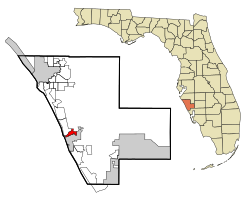
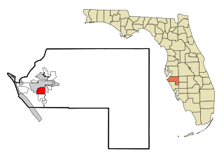
Grove City is an unincorporated community and census-designated place (CDP) in Charlotte County, Florida, United States. The population was 2,174 at the 2020 census, up from 1,804 at the 2010 census. It is part of the Punta Gorda, FL Metropolitan Statistical Area, included in the North Port-Bradenton, Florida Combined Statistical Area.

<span class="mw-page-title-main">Manasota Key, Florida</span> Census-designated place in Florida, United States

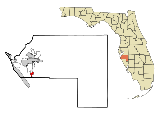
Manasota Key is a census-designated place (CDP) consisting mainly of the community of Englewood Beach in Charlotte County, Florida, United States. The population of the CDP was 1,326 at the 2020 census, up from 1,229 at the 2010 census. It is part of the Punta Gorda, Florida Metropolitan Statistical Area, included in the North Port-Bradenton, Florida Combined Statistical Area.

<span class="mw-page-title-main">Bayport, Florida</span> Census-designated place in Florida, United States

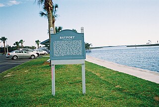
Bayport is an unincorporated community and census-designated place (CDP) in Hernando County, Florida, United States. The population was 43 at the 2010 census.

<span class="mw-page-title-main">Bayshore Gardens, Florida</span> Census-designated place in Florida, United States

Bayshore Gardens is a census-designated place (CDP) and planned community in Manatee County, Florida, United States. The population was 19,904 at the 2020 census, up from 16,323 in 2010. It is part of the North Port-Bradenton-Sarasota, Florida Metropolitan Statistical Area.

<span class="mw-page-title-main">South Bradenton, Florida</span> Census-designated place in Florida, United States

South Bradenton is an unincorporated community and census-designated place (CDP) in Manatee County, Florida, United States. The population was 26,858 at the 2020 census, up from 22,178 in 2010. It is part of the North Port–Bradenton–Sarasota, Florida Metropolitan Statistical Area.

<span class="mw-page-title-main">West Bradenton, Florida</span> Census-designated place in Florida, United States

West Bradenton is an unincorporated area and census-designated place (CDP) in Manatee County, Florida, United States. The population was 4,247 at the 2020 census, up from 4,192 at the 2010 census. It is part of the North Port–Bradenton–Sarasota, Florida Metropolitan Statistical Area.

<span class="mw-page-title-main">West Samoset, Florida</span> Census-designated place in Florida, United States

West Samoset is an unincorporated area and census-designated place (CDP) in Manatee County, Florida, United States. The population was 6,482 at the 2020 census, up from 5,583 in 2010. It is part of the North Port–Bradenton–Sarasota, Florida Metropolitan Statistical Area.

<span class="mw-page-title-main">Whitfield, Manatee County, Florida</span> Census-designated place in Florida, United States

Whitfield, also known as Whitfield Estates, is an unincorporated community and census-designated place (CDP) in Manatee County, Florida, United States. As of the 2020 census it had a population of 2,989, up from 2,882 at the 2010 census. It is part of the North Port–Bradenton–Sarasota, Florida Metropolitan Statistical Area. It receives its mail from the Sarasota post office located in Sarasota County.

<span class="mw-page-title-main">Orlo Vista, Florida</span> Census-designated place & Unincorporated community in Florida, United States

Orlo Vista is an unincorporated community and census-designated place in Orange County, Florida, United States. While the spelling "Orlo Vista" is used by the U.S. Postal Service, the community is shown as Orlovista on federal maps. The population of the Orlovista census-designated place was 6,123 at the 2010 census. It is part of the Orlando–Kissimmee Metropolitan Statistical Area. The boundaries of the Orlovista CDP are West Colonial Drive on the north, Pine Hills Road on the east, Old Winter Garden Road and Carter Street at the Orlando city limits on the south, and Hiawassee Road on the west.

<span class="mw-page-title-main">Desoto Lakes, Florida</span> Census-designated place in Florida, United States

Desoto Lakes is a census-designated place (CDP) in Sarasota County, Florida, United States. The population was 2,137 at the 2020 US census, down from 3,646 at the 2010 US Census. It is part of the North Port–Bradenton–Sarasota, Florida Metropolitan Statistical Area.

<span class="mw-page-title-main">Gulf Gate Estates, Florida</span> Census-designated place in Florida, United States

Gulf Gate Estates is a census-designated place (CDP) in Sarasota County, Florida, United States. The population was 11,118 at the 2020 census, up from 10,911 at the 2010 census. It is part of the North Port–Bradenton–Sarasota, Florida Metropolitan Statistical Area.

<span class="mw-page-title-main">Lake Sarasota, Florida</span> Census-designated place in Florida, United States

Lake Sarasota is a census-designated place (CDP) in Sarasota County, Florida, United States. The population was 3,979 at the 2020 census, down from 4,679 at the 2010 census. It is part of the North Port–Bradenton–Sarasota, Florida Metropolitan Statistical Area.

<span class="mw-page-title-main">North Sarasota, Florida</span> Census-designated place in Florida, United States

North Sarasota is a census-designated place (CDP) in Sarasota County, Florida, United States. The population was 2,418 at the 2020 census, down from 6,982 at the 2010 census. It is part of the North Port–Bradenton–Sarasota, Florida Metropolitan Statistical Area.

<span class="mw-page-title-main">Sarasota Springs, Florida</span> Census-designated place in Florida, United States

Sarasota Springs is a census-designated place (CDP) in Sarasota County, Florida, United States. The population was 12,521 at the 2020 census, down from 14,395 at the 2010 census. It is part of the North Port–Bradenton–Sarasota, Florida Metropolitan Statistical Area.

<span class="mw-page-title-main">South Sarasota, Florida</span> Census-designated place in Florida, United States

South Sarasota is a census-designated place (CDP) in Sarasota County, Florida, United States. The population was 5,133 at the 2020 census, up from 4,950 at the 2010 census. It is part of the North Port–Bradenton–Sarasota, Florida Metropolitan Statistical Area.

<span class="mw-page-title-main">South Venice, Florida</span> Census-designated place in Florida, United States

South Venice is a census-designated place (CDP) in Sarasota County, Florida, United States. The population was 15,619 at the 2020 census, up from 13,949 at the 2010 census. It is part of the North Port–Bradenton–Sarasota, Florida Metropolitan Statistical Area.

<span class="mw-page-title-main">Southgate, Florida</span> Census-designated place in Florida, United States

Southgate is a census-designated place (CDP) in Sarasota County, Florida, United States. The population was 6,287 at the 2020 census, down from 7,173 at the 2010 census. It is part of the North Port–Bradenton–Sarasota, Florida Metropolitan Statistical Area.

<span class="mw-page-title-main">Vamo, Florida</span> Census-designated place in Florida, United States

Vamo is a census-designated place (CDP) in Sarasota County, Florida, United States. The population was 2,822 at the 2020 census, down from 4,727 at the 2010 census. It is part of the North Port–Bradenton–Sarasota, Florida Metropolitan Statistical Area.

<span class="mw-page-title-main">Venice Gardens, Florida</span> Census-designated place in Florida, United States

Venice Gardens is a census-designated place (CDP) in Sarasota County, Florida, United States. The population was 3,402 at the 2020 census, down from 7,104 at the 2010 census. It is part of the North Port–Bradenton–Sarasota, Florida Metropolitan Statistical Area.

Wedgefield is a census-designated place (CDP) in Sumter County, South Carolina, United States. The population was 1,544 at the 2000 census.

References

  1. "US Gazetteer files: 2010, 2000, and 1990". United States Census Bureau. February 12, 2011. Retrieved April 23, 2011.
  2. "2020 U.S. Gazetteer Files". United States Census Bureau. Retrieved October 31, 2021.
  3. 1 2 "U.S. Census website". United States Census Bureau . Retrieved January 31, 2008.
  4. "US Board on Geographic Names". United States Geological Survey. October 25, 2007. Retrieved January 31, 2008.
  5. 1 2 "Geographic Identifiers: 2010 Demographic Profile Data (G001): Nokomis CDP, Florida". U.S. Census Bureau, American Factfinder. Archived from the original on February 12, 2020. Retrieved April 15, 2013.
  6. Berry, Joan (2008). The Homesteaders: Early Settlers of Nokomis and Laurel (Revised ed.). pp. 15–16.
  7. "FOUR: HISTORICAL AND ARCHAEOLOGICAL RESOURCES" (PDF).
  8. Federal Writers' Project (1947). Florida: A Guide to the Southernmost State (5th ed.). New York: Oxford University Press. p. 395.
  9. "P.L. 94-171 County Block Map (2010 Census): Sarasota County, FL". U.S. Census Bureau. December 11, 2011. Retrieved April 15, 2013.
  10. "Census of Population and Housing". Census.gov. Retrieved June 4, 2016.