Norton Parish, New Brunswick

Last updated

Norton Parish
Kings County NB - Norton Parish.png
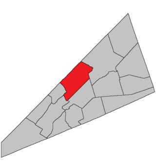
Location within Kings County, New Brunswick.
Coordinates: 45°50′N64°35′W / 45.84°N 64.59°W / 45.84; -64.59
Country Flag of Canada (Pantone).svg  Canada
Province Flag of New Brunswick.svg  New Brunswick
County Queens County
Erected1795
Area
[1]
  Land144.77 km2 (55.90 sq mi)
Population
 (2021) [1]
  Total1,325
  Density9.2/km2 (24/sq mi)
  Change 2016-2021
Increase2.svg 1.8%
  Dwellings
550
Time zone UTC-4 (AST)
  Summer (DST) UTC-3 (ADT)
Figures do not include portions within the town of Hampton and the village of Norton

Norton is a geographic parish in Kings County, New Brunswick, Canada. [2]

Contents

Prior to the 2023 governance reform, it was divided between the town of Hampton, [3] the village of Norton, [3] and the local service district of the parish of Norton, [4] all of which were members of Kings Regional Service Commission (RSC8). [5]

Origin of name

Norton may have been named for Norton, Massachusetts, near Taunton, which was the original home of many of the first settlers to this area.

Notable is that the names of Kings County's pre-1800 parishes all occur in both New Jersey and North Carolina. [6]

History

Norton was erected in 1795 [7] from Sussex Parish and Kingston Parish.

In 1844 the boundary with Kingston was adjusted. [8]

Writer Emily Elizabeth Shaw Beavan worked in the parish as a young teacher. [9]

Boundaries

Norton Parish is bounded: [2] [10] [11] [12]

Communities

Communities at least partly within the parish; [10] [11] [12] bold indicates an incorporated municipality; italics indicate a name no longer in official use

Bodies of water

Bodies of water [lower-alpha 3] at least partly in the parish: [10] [11] [12]

Demographics

Parish population total does not include Hampton and the village of Norton

Access Routes

Highways and numbered routes that run through the parish, including external routes that start or finish at the parish limits: [17]

See also

Notes

  1. By the magnet of 1795, [7] when declination in the area was between 15º and 16º west of north. [13]
  2. The old Westmorland Road was discontinued so long ago that it does not appear on the province's cadastral grant maps.
  3. Not including brooks, ponds or coves.

Related Research Articles

<span class="mw-page-title-main">Springfield Parish, New Brunswick</span> Parish in New Brunswick, Canada

Springfield is a geographic parish in Kings County, New Brunswick, Canada.

<span class="mw-page-title-main">Baker Brook Parish, New Brunswick</span> Parish in New Brunswick, Canada

Baker Brook is a geographic parish in Madawaska County, New Brunswick, Canada.

<span class="mw-page-title-main">Saint-Joseph Parish, New Brunswick</span> Parish in New Brunswick, Canada

Saint-Joseph is a geographic parish in Madawaska County, New Brunswick, Canada.

<span class="mw-page-title-main">Saint-Basile Parish, New Brunswick</span> Parish in New Brunswick, Canada

Saint-Basile is a geographic parish in Madawaska County, New Brunswick, Canada.

<span class="mw-page-title-main">Rivière-Verte Parish, New Brunswick</span> Parish in New Brunswick, Canada

Rivière-Verte is a geographic parish in Madawaska County, New Brunswick, Canada.

<span class="mw-page-title-main">Sainte-Anne Parish, New Brunswick</span> Parish in New Brunswick, Canada

Sainte-Anne is a geographic parish in Madawaska County, New Brunswick, Canada.

<span class="mw-page-title-main">Notre-Dame-de-Lourdes Parish, New Brunswick</span> Parish in New Brunswick, Canada

Notre-Dame-de-Lourdes is a geographic parish in Madawaska County, New Brunswick, Canada.

<span class="mw-page-title-main">Saint-Léonard Parish, New Brunswick</span> Parish in New Brunswick, Canada

Saint-Léonard is a geographic parish in Madawaska County, New Brunswick, Canada.

<span class="mw-page-title-main">Carleton Parish, New Brunswick</span> Parish in New Brunswick, Canada

Carleton is a geographic parish in Kent County, New Brunswick, Canada.

<span class="mw-page-title-main">Wellington Parish, New Brunswick</span> Parish in New Brunswick, Canada

Wellington is a geographic parish in Kent County, New Brunswick, Canada.

<span class="mw-page-title-main">Sainte-Marie Parish, New Brunswick</span> Parish in New Brunswick, Canada

Saint-Marie, is a geographic parish in Kent County, New Brunswick, Canada.

<span class="mw-page-title-main">Elgin Parish, New Brunswick</span> Parish in New Brunswick, Canada

Elgin is a geographic parish in the interior of Albert County, New Brunswick, Canada, the only one of the county's parishes that does not border either the Bay of Fundy or the Petitcodiac River.

<span class="mw-page-title-main">Cardwell Parish, New Brunswick</span> Parish in New Brunswick, Canada

Cardwell is a geographic parish in Kings County, New Brunswick, Canada, located on the eastern border of the county.

<span class="mw-page-title-main">Studholm Parish, New Brunswick</span> Parish in New Brunswick, Canada

Studholm is a geographic parish in Kings County, New Brunswick, Canada.

<span class="mw-page-title-main">Sussex Parish, New Brunswick</span> Parish in New Brunswick, Canada

Sussex is a geographic parish in Kings County, New Brunswick, Canada.

<span class="mw-page-title-main">Upham Parish, New Brunswick</span> Parish in New Brunswick, Canada

Upham is a geographic parish in Kings County, New Brunswick, Canada.

<span class="mw-page-title-main">Hampton Parish, New Brunswick</span> Parish in New Brunswick, Canada

Hampton is a geographic parish in Kings County, New Brunswick, Canada.

<span class="mw-page-title-main">Westfield Parish, New Brunswick</span> Parish in New Brunswick, Canada

Westfield is a geographic parish in Kings County, New Brunswick, Canada.

<span class="mw-page-title-main">Kingston Parish, New Brunswick</span> Parish in New Brunswick, Canada

Kingston is a geographic parish in Kings County, New Brunswick, Canada.

<span class="mw-page-title-main">Dumbarton Parish, New Brunswick</span> Parish in Canada

Dumbarton is a geographic parish in Charlotte County, New Brunswick, Canada, located inland north of St. George and south of Harvey.

References

  1. 1 2 "Census Profile". Statistics Canada. 26 October 2022. Retrieved 30 October 2022.
  2. 1 2 "Chapter T-3 Territorial Division Act". Government of New Brunswick. Retrieved 13 November 2020.
  3. 1 2 "New Brunswick Regulation 85-6 under the Municipalities Act (O.C. 85-45)". Government of New Brunswick. Retrieved 19 July 2020.
  4. "New Brunswick Regulation 84-168 under the Municipalities Act (O.C. 84-582)". Government of New Brunswick. Retrieved 19 July 2020.
  5. "Communities in each of the 12 Regional Service Commissions (RSC) / Les communautés dans chacune des 12 Commissions de services régionaux (CSR)" (PDF), Government of New Brunswick, July 2017, retrieved 2 February 2021
  6. "Domestic Names". U.S. Geological Survey. Retrieved 17 April 2021.
  7. 1 2 "35 Geo. III c. 3 An Act in addition to an Act intitled, 'An Act for the better Ascertaining and Confirming the Boundaries of the several Counties within this Province, and for subdividing them into Towns or Parishes.'". Acts of the General Assembly of His Majesty's Province of New-Brunswick, Passed in the Year 1795. Fredericton: Government of New Brunswick. 1795. pp. 338–340. Retrieved 27 March 2021.
  8. "7 Vic. c. 24 An Act to alter the Division Line between the Parishes of Kingston and Norton, in King's County.". Acts of the General Assembly of Her Majesty's Province of New Brunswick, Passed in the Year 1844. Fredericton: Government of New Brunswick. 1844. p. 24. Retrieved 27 March 2021.
  9. "SHAW, EMILY ELIZABETH". Home – Dictionary of Canadian Biography. 25 September 2019. Retrieved 25 September 2019.
  10. 1 2 3 "No. 140". Provincial Archives of New Brunswick. Department of Natural Resources and Energy Development. Retrieved 14 June 2021. Remainder of parish on maps 149 and 150 at same site.
  11. 1 2 3 "414" (PDF). Transportation and Infrastructure. Government of New Brunswick. Retrieved 14 June 2021. Remainder of parish on mapbooks 431, 432, 446, and 447 at same site.
  12. 1 2 3 "Search the Canadian Geographical Names Database (CGNDB)". Government of Canada. Retrieved 14 June 2021.
  13. "Historical Magnetic Declination". National Oceanic and Atmospheric Administration. Retrieved 1 March 2021.
  14. Statistics Canada: 2001, 2006 census
  15. 2011 Statistics Canada Census Profile: Norton Parish, New Brunswick
  16. 1 2 "Census Profile, 2016 Census: Norton, Parish [Census subdivision], New Brunswick". Statistics Canada. Retrieved 30 August 2019.
  17. Atlantic Canada Back Road Atlas ISBN   978-1-55368-618-7


45°36′26″N65°42′53″W / 45.607193°N 65.714808°W / 45.607193; -65.714808 (Norton Parish, New Brunswick)