Ohio State Route 521

Last updated

OH-521.svg

State Route 521
OH 521 map.svg
Route information
Maintained by ODOT
Length 13.62 mi [1] (21.92 km)
Existed 1937 – present
Major junctions
West endOH-37.svg SR 37 in Delaware
East endOH-656.svg SR 656 in Olive Green
Location
Counties Delaware
Highway system
OH-520.svg SR 520 SR 522 OH-522.svg

State Route 521 (SR 521) is an eastwest state highway in central Ohio. Existing entirely within Delaware County, the western terminus of SR 521 is at SR 37 in Delaware. Its eastern terminus is at SR 656 in the hamlet of Olive Green, located approximately five miles (8.0 km) north of Sunbury.

A state highway, state road, or state route is usually a road that is either numbered or maintained by a sub-national state or province. A road numbered by a state or province falls below numbered national highways in the hierarchy. Roads maintained by a state or province include both nationally numbered highways and un-numbered state highways. Depending on the state, "state highway" may be used for one meaning and "state road" or "state route" for the other.

Ohio State of the United States of America

Ohio is a Midwestern state in the Great Lakes region of the United States. Of the fifty states, it is the 34th largest by area, the seventh most populous, and the tenth most densely populated. The state's capital and largest city is Columbus.

Delaware County, Ohio County in the United States

Delaware County is a county in the U.S. state of Ohio. As of the 2010 census, the population was 174,214. Its county seat is Delaware, Ohio. The county was formed in 1808 from Franklin County, Ohio. Both the county and its seat are named after the Delaware Indian tribe.

Contents

Route description

Kingston Township hall, east of Kilbourne Kingston Township Hall on SR 521.jpg
Kingston Township hall, east of Kilbourne

The Ohio Department of Transportation defines SR 521 as beginning at the intersection of SR 37/Central Avenue and Sandusky Street in downtown Delaware. SR 521 follows Sandusky Street south two blocks to U.S. Route 36 (US 36) or William Street, and then following US 36 easterly through Delaware, passes the partial interchange with US 23, across the Olentangy River along the brief concurrency US 36 has with US 42. Beyond this point, SR 37 converges with the SR 521 and US 36 at a signalized intersection on the east side of the city. The three highways run together until another signalized intersection where SR 521 breaks off towards the northeast. This 1.76-mile (2.83 km) stretch of SR 521 is not explicitly signed in the field. [2] [3] [4]

Ohio Department of Transportation government agency

The Ohio Department of Transportation is the administrative department of the Ohio state government responsible for developing and maintaining all state and federal roadways in the state of Ohio with exception of the Ohio Turnpike. In addition to highways, the department also helps develop public transportation and public aviation programs. ODOT is headquartered in Columbus, Ohio. Formerly, under the direction of Michael Massa, ODOT had also first initiated a series of interstate-based Travel Information Centers for the traveling public, which was later transferred to local sectors. The Director of Transportation is part of the Governor's Cabinet.

U.S. Route 23 in Ohio highway in Ohio

U.S. Route 23 (US 23) is a United States Numbered Highway that runs from Jacksonville, Florida, to Mackinaw City, Michigan. In the state of Ohio, it is a major north–south state highway that runs from the Kentucky border at Portsmouth to the Michigan border at Sylvania.

Olentangy River River in Ohio, United States of America

The Olentangy River is a 97-mile-long (156 km) tributary of the Scioto River in Ohio.

The aforementioned signalized intersection with US 36/SR 37 on the east side of Delaware marks the start of the signed portion of SR 521. The state highway departs the city of Delaware heading northeast into Brown Township amid a vastness of open farmland and the occasional home, passing underneath the CSX railway prior to passing T-intersections with Harris Road and Skinner Road. At the County Home Road intersection, SR 521 turns east, and enters the hamlet of Kilbourne, where it passes amid some homes and businesses, as well as intersects Old State Road. East of there, SR 521 passes through woodlands as it crosses over Alum Creek and passes its intersection with Hogback Road. As it re-enters primarily open farmland, SR 521 passes Kilbourne Road, then follows an S-curve to the southeast. Resuming an easterly trek, after passing the unusually-named 3 Bs & K Road, SR 521 crosses into Kingston Township. Next, the state highway crosses Galena Road, then passes over Interstate 71 without an interchange. Continuing east through farm country and passing the occasional house, State Route 521 passes through intersections with Carter's Corners Road and Blue Church Road, then turns to the east-southeast prior to entering Porter Township and arriving at its junction with SR 61. Heading due from SR 61, SR 521 passes through a forested landscape, and crosses the Big Walnut Creek prior to coming to an end in the hamlet of Olive Green at the SR 656 intersection. Continuing to the east of SR 656 after SR 521 terminates is Olive Green Road. [5]

Brown Township, Delaware County, Ohio Township in Ohio, United States

Brown Township is one of the eighteen townships of Delaware County, Ohio, United States. As of the 2010 census the population was 1,416.

Kilbourne, Ohio Census-designated place in Ohio, United States

Kilbourne is a census-designated place in eastern Brown Township, Delaware County, Ohio, United States. As of the 2010 census it had a population of 139. The community has a post office with the ZIP code of 43032. It lies along State Route 521.

Alum Creek (Ohio) river in the United States of America

Alum Creek is 58-mile (93 km) long creek that runs north to south in central Ohio. The creek originates in Morrow County and then flows through Delaware County and finally into Franklin County, where it ends at Big Walnut Creek, which drains into the Scioto River. In 1974, the Army Corps of Engineers completed the Alum Creek Reservoir near the middle portion of the creek length. This reservoir "has a surface area of 3,387 acres of water and was created to ensure a water supply for the city of Columbus, provide flood control for the area south of the reservoir, and yield recreational opportunities."

The portion of SR 521 concurrent with US 36 east of US 23 is included within the National Highway System. [6]

National Highway System (United States) highway system in the United States

The National Highway System (NHS) is a network of strategic highways within the United States, including the Interstate Highway System and other roads serving major airports, ports, rail or truck terminals, railway stations, pipeline terminals and other strategic transport facilities. Altogether, it constitutes the largest highway system in the world.

History

SR 521 was established in 1937 along the routing that it occupies to this day, and has not seen any significant changes since its inception. [7] [8]

Major intersections

The entire route is in Delaware County.

Locationmi [1] kmDestinationsNotes
Delaware 0.000.00OH-37.svgUS 23.svg SR 37 (Central Avenue) to US 23 north / North Sandusky StreetWestern terminus (designated)
0.180.29US 36.svg US 36 west (West William Street) / South Sandusky StreetWestern end of US 36 concurrency
0.420.68US 23.svgUS 42.svg US 23 / US 42 southInterchange; western end of US 42 concurrency
0.651.05US 42.svgUS 23.svg US 42 north (Lake Street) to US 23 northEastern end of US 42 concurrency
1.252.01OH-37.svgUS 23.svgUS 42.svg SR 37 west (East Central Avenue) to US 23 / US 42 northWestern end of SR 37 concurrency
1.762.83US 36.svgOH-37.svgI-71.svg US 36 / SR 37 east (Sunbury Road) to I-71 Eastern end of US 36 / SR 37 concurrency; western terminus (signed)
Porter Township 12.9120.78OH-61.svg SR 61  Sunbury, Mount Gilead
13.6221.92OH-656.svg SR 656 / CR 52 (Olive Green Road)Eastern terminus
1.000 mi = 1.609 km; 1.000 km = 0.621 mi

Related Research Articles

Ohio State Route 385 highway in Ohio

State Route 385 is an east–west state highway in the western portion of Ohio. The western terminus of State Route 385 is at U.S. Route 33 in New Hampshire, at a signalized intersection that doubles as the southern terminus of State Route 196. State Route 385's eastern terminus is at State Route 117 in the unincorporated community of Roundhead, less than two blocks northwest of State Route 117's junction with State Route 235.

Ohio State Route 300 highway in Ohio

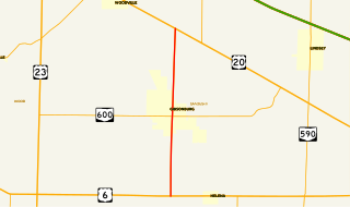
State Route 300 is a 6.33-mile (10.19 km) long north–south state highway in northwestern Ohio, a U.S. state. The southern terminus of SR 300 is at a T-intersection with U.S. Route 6 (US 6) approximately 1.50 miles (2.41 km) west of the village of Helena. Its northern terminus is at US 20 just over 2.50 miles (4.02 km) southeast of Woodville.

Ohio State Route 728 highway in Ohio

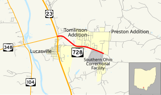
State Route 728 is a short east–west state highway situated in south-central Ohio. At a length of just under 2 miles (3.2 km), the state highway is a spur route that provides access to the Southern Ohio Correctional Facility. The western terminus of SR 728 is at a signalized intersection with U.S. Route 23 (US 23) in Lucasville that doubles as the eastern terminus of SR 348. Its eastern terminus is just east of the Southern Ohio Correctional Facility, at the intersection of Lucasville-Minford Road and Lang Lane (CR 180).

Ohio State Route 101 highway in Ohio

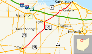
State Route 101 (SR 101) is a southwest-northeast state highway in the north central portion of the U.S. state of Ohio. Its western terminus is at the junction of SR 18 and SR 53 in Tiffin; it runs concurrently with SR 18 for about one mile (1.6 km). Its eastern terminus is at the junction of U.S. Route 6 (US 6) and SR 4 in Sandusky; it runs concurrently with US 6 for just over one and a half miles (2.4 km) to its western terminus.

Ohio State Route 671 highway in Ohio

State Route 671 is an east-west state highway in the southern portion of Ohio. Existing entirely within Vinton County, the western terminus of this short connector route is at SR 327 three miles (4.8 km) northeast of the hamlet of Londonderry. Its eastern terminus is at U.S. Route 50 (US 50) in the unincorporated community of Ratcliffburg.

Ohio State Route 510 highway in Ohio

State Route 510 is a north–south state highway in the northern portion of Ohio. The entirety of SR 510 lies within Sandusky County. Its southern terminus is at SR 101 in Clyde, and its northern terminus is at U.S. Route 6 (US 6) between Fremont and Sandusky.

Ohio State Route 745 highway in Ohio

State Route 745 (SR 745) is a state route in central Ohio that runs in a north-northwesterly direction along the west bank of the Scioto River. Its southern terminus is at the concurrency of U.S. Route 33 (US 33) and SR 161 in Dublin, and it runs for approximately ten miles (16 km) to Concord Township in Delaware County, where it arrives at its northern terminus at the concurrency of US 42 and SR 257. SR 745 was designated in 1937, and its routing has not changed since.

Ohio State Route 515 highway in Ohio

State Route 515 is a north-south state highway located in east-central Ohio. Existing entirely within the northeastern portion of Holmes County in Ohio's Amish Country, SR 515 has its southern terminus at a signalized intersection with SR 39 in the unincorporated community of Walnut Creek. Its northern terminus is at a T-intersection with U.S. Route 62 (US 62) one mile (1.6 km) southwest of the hamlet of Winesburg.

Ohio State Route 130 highway in Ohio

State Route 130 (SR 130) is a short east–west state route in southwestern Ohio. The entirety of SR 130 lies within Butler County. SR 130 has its western terminus at a signalized intersection with U.S. Route 27 (US 27) in McGonigle. Its eastern terminus is also at a signalized intersection, this time at SR 177 in the extreme northwestern corner of Hamilton. For its entire length, SR 130 is alternately known as Old Oxford Road.

Ohio State Route 605 highway in Ohio

State Route 605 is a 9.38-mile-long (15.10 km) north–south state highway in central Ohio. The southern terminus of SR 605 is at a signalized intersection with U.S. Route 62 in the northeastern Columbus suburb of New Albany. Its northern terminus is also at SR 37, a signalized intersection approximately 3 miles (4.8 km) southeast of Sunbury. The route was designated in 1937, and the northern terminus was moved in 1994.

Ohio State Route 257 highway in Ohio

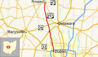
State Route 257 is a 26.19-mile (42.15 km) north - south state highway in the central portion of the U.S. state of Ohio. The highway's southern terminus is in the northwestern Columbus suburb of Dublin at a roundabout intersection with U.S. Route 33 and SR 161. This mainly two-lane highway follows the eastern side of the Scioto River from Dublin to its junction with US 42. After crossing over the river with the U.S. highway, SR 257 parallels the river's western bank. SR 257 has its northern terminus at a T-intersection with SR 47 on the western village limits of Prospect. SR 257 was created in 1926, and extended in 1935 and 1937.

Ohio State Route 768 highway in Ohio

State Route 768 is a 1.7-mile (2.7 km) long north–south state highway in the central portion of the U.S. state of Ohio. The highway runs from its southern terminus at a signalized intersection with U.S. Route 36 (US 36) in the eastern portion of the city of Mount Vernon to its northern terminus at SR 3 approximately 1.25 miles (2.01 km) north of the Mount Vernon city limits.

Ohio State Route 181 highway in Ohio

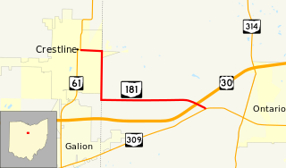
State Route 181 (SR 181) is a 4.46-mile (7.18 km) long east–west state highway in the northern portion of the U.S. state of Ohio. The western terminus of SR 181 is at a signalized intersection with SR 61 in downtown Crestline, and its eastern terminus is at a T-intersection with SR 309 approximately one mile (1.6 km) west of Ontario.

Ohio State Route 762 highway in Ohio

State Route 762 is an east–west state highway in central Ohio, a U.S. state. The highway has its western terminus at a signalized intersection with the concurrency of U.S. Route 62 and SR 3 just 0.25 miles (0.40 km) south of the village limits of Harrisburg. SR 762's eastern terminus is at an intersection of Pickaway County Route 385 near the Rickenbacker International Airport.

Ohio State Route 625 highway in Ohio

State Route 625 is a state route in northeastern Ohio that exists entirely within Mahoning County. The southern terminus of SR 625 is at U.S. Route 224 (US 224) near Boardman, and its northern terminus is at US 62 in the southwestern portion of Youngstown. SR 625 is currently signed north–south, but in the past was signed east–west.

Ohio State Route 111 highway in Ohio

State Route 111 (SR 111) is a 31.49-mile (50.68 km) state route that runs between the Indiana state line and Defiance in the US state of Ohio. Most of the route is a rural two-lane highway and passes through both farmland and residential properties. For some of its path, SR 111 runs generally parallel to the north of the Auglaize River.

U.S. Route 30 in Ohio highway in Ohio

U.S. Route 30 (US 30) is a United States Numbered Highway that runs from Astoria, Oregon, to Atlantic City, New Jersey. In the US state of Ohio, it is a major, 245-mile-long (394 km), east–west highway that runs through the northern section of Ohio. Overall, the highway runs through rural areas of the state dominated by farm fields or woodlands; some segments are urban in character in the Mansfield and Canton areas.

Ohio State Route 310 highway in Ohio

State Route 310 (SR 310) is a north–south state route in the central portion of Ohio. The highway extends 13.99 miles (22.51 km) from its southern terminus at SR 204 south of the hamlet of Etna to the northern terminus at SR 37 approximately two miles (3.2 km) southeast of Johnstown.

Ohio State Route 282 highway in Ohio

State Route 282 is a north–south state highway in northeastern Ohio, a U.S. state. The southern terminus of SR 282 is at a T-intersection with SR 305 near the hamlet of Nelson. Its northern terminus is also at a T-intersection, this time with the four-lane divided U.S. Route 422 (US 422) approximately two miles (3.2 km) southeast of Parkman. SR 282 primarily serves as an access route for Nelson Kennedy Ledges State Park. For its duration, the highway is also known as Nelson Ledge Road.

Ohio State Route 547 highway in Ohio

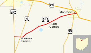
State Route 547 is an east–west state highway in north central Ohio, a U.S. state. The highway's western terminus is at SR 269 approximately four and a half miles (7.2 km) south of Bellevue. The eastern terminus of SR 547 is at the concurrency of U.S. Route 20 (US 20) and SR 18 in downtown Monroeville.

References

Route map: Google

KML file (edithelp)
KML is from Wikidata
  1. 1 2 "DESTAPE - Delaware County" (PDF). Ohio Department of Transportation. June 24, 2015. Retrieved November 17, 2015.
  2. Ohio Department of Transportation. "Technical Services Straight Line Diagrams - SR 521, Delaware County" (PDF). Retrieved 2013-07-11.
  3. Ohio Department of Transportation. "Technical Services Straight Line Diagram - US 36, Delaware County" (PDF). Retrieved 2013-07-11.
  4. Google (July 11, 2013). "Unsigned portion of SR 521" (Map). Google Maps . Google. Retrieved July 11, 2013.
  5. Google (November 17, 2015). "Overview Map of State Route 521" (Map). Google Maps . Google. Retrieved November 17, 2015.
  6. National Highway System: Columbus, OH (PDF) (Map). Federal Highway Administration. March 25, 2015. Retrieved November 17, 2015.
  7. Ohio State Map (Map). Ohio Department of Transportation. 1936.
  8. Ohio State Map (Map). Ohio Department of Transportation. 1937.