Sunbury, Ohio

Last updated

Sunbury, Ohio
Sunbury Admin Building 1.jpg
Sunbury Administration Building
Nickname: 
Memorial Town
OHMap-doton-Sunbury.png
Location of Sunbury, Ohio
Map of Delaware County Ohio Highlighting Sunbury Village.png
Location of Sunbury in Delaware County
Coordinates: 40°14′54″N82°52′50″W / 40.24833°N 82.88056°W / 40.24833; -82.88056
Country United States
State Ohio
County Delaware
Area
[1]
  Total4.83 sq mi (12.52 km2)
  Land4.81 sq mi (12.47 km2)
  Water0.02 sq mi (0.05 km2)
Elevation
[2]
948 ft (289 m)
Population
 (2020)
  Total6,614
  Density1,373.91/sq mi (530.45/km2)
Time zone UTC-5 (Eastern (EST))
  Summer (DST) UTC-4 (EDT)
ZIP code
43074
Area code(s) 740, 220
FIPS code 39-75602 [3]
GNIS feature ID1086057 [2]
Website sunburyvillage.com

Sunbury is a city in Delaware County, Ohio, United States. The population was 6,614 at the 2020 census. Sunbury went from being a village to a city on October 22, 2021. [4]

Contents

Geography

According to the United States Census Bureau, the city has a total area of 3.30 square miles (8.55 km2), of which 3.28 square miles (8.50 km2) are land and 0.02 square miles (0.05 km2) are water. [5]

Sunbury neighbors Galena, Ohio to the south, with which it shares a school district and has provided services such as police. Sunbury is east of Delaware, Ohio (not to be confused with Delaware County, where they are both located).

Demographics

Historical population
CensusPop.Note
1850 337
1870 236
1880 34044.1%
1890 47539.7%
1900 464−2.3%
1910 4854.5%
1920 82770.5%
1930 784−5.2%
1940 8467.9%
1950 93610.6%
1960 1,36045.3%
1970 2,51284.7%
1980 2,101−16.4%
1990 2,046−2.6%
2000 2,63028.5%
2010 4,38966.9%
2020 6,61450.7%
Source: [6]

[7]

2010 census

As of the census [8] of 2010, there were 4,389 people, 1,671 households, and 1,211 families living in the city. The population density was 1,338.1 inhabitants per square mile (516.6/km2). There were 1,774 housing units at an average density of 540.9 per square mile (208.8/km2). The racial makeup of the city was 95.2% White, 1.1% African American, 0.2% Native American, 1.1% Asian, 0.1% Pacific Islander, 0.8% from other races, and 1.5% from two or more races. Hispanic or Latino of any race were 1.7% of the population.

There were 1,671 households, of which 42.5% had children under the age of 18 living with them, 54.3% were married couples living together, 13.9% had a female householder with no husband present, 4.2% had a male householder with no wife present, and 27.5% were non-families. 23.1% of all households were made up of individuals, and 8.9% had someone living alone who was 65 years of age or older. The average household size was 2.62 and the average family size was 3.11.

The median age in the city was 33.6 years. 29.8% of residents were under the age of 18; 6.9% were between the ages of 18 and 24; 30.3% were from 25 to 44; 21.7% were from 45 to 64; and 11.4% were 65 years of age or older. The gender makeup of the city was 47.4% male and 52.6% female.

2000 census

As of the census [3] of 2000, there were 2,630 people, 1,016 households, and 771 families living in the city. The population density was 1,035.0 inhabitants per square mile (399.6/km2). There were 1,057 housing units at an average density of 416.0 per square mile (160.6/km2). The racial makeup of the city was 97.83% White, 0.38% African American, 0.38% Native American, 0.23% Asian, 0.04% Pacific Islander, 0.23% from other races, and 0.91% from two or more races. Hispanic or Latino of any race were 1.10% of the population. As of the 2010 census, the population had increased to 4,389.

There were 1,016 households, out of which 37.1% had children under the age of 18 living with them, 57.7% were married couples living together, 14.2% had a female householder with no husband present, and 24.1% were non-families. 20.8% of all households were made up of individuals, and 9.9% had someone living alone who was 65 years of age or older. The average household size was 2.56 and the average family size was 2.98.

26.6% of the population was under the age of 18, 7.2% from 18 to 24, 30.8% from 25 to 44, 22.3% from 45 to 64, and 13.1% who were 65 years of age or older. The median age was 36 years. For every 100 females there were 88.3 males. For every 100 females age 18 and over, there were 87.1 males.

The median income for a household in the city was $46,477, and the median income for a family was $50,750. Males had a median income of $38,281 versus $28,210 for females. The per capita income for the city was $18,861. About 4.1% of families and 4.7% of the population were below the poverty line, including 4.9% of those under age 18 and 5.0% of those age 65 or over.

Big Walnut School District Administrative Office Big Walnut School District Administrative Office HQ 1.jpg
Big Walnut School District Administrative Office

Education

Sunbury is home to the Big Walnut Local School District. The district also serves students in the neighboring town of Galena, Ohio.

Public services

Emergency medical services are provided by the Delaware County EMS and Station 2. Police services are provided by the Sunbury Police Department.

Notable people

Billy Southworth - American outfielder and manager in Major League Baseball (MLB)

Related Research Articles

<span class="mw-page-title-main">Hancock County, Ohio</span> County in Ohio, United States

Hancock County is a county located in the U.S. state of Ohio. As of the 2020 census, the population was 74,920. Its county seat and largest city is Findlay. The county was created in 1820 and later organized in 1828. It was named for John Hancock, the first signer of the Declaration of Independence.

<span class="mw-page-title-main">Basehor, Kansas</span> City in Kansas, United States

Basehor is a city in Leavenworth County, Kansas, United States which is included statistically in the Kansas City metropolitan area. As of the 2020 census, the population of the city was 6,896.

<span class="mw-page-title-main">Trenton, Ohio</span> City in Ohio, United States

Trenton is a city in northeastern Butler County, Ohio, United States, west of Middletown. The population was 13,021 at the 2020 census. It is part of the Cincinnati metropolitan area.

<span class="mw-page-title-main">Ashley, Ohio</span> Village in Ohio, United States

Ashley is a village in Delaware County, Ohio, United States. The population was 1,198 at the 2020 census.

<span class="mw-page-title-main">Galena, Ohio</span> Village in Ohio, United States

Galena is a village in Delaware County, Ohio, United States. The population was 924 at the 2020 United States Census.

<span class="mw-page-title-main">Ostrander, Ohio</span> Village in Ohio, United States

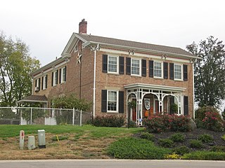
Ostrander is a village in Delaware County, Ohio, United States. The population was 1,094 at the 2020 census.

<span class="mw-page-title-main">Shawnee Hills, Delaware County, Ohio</span> Village in Ohio, United States

Shawnee Hills is a village in Delaware County, Ohio, United States. The population was 835 at the 2020 census. It is a part of the Columbus, Ohio Metropolitan Statistical Area.

<span class="mw-page-title-main">Lockland, Ohio</span> Village in Ohio, United States

Lockland is a village in Hamilton County, Ohio, United States. The population was 3,514 at the 2020 United States Census. Lockland is located in southwest Ohio, north of Cincinnati.

<span class="mw-page-title-main">Springdale, Ohio</span> City in Ohio, United States

Springdale is a city in Hamilton County, Ohio, United States. It is a suburb of Cincinnati. The population was 11,007 at the 2020 census.

<span class="mw-page-title-main">Granville South, Ohio</span> Census-designated place in Ohio, United States

Granville South is a census-designated place (CDP) in Licking County, Ohio, United States. The population was 1,420 at the 2020 census.

<span class="mw-page-title-main">Hanover, Ohio</span> Village in Ohio, United States

Hanover is a village in Licking County, Ohio, United States. The population was 1,270 at the 2020 census. The village lies along Ohio State Route 16.

<span class="mw-page-title-main">Whitehouse, Ohio</span> Village in Ohio, United States

Whitehouse is a village within the Toledo Metropolitan Area in Lucas County, Ohio, United States. The population was 4,990 at the 2020 census.

<span class="mw-page-title-main">Riverside, Ohio</span> City in Ohio, United States

Riverside is a city in Montgomery County, Ohio, United States. The population was 24,474 at the 2020 census. A suburb of Dayton, it is part of the Dayton metropolitan area.

<span class="mw-page-title-main">Cortland, Ohio</span> City in Ohio, United States

Cortland is a city in central Trumbull County, Ohio, United States. It lies on the eastern shore of Mosquito Creek Lake, 19 miles (31 km) north of Youngstown. The population was 7,105 at the 2020 census. It is part of the Youngstown–Warren metropolitan area.

<span class="mw-page-title-main">Newcomerstown, Ohio</span> Village in Ohio, United States

Newcomerstown is a village in Tuscarawas County, Ohio, United States, 85 miles (137 km) east-northeast of Columbus. The population was 3,702 at the 2020 census.

<span class="mw-page-title-main">West Unity, Ohio</span> Village in Ohio, United States

West Unity is a village in Williams County, Ohio, United States. The population was 1,763 at the 2020 census.

<span class="mw-page-title-main">Foster Township, Schuylkill County, Pennsylvania</span> Township in Pennsylvania, United States

Foster Township is a township in Schuylkill County, Pennsylvania, United States. The population was 242 at the 2020 census.

<span class="mw-page-title-main">McMechen, West Virginia</span> City in West Virginia

McMechen is a city in Marshall County, West Virginia, United States, situated along the Ohio River. It is part of the Wheeling, West Virginia Metropolitan Statistical Area. The population was 1,714 at the 2020 census.

<span class="mw-page-title-main">Rittman, Ohio</span> City in Ohio, United States

Rittman is a city in Medina and Wayne counties in the U.S. state of Ohio. All but a small portion of the city is in Wayne County, within commuting distance of Akron, Canton and Cleveland. The population was 6,131 at the 2020 census.

<span class="mw-page-title-main">Taylor Creek, Ohio</span> Census-designated place in Ohio, United States

Taylor Creek is a census-designated place (CDP) in Colerain Township, Hamilton County, Ohio, United States. The population was 4,056 at the 2020 census.

References

  1. "ArcGIS REST Services Directory". United States Census Bureau. Retrieved September 20, 2022.
  2. 1 2 U.S. Geological Survey Geographic Names Information System: Sunbury, Ohio
  3. 1 2 "U.S. Census website". United States Census Bureau . Retrieved January 31, 2008.
  4. "It's official: City of Sunbury - Delaware Gazette". November 12, 2021.
  5. "US Gazetteer files 2010". United States Census Bureau. Archived from the original on January 25, 2012. Retrieved January 6, 2013.
  6. "Census of Population and Housing". United States Census Bureau . Retrieved December 31, 2013.
  7. https://www.census.gov/quickfacts/fact/table/sunburyvillageohio,OH/PST045219 [ dead link ]
  8. "U.S. Census website". United States Census Bureau . Retrieved January 6, 2013.