Shawnee Hills, Delaware County, Ohio

Last updated

Shawnee Hills, Ohio
Shawnee Hills village hall.jpg
Village Hall
OHMap-doton-Shawnee Hills Delaware County.png
Location of Shawnee Hills, Delaware County, Ohio
Map of Delaware County Ohio Highlighting Shawnee Hills Village.png
Location of Shawnee Hills in Delaware County
Coordinates: 40°09′36″N83°08′08″W / 40.16000°N 83.13556°W / 40.16000; -83.13556
Country United States
State Ohio
County Delaware
Township Concord
Area
[1]
  Total0.45 sq mi (1.15 km2)
  Land0.45 sq mi (1.15 km2)
  Water0.00 sq mi (0.00 km2)
Elevation
[2]
896 ft (273 m)
Population
 (2020)
  Total835
  Density1,876.40/sq mi (725.06/km2)
Time zone UTC-5 (Eastern (EST))
  Summer (DST) UTC-4 (EDT)
ZIP code
43065
Area code 614
FIPS code 39-71976 [3]
GNIS feature ID2399793 [2]
Website www.shawneehillsoh.org

Shawnee Hills is a village in Delaware County, Ohio, United States. The population was 835 at the 2020 census. It is a part of the Columbus, Ohio Metropolitan Statistical Area.

Contents

Geography

According to the United States Census Bureau, the village has a total area of 0.44 square miles (1.14 km2), all land. [4]

Demographics

Historical population
CensusPop.Note
1950 338
1960 39416.6%
1970 4288.6%
1980 4300.5%
1990 423−1.6%
2000 419−0.9%
2010 68162.5%
2020 83522.6%
U.S. Decennial Census [5]

2010 census

As of the census [6] of 2010, there were 681 people, 268 households, and 188 families living in the village. The population density was 1,547.7 inhabitants per square mile (597.6/km2). There were 295 housing units at an average density of 670.5 per square mile (258.9/km2). The racial makeup of the village was 92.5% White, 0.1% Native American, 3.2% Asian, 0.3% from other races, 2.5% African American, and 1.3% from two or more races. Hispanic or Latino of any race were 1.9% of the population.

There were 268 households, of which 34.0% had children under the age of 18 living with them, 57.8% were married couples living together, 6.0% had a female householder with no husband present, 6.3% had a male householder with no wife present, and 29.9% were non-families. 22.4% of all households were made up of individuals, and 6.3% had someone living alone who was 65 years of age or older. The average household size was 2.54 and the average family size was 2.97.

The median age in the village was 40.6 years. 24.1% of residents were under the age of 18; 4.6% were between the ages of 18 and 24; 28.4% were from 25 to 44; 33.6% were from 45 to 64; and 9.1% were 65 years of age or older. The gender makeup of the village was 52.1% male and 47.9% female.

2000 census

As of the census [3] of 2000, there were 419 people, 181 households, and 116 families living in the village. The population density was 1,081.3 inhabitants per square mile (417.5/km2). There were 199 housing units at an average density of 513.5 per square mile (198.3/km2). The racial makeup of the village was 95.23% White, 2.15% African American, 1.43% Asian, and 1.19% from two or more races. Hispanic or Latino of any race were 1.91% of the population.

There were 181 households, out of which 26.0% had children under the age of 18 living with them, 52.5% were married couples living together, 7.2% had a female householder with no husband present, and 35.4% were non-families. 24.3% of all households were made up of individuals, and 6.1% had someone living alone who was 65 years of age or older. The average household size was 2.31 and the average family size was 2.73.

In the village, the population was spread out, with 21.5% under the age of 18, 4.5% from 18 to 24, 34.8% from 25 to 44, 28.2% from 45 to 64, and 11.0% who were 65 years of age or older. The median age was 40 years. For every 100 females there were 91.3 males. For every 100 females age 18 and over, there were 95.8 males.

The median income for a household in the village was $52,222, and the median income for a family was $70,179. Males had a median income of $51,250 versus $32,059 for females. The per capita income for the village was $25,266. About 5.4% of families and 7.8% of the population were below the poverty line, including 12.3% of those under age 18 and 5.7% of those age 65 or over.

Related Research Articles

<span class="mw-page-title-main">Chillicothe, Iowa</span> City in Iowa, United States

Chillicothe is a city in Wapello County, Iowa, United States. The population was 76 at the 2020 census.

<span class="mw-page-title-main">Fairway, Kansas</span> City in Kansas, United States

Fairway is a city in Johnson County, Kansas, United States. It is included in the Kansas City metropolitan area census designation and the Shawnee Mission postal services designation. As of the 2020 United States census, the city population was 4,170.

<span class="mw-page-title-main">Merriam, Kansas</span> City in Kansas, United States

Merriam is a city in Johnson County, Kansas, United States, and part of the Kansas City Metropolitan Area. As of the 2020 census, the population of the city was 11,098. Merriam is included in the Shawnee Mission postal designation. It is also the headquarters of Seaboard Corporation.

<span class="mw-page-title-main">Mission, Kansas</span> City in Kansas, United States

Mission is a city in Johnson County, Kansas, United States, and part of the Kansas City Metropolitan Area. As of the 2020 census, the population of the city was 9,954.

<span class="mw-page-title-main">Prairie Village, Kansas</span> City in Kansas, United States

Prairie Village is a city in Johnson County, Kansas, United States, and located within the Kansas City Metropolitan Area. As of the 2020 census, the population of the city was 22,957.

<span class="mw-page-title-main">Westwood, Kansas</span> City in Kansas, United States

Westwood is a city in northeast Johnson County, Kansas, United States. As of the 2020 census, the population of the city was 1,750. It is the second most densely populated city in the Kansas City Metropolitan Area.

<span class="mw-page-title-main">Rossville, Kansas</span> City in Shawnee County, Kansas

Rossville is a city in Shawnee County, Kansas, United States. As of the 2020 census, the population of the city was 1,105.

<span class="mw-page-title-main">Fort Shawnee, Ohio</span> CDP in Ohio, United States

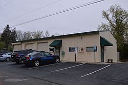
Fort Shawnee is census-designated place (CDP) in Allen County, Ohio, United States. The population was 6,263 at the 2020 census. It is included in the Lima, Ohio Metropolitan Statistical Area. Fort Shawnee is adjacent to the city of Lima and the village of Cridersville in Auglaize County. In 2012, village residents voted to disincorporate the village. According to the United States Census Bureau, the village had a total area of 7.25 square miles (18.78 km2), of which 7.21 square miles (18.67 km2) is land and 0.04 square miles (0.10 km2) is water.

<span class="mw-page-title-main">Cridersville, Ohio</span> Village in Ohio, United States

Cridersville is a village in Auglaize County, Ohio, United States. The population was 1,791 at the 2020 census. It is included in the Wapakoneta, Ohio Micropolitan Statistical Area.

<span class="mw-page-title-main">Jamestown, Ohio</span> Village in Ohio, United States

Jamestown is a village in Greene County, Ohio, United States. The population was 2,052 at the 2020 census.

<span class="mw-page-title-main">Shawnee Hills, Greene County, Ohio</span> Census-designated place in Ohio, United States

Shawnee Hills is a census-designated place (CDP) in Greene County, Ohio, United States. Shawnee Hills consists of a planned community centered on the 250-acre (1.0 km2) Shawnee Lake. The population was 2,230 at the 2020 census. It is part of the Dayton Metropolitan Statistical Area, and should not be confused with the incorporated village of Shawnee Hills in Delaware County.

<span class="mw-page-title-main">Terrace Park, Ohio</span> Village in Ohio, United States

Terrace Park is a village in Hamilton County, Ohio, and a suburb of Greater Cincinnati. The population was 2,355 at the 2020 census.

<span class="mw-page-title-main">Florida, Ohio</span> Village in Ohio, United States

Florida is a village in Henry County, Ohio, United States, along the Maumee River. The population was 215 at the 2020 census.

<span class="mw-page-title-main">Whitehouse, Ohio</span> Village in Ohio, United States

Whitehouse is a village within the Toledo Metropolitan Area in Lucas County, Ohio, United States. The population was 4,990 at the 2020 census.

<span class="mw-page-title-main">Shawnee, Perry County, Ohio</span> Village in Ohio, United States

Shawnee is a village in Perry County, Ohio, United States. The population was 505 at the 2020 census. It is 9 miles (14 km) south of the county seat of New Lexington.

<span class="mw-page-title-main">Camden, Ohio</span> Village in Ohio, United States

Camden is a village in Preble County, Ohio, United States. The population was 1,989 at the 2020 census.

<span class="mw-page-title-main">West Elkton, Ohio</span> Village in Ohio, United States

West Elkton is a village in Preble County, Ohio, United States. The population was 164 at the 2020 census. It is part of the Dayton Metropolitan Statistical Area.

<span class="mw-page-title-main">Verona, Ohio</span> Village in Ohio, United States

Verona is a village in Montgomery and Preble counties in the U.S. state of Ohio. The population was 403 at the 2020 census. It is part of the Dayton Metropolitan Statistical Area.

<span class="mw-page-title-main">Lowell, Wisconsin</span> Village in Wisconsin, United States

Lowell is a village in Dodge County, Wisconsin, United States, along the Beaver Dam River. The population was 340 at the 2010 census. The village is located within the Town of Lowell.

<span class="mw-page-title-main">Shawnee, Hamilton County, Ohio</span> Census-designated place in Ohio, United States

Shawnee is a census-designated place (CDP) in Miami Township, Hamilton County, Ohio, United States, 21 miles (34 km) west of downtown Cincinnati. The population of Shawnee was 747 at the 2020 census.

References

  1. "ArcGIS REST Services Directory". United States Census Bureau. Retrieved September 20, 2022.
  2. 1 2 U.S. Geological Survey Geographic Names Information System: Shawnee Hills, Delaware County, Ohio
  3. 1 2 "U.S. Census website". United States Census Bureau . Retrieved January 31, 2008.
  4. "US Gazetteer files 2010". United States Census Bureau. Archived from the original on January 25, 2012. Retrieved January 6, 2013.
  5. "Census of Population and Housing". Census.gov. Retrieved June 4, 2015.
  6. "U.S. Census website". United States Census Bureau . Retrieved January 6, 2013.