Old Jefferson, Louisiana

Last updated

For Old Jefferson in Jefferson Parish, Louisiana, see: Jefferson, Louisiana
Old Jefferson
BR Old Jefferson.JPG
East Baton Rouge Parish Louisiana incorporated and unincorporated areas Old Jefferson highlighted.svg
Location in East Baton Rouge Parish and the state of Louisiana.
Coordinates: 30°22′53″N91°00′37″W / 30.38139°N 91.01028°W / 30.38139; -91.01028
CountryUnited States
StateLouisiana
Parish East Baton Rouge
Area
[1]
  Total3.52 sq mi (9.12 km2)
  Land3.52 sq mi (9.12 km2)
  Water0.00 sq mi (0.00 km2)
Elevation
30 ft (9 m)
Population
 (2020)
  Total7,339
  Density2,085.54/sq mi (805.12/km2)
Time zone UTC-6 (CST)
  Summer (DST) UTC-5 (CDT)
ZIP code
70817 [2]
Area code 225
FIPS code 22-57705

Old Jefferson is a census-designated place (CDP) in East Baton Rouge Parish, Louisiana, United States. The population was 6,980 at the 2010 census, up from 5,631 in 2000. It is part of the Baton Rouge Metropolitan Statistical Area.

Contents

Geography

Old Jefferson is located at 30°22′53″N91°0′37″W / 30.38139°N 91.01028°W / 30.38139; -91.01028 (30.381292, -91.010376). [3]

According to the United States Census Bureau, the CDP has a total area of 3.5 square miles (9.1 km2), all land.

Demographics

Historical population
CensusPop.Note
1990 4,531
2000 5,63124.3%
2010 6,98024.0%
2020 7,3395.1%
source: [4]
Old Jefferson racial composition as of 2020 [5]
RaceNumberPercentage
White (non-Hispanic)4,72764.41%
Black or African American (non-Hispanic)1,46920.02%
Native American 160.22%
Asian 2383.24%
Pacific Islander 20.03%
Other/Mixed 2974.05%
Hispanic or Latino 5908.04%

As of the 2020 United States census, there were 7,339 people, 2,772 households, and 2,021 families residing in the CDP.

As of the census [6] of 2000, there were 5,631 people, 2,044 households, and 1,582 families residing in the CDP. The population density was 1,594.7 inhabitants per square mile (615.7/km2). There were 2,110 housing units at an average density of 597.6 per square mile (230.7/km2). The racial makeup of the CDP was 90.37% White, 5.68% African American, 0.39% Native American, 1.90% Asian, 0.07% Pacific Islander, 0.44% from other races, and 1.14% from two or more races. Hispanic or Latino of any race were 1.56% of the population.

There were 2,044 households, out of which 45.5% had children under the age of 18 living with them, 62.9% were married couples living together, 10.4% had a female householder with no husband present, and 22.6% were non-families. 17.9% of all households were made up of individuals, and 3.1% had someone living alone who was 65 years of age or older. The average household size was 2.75 and the average family size was 3.15.

In the CDP, the population was spread out, with 29.4% under the age of 18, 8.1% from 18 to 24, 36.8% from 25 to 44, 21.0% from 45 to 64, and 4.6% who were 65 years of age or older. The median age was 32 years. For every 100 females, there were 98.4 males. For every 100 females age 18 and over, there were 93.8 males.

The median income for a household in the CDP was $52,220, and the median income for a family was $59,778. Males had a median income of $41,164 versus $27,044 for females. The per capita income for the CDP was $21,410. About 2.3% of families and 3.7% of the population were below the poverty line, including 4.8% of those under age 18 and none of those age 65 or over.

Education

Public schools

Old Jefferson is served by East Baton Rouge Parish Public Schools. [7]

Zoned schools include:

In previous eras Parkview Elementary School served the northern half of Old Jefferson, [11] while Jefferson Terrace Elementary School served the southern section of Old Jefferson. [12]

Private schools

Private schools in the area include:

The district provides transportation to these two private Catholic schools.[ citation needed ]

Related Research Articles

<span class="mw-page-title-main">West Feliciana Parish, Louisiana</span> Parish in Louisiana, United States

West Feliciana Parish is a civil parish located in the U.S. state of Louisiana. At the 2020 census, the population was 15,310. The parish seat is St. Francisville. The parish was established in 1824.

<span class="mw-page-title-main">Vermilion Parish, Louisiana</span> Parish in Louisiana, United States

Vermilion Parish is a parish located in the U.S. state of Louisiana, created in 1844. The parish seat is Abbeville. Vermilion Parish is part of the Lafayette metropolitan statistical area, and located in southern Acadiana. At the 2020 U.S. census, the population was 57,359.

<span class="mw-page-title-main">East Feliciana Parish, Louisiana</span> Parish in Louisiana, United States

East Feliciana Parish is a parish located in the U.S. state of Louisiana. At the 2020 census, the population was 19,531. The parish seat is Clinton.

<span class="mw-page-title-main">East Baton Rouge Parish, Louisiana</span> Parish in Louisiana, United States

East Baton Rouge Parish is the most populous parish in the U.S. state of Louisiana. Its population was 456,781 at the 2020 census. The parish seat is Baton Rouge, Louisiana's state capital. East Baton Rouge Parish is located within the Greater Baton Rouge area.

<span class="mw-page-title-main">Brownfields, Louisiana</span> Census-designated place in Louisiana, United States

Brownfields is an unincorporated area and census-designated place (CDP) in East Baton Rouge Parish, Louisiana, United States. The population was 5,401 at the 2010 census. It is part of the Baton Rouge Metropolitan Statistical Area.

<span class="mw-page-title-main">Gardere, Louisiana</span> Census-designated place in Louisiana, United States

Gardere is an unincorporated area and census-designated place (CDP) in East Baton Rouge Parish, Louisiana, United States. The area is also known as Riverland. The population was 10,580 at the 2010 census, up from 8,992 in 2000. It is part of the Baton Rouge Metropolitan Statistical Area.

<span class="mw-page-title-main">Inniswold, Louisiana</span> Census-designated place in Louisiana, United States

Inniswold is an unincorporated area and census-designated place (CDP) in East Baton Rouge Parish, Louisiana, United States. The population was 6,180 at the 2010 census, up from 4,944 in 2000. In 2020, its population was 5,987. It is part of the Baton Rouge metropolitan statistical area.

<span class="mw-page-title-main">Merrydale, Louisiana</span> Census-designated place in Louisiana, United States

Merrydale is an unincorporated area and census-designated place (CDP) in East Baton Rouge Parish, Louisiana, United States. The population was 9,772 at the 2010 census, down from 10,427 in 2000. It is part of the Baton Rouge Metropolitan Statistical Area.

<span class="mw-page-title-main">Monticello, Louisiana</span> Census-designated place in Louisiana, United States

Monticello is a census-designated place (CDP) in East Baton Rouge Parish, Louisiana, United States. The population was 5,172 at the 2010 census, up from 4,763 in 2000. It is part of the Baton Rouge Metropolitan Statistical Area.

<span class="mw-page-title-main">Oak Hills Place, Louisiana</span> Census-designated place in Louisiana, United States

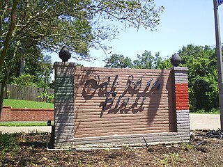
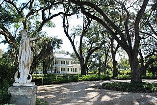
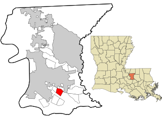
Oak Hills Place is a census-designated place (CDP) in East Baton Rouge Parish, Louisiana, United States. The population was 8,195 at the 2010 census. It is part of the Baton Rouge Metropolitan Statistical Area, and one of the most affluent suburbs of Baton Rouge.

<span class="mw-page-title-main">Shenandoah, Louisiana</span> Census-designated place in Louisiana, United States

Shenandoah is an unincorporated area and census-designated place (CDP) in East Baton Rouge Parish, Louisiana, United States. It is part of the Baton Rouge Metropolitan Statistical Area. The population was 18,399 at the 2010 census, up from 17,070 in 2000. Shenandoah consists of a number of residential subdivisions, including Shenandoah Estates, Shenandoah Park, White Oak Landing, White Oak Estates, The Woods and The Lake at White Oak.

<span class="mw-page-title-main">Village St. George, Louisiana</span> Census-designated place in Louisiana, United States

Village St. George is a census-designated place (CDP) in East Baton Rouge Parish, Louisiana, United States. The population was 7,104 at the 2010 census. It is part of the Baton Rouge Metropolitan Statistical Area.

<span class="mw-page-title-main">Westminster, Louisiana</span> Census-designated place in Louisiana, United States

Westminster is a census-designated place (CDP) in East Baton Rouge Parish, Louisiana, United States. The population was 3,008 at the 2010 census, up from 2,515 in 2000. It is part of the Baton Rouge Metropolitan Statistical Area.

<span class="mw-page-title-main">Zachary, Louisiana</span> City in Louisiana, United States

Zachary is a city in East Baton Rouge Parish, Louisiana, United States. It lies 16 miles (26 km) north of the city of Baton Rouge, and had a population of 14,960 at the 2010 census, up from 11,275 in 2000. At the 2020 census, Zachary's population increased to 19,316.

<span class="mw-page-title-main">Harvey, Louisiana</span> Census-designated place in Louisiana, United States

Harvey is a census-designated place (CDP) in Jefferson Parish, Louisiana, United States. Harvey is on the south side of the Mississippi River, within the New Orleans–Metairie–Kenner metropolitan statistical area. The majority-minority population was 20,348 at the 2010 census, down from 22,226 at the 2000 census. The 2020 census determined 22,236 people lived in the CDP.

<span class="mw-page-title-main">Jefferson, Louisiana</span> Census-designated place in Louisiana, United States

Jefferson is a census-designated place (CDP) in Jefferson Parish, Louisiana, United States, on the north side of the Mississippi River. Jefferson is part of the New Orleans–Metairie–Kenner metropolitan statistical area. The population was 11,193 at the 2010 census, and 10,533 in 2020. It is often known by locals as "Old Jefferson", but should not be confused with Old Jefferson in East Baton Rouge Parish, Louisiana.

<span class="mw-page-title-main">Terrytown, Louisiana</span> Census-designated place in Louisiana, United States

Terrytown is an unincorporated community and census-designated place (CDP) in Jefferson Parish, Louisiana, United States. It is on the "Westbank" of the Mississippi River. It is a suburb within the New Orleans–Metairie–Kenner metropolitan statistical area. The population was 23,319 at the 2010 census, and 25,278 in 2020.

Boothville-Venice is a former census-designated place (CDP) in Plaquemines Parish, Louisiana, United States, which includes the unincorporated communities of Boothville, Venice, and Orchard. The population was 2,220 at the 2000 census. For the 2010 census, Boothville-Venice was split into the CDPs of Boothville and Venice.

<span class="mw-page-title-main">Woodlawn High School (East Baton Rouge Parish, Louisiana)</span> Public school

Woodlawn High School is a public high school in Old Jefferson, a census-designated place in unincorporated East Baton Rouge Parish, Louisiana, United States, in the Baton Rouge metropolitan area. It is operated by the East Baton Rouge Parish School District.

Tara High School is one of several high schools in the East Baton Rouge Parish Public Schools District in Baton Rouge, Louisiana. It is located in the Tara Neighborhood of Baton Rouge. Tara High School is located at 9002 Whitehall Avenue, Baton Rouge, LA 70806. The school opened during the 1970–71 school year.

References

  1. "2020 U.S. Gazetteer Files". United States Census Bureau. Retrieved March 20, 2022.
  2. "Old Jefferson LA ZIP Code". zipdatamaps.com. 2023. Retrieved June 16, 2023.
  3. "US Gazetteer files: 2010, 2000, and 1990". United States Census Bureau. February 12, 2011. Retrieved April 23, 2011.
  4. "CENSUS OF POPULATION AND HOUSING (1790-2000)". U.S. Census Bureau . Retrieved July 17, 2010.
  5. "Explore Census Data". data.census.gov. Retrieved December 28, 2021.
  6. "U.S. Census website". United States Census Bureau . Retrieved January 31, 2008.
  7. "2010 CENSUS - CENSUS BLOCK MAP: Old Jefferson CDP, LA." U.S. Census Bureau. Retrieved on January 7, 2017.
  8. "Elemementary-School-Boundary-Descriptions-15-16.pdf Archived 2017-01-06 at the Wayback Machine ." East Baton Rouge Parish Public Schools. Retrieved on January 7, 2017. Woodlawn is on page 41/41: "8160 Antioch Road, Baton Rouge". Shenadoah is on page 32/41.
  9. "Middle-School-Boundary-Descriptions-15-16.pdf Archived 2017-01-06 at the Wayback Machine ." East Baton Rouge Parish Public Schools. Retrieved on January 6, 2017. Woodlawn Middle is on p. 14/14.
  10. "High-School-Boundary-Descriptions-15-16.pdf Archived 2016-04-18 at the Wayback Machine ." East Baton Rouge Parish Public Schools. Retrieved on January 7, 2017. Woodlawn is on p. 10/10.
  11. "mapselemm-z.pdf." East Baton Rouge Parish Public Schools. April 26, 2005. Retrieved on January 6, 2017. Parkview is on page 8/23.
  12. "mapselema-l.pdf." East Baton Rouge Parish Public Schools. April 26, 2005. Retrieved on January 7, 2017. p. 23/26 has the map for Jefferson Terrace Elementary School.
  13. Home. Most Blessed Sacrament Catholic School. Retrieved on January 7, 2017. "8033 Baringer Road Baton Rouge, LA 70817"