Baker, Louisiana

Last updated

Baker, Louisiana
City of Baker
East Baton Rouge Parish Louisiana Incorporated and Unincorporated areas Baker Highlighted.svg
Location of Baker in East Baton Rouge Parish, Louisiana
USA Louisiana location map.svg
Red pog.svg
Baker
Location of Louisiana in the United States
Usa edcp location map.svg
Red pog.svg
Baker
Baker (the United States)
Coordinates: 30°35′08″N91°09′26″W / 30.58556°N 91.15722°W / 30.58556; -91.15722
CountryFlag of the United States.svg  United States
StateFlag of Louisiana.svg  Louisiana
Parish East Baton Rouge
Government
  MayorDarnell Waites (D) (elected April 10, 2016)
Area
[1]
  Total8.40 sq mi (21.75 km2)
  Land8.40 sq mi (21.75 km2)
  Water0.00 sq mi (0.00 km2)
Population
 (2020)
  Total12,455
  Density1,482.91/sq mi (572.53/km2)
Time zone UTC-6 (CST)
  Summer (DST) UTC-5 (CDT)
ZIP code
70714 [2]
Area code 225
FIPS code 22-03985
Website cityofbakerla.us

Baker is a city in the U.S. state of Louisiana, in East Baton Rouge Parish. It is part of the Baton Rouge metropolitan statistical area, and had a population of 12,455 at the 2020 census, [3] down from 13,895 at the 2010 U.S. census. [4]

Contents

History

Baker was named in 1888 for an early settler. [5]

Geography

Baker is located north of the center of East Baton Rouge Parish at 30°35′8″N91°9′26″W / 30.58556°N 91.15722°W / 30.58556; -91.15722 (30.585637, -91.157096). [6] It is bordered to the north by Zachary and to the south by Baton Rouge. According to the United States Census Bureau, Baker has a total area of 8.3 square miles (21.5 km2), all land. [4]

Louisiana Highway 19 runs through the center of Baker, leading north 4 miles (6 km) to the center of Zachary and south 5 miles (8 km) to U.S. Route 61 in the northern part of Baton Rouge. Downtown Baton Rouge is 11 miles (18 km) south of Baker. Louisiana Highway 67 passes through the eastern part of Baker, leading north 22 miles (35 km) to Clinton and south 9 miles (14 km) into the center of Baton Rouge.

Demographics

Historical population
CensusPop.Note
1950 762
1960 4,823532.9%
1970 8,28171.7%
1980 12,86555.4%
1990 13,2332.9%
2000 13,7934.2%
2010 13,8950.7%
2020 12,455−10.4%
U.S. Decennial Census [7]
Baker racial composition as of 2020 [8]
RaceNumberPercentage
White (non-Hispanic)1,67213.42%
Black or African American (non-Hispanic)10,21281.99%
Native American 100.08%
Asian 240.19%
Pacific Islander 10.01%
Other/Mixed 2441.96%
Hispanic or Latino 2922.34%

At the 2019 American Community Survey, there were 13,437 people, [9] 4,693 households, and 3,097 families residing in the city. [10] As of 2010, the population density was 1,674.3 people per square mile. [11] In 2019, there were 5,276 housing units. [9] According to the 2020 United States census, there were 12,455 people, 4,693 households, and 3,097 families residing in the city.

The racial and ethnic makeup of the city was 84.6% Black and African American, 13.6% non-Hispanic white, 0.1% American Indian or Alaska Native, 0.3% Asian, 0.4% Native Hawaiian and other Pacific Islander, 0.1% some other race, 0.4% two or more races, and 0.5% Hispanic and Latin American of any race. [9] At the 2000 United States census, [12] the racial makeup of the city was 45.97% White, 52.36% African American, 0.28% Native American, 0.22% Asian, 0.01% Pacific Islander, 0.17% from other races, and 0.99% from two or more races; Hispanic or Latin American people of any race were 0.86% of the population.

Of the 4,693 households in 2019, there were 88 males per 100 females, and the median age was 34.8 years. [9] The average household size was 2.83, [10] and the average family size was 3.63. An estimated 30.2% of households had one or more people under 18 years of age, and 34.7% with one or more people aged 65 and older; 28.8% of householders lived alone. There was an ownership rate of 67.4%, and 32.6% had renter-occupied housing units. The median household income was $53,082 and males had a median income of $40,926 versus $30,872 for females. [13] Approximately 12.9% of the population lived at or below the poverty line.

Baker received an influx of New Orleans residents during the immediate aftermath of Hurricanes Katrina and Rita. Renaissance Village (established by the Federal Emergency Management Agency) was the home to more than 3,000 evacuees, of whom more than 500 were school-age children. The large majority of the residents came from the poorest parts of New Orleans.

Government and infrastructure

The United States Postal Service operates the Baker Post Office. [14]

The Jetson Center for Youth, a former juvenile prison operated by the Louisiana Office of Juvenile Justice, is located near Baker in an unincorporated area. [15]

Baker Buffalo Festival

The Baker Buffalo Festival is held every year on the last full weekend in September. The festival was started in 1993 as a fundraiser for the schools in Baker. The schools and their organizations use the festival to raise money for their activities. The Festival Committee also makes donations to all the schools that participate. The event includes a festival, parade, Queen's pageant, and car show.

Education

Baker residents are zoned to the City of Baker School System. Baker High School is the city's high school.

Unincorporated areas with Baker addresses are within the East Baton Rouge Parish Public Schools.

East Baton Rouge Parish Library operates the Baker Branch, located across from Baker High School. The library opened in Miss Angie Williams' Tea Room on June 19, 1941 and subsequently moved to a school building in 1955, a third building, and then the Baker Masonic Lodge on July 20, 1959. The current library, with 17,900 square feet (1,660 m2) of space, opened in April 2001; it was designed by Cockfield-Jackson Architects. [16]

National Guard

Baker is home to the 926th MAC (mobility augmentation company) which is part of the 769th Engineer Battalion (combat) headquartered in Baton Rouge. These units belong to the 225th Engineer Brigade which is headquartered at Pineville on Louisiana National Guard Training Center Pineville. As of 2011 this unit has been activated for overseas deployment to a combat theater.

Notable people

Twin cities

FlagCityCountry
Flag of Senegal.svg Joal-Fadiouth Senegal

See also

Related Research Articles

<span class="mw-page-title-main">West Baton Rouge Parish, Louisiana</span> Parish in Louisiana, United States

West Baton Rouge Parish is one of the sixty-four parishes in the U.S. state of Louisiana. Established in 1807, its parish seat is Port Allen. With a 2020 census population of 27,199 residents, West Baton Rouge Parish is part of the Baton Rouge metropolitan statistical area.

<span class="mw-page-title-main">East Baton Rouge Parish, Louisiana</span> Parish in Louisiana, United States

East Baton Rouge Parish is the most populous parish in the U.S. state of Louisiana. Its population was 456,781 at the 2020 census. The parish seat is Baton Rouge, Louisiana's state capital. East Baton Rouge Parish is located within the Greater Baton Rouge area.

<span class="mw-page-title-main">Brownfields, Louisiana</span> Census-designated place in Louisiana, United States

Brownfields is an unincorporated area and census-designated place (CDP) in East Baton Rouge Parish, Louisiana, United States. The population was 5,401 at the 2010 census. It is part of the Baton Rouge Metropolitan Statistical Area.

<span class="mw-page-title-main">Gardere, Louisiana</span> Census-designated place in Louisiana, United States

Gardere is an unincorporated area and census-designated place (CDP) in East Baton Rouge Parish, Louisiana, United States. The area is also known as Riverland. The population was 10,580 at the 2010 census, up from 8,992 in 2000. It is part of the Baton Rouge Metropolitan Statistical Area.

<span class="mw-page-title-main">Inniswold, Louisiana</span> Census-designated place in Louisiana, United States

Inniswold is an unincorporated area and census-designated place (CDP) in East Baton Rouge Parish, Louisiana, United States. The population was 6,180 at the 2010 census, up from 4,944 in 2000. In 2020, its population was 5,987. It is part of the Baton Rouge metropolitan statistical area.

<span class="mw-page-title-main">Merrydale, Louisiana</span> Census-designated place in Louisiana, United States

Merrydale is an unincorporated area and census-designated place (CDP) in East Baton Rouge Parish, Louisiana, United States. The population was 9,772 at the 2010 census, down from 10,427 in 2000. It is part of the Baton Rouge Metropolitan Statistical Area.

<span class="mw-page-title-main">Monticello, Louisiana</span> Census-designated place in Louisiana, United States

Monticello is a census-designated place (CDP) in East Baton Rouge Parish, Louisiana, United States. The population was 5,172 at the 2010 census, up from 4,763 in 2000. It is part of the Baton Rouge Metropolitan Statistical Area.

<span class="mw-page-title-main">Oak Hills Place, Louisiana</span> Census-designated place in Louisiana, United States

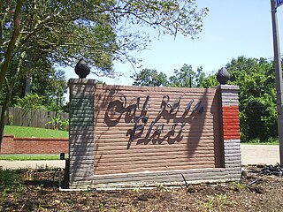
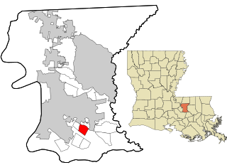
Oak Hills Place is a census-designated place (CDP) in East Baton Rouge Parish, Louisiana, United States. The population was 8,195 at the 2010 census. It is part of the Baton Rouge Metropolitan Statistical Area, and one of the most affluent suburbs of Baton Rouge.

<span class="mw-page-title-main">Old Jefferson, Louisiana</span> Census-designated place in Louisiana, United States

Old Jefferson is a census-designated place (CDP) in East Baton Rouge Parish, Louisiana, United States. The population was 6,980 at the 2010 census, up from 5,631 in 2000. It is part of the Baton Rouge Metropolitan Statistical Area.

<span class="mw-page-title-main">Shenandoah, Louisiana</span> Census-designated place in Louisiana, United States

Shenandoah is an unincorporated area and census-designated place (CDP) in East Baton Rouge Parish, Louisiana, United States. It is part of the Baton Rouge Metropolitan Statistical Area. The population was 18,399 at the 2010 census, up from 17,070 in 2000. Shenandoah consists of a number of residential subdivisions, including Shenandoah Estates, Shenandoah Park, White Oak Landing, White Oak Estates, The Woods and The Lake at White Oak.

<span class="mw-page-title-main">Village St. George, Louisiana</span> Census-designated place in Louisiana, United States

Village St. George is a census-designated place (CDP) in East Baton Rouge Parish, Louisiana, United States. The population was 7,104 at the 2010 census. It is part of the Baton Rouge Metropolitan Statistical Area.

<span class="mw-page-title-main">Westminster, Louisiana</span> Census-designated place in Louisiana, United States

Westminster is a census-designated place (CDP) in East Baton Rouge Parish, Louisiana, United States. The population was 3,008 at the 2010 census, up from 2,515 in 2000. It is part of the Baton Rouge Metropolitan Statistical Area.

<span class="mw-page-title-main">Zachary, Louisiana</span> City in Louisiana, United States

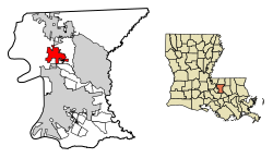
Zachary is a city in East Baton Rouge Parish, Louisiana, United States. It lies 16 miles (26 km) north of the city of Baton Rouge, and had a population of 14,960 at the 2010 census, up from 11,275 in 2000. At the 2020 census, Zachary's population increased to 19,316.

<span class="mw-page-title-main">Norwood, Louisiana</span> Village in Louisiana, United States

Norwood is a village in East Feliciana Parish, Louisiana, United States. The population was 322 at the 2010 census. It is part of the Baton Rouge Metropolitan Statistical Area.

<span class="mw-page-title-main">Slaughter, Louisiana</span> Town in Louisiana, United States

Slaughter is a town in East Feliciana Parish, Louisiana, United States. The population was 997 at the 2010 U.S. census, down from 1,011 at the 2000 U.S. census. At the 2020 population estimates program, the U.S. Census Bureau estimated 882 people lived in the township. Slaughter is part of the Baton Rouge metropolitan statistical area.

<span class="mw-page-title-main">Wilson, Louisiana</span> Village in Louisiana, United States

Wilson is a village in East Feliciana Parish, Louisiana, United States. The population was 595 at the 2010 census, down from 668 in 2000. It is part of the Baton Rouge Metropolitan Statistical Area.

<span class="mw-page-title-main">Grosse Tête, Louisiana</span> Village in Louisiana, United States

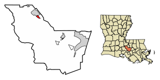
Grosse Tête is a village in Iberville Parish, Louisiana, United States. The population was 647 at the 2010 census, and 731 at the 2019 American Community Survey. The village name is French for "Big Head". Grosse Tête is part of the Baton Rouge metropolitan statistical area.

<span class="mw-page-title-main">St. Gabriel, Louisiana</span> City in Louisiana, United States

St. Gabriel is a city in Iberville Parish, Louisiana, United States. The city of St. Gabriel includes the Carville neighborhood and portions of Sunchine. Part of the Baton Rouge metropolitan statistical area, it had a population of 6,677 at the 2010 U.S. census, and 6,433 at the 2020 census.

<span class="mw-page-title-main">Addis, Louisiana</span> Town in Louisiana, United States

Addis is a town in West Baton Rouge Parish, Louisiana, United States. The population was 3,593 at the 2010 census. It is part of the Baton Rouge Metropolitan Statistical Area.

<span class="mw-page-title-main">Port Allen, Louisiana</span> City in Louisiana, United States

Port Allen is a city in, and the parish seat of, West Baton Rouge Parish, Louisiana, United States. Located on the west bank of the Mississippi River, it is bordered by Interstate 10 and US Highway 190. The population was 4,939 in 2020. It is part of the Baton Rouge metropolitan statistical area.

References

  1. "2020 U.S. Gazetteer Files". United States Census Bureau. Retrieved March 20, 2022.
  2. "Baker LA ZIP Code". zipdatamaps.com. 2023. Retrieved January 26, 2023.
  3. "QuickFacts: Baker city, Louisiana". U.S. Census Bureau. Retrieved August 12, 2021.
  4. 1 2 "Geographic Identifiers: 2010 Demographic Profile Data (G001): Baker city, Louisiana". American Factfinder. U.S. Census Bureau. Archived from the original on February 13, 2020. Retrieved February 2, 2016.
  5. Leeper, Clare D'Artois (October 19, 2012). Louisiana Place Names: Popular, Unusual, and Forgotten Stories of Towns, Cities, Plantations, Bayous, and Even Some Cemeteries. LSU Press. p. 27. ISBN   978-0-8071-4740-5.
  6. "US Gazetteer files: 2010, 2000, and 1990". United States Census Bureau. February 12, 2011. Retrieved April 23, 2011.
  7. "Census of Population and Housing". Census.gov. Retrieved June 4, 2015.
  8. "Explore Census Data". data.census.gov. Retrieved December 28, 2021.
  9. 1 2 3 4 "2019 Demographic and Housing Estimates". data.census.gov. Archived from the original on July 30, 2021. Retrieved July 30, 2021.
  10. 1 2 "2019 Households and Families Estimates". data.census.gov. Archived from the original on July 30, 2021. Retrieved July 30, 2021.
  11. "QuickFacts: Baker city, Louisiana".
  12. "U.S. Census website". United States Census Bureau . Retrieved January 31, 2008.
  13. "Geography Profile: Baker city, Louisiana". data.census.gov. Archived from the original on July 30, 2021. Retrieved July 30, 2021.
  14. "Baker." U.S. Postal Service. Retrieved on January 7, 2017. "3009 RAY WEILAND DR BAKER, LA 70714-9998"
  15. "Jetson Center for Youth Archived March 3, 2016, at the Wayback Machine ." Office of Juvenile Justice. Retrieved on June 30, 2010. "15200 Old Scenic Highway (at US Hwy 61) Baker, LA 70714 (physical address) "
  16. "Baker Branch Library." East Baton Rouge Parish Library. Retrieved on January 7, 2017. "Baker Branch Library 3501 Groom Rd., Baker, LA 70714"
  17. Andrea Gallo, "Barbara West Carpenter defeats Ulysses “Bones” Addison in race for House District 63 seat", The Advocate, 23 November 2015
  18. "Linda Thomas-Greenfield, Assistant Secretary, Bureau of African Affairs". U.S. Department of State. Retrieved March 29, 2015.
  19. "Linda Thomas-Greenfield - People - Department History - Office of the Historian". history.state.gov. Retrieved April 15, 2021.
  20. Heath, Ryan (February 23, 2021). "'It can only get better': Linda Thomas-Greenfield headed to crisis-plagued U.N." Politico . Archived from the original on February 23, 2021. Retrieved April 15, 2021.