↑ Pulgar Vidal, Javier: Geografía del Perú; Las Ocho Regiones Naturales del Perú. Edit. Universo S.A., Lima 1979. First Edition (his dissertation of 1940): Las ocho regiones naturales del Perú, Boletín del Museo de historia natural „Javier Prado“, n° especial, Lima, 1941, 17, pp. 145-161.
Related Research Articles
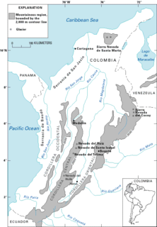
Ancash is a department of northern Peru. It is bordered by the departments of La Libertad on the north, Huánuco and Pasco on the east, Lima on the south, and the Pacific Ocean on the west. Its capital is the city of Huaraz, and its largest city and port is Chimbote. The name of the region originates from the Quechua word anqash, from anqas (blue) or from anka (eagle).
Tierra caliente is an informal term used in Latin America to refer to places with a distinctly tropical climate. These are usually regions from sea level from 0–3,000 feet. The Peruvian geographer Javier Pulgar Vidal used the altitude of 1,000 m as the border between the tropical rain forest and the subtropical cloud forest.
Tierra templada is a pseudoclimatological term used in Latin America to refer to places which are either located in the tropics at a moderately high elevation or are marginally outside the astronomical tropics, producing a somewhat cooler overall climate than that found in the tropical lowlands, the zone of which is known as the tierra caliente.
In Latin America, tierra fría are mountain locations where high elevation results in a markedly cooler climate than that encountered in the lowlands at a comparable latitude. The combination of low latitude and high altitude — typically between approximately 6,000 ft and 10,000 ft in locations within 10° of the equator — produces a climate that falls into the same category as many oceanic climates found along the west coasts of the continents within the temperate zones — mild temperatures all year round, with monthly averages ranging from about 10°C (50°F) in the coldest months to about 18°C (64.4°F) in the warmest months. Common crops grown in the tierra fría are potatoes, wheat, barley, oats, corn, and rye.
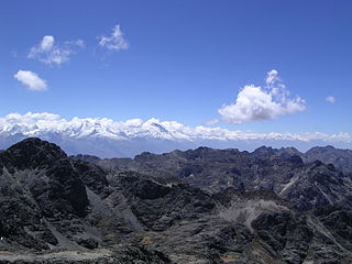
Tierra Helada, also known as Tierra Nevada, is a term used in Latin America to refer to the highest places found within the Andes mountains.
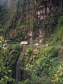
The Yungas is a narrow band of forest along the eastern slope of the Andes Mountains from Peru, Bolivia, and northern Argentina. It is a transitional zone between the Andean highlands and the eastern forests. Like the surrounding areas, the Yungas belong to the Neotropic ecozone; the climate is rainy, humid, and warm.
Huanta Province is the northernmost of the eleven provinces in the Ayacucho region in Peru. The capital of the Huanta province is the city of Huanta.
The Natural History Museum in Lima, is Peru's most important museum of natural history. It was established in 1918 and belongs to the National University of San Marcos.
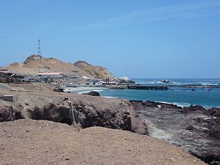
The Chala or "Coast" is one of the eight natural regions in Peru. It is formed by all the western lands that arise from sea level up to the height of 500 meters. The coastal desert of Peru is largely devoid of vegetation but a unique fog and mist-fed ecosystem called Lomas is scattered among hills near the Pacific coast as elevations up to 1,000 metres (3,300 ft).
Quechua is one of the eight Natural Regions of Peru and is between 2,300 and 3,500 m above sea level. It is composed of big valleys divided by rivers fed by estival rains.
Suni or Jalca is one of the eight Natural Regions of Peru. It is located in the Andes at an altitude between 3,500 and 4,000 metres above sea level. Suni has a dry and cold weather and there are many glacial valleys.
Janca is one of the eight Natural Regions of Peru. It is located in the frozen heights where the condor lives.
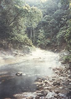
Rupa-Rupa or High Jungle is one of the eight natural regions of Peru. It is located between 400 and 1,000 m above the sea level. This region has many long, narrow valleys and fluvial mountain trails. The weather is warm, humid, and rainy.
When the Spanish arrived, they divided Peru into three main regions: the coastal region, that is bounded by the Pacific Ocean; the highlands, that is located on the Andean Heights, and the jungle, that is located on the Amazonian Jungle. But Javier Pulgar Vidal (es), a geographer who studied the biogeographic reality of the Peruvian territory for a long time, proposed the creation of eight Natural Regions. In 1941, he presented his thesis "Las Ocho Regiones Naturales del Perú" at the III General Assembly of the Pan-American Institute of Geography and History.
Cutervo National Park , established in 1961, is the oldest protected area in Peru. It is located in the northern Peruvian Andes, in the region of Cajamarca. The park was extended to 8,214 hectares (31.71 sq mi) and protects areas of Andean montane forests and paramo for headwater conservation. Moreover, those areas are the habitat of animal species like the spectacled bear, the mountain tapir, and the oilbird; and plant species like the Andean wax palms.
Tambopata National Reserve is a Peruvian nature reserve located in the southeastern region of Madre de Dios. It was established on September 4, 2000, by decree of President Alberto Fujimori. The reserve protects several ecosystems of the tropical rainforest for the preservation of such forest and the sustainable use of forest resources by the peoples around the reserve.
The Puna grassland ecoregion, of the montane grasslands and shrublands biome, is found in the central Andes Mountains of South America. It is considered one of the eight Natural Regions in Peru, but extends south, across Bolivia, as far as northern Argentina and Chile. The term puna encompasses diverse ecosystems of the high Central Andes above 3200–3400 m.
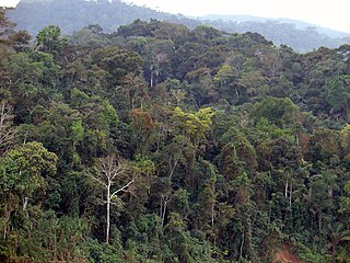
Peruvian Amazonia is the area of the Amazon rainforest included within the country of Peru, from east of the Andes to the borders with Ecuador, Colombia, Brazil and Bolivia. This region comprises 60% of the country and is marked by a large degree of biodiversity. Peru has the second-largest portion of the Amazon rainforest after the Brazilian Amazon.
Altitudinal zonation in mountainous regions describes the natural layering of ecosystems that occurs at distinct elevations due to varying environmental conditions. Temperature, humidity, soil composition, and solar radiation are important factors in determining altitudinal zones, which consequently support different vegetation and animal species. Altitudinal zonation was first hypothesized by geographer Alexander von Humboldt who noticed that temperature drops with increasing elevation. Zonation also occurs in intertidal and marine environments, as well as on shorelines and in wetlands. Scientist C. Hart Merriam observed that changes in vegetation and animals in altitudinal zones map onto changes expected with increased latitude in his concept of life zones. Today, altitudinal zonation represents a core concept in mountain research.
This page is based on this Wikipedia article Text is available under the CC BY-SA 4.0 license; additional terms may apply. Images, videos and audio are available under their respective licenses.