
The Bureau of Land Management (BLM) is an agency within the United States Department of the Interior responsible for administering federal lands. Headquartered in Grand Junction, Colorado, and with oversight over 247.3 million acres (1,001,000 km2), it governs one eighth of the country's landmass.

Jupiter is the northernmost town in Palm Beach County, Florida, United States. According to the 2020 Census, the town had a population of 61,047 as of April 1, 2020. It is 87 miles north of Miami, and the northernmost community in the Miami metropolitan area, home to 6,012,331 people in a 2015 Census Bureau estimate. Jupiter was rated as the 12th Best Beach Town in the United States by WalletHub in 2018, and as the 9th Happiest Seaside Town in the United States by Coastal Living in 2012.

The Grand Staircase–Escalante National Monument (GSENM) is a United States national monument protecting the Grand Staircase, the Kaiparowits Plateau, and the Canyons of the Escalante in southern Utah. It was established in 1996 by President Bill Clinton under the authority of the Antiquities Act with 1.7 million acres of land, later expanded to 1,880,461 acres (7,610 km2). In 2017, the monument's size was reduced by half in a succeeding presidential proclamation, and it was restored in 2021. The land is among the most remote in the country; it was the last to be mapped in the contiguous United States.

National Conservation Area is a designation for certain protected areas in the United States. They are nature conservation areas managed by the Bureau of Land Management (BLM) under the National Landscape Conservation System.
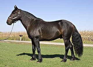
The mustang is a free-roaming horse of the Western United States, descended from horses brought to the Americas by the Spanish. Mustangs are often referred to as wild horses, but because they are descended from once-domesticated animals, they are actually feral horses. The original mustangs were Colonial Spanish horses, but many other breeds and types of horses contributed to the modern mustang, now resulting in varying phenotypes. Some free-roaming horses are relatively unchanged from the original Spanish stock, most strongly represented in the most isolated populations.

The Yaquina Head Light, also known early in its existence as the Cape Foulweather Lighthouse, is a lighthouse on the Oregon Coast of the United States. It is located in Lincoln County, near the mouth of the Yaquina River near Newport at Yaquina Head. The tower stands 93 feet (28 m) tall, and is the tallest lighthouse in Oregon.

Amboy Crater is an extinct cinder cone volcano that rises above a 70-square-kilometer (27 sq mi) lava field in the eastern Mojave Desert of southern California, within Mojave Trails National Monument.

A national recreation area (NRA) is a protected area in the United States established by an Act of Congress to preserve enhanced recreational opportunities in places with significant natural and scenic resources. There are 40 NRAs, which emphasize a variety of activities for visitors, including hiking, camping, boating, fishing, swimming, biking, horseback riding, and wildlife viewing, in areas that include multiple-use management for both conservation and limited utilization of natural resources. They have diverse features and contexts, being established around reservoirs, in urban areas, and within forests. Due to their size, diversity of activities, and proximity to population centers, NRAs are among the most visited units of the National Park System, with six among the thirty most visited sites.

Grand Canyon–Parashant National Monument is located on the northern edge of the Grand Canyon in northwest Arizona. The monument was established by Presidential Proclamation 7265 on January 11, 2000.

Yaquina Head is a headland extending into the Pacific Ocean north of Newport, in the U.S. state of Oregon. It is the site of the Yaquina Head Light, and is managed as Yaquina Head Outstanding Natural Area by the Bureau of Land Management. It is part of the National Landscape Conservation System, commonly known as the National Conservation Lands.

The Jupiter Inlet Light is located in Jupiter, Florida, on the north side of the Jupiter Inlet. The site for the lighthouse was chosen in 1853. It is located between Cape Canaveral Light and Hillsboro Inlet Light. The lighthouse was designed by then Lieutenant George G. Meade of the Bureau of Topographical Engineers. Meade's design was subsequently modified by Lieutenant William Raynolds. The Jupiter Inlet silted shut in 1854, forcing all building supplies to be shipped in light boats down the Indian River. Work was interrupted from 1856 to 1858 by the Third Seminole War. The lighthouse was completed under the supervision of Captain Edward A. Yorke in 1860 at a cost of more than $60,000.

National Conservation Lands, formally known as the National Landscape Conservation System, is a 35-million-acre (140,000 km2) collection of lands in 873 federally recognized areas considered to be the crown jewels of the American West. These lands represent 10% of the 258 million acres (1,040,000 km2) managed by the Bureau of Land Management (BLM). The BLM is the largest federal public land manager and is responsible for over 40% of all the federal public land in the nation. The other major federal public land managers include the US Forest Service (USFS), National Park Service (NPS), and the US Fish and Wildlife Service (USFWS).

The Little Sahara Recreation Area is a large area of sand dunes, hills and sagebrush flats located in the northeast corner of the Sevier Desert in Juab County in the west central part of Utah, United States.

A wilderness study area (WSA) contains undeveloped United States federal land retaining its primeval character and influence, without permanent improvements or human habitation, and managed to preserve its natural conditions. In spite of this, WSAs are not included in the National Wilderness Preservation System.

The California Coastal National Monument is located along the entire coastline of the U.S. state of California. This monument ensures the protection of all islets, reefs and rock outcroppings along the coast of California within 12 nautical miles (22 km) of shore along the entire 840-mile (1,350 km) long coastline. Conservative estimates are for at least 20,000 such outcroppings. The monument was created by Bill Clinton via Presidential proclamation on January 11, 2000, with the authority in section two of the Antiquities Act of 1906. As of 2014, the monument has expanded to 2,272 acres (919 ha). The U.S. Bureau of Land Management, an agency of the U.S. Department of the Interior that manages the monument, has developed gateways in cooperation with other agencies along the California coast to introduce the monument to the public. These include the Trinidad, Point Arena, Fort Bragg-Mendocino, Pigeon Point Lighthouse, Piedras Blancas State Marine Reserve and Marine Conservation Area, and the Palos Verdes Peninsula. Although being the most-viewed national monument in California, people are usually unaware that the entire coastline is a national monument.

Patos Island Lighthouse is an active aid to navigation overlooking the Strait of Georgia at Alden Point on the western tip of Patos Island in the San Juan Islands, San Juan County, Washington, in the United States. The station is the northernmost in the San Juan Islands and marks the division point between the eastern and western passages into the Strait of Juan de Fuca.

According to the California Protected Areas Database (CPAD), in the state of California, United States, there are over 14,000 inventoried protected areas administered by public agencies and non-profits. In addition, there are private conservation areas and other easements. They include almost one-third of California's scenic coastline, including coastal wetlands, estuaries, beaches, and dune systems. The California State Parks system alone has 270 units and covers 1.3 million acres (5,300 km2), with over 280 miles (450 km) of coastline, 625 miles (1,006 km) of lake and river frontage, nearly 18,000 campsites, and 3,000 miles (5,000 km) of hiking, biking, and equestrian trails.

Areas of Critical Environmental Concern (ACEC) is a conservation ecology program in the Western United States, managed by the Bureau of Land Management (BLM). The ACEC program was conceived in the 1976 Federal Lands Policy and Management Act (FLPMA), which established the first conservation ecology mandate for the BLM. The FLPMA mandate directs the BLM to protect important riparian corridors, threatened and endangered species habitats, cultural and archeological resources, as well as unique scenic landscapes that the agency assesses as in need of special management attention.

Piedras Blancas Light Station is located at Point Piedras Blancas, about 5.5 miles (8.9 km) west by northwest of San Simeon, California. It was added to the California Coastal National Monument in 2017.

San Juan Islands National Monument is a U.S. National Monument located in the Salish Sea in the state of Washington. The monument protects archaeological sites of the Coast Salish peoples, lighthouses and relics of early European American settlers in the Pacific Northwest, and biodiversity of the island life in the region. The monument was created from existing federal land by President Barack Obama on March 25, 2013 under the Antiquities Act.
