The Yaquina Head Light, also known early in its existence as the Cape Foulweather Lighthouse, is a lighthouse on the Oregon Coast of the United States, established in 1873. It is located in Lincoln County, near the mouth of the Yaquina River near Newport at Yaquina Head. The tower stands 93 feet (28 m) tall, and is the tallest lighthouse in Oregon.

The West Point Light, also known as the Discovery Park Lighthouse, is an active aid to navigation on Seattle, Washington's West Point, which juts into Puget Sound and marks the northern extent of Elliott Bay. The lighthouse is similar in design to the Point No Point Light and was added to the National Register of Historic Places in 1977. It is a main feature of Seattle's Discovery Park.

West Quoddy Head, in Quoddy Head State Park, Lubec, Maine, is the easternmost point of the contiguous United States. In 1808 a lighthouse was constructed at the site to guide ships through the Quoddy Narrows. The current tower, with distinctive red-and-white stripes, was constructed in 1858 and is an active aid to navigation. The 3rd order Fresnel lens is the only 3rd order and one of only eight Fresnel lenses still in use on the Maine Coast.

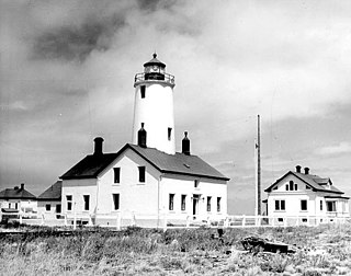
The Point Wilson Light is an active aid to navigation located in Fort Worden State Park near Port Townsend, Jefferson County, Washington. It is one of the most important navigational aids in the state, overlooking the entrance to Admiralty Inlet, the waterway connecting the Strait of Juan de Fuca and Puget Sound. The lighthouse was listed on the Washington State Heritage Register and the National Register of Historic Places in 1971.

East Brother Island Lighthouse is a lighthouse located on East Brother Island in San Rafael Bay, near the tip of Point San Pablo in Richmond, California. It marks the entrance to San Pablo Bay from San Francisco Bay.

The original Point Loma Lighthouse is a historic lighthouse located on the Point Loma peninsula at the mouth of San Diego Bay in San Diego, California. It is situated in the Cabrillo National Monument. It is no longer in operation as a lighthouse but is open to the public as a museum. It is sometimes erroneously called the "Old Spanish Lighthouse", but in fact it was not built during San Diego's Spanish or Mexican eras; it was built in 1855 by the United States government after California's admission as a state.

The Burrows Island Light is a lighthouse on the western tip of Burrows Island, facing Rosario Strait, near Anacortes, in Skagit County, Washington.

Cattle Point Lighthouse is a lighthouse on the southeastern tip of San Juan Island overlooking the Strait of Juan de Fuca where the Haro Straits meet the San Juan Channel, in San Juan County, Washington. The light lies adjacent to the state's Cattle Point Natural Resources Conservation Area and, since 2013, is part of the San Juan Islands National Monument.

The Lime Kiln Light is a functioning navigational aid located on Lime Kiln Point overlooking Dead Man's Bay on the western side of San Juan Island, San Juan County, Washington, in the United States. It guides ships through the Haro Straits and is part of Lime Kiln Point State Park, which offers tours during summer months.
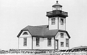
The New Dungeness Lighthouse is a functioning aid to navigation on the Strait of Juan de Fuca, located on the Dungeness Spit in the Dungeness National Wildlife Refuge near Sequim, Clallam County, in the U.S. state of Washington. It has been in continuous operation since 1857, although the current lighthouse tower is 26 feet (7.9 m) shorter than when first constructed.

Point No Point Light is an operational aid to navigation on the northeastern tip of the Kitsap Peninsula on the west side of Puget Sound, at Point No Point where Admiralty Inlet joins Puget Sound, near the small community of Hansville, Kitsap County, in the U.S. state of Washington. Point No Point Light is considered the oldest lighthouse on Puget Sound and is listed on the National Register of Historic Places.
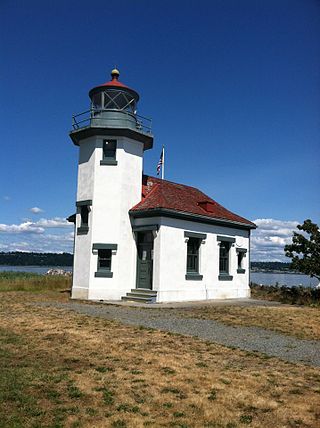
The Point Robinson Light is an operational aid to navigation and historic lighthouse on Puget Sound, located at Point Robinson, the easternmost point of Maury Island, King County, in the U.S. state of Washington. The site was listed on the National Register of Historic Places in 2004.

The Turn Point Light Station is an active aid to navigation overlooking Haro Strait from the western tip of Stuart Island, San Juan County, Washington, in the northwest of the United States. The light marks a sharp turn in the shipping lanes at the transition between Haro Strait and Boundary Pass.

Alcatraz Island Lighthouse is a lighthouse—the first one built on the U.S. West Coast—located on Alcatraz Island in California's San Francisco Bay. It is located at the southern end of the island near the entrance to the prison. The first light house on the island was completed in 1854, and served the bay during its time as a Citadel and military prison. It was replaced by a taller concrete tower built in 1909 to the south of the original one which was demolished after it was damaged due to earthquake in 1906. The automation of the lighthouse with a modern beacon took place in 1963, the year Alcatraz closed as the Alcatraz Federal Penitentiary. It is the oldest light station on the island with a modern beacon and is part of the museum on the island. Although when viewed from afar it easily looks the tallest structure on Alcatraz, it is actually shorter than the Alcatraz Water Tower, but as it lies on higher ground it looks much taller.

Point Cabrillo Light is a lighthouse in northern California, United States, between Point Arena and Cape Mendocino, just south of the community of Caspar. It has been a federal aid to navigation since 1909. It is part of the California state park system as Point Cabrillo Light Station State Historic Park.

Point Fermin Light is a lighthouse on Point Fermin in San Pedro, California.

Crossover Island Light is a lighthouse on the Saint Lawrence River in New York state near the Canada–United States border.
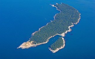
Patos Island is a small island in the San Juan Islands of the U.S. state of Washington. Since 1893, it has been home to the Patos Island Lighthouse, guiding vessels through Boundary Pass between Canada and the United States. The name comes from the Spanish pato, meaning "duck," which was given to the island in 1792 by Commander Dionisio Alcalá Galiano of the Sutil and Captain Cayetano Valdés y Flores of the Mexicana.
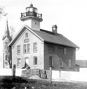
The Port Washington Light is a historical lighthouse in Port Washington, Wisconsin. Replaced by the Port Washington Breakwater Light and converted to a normal dwelling, it was restored with the assistance of the Grand Duchy of Luxembourg and currently serves as a museum.
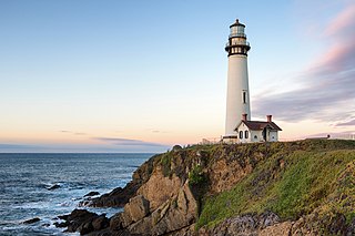
Pigeon Point Light Station or Pigeon Point Lighthouse is a lighthouse built in 1871 to guide ships on the Pacific coast of California. It is the tallest lighthouse on the West Coast of the United States. It is still an active Coast Guard aid to navigation. Pigeon Point Light Station is located on the coastal highway, 5 miles (8 km) south of Pescadero, California, between Santa Cruz and San Francisco. The 115-foot (35 m), white masonry tower, resembles the typical New England structure.