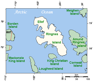
Ellef Ringnes Island is an uninhabited island and one of the Sverdrup Islands in the Qikiqtaaluk Region, Nunavut, Canada. A member of the Queen Elizabeth Islands and Arctic Archipelago, it is located in the Arctic Ocean, east of Borden Island, and west of Amund Ringnes Island. It has an area of 11,295 km2 (4,361 sq mi), making it the 69th largest island in the world and Canada's 16th largest island. Its highest mount is 260 m (850 ft).

Thermokarst is a type of terrain characterised by very irregular surfaces of marshy hollows and small hummocks formed as ice-rich permafrost thaws. The land surface type occurs in Arctic areas, and on a smaller scale in mountainous areas such as the Himalayas and the Swiss Alps.

Pingos are intrapermafrost ice-cored hills, 3–70 m (10–230 ft) high and 30–1,000 m (98–3,281 ft) in diameter. They are typically conical in shape and grow and persist only in permafrost environments, such as the Arctic and subarctic. A pingo is a periglacial landform, which is defined as a non-glacial landform or process linked to colder climates. It is estimated that there are more than 11,000 pingos on Earth. The Tuktoyaktuk peninsula area has the greatest concentration of pingos in the world with a total of 1,350 pingos. There is currently remarkably limited data on pingos.

Rock glaciers are distinctive geomorphological landforms, consisting either of angular rock debris frozen in interstitial ice, former "true" glaciers overlain by a layer of talus, or something in-between. Rock glaciers are normally found at high latitudes and/or elevations, and may extend outward and downslope from talus cones, glaciers or terminal moraines of glaciers.

The International Permafrost Association (IPA), founded in 1983, is an international professional body formed to foster the dissemination of knowledge concerning permafrost and to promote cooperation among individuals and national or international organisations engaged in scientific investigation and engineering work related to permafrost and seasonally frozen ground. The IPA became an Affiliated Organisation of the International Union of Geological Sciences in July 1989.
A periglacial lake is a lake bordering a glacier, usually found along the fringes of large ice sheets.

Patterned ground is the distinct and often symmetrical natural pattern of geometric shapes formed by the deformation of ground material in periglacial regions. It is typically found in remote regions of the Arctic, Antarctica, and the Outback in Australia, but is also found anywhere that freezing and thawing of soil alternate; patterned ground has also been observed in the hyper-arid Atacama Desert and on Mars. The geometric shapes and patterns associated with patterned ground are often mistaken as artistic human creations. The mechanism of the formation of patterned ground had long puzzled scientists but the introduction of computer-generated geological models in the past 20 years has allowed scientists to relate it to frost heaving, the expansion that occurs when wet, fine-grained, and porous soils freeze.

Palsas are peat mounds with a permanently frozen peat and mineral soil core. They are a typical phenomenon in the polar and subpolar zone of discontinuous permafrost. One of their characteristics is having steep slopes that rises above the mire surface. This leads to the accumulation of large amounts of snow around them. The summits of the palsas are free of snow even in winter, because the wind carries the snow and deposits on the slopes and elsewhere on the flat mire surface. Palsas can be up to 150 m in diameter and can reach a height of 12 m.
Earth Surface Processes and Landforms is a peer-reviewed scientific journal published by John Wiley & Sons on behalf of the British Society for Geomorphology. It covers geomorphology and more in general all aspects of Earth sciences dealing with the Earth surface. The journal was established in 1976 as Earth Surface Processes, obtaining its current name in 1981. The journal primarily publishes original research papers. It also publishes Earth Surface Exchanges which include commentaries on issues of particular geomorphological interest, discussions of published papers, shorter journal articles suitable for rapid publication, and commissioned reviews on key aspects of geomorphological science. Foci include the physical geography of rivers, valleys, glaciers, mountains, hills, slopes, coasts, deserts, and estuary environments, along with research into Holocene, Pleistocene, or Quaternary science. The editor-in-chief is Stuart Lane.
In geomorphology, cryoplanation or is a term used to both describe and explain the formation of plains, terraces and pediments in periglacial environments. Uncertainty surrounds the term, and the effectiveness of the cryoplanation process is held to be limited meaning it can only produce small terraces. Instead, many of so-called cryoplanation terraces are likely an expression of the underlying lithology and rock structure rather than being unique products of cold-climate processes.
Ole Humlum is a Danish professor emeritus of physical geography at the University of Oslo, Department of Geosciences and adjunct professor of physical geography at the University Centre in Svalbard. His academic focus includes glacial and periglacial geomorphology and climatology.

Periglaciation describes geomorphic processes that result from seasonal thawing and freezing, very often in areas of permafrost. The meltwater may refreeze in ice wedges and other structures. "Periglacial" originally suggested an environment located on the margin of past glaciers. However, freeze and thaw cycles influence landscapes also outside areas of past glaciation. Therefore, periglacial environments are anywhere when freezing and thawing modify the landscape in a significant manner.
In geomorphology fluvio-thermal erosion is the combined mechanical and thermal erosion of an unfrozen river or stream against ice-rich soils and sediments. The erosional process includes the thawing of ice sediments by a strong water flow and once the surface is unfrozen, mechanical erosion occurs only if hydraulic forces are powerful enough to incise the riverbank material. This kind of erosion sometimes causes the banks to collapse into the river, and when this occurs collapses are commonly controlled by ice wedges. Rivers where this process has been observed include the Lena, the Colville River delta, and the Yukon River.
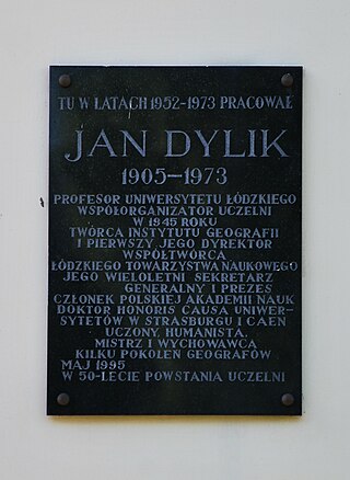
Biuletyn Peryglacjalny was a scientific journal covering research on periglacial geomorphology. It was established in 1954 in Łódź by Polish geomorphologist Jan Dylik, who was its editor-in-chief until 1972. The journal ceased publication after 39 issues in 2000, after having played an important role in the development of periglacial geomorphology.
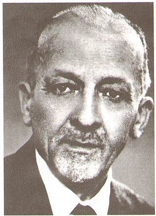
Jan Dylik was a Polish geography professor at the University of Łódz. He was born in Łódź on 19 June 1905. In 1925 he begain post-secondary studies at Jagiellonian University. He then went on to attend Adam Mickiewicz University in Poznań to pursue research and a doctoral degree. He found himself fascinated by the differences in geology between the Greater Poland Voivodeship and the Łódź Voivodeship. He collaborated with Stanisław Lencewicz on a project to analyze the Łódź region's geology and geomorphology. The resulting paper was published in 1927, and for many years was considered the only source of information on the geology of Łódź. From 1928-1930, while still balancing the responsibilities of research, he worked as an assistant in the National Museum of Archaeology in Poland. In 1930, he completed his doctoral degree for a dissertation on Stone Age settlements in the Warta River Gorge. After obtaining his doctoral degree, Dylik sought funding from the National Culture Fund of Poland in order to travel and study abroad. In 1932, funding was granted for a research trip to Austria, Germany, Denmark, and Sweden. The research obtained during this trip was the basis for a 1935 paper he published on Neolithic-era Settlements in the Northern Vienna Basin. This trip inspired him to travel yet again, and in 1934, another grant was offered for a research trip to Sweden, Finland, Estonia, and Latvia. After his research trip in 1934, he served on the International Geographic Congress in Warsaw as the Secretary of the Section on Prehistoric and Historical Geography, where he authored and presented a paper on the geographical location of prehistoric settlements and the historic development of ecumenism in western Poland. This marked the height of Dylik's association with archaeology, as shortly after this period, his career shifted away from anthropological geography toward pure geology. He still maintained close ties with his contacts in the field of archaeology, and continued to collaborate with them for future research. He also forever remained an archaeologist at heart in some regards, keeping his habit of treating geological sites with the same deal of care and meticulousness as if they were archaeological dig sites.
Walery Władysław Daniel Łoziński (1880–1944) was a Polish geographer, geomorphologist and soil scientist known for introducing the concept of periglaciation into geomorphology in 1909. Łoziński extended the work of Swedish geologist Johan Gunnar Andersson who had written about periglacial phenomena in Bjørnøya and the Falkland Islands. The concept of "periglaciation" was the subject of an intensive discussion at the 1910 International Geological Congress held in Stockholm.
Stratified slope deposits or grèzes litées are accumulations of debris that are traditionally associated with periglaciation but that can also form in other settings. The deposits have a weak sorting and a coarse bedding. Stratified slope deposits are usually found at the lower slopes of valleys where thicknesses vary but may exceed 10 meters. Periglacial stratified slope deposits are thought to be the result of rock fragmented by frost being accumulated downslope.

Climatic geomorphology is the study of the role of climate in shaping landforms and the earth-surface processes. An approach used in climatic geomorphology is to study relict landforms to infer ancient climates. Being often concerned about past climates climatic geomorphology considered sometimes to be an aspect of historical geology. Since landscape features in one region might have evolved under climates different from those of the present, studying climatically disparate regions might help understand present-day landscapes. For example, Julius Büdel studied both cold-climate processes in Svalbard and weathering processes in tropical India to understand the origin of the relief of Central Europe, which he argued was a palimpsest of landforms formed at different times and under different climates.
Retrogressive thaw slumps (RTS), are a type of landslide that occur in the terrestrial Arctic's permafrost region of the circumpolar Northern Hemisphere when an ice-rich section thaws. RTSs develop quickly and can extend across several hectares modifying Arctic coastlines and permafrost terrain. They are the most active and dynamic feature of thermokarst—the collapse of the land surface as ground ice melts. They are thermokarst slope failures due to abrupt thawing of ice-rich permafrost or glaciated terrains. These horseshoe-shaped landslides contribute to the thawing of hectares of permafrost annually and are considered to be one of the most active and dynamic features of thermokarst—the "processes and landforms that involve collapse of the land surface as a result of the melting of ground ice." They are found in permafrost or glaciated regions of the Northern Hemisphere—the Tibetan Plateau, Siberia, from the Himalayas to northern Greenland, and in northern Canada's Northwest Territories (NWT), the Yukon Territories, Nunavut, and Nunavik and in the American state of Alaska. The largest RTS in the world is in Siberia—the Batagaika Crater, also called a "megaslump", is one-kilometre-long and 100 metres (330 ft) deep and it grows a 100 feet (30 m) annually. The land began to sink, and the Batagaika Crater began to form in the 1960s, following clear-cutting of a section of forested area.