Celestial globes show the apparent positions of the stars in the sky. They omit the Sun, Moon, and planets because the positions of these bodies vary relative to those of the stars, but the ecliptic, along which the Sun moves, is indicated.

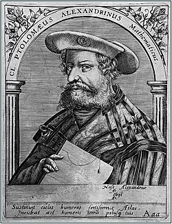
Claudius Ptolemy was an Alexandrian mathematician, astronomer, astrologer, geographer, and music theorist, who wrote about a dozen scientific treatises, three of which were of importance to later Byzantine, Islamic, and Western European science. The first is the astronomical treatise now known as the Almagest, although it was originally entitled the Mathēmatikē Syntaxis or Mathematical Treatise, and later known as The Greatest Treatise. The second is the Geography, which is a thorough discussion on maps and the geographic knowledge of the Greco-Roman world. The third is the astrological treatise in which he attempted to adapt horoscopic astrology to the Aristotelian natural philosophy of his day. This is sometimes known as the Apotelesmatika but more commonly known as the Tetrábiblos, from the Koine Greek meaning "Four Books", or by its Latin equivalent Quadripartite.

An astrolabe is an astronomical instrument dating back to ancient times. It serves as a star chart and physical model of visible heavenly bodies. Its various functions also make it an elaborate inclinometer and an analog calculation device capable of working out several kinds of problems in astronomy. In its simplest form it is a metal disc with a pattern of wires, cutouts, and perforations that allows a user to calculate astronomical positions precisely. Historically used by astronomers, it is able to measure the altitude above the horizon of a celestial body, day or night; it can be used to identify stars or planets, to determine local latitude given local time, to survey, or to triangulate. It was used in classical antiquity, the Islamic Golden Age, the European Middle Ages and the Age of Discovery for all these purposes.

In mathematics, a stereographic projection is a perspective projection of the sphere, through a specific point on the sphere, onto a plane perpendicular to the diameter through the point. It is a smooth, bijective function from the entire sphere except the center of projection to the entire plane. It maps circles on the sphere to circles or lines on the plane, and is conformal, meaning that it preserves angles at which curves meet and thus locally approximately preserves shapes. It is neither isometric nor equiareal.
The Almagest is a 2nd-century mathematical and astronomical treatise on the apparent motions of the stars and planetary paths, written by Claudius Ptolemy in Koine Greek. One of the most influential scientific texts in history, it canonized a geocentric model of the Universe that was accepted for more than 1,200 years from its origin in Hellenistic Alexandria, in the medieval Byzantine and Islamic worlds, and in Western Europe through the Middle Ages and early Renaissance until Copernicus. It is also a key source of information about ancient Greek astronomy.
Theon of Alexandria was a Greek scholar and mathematician who lived in Alexandria, Egypt. He edited and arranged Euclid's Elements and wrote commentaries on works by Euclid and Ptolemy. His daughter Hypatia also won fame as a mathematician.
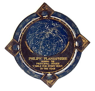
In astronomy, a planisphere is a star chart analog computing instrument in the form of two adjustable disks that rotate on a common pivot. It can be adjusted to display the visible stars for any time and date. It is an instrument to assist in learning how to recognize stars and constellations. The astrolabe, an instrument that has its origins in Hellenistic astronomy, is a predecessor of the modern planisphere. The term planisphere contrasts with armillary sphere, where the celestial sphere is represented by a three-dimensional framework of rings.

Abū al-ʿAbbās Aḥmad ibn Muḥammad ibn Kathīr al-Farghānī also known as Alfraganus in the West, was an astronomer in the Abbasid court in Baghdad, and one of the most famous astronomers in the 9th century. Al-Farghani composed several works on astronomy and astronomical equipment that were widely distributed in Arabic and Latin and were influential to many scientists. His best known work, Kitāb fī Jawāmiʿ ʿIlm al-Nujūmi, was an extensive summary of Ptolemy's Almagest containing revised and more accurate experimental data. Christopher Columbus used Al Farghani’s calculations for his voyages to America. In addition to making substantial contributions to astronomy, al-Farghani also worked as an engineer, supervising construction projects on rivers in Cairo, Egypt. The lunar crater Alfraganus is named after him.
Abū’l-‘Abbās al-Faḍl ibn Ḥātim al-Nairīzī was a Persian mathematician and astronomer from Nayriz, now in Fars Province, Iran.

Medieval Islamic astronomy comprises the astronomical developments made in the Islamic world, particularly during the Islamic Golden Age, and mostly written in the Arabic language. These developments mostly took place in the Middle East, Central Asia, Al-Andalus, and North Africa, and later in the Far East and India. It closely parallels the genesis of other Islamic sciences in its assimilation of foreign material and the amalgamation of the disparate elements of that material to create a science with Islamic characteristics. These included Greek, Sassanid, and Indian works in particular, which were translated and built upon.

The Geography, also known by its Latin names as the Geographia and the Cosmographia, is a gazetteer, an atlas, and a treatise on cartography, compiling the geographical knowledge of the 2nd-century Roman Empire. Originally written by Claudius Ptolemy in Greek at Alexandria around AD 150, the work was a revision of a now-lost atlas by Marinus of Tyre using additional Roman and Persian gazetteers and new principles. Its translation into Arabic in the 9th century was highly influential on the geographical knowledge and cartographic traditions of the Islamic world. Alongside the works of Islamic scholars - and the commentary containing revised and more accurate data by Alfraganus - Ptolemy's work was subsequently highly influential on Medieval and Renaissance Europe.
In mathematics, a projection is an idempotent mapping of a set into a subset. In this case, idempotent means that projecting twice is the same as projecting once. The restriction to a subspace of a projection is also called a projection, even if the idempotence property is lost. An everyday example of a projection is the casting of shadows onto a plane : the projection of a point is its shadow on the sheet of paper, and the projection (shadow) of a point on the sheet of paper is that point itself (idempotency). The shadow of a three-dimensional sphere is a closed disk. Originally, the notion of projection was introduced in Euclidean geometry to denote the projection of the three-dimensional Euclidean space onto a plane in it, like the shadow example. The two main projections of this kind are:

Jordanus de Nemore, also known as Jordanus Nemorarius and Giordano of Nemi, was a thirteenth-century European mathematician and scientist. The literal translation of Jordanus de Nemore would indicate that he was an Italian. He wrote treatises on at least 6 different important mathematical subjects: the science of weights; “algorismi” treatises on practical arithmetic; pure arithmetic; algebra; geometry; and stereographic projection. Most of these treatises exist in several versions or reworkings from the Middle Ages. We know nothing about him personally, other than the approximate date of his work.

The Toledo School of Translators is the group of scholars who worked together in the city of Toledo during the 12th and 13th centuries, to translate many of the Islamic philosophy and scientific works from Classical Arabic into Medieval Latin.
Qusta ibn Luqa, also known as Costa ben Luca or Constabulus (820–912) was a Syrian Melkite Christian physician, philosopher, astronomer, mathematician and translator. He was born in Baalbek. Travelling to parts of the Byzantine Empire, he brought back Greek texts and translated them into Arabic.
Rudolf (Rudolph) of Bruges was a Flemish translator from Arabic into Latin active in the twelfth century who worked at the Toledo School of Translators.
Medieval Islamic geography and cartography refer to the study of geography and cartography in the Muslim world during the Islamic Golden Age. Muslim scholars made advances to the map-making traditions of earlier cultures, particularly the Hellenistic geographers Ptolemy and Marinus of Tyre, combined with what explorers and merchants learned in their travels across the Old World (Afro-Eurasia). Islamic geography had three major fields: exploration and navigation, physical geography, and cartography and mathematical geography. Islamic geography reached its apex with Muhammad al-Idrisi in the 12th century.

A quadrant is an instrument used to measure angles up to 90°. Different versions of this instrument could be used to calculate various readings, such as longitude, latitude, and time of day. Its earliest recorded usage was in ancient India in Rigvedic times by Rishi Atri to observe a solar eclipse. It was then proposed by Ptolemy as a better kind of astrolabe. Several different variations of the instrument were later produced by medieval Muslim astronomers. Mural quadrants were important astronomical instruments in 18th-century European observatories, establishing a use for positional astronomy.
The Spherics is a three-volume treatise on spherical geometry written by the Greek mathematician Theodosius of Bithynia in the 2nd century BC.

The stereographic projection, also known as the planisphere projection or the azimuthal conformal projection, is a conformal map projection whose use dates back to antiquity. Like the orthographic projection and gnomonic projection, the stereographic projection is an azimuthal projection, and when on a sphere, also a perspective projection.