Pleasant Hill, Iowa

Last updated

Pleasant Hill, Iowa
Pleasant Hill water tower 1.jpg
Pleasant Hill's water tower, with the city logo
Polk County Iowa Incorporated and Unincorporated areas Pleasant Hill Highlighted.svg
Location of Pleasant Hill, Iowa
Coordinates: 41°35′05″N93°30′59″W / 41.58472°N 93.51639°W / 41.58472; -93.51639
Country United States
State Iowa
County Polk
Area
[1]
  Total10.85 sq mi (28.09 km2)
  Land10.48 sq mi (27.13 km2)
  Water0.37 sq mi (0.96 km2)
Elevation
[2]
906 ft (276 m)
Population
 (2020)
  Total10,147
  Density968.59/sq mi (373.98/km2)
Time zone UTC-6 (Central (CST))
  Summer (DST) UTC-5 (CDT)
ZIP codes
50317, 50327
Area code 515
FIPS code 19-63525
GNIS feature ID2396230 [2]
Website www.pleasanthilliowa.org

Pleasant Hill is a city in Polk County, Iowa, United States. The population was 10,147 at the time of the 2020 census. [3] It is part of the Des Moines metropolitan area. As of July 2005, Pleasant Hill was assigned a ZIP code, 50327.

Contents

History

Pleasant Hill incorporated as a city on May 12, 1956. [4]

1983 explosion

On November 20, 1983, an explosion of an explosives storage bunker just south of Pleasant Hill occurred. Reports were that two teenagers were hunting around the area. One of the teenagers may have shot a bullet from a hill which penetrated the bunker ceiling, which was deemed the probable cause of the explosion. The two teenagers were killed in the explosion, leaving only small pieces of shirts. The explosion was felt 45 miles away from the site. At least 25 homes within a one-mile radius of the explosion suffered damage, doors and windows were blown out, ceilings fell and houses were knocked off their foundations, police said. One house, 300 yards directly up the valley from the shack, suffered an inch-wide crack the entire width of its basement wall. [5] [6]

Geography

According to the United States Census Bureau, the city has a total area of 9.29 square miles (24.06 km2), of which 9.15 square miles (23.70 km2) is land and 0.14 square miles (0.36 km2) is water. [7]

Demographics

Historical populations
YearPop.±%
1960 397    
1970 1,535+286.6%
1980 3,493+127.6%
1990 3,671+5.1%
2000 5,070+38.1%
2010 8,785+73.3%
2020 10,147+15.5%
Source: "U.S. Census website". United States Census Bureau . Retrieved March 29, 2020. and Iowa Data Center
Source:
U.S. Decennial Census [8] [3]

2010 census

As of the census [9] of 2010, there were 8,785 people, 3,395 households, and 2,426 families residing in the city. The population density was 960.1 inhabitants per square mile (370.7/km2). There were 3,587 housing units at an average density of 392.0 per square mile (151.4/km2). The racial makeup of the city was 91.0% White, 2.7% African American, 0.3% Native American, 2.5% Asian, 0.9% from other races, and 2.6% from two or more races. Hispanic or Latino of any race were 4.5% of the population.

There were 3,395 households, of which 38.1% had children under the age of 18 living with them, 56.3% were married couples living together, 11.1% had a female householder with no husband present, 4.1% had a male householder with no wife present, and 28.5% were non-families. 22.7% of all households were made up of individuals, and 8.1% had someone living alone who was 65 years of age or older. The average household size was 2.57 and the average family size was 3.02.

The median age in the city was 35.1 years. 27.4% of residents were under the age of 18; 7.6% were between the ages of 18 and 24; 29.3% were from 25 to 44; 24.4% were from 45 to 64; and 11.3% were 65 years of age or older. The gender makeup of the city was 46.8% male and 53.2% female.

2000 census

As of the census [10] of 2000, there were 5,070 people, 1,900 households, and 1,451 families residing in the city. The population density was 647.1 inhabitants per square mile (249.8/km2). There were 1,966 housing units at an average density of 250.9 per square mile (96.9/km2). The racial makeup of the city was 95.03% White, 0.79% African American, 0.28% Native American, 1.74% Asian, 0.24% Pacific Islander, 1.12% from other races, and 0.81% from two or more races. Hispanic or Latino of any race were 2.43% of the population.

There were 1,900 households, out of which 35.5% had children under the age of 18 living with them, 65.4% were married couples living together, 8.3% had a female householder with no husband present, and 23.6% were non-families. 18.4% of all households were made up of individuals, and 5.3% had someone living alone who was 65 years of age or older. The average household size was 2.63 and the average family size was 2.99.

Age spread: 25.9% under the age of 18, 7.4% from 18 to 24, 31.7% from 25 to 44, 25.5% from 45 to 64, and 9.6% who were 65 years of age or older. The median age was 36 years. For every 100 females, there were 92.0 males. For every 100 females age 18 and over, there were 86.9 males.

The median income for a household in the city was $60,694, and the median income for a family was $68,889. Males had a median income of $42,450 versus $29,697 for females. The per capita income for the city was $25,316. About 0.6% of families and 1.3% of the population were below the poverty line, including none of those under age 18 and 4.7% of those age 65 or over.

Education

Most of Pleasant Hill is part of the Des Moines Public School District, while newer portions of the city are in the Southeast Polk Community School District. The Des Moines district's Pleasant Hill Elementary School and Southeast Polk's Four Mile Elementary School and Southeast Polk Junior and Senior High Schools are located in Pleasant Hill.

Transportation

Transit service in the city is provided by Des Moines Area Regional Transit. Route 10 provides bus service connecting the city to the region. [11]

Related Research Articles

<span class="mw-page-title-main">Polk County, Iowa</span> County in Iowa, United States

Polk County is located in the U.S. state of Iowa. As of the 2020 census, the population was 492,401. It is Iowa's most populous county, and home to over 15% of the state's residents. The county seat is Des Moines, which is also the capital city of Iowa. Polk County is included in the Des Moines–West Des Moines, IA Metropolitan Statistical Area.

<span class="mw-page-title-main">Sheldahl, Iowa</span> City in Iowa, United States

Sheldahl is a city in Polk, Boone, and Story counties in the U.S. state of Iowa. The population was 297 at the time of the 2020 census.

<span class="mw-page-title-main">Granger, Iowa</span> City in Iowa, United States

Granger is a city in Dallas and Polk counties in the U.S. state of Iowa. The population was 1,654 at the time of the 2020 census, up 184% from 583 in 2000. It is part of the Des Moines–West Des Moines Metropolitan Statistical Area.

<span class="mw-page-title-main">Grimes, Iowa</span> City in Iowa, United States

Grimes is a city in Polk and Dallas counties in the U.S. state of Iowa. The population was 15,392 at the time of the 2020 Census. Grimes is part of the Des Moines-West Des Moines metropolitan area.

<span class="mw-page-title-main">Urbandale, Iowa</span> City in Iowa, United States

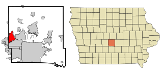
Urbandale is a city in Polk and Dallas counties, Iowa, United States. As of the 2020 U.S. Census, the city population was 45,580. It is part of the Des Moines–West Des Moines Metropolitan Statistical Area.

<span class="mw-page-title-main">Alleman, Iowa</span> City in Iowa, United States

Alleman is a city in Polk County, Iowa, United States. The population was 423 at the 2020 census. It is part of the Des Moines–West Des Moines Metropolitan Statistical Area.

<span class="mw-page-title-main">Altoona, Iowa</span> City in Iowa, United States

Altoona is a city in Polk County, Iowa, United States, and part of the Des Moines metropolitan area. The population was 19,565 at the 2020 census. It is home to the Adventureland amusement park and Prairie Meadows horse racing track and casino.

<span class="mw-page-title-main">Bondurant, Iowa</span> City in Iowa, United States

Bondurant is a city in Polk County, Iowa, United States. The population was 7,365 in the 2020 census, an increase of 90.8% from the 3,860 population in 2010. It is part of the Des Moines–West Des Moines metropolitan statistical area.

<span class="mw-page-title-main">Elkhart, Iowa</span> City in Iowa, United States

Elkhart is a city in Polk County, Iowa, United States. The population was 882 at the time of the 2020 census. It is part of the Des Moines–West Des Moines Metropolitan Statistical Area.

<span class="mw-page-title-main">Johnston, Iowa</span> City in Iowa, United States

Johnston is a city in Polk County, Iowa, United States. The population was 24,064 in the 2020 census, a large increase from the 8,649 population in 2000. It is part of the Des Moines–West Des Moines Metropolitan Statistical Area.

<span class="mw-page-title-main">Polk City, Iowa</span> City in Iowa, United States

Polk City is a city in Polk County, Iowa, United States. The population was 5543 in the 2020 census, an increase from 2,344 in 2000. It is part of the Des Moines–West Des Moines Metropolitan Statistical Area.

<span class="mw-page-title-main">Runnells, Iowa</span> City in Iowa, United States

Runnells is a city in the southeastern corner of Polk County, Iowa, United States. The population was 457 at the time of the 2020 census. It is part of the Des Moines–West Des Moines Metropolitan Statistical Area. Runnells has its own Post Office, located at 112 Brown Street.

<span class="mw-page-title-main">Windsor Heights, Iowa</span> City in Iowa, United States

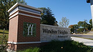
Windsor Heights is a city in Polk County, Iowa, United States. The population was 5,252 at the time of the 2020 census. It is part of the Des Moines–West Des Moines Metropolitan Statistical Area.

<span class="mw-page-title-main">Spring Hill, Iowa</span> City in Iowa, United States

Spring Hill is a city in Warren County, Iowa, United States. The population was 68 at the time of the 2020 census. It is part of the Des Moines–West Des Moines Metropolitan Statistical Area.

<span class="mw-page-title-main">Winger, Minnesota</span> City in Minnesota, United States

Winger is a city in Polk County, Minnesota, United States. It is part of the Grand Forks, ND-MN Metropolitan Statistical Area. The population was 174 at the 2020 census.

<span class="mw-page-title-main">Pleasant Hill, Missouri</span> City in Missouri, United States

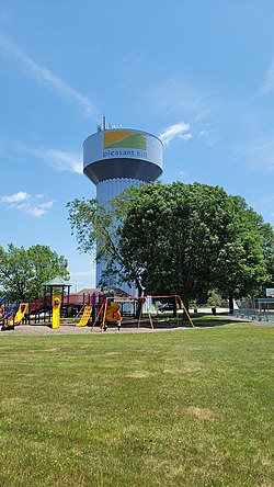
Pleasant Hill is a city in Cass and Jackson counties, Missouri, United States. The population was 8,113 at the 2010 census. It is part of the Kansas City metropolitan area.

<span class="mw-page-title-main">Pleasant Hope, Missouri</span> City in Missouri, United States

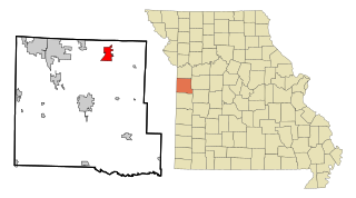
Pleasant Hope is a city in Polk County, Missouri, United States. The population was 614 at the 2010 census. It is part of the Springfield, Missouri Metropolitan Statistical Area.

<span class="mw-page-title-main">Belmont, West Virginia</span> Town in West Virginia, United States

Belmont is a town in Pleasants County, West Virginia, United States. It is part of the Parkersburg–Vienna metropolitan area. The population was 872 at the 2020 census. Belmont was incorporated on April 19, 1946 by the Circuit Court of Pleasants County. The city was named for the beautiful hills in the area.

<span class="mw-page-title-main">Mitchellville, Iowa</span> City in Iowa, United States

Mitchellville is a city located in Polk and Jasper counties in the U.S. state of Iowa. The population was 2,485 at the time of the 2020 census.

<span class="mw-page-title-main">Carlisle, Iowa</span> City in Iowa, United States

Carlisle is a city in Warren and Polk counties in the U.S. state of Iowa. The population was 4,160 at the 2020 census. The city is part of the Des Moines–West Des Moines Metropolitan Statistical Area.

References

  1. "2020 U.S. Gazetteer Files". United States Census Bureau. Retrieved March 16, 2022.
  2. 1 2 U.S. Geological Survey Geographic Names Information System: Pleasant Hill, Iowa
  3. 1 2 "2020 Census State Redistricting Data". census.gov. United states Census Bureau. Retrieved August 12, 2021.
  4. Henning, Barbara Beving Long; Patrice K. Beam (2003). Des Moines and Polk County: Flag on the Prairie. Sun Valley, California: American Historical Press. ISBN   1-892724-34-0.
  5. Ap (November 21, 1983). "AROUND THE NATION; 2 Teen-Agers Missing A Day After Iowa Blast". The New York Times. ISSN   0362-4331 . Retrieved August 13, 2022.
  6. "The Spokesman-Review - Google News Archive Search". news.google.com. Retrieved August 13, 2022.
  7. "US Gazetteer files 2010". United States Census Bureau. Archived from the original on January 25, 2012. Retrieved May 11, 2012.
  8. "Census of Population and Housing". Census.gov. Retrieved June 4, 2015.
  9. "U.S. Census website". United States Census Bureau . Retrieved May 11, 2012.
  10. "U.S. Census website". United States Census Bureau . Retrieved January 31, 2008.
  11. "DART System Map" . Retrieved August 28, 2023.