Mitchellville, Iowa

Last updated

Mitchellville, Iowa
Mitchellville Iowa 20100328 City Hall.JPG
City Hall
Polk County Iowa Incorporated and Unincorporated areas Mitchellville Highlighted.svg
Location of Mitchellville, Iowa
Coordinates: 41°40′06″N93°21′58″W / 41.66833°N 93.36611°W / 41.66833; -93.36611
Country Flag of the United States (23px).png  United States
State Flag of Iowa.svg  Iowa
Counties Polk, Jasper
Area
[1]
  Total2.53 sq mi (6.55 km2)
  Land2.52 sq mi (6.53 km2)
  Water0.01 sq mi (0.01 km2)
Elevation
[2]
955 ft (291 m)
Population
 (2020)
  Total2,485
  Density985.33/sq mi (380.37/km2)
Time zone UTC-6 (Central (CST))
  Summer (DST) UTC-5 (CDT)
ZIP code
50169
Area code 515
FIPS code 19-52950
GNIS feature ID2395360 [2]
Website www.mitchellville.org

Mitchellville is a city located in Polk and Jasper counties in the U.S. state of Iowa. The population was 2,485 at the time of the 2020 census. [3]

Contents

Mitchellville is part of the Des Moines West Des Moines Metropolitan Statistical Area.

The Iowa Correctional Institution for Women is located in Mitchellville.

History

Mitchellville was founded by Thomas Mitchell (1816–1894) in 1856 and it incorporated as a city on September 30, 1875. Mitchell's farm was later purchased by Polk County, becoming Thomas Mitchell Park. [4] Mitchell was the first white settler in Polk County, Iowa. [5]

Geography

According to the United States Census Bureau, the city has a total area of 2.34 square miles (6.06 km2), of which 2.33 square miles (6.03 km2) is land and 0.01 square miles (0.03 km2) is water. [6]

Demographics

Historical populations
YearPop.±%
1880 745    
1890 704−5.5%
1900 768+9.1%
1910 869+13.2%
1920 752−13.5%
1930 702−6.6%
1940 769+9.5%
1950 906+17.8%
1960 957+5.6%
1970 1,341+40.1%
1980 1,530+14.1%
1990 1,670+9.2%
2000 1,715+2.7%
2010 2,254+31.4%
2020 2,485+10.2%
Source: "U.S. Census website". United States Census Bureau . Retrieved March 29, 2020. and Iowa Data Center
Source:
U.S. Decennial Census [7] [3]

2010 census

As of the census [8] of 2010, there were 2,254 people, 651 households, and 430 families living in the city. The population density was 967.4 inhabitants per square mile (373.5/km2). There were 693 housing units at an average density of 297.4 per square mile (114.8/km2). The racial makeup of the city was 91.7% White, 5.8% African American, 0.8% Native American, 0.5% Asian, 0.2% from other races, and 1.0% from two or more races. Hispanic or Latino of any race were 2.4% of the population.

There were 651 households, of which 35.3% had children under the age of 18 living with them, 53.0% were married couples living together, 9.4% had a female householder with no husband present, 3.7% had a male householder with no wife present, and 33.9% were non-families. 27.5% of all households were made up of individuals, and 9.1% had someone living alone who was 65 years of age or older. The average household size was 2.53 and the average family size was 3.12.

The median age in the city was 37.2 years. 20.4% of residents were under the age of 18; 8.8% were between the ages of 18 and 24; 35.2% were from 25 to 44; 25.3% were from 45 to 64; and 10.2% were 65 years of age or older. The gender makeup of the city was 36.5% male and 63.5% female.

The 2010 census includes the prisoners of the Iowa Correctional Institution for Women, whereas the 2000 census did not. This accounts for the drastic change in male/female ratio between 2000 and 2010.

2000 census

As of the census [9] of 2000, there were 1,715 people, 650 households, and 455 families living in the city. The population density was 746.4 inhabitants per square mile (288.2/km2). There were 675 housing units at an average density of 293.8 per square mile (113.4/km2). The racial makeup of the city was 97.49% White, 0.29% African American, 0.12% Native American, 0.70% Asian, 0.41% from other races, and 0.99% from two or more races. Hispanic or Latino of any race were 1.34% of the population.

There were 650 households, out of which 39.4% had children under the age of 18 living with them, 55.7% were married couples living together, 10.8% had a female householder with no husband present, and 30.0% were non-families. 25.5% of all households were made up of individuals, and 10.8% had someone living alone who was 65 years of age or older. The average household size was 2.55 and the average family size was 3.09.

28.9% are under the age of 18, 7.9% from 18 to 24, 29.5% from 25 to 44, 20.0% from 45 to 64, and 13.6% who were 65 years of age or older. The median age was 35 years. For every 100 females, there were 95.6 males. For every 100 females age 18 and over, there were 87.0 males.

The median income for a household in the city was $45,250, and the median income for a family was $52,113. Males had a median income of $34,327 versus $26,202 for females. The per capita income for the city was $18,572. About 4.3% of families and 4.6% of the population were below the poverty line, including 4.9% of those under age 18 and 7.5% of those age 65 or over.

Economy

Iowa Correctional Institution for Women Mitchellville Iowa 20100328 Corectional Ins.JPG
Iowa Correctional Institution for Women

The Iowa Department of Corrections Iowa Correctional Institution for Women is in Mitchellville. [10]

Education

Southeast Polk High school operates the school district.

Notable people

See also

Related Research Articles

<span class="mw-page-title-main">Polk County, Iowa</span> County in Iowa, United States

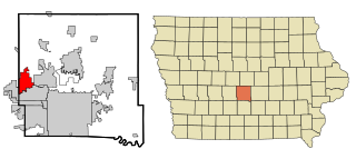
Polk County is located in the U.S. state of Iowa. As of the 2020 census, the population was 492,401. It is Iowa's most populous county, and home to over 15% of the state's residents. The county seat is Des Moines, which is also the capital city of Iowa. Polk County is included in the Des Moines–West Des Moines, IA Metropolitan Statistical Area.

<span class="mw-page-title-main">Jasper County, Iowa</span> County in Iowa, United States

Jasper County is a county in the U.S. state of Iowa. As of the 2020 census, the population was 37,813. The county seat is Newton. The county was organized in 1846 and is named after Sergeant William Jasper, a Revolutionary War hero.

<span class="mw-page-title-main">Dallas County, Iowa</span> County in Iowa, United States

Dallas County is a county located in the U.S. state of Iowa. As of the 2020 Census, the population was 99,678, making it the seventh-most populous county in Iowa. Between 2010 and 2020, it was the fastest growing county in Iowa and one of the fastest growing in the country. Its county seat is Adel, and its largest city is Waukee. The county was named for George M. Dallas, Vice President of the United States under James K. Polk, the namesake of neighboring Polk County.

<span class="mw-page-title-main">Sheldahl, Iowa</span> City in Iowa, United States

Sheldahl is a city in Polk, Boone, and Story counties in the U.S. state of Iowa. The population was 297 at the time of the 2020 census.

<span class="mw-page-title-main">Clive, Iowa</span> City in Iowa, United States

Clive is a city in Dallas and Polk counties in the U.S. state of Iowa. As of the 2020 Census, the population was 18,601. It is part of the Des Moines–West Des Moines Metropolitan Statistical Area. Clive is known for its Greenbelt Park and trail system running through the community. Clive serves as the axis of the western Des Moines suburbs, between Urbandale, Waukee and West Des Moines along the major transportation corridors of I-35, I-80 and I-235. The City of Urbandale is to the north to northwest, the City of West Des Moines is to the southeast to southwest, the City of Waukee in Dallas County is to the west.

<span class="mw-page-title-main">Granger, Iowa</span> City in Iowa, United States

Granger is a city in Dallas and Polk counties in the U.S. state of Iowa. The population was 1,654 at the time of the 2020 census, up 184% from 583 in 2000. It is part of the Des Moines–West Des Moines Metropolitan Statistical Area.

<span class="mw-page-title-main">Grimes, Iowa</span> City in Iowa, United States

Grimes is a city in Polk and Dallas counties in the U.S. state of Iowa. The population was 15,392 at the time of the 2020 Census. Grimes is part of the Des Moines-West Des Moines metropolitan area.

<span class="mw-page-title-main">Urbandale, Iowa</span> City in Iowa, United States

Urbandale is a city in Polk and Dallas counties, Iowa, United States. As of the 2020 U.S. Census, the city population was 45,580. It is part of the Des Moines–West Des Moines Metropolitan Statistical Area.

<span class="mw-page-title-main">Alleman, Iowa</span> City in Iowa, United States

Alleman is a city in Polk County, Iowa, United States. The population was 423 at the 2020 census. It is part of the Des Moines–West Des Moines Metropolitan Statistical Area.

<span class="mw-page-title-main">Altoona, Iowa</span> City in Iowa, United States

Altoona is a city in Polk County, Iowa, United States, and part of the Des Moines metropolitan area. The population was 19,565 at the 2020 census. It is home to the Adventureland amusement park and Prairie Meadows horse racing track and casino.

<span class="mw-page-title-main">Bondurant, Iowa</span> City in Iowa, United States

Bondurant is a city in Polk County, Iowa, United States. The population was 7,365 in the 2020 census, an increase of 90.8% from the 3,860 population in 2010. It is part of the Des Moines–West Des Moines metropolitan statistical area.

<span class="mw-page-title-main">Elkhart, Iowa</span> City in Iowa, United States

Elkhart is a city in Polk County, Iowa, United States. The population was 882 at the time of the 2020 census. It is part of the Des Moines–West Des Moines Metropolitan Statistical Area.

<span class="mw-page-title-main">Johnston, Iowa</span> City in Iowa, United States

Johnston is a city in Polk County, Iowa, United States. The population was 24,064 in the 2020 census, a large increase from the 8,649 population in 2000. It is part of the Des Moines–West Des Moines Metropolitan Statistical Area.

<span class="mw-page-title-main">Pleasant Hill, Iowa</span> City in Iowa, United States

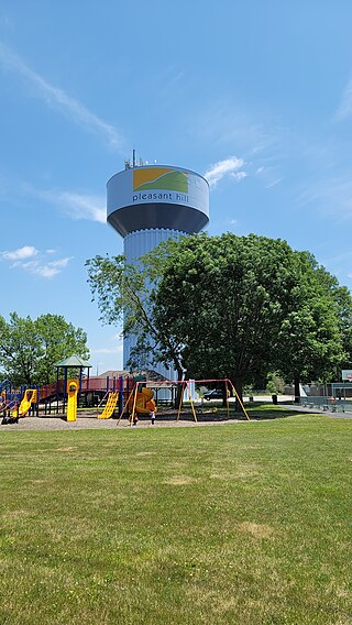
Pleasant Hill is a city in Polk County, Iowa, United States. The population was 10,147 at the time of the 2020 census. It is part of the Des Moines metropolitan area. As of July 2005, Pleasant Hill was assigned a ZIP code, 50327.

<span class="mw-page-title-main">Polk City, Iowa</span> City in Iowa, United States

Polk City is a city in Polk County, Iowa, United States. The population was 5543 in the 2020 census, an increase from 2,344 in 2000. It is part of the Des Moines–West Des Moines Metropolitan Statistical Area.

<span class="mw-page-title-main">Runnells, Iowa</span> City in Iowa, United States

Runnells is a city in the southeastern corner of Polk County, Iowa, United States. The population was 457 at the time of the 2020 census. It is part of the Des Moines–West Des Moines Metropolitan Statistical Area. Runnells has its own Post Office, located at 112 Brown Street.

<span class="mw-page-title-main">Saylorville, Iowa</span> CDP in Iowa, United States

Saylorville is a census-designated place (CDP) in Polk County, Iowa, United States. The population was 3,584 at the 2020 census. It is part of the Des Moines–West Des Moines Metropolitan Statistical Area. The Saydel Community School District is located in this area, as is the unincorporated community of Marquisville.

<span class="mw-page-title-main">Windsor Heights, Iowa</span> City in Iowa, United States

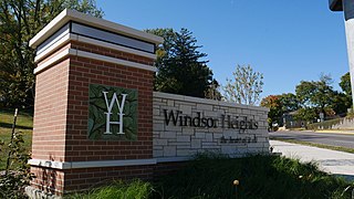
Windsor Heights is a city in Polk County, Iowa, United States. The population was 5,252 at the time of the 2020 census. It is part of the Des Moines–West Des Moines Metropolitan Statistical Area.

<span class="mw-page-title-main">Mitchellville, Tennessee</span> City in Tennessee, United States

Mitchellville is a city in Sumner County, Tennessee, United States. The population was 189 at the 2010 census, down from 207 in 2000.

<span class="mw-page-title-main">Carlisle, Iowa</span> City in Iowa, United States

Carlisle is a city in Warren and Polk counties in the U.S. state of Iowa. The population was 4,160 at the 2020 census. The city is part of the Des Moines–West Des Moines Metropolitan Statistical Area.

References

  1. "2020 U.S. Gazetteer Files". United States Census Bureau. Retrieved March 16, 2022.
  2. 1 2 U.S. Geological Survey Geographic Names Information System: Mitchellville, Iowa
  3. 1 2 "2020 Census State Redistricting Data". census.gov. United states Census Bureau. Retrieved August 12, 2021.
  4. Henning, Barbara Beving Long; Patrice K. Beam (2003). Des Moines and Polk County: Flag on the Prairie. Sun Valley, California: American Historical Press. ISBN   1-892724-34-0.
  5. [altoonahistory.org/uploads/ThomasMitchellarticleJuly2007.pdf]
  6. "US Gazetteer files 2010". United States Census Bureau. Archived from the original on January 25, 2012. Retrieved May 11, 2012.
  7. "Census of Population and Housing". Census.gov. Retrieved June 4, 2015.
  8. "U.S. Census website". United States Census Bureau . Retrieved May 11, 2012.
  9. "U.S. Census website". United States Census Bureau . Retrieved January 31, 2008.
  10. "Iowa Correctional Institution for Women Archived 2011-07-22 at the Wayback Machine ." Iowa Department of Corrections. Retrieved on November 29, 2010.
  11. Dicke, William (December 8, 1995). "Clair C. Patterson, Who Established Earth's Age, Is Dead at 73". The New York Times.
  12. Nemeh, Katherine H., ed. (2014). American Men & Women of Science: A Biographical Directory of Today’s Leaders in Physical, Biological and Related Sciences. Vol. 6 (32 ed.). Gale. p. 1393.