Lambs Grove, Iowa | |
---|---|
![]() Location of Lambs Grove, Iowa | |
Coordinates: 41°42′4″N93°4′42″W / 41.70111°N 93.07833°W | |
Country | ![]() |
State | ![]() |
County | Jasper |
Area | |
• Total | 0.10 sq mi (0.26 km2) |
• Land | 0.10 sq mi (0.26 km2) |
• Water | 0.00 sq mi (0.00 km2) |
Elevation | 919 ft (280 m) |
Population (2020) | |
• Total | 174 |
• Density | 1,705.88/sq mi (659.37/km2) |
Time zone | UTC-6 (Central (CST)) |
• Summer (DST) | UTC-5 (CDT) |
ZIP code | 50208 |
Area code | 641 |
FIPS code | 19-42870 |
GNIS feature ID | 0458212 |
Lambs Grove is a city in Jasper County, Iowa, United States. The population was 174 as of the 2020 Census, down from 225 recorded in 2000. [2]
Lambs Grove is located at 41°42′4″N93°4′42″W / 41.70111°N 93.07833°W (41.701199, -93.078282). [3]
According to the United States Census Bureau, the city has a total area of 0.10 square miles (0.26 km2), all land. [4] There is a small creek that flows through Lambs Grove. Hat Rock Park is located near the center of the town.
Lambs Grove was founded in 1927 by E. C. and Jennie Ogg and named after Richard Lamb, Jennie Ogg's father. [5] It was incorporated on December 29, 1952. [5]
On March 5, 2022, an EF4 tornado struck the town, although it was much weaker than it was earlier in its lifetime, damaging multiple homes and facilities. [6]
Year | Pop. | ±% |
---|---|---|
1960 | 234 | — |
1970 | 239 | +2.1% |
1980 | 228 | −4.6% |
1990 | 212 | −7.0% |
2000 | 225 | +6.1% |
2010 | 172 | −23.6% |
2020 | 174 | +1.2% |
Source: "U.S. Census website". United States Census Bureau . Retrieved March 29, 2020. and Iowa Data Center Source: |
As of the census [8] of 2010, there were 172 people, 73 households, and 52 families residing in the city. The population density was 1,720.0 inhabitants per square mile (664.1/km2). There were 80 housing units at an average density of 800.0 units per square mile (308.9 units/km2). The racial makeup of the city was 95.9% White, 2.9% from other races, and 1.2% from two or more races. Hispanic or Latino of any race were 2.9% of the population.
There were 73 households, of which 24.7% had children under the age of 18 living with them, 61.6% were married couples living together, 6.8% had a female householder with no husband present, 2.7% had a male householder with no wife present, and 28.8% were non-families. 26.0% of all households were made up of individuals, and 15.1% had someone living alone who was 65 years of age or older. The average household size was 2.36 and the average family size was 2.87.
The median age in the city was 47.5 years. 20.3% of residents were under the age of 18; 5.3% were between the ages of 18 and 24; 21% were from 25 to 44; 33.1% were from 45 to 64; and 20.3% were 65 years of age or older. The gender makeup of the city was 48.8% male and 51.2% female.
As of the census [9] of 2000, there were 225 people, 80 households, and 68 families residing in the city. The population density was 2,220.2 inhabitants per square mile (857.2/km2). There were 80 housing units at an average density of 789.4 units per square mile (304.8 units/km2). The racial makeup of the city was 97.78% White and 2.22% Asian. Hispanic or Latino of any race were 0.44% of the population.
There were 80 households, out of which 40.0% had children under the age of 18 living with them, 73.8% were married couples living together, 7.5% had a female householder with no husband present, and 15.0% were non-families. 12.5% of all households were made up of individuals, and 3.8% had someone living alone who was 65 years of age or older. The average household size was 2.81 and the average family size was 3.06.
In the city, the population was spread out, with 26.2% under the age of 18, 8.4% from 18 to 24, 23.1% from 25 to 44, 30.2% from 45 to 64, and 12.0% who were 65 years of age or older. The median age was 41 years. For every 100 females, there were 97.4 males. For every 100 females age 18 and over, there were 88.6 males.
The median income for a household in the city was $56,000, and the median income for a family was $65,417. Males had a median income of $45,000 versus $28,750 for females. The per capita income for the city was $20,923. About 6.2% of families and 5.6% of the population were below the poverty line, including 12.0% of those under the age of eighteen and none of those 65 or over.
Jasper County is a county in the U.S. state of Iowa. As of the 2020 census, the population was 37,813. The county seat is Newton. The county was organized in 1846 and is named after Sergeant William Jasper, a Revolutionary War hero.
Pleasant Grove is a city in western Jefferson County, Alabama, United States. It is part of the Birmingham metropolitan area. The population was 9,544 at the 2020 census.
Hazleton is a city in Buchanan County, Iowa, United States. The population was 713 at the time of the 2020 census.
Rockwell is a city in Cerro Gordo County, Iowa, United States. The population was 1,071 at the time of the 2020 census. It is part of the Mason City Micropolitan Statistical Area.
Lynnville is a city in Jasper County, Iowa, United States. The population was 380 at the time of the 2020 census.
Vincent is a city in Webster County, Iowa, United States. The population was 130 at the time of the 2020 census.
Mulberry is a city in Crawford County, Kansas, United States. As of the 2020 census, the population of the city was 409.
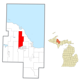
Ishpeming Township is a civil township of Marquette County in the U.S. state of Michigan. The population was 3,392 at the 2020 census. The city of Ishpeming is to the south, but the two are administered autonomously.
Calverton Park is a city in St. Louis County, Missouri, United States. The population was 1,293 at the 2010 census. The Village of Calverton Park incorporated as the City of Calverton Park in 2014.
Meire Grove is a city in Stearns County, Minnesota, United States. The population was 179 at the 2010 census. It is part of the St. Cloud Metropolitan Statistical Area.
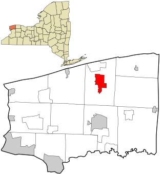
Oneida Castle is a village in Oneida County, New York, United States. The population was 625 at the 2010 census.
Bloom Township is a township in Clearfield County, Pennsylvania, United States. The population was 381 at the 2020 census.
Cooper Township is a township in Clearfield County, Pennsylvania, United States. The population was 2,593 at the 2020 census.
New Washington is a borough in Clearfield County, Pennsylvania, United States. The population was 50 at the 2020 census.
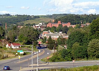
Mansfield is a borough located in east-central Tioga County, Pennsylvania, United States, in the Tioga River valley. It is situated at the intersection of U.S. Route 6 and U.S. Business Route 15, about 36 miles (58 km) southwest of Elmira, New York.
Cherry Grove Township is a township in Warren County, Pennsylvania, United States. The population at the 2020 census was 173, down from 216 in the 2010 census.
Fawn Grove is a borough in York County, Pennsylvania, United States. The population was 476 at the 2020 census. It is part of the York–Hanover metropolitan area. It is served by the South Eastern School District, which provides public education.
Lower Chanceford Township is a township in York County, Pennsylvania, United States. The population was 3,028 at the 2020 census.
Newfane is a census-designated place (CDP) in the town of Newfane in Niagara County, New York, United States, along State Route 78. The population was 3,822 at the 2010 census. It is part of the Buffalo–Niagara Falls Metropolitan Statistical Area.
Patch Grove is a village in Grant County, Wisconsin, United States. The population was 198 at the 2010 census. The village is located within the Town of Patch Grove.