Reasnor, Iowa

Last updated
Reasnor, Iowa
Jasper County Iowa Incorporated and Unincorporated areas Reasnor Highlighted.svg
Location of Reasnor, Iowa
Coordinates: 41°34′43″N93°1′22″W / 41.57861°N 93.02278°W / 41.57861; -93.02278 Coordinates: 41°34′43″N93°1′22″W / 41.57861°N 93.02278°W / 41.57861; -93.02278
Country Flag of the United States.svg  United States
State Flag of Iowa.svg  Iowa
County Jasper
Area
[1]
  Total0.56 sq mi (1.44 km2)
  Land0.56 sq mi (1.44 km2)
  Water0.00 sq mi (0.00 km2)
Elevation
764 ft (233 m)
Population
 (2020)
  Total152
  Density273.87/sq mi (105.68/km2)
Time zone UTC-6 (Central (CST))
  Summer (DST) UTC-5 (CDT)
ZIP code
50232
Area code 641
FIPS code 19-65955
GNIS feature ID0460545

Reasnor is a city in Jasper County, Iowa, United States. The population was 152 at the time of the 2020 census. [2]

Contents

History

Reasnor was platted in the summer of 1877, and named for its founders, Samuel and Mary Reasoner. [3] [4]

Geography

Reasnor is located at 41°34′43″N93°1′22″W / 41.57861°N 93.02278°W / 41.57861; -93.02278 (41.578495, -93.022814). [5]

According to the United States Census Bureau, the city has a total area of 0.55 square miles (1.42 km2), all land. [6]

Demographics

Historical populations
YearPop.±%
1920 226    
1930 229+1.3%
1940 221−3.5%
1950 227+2.7%
1960 224−1.3%
1970 284+26.8%
1980 277−2.5%
1990 191−31.0%
2000 194+1.6%
2010 152−21.6%
2020 152+0.0%
Source: "U.S. Census website". United States Census Bureau . Retrieved 2020-03-29. and Iowa Data Center
Source:
U.S. Decennial Census [7] [2]

2010 census

As of the census [8] of 2010, there were 152 people, 68 households, and 46 families living in the city. The population density was 276.4 inhabitants per square mile (106.7/km2). There were 78 housing units at an average density of 141.8 per square mile (54.7/km2). The racial makeup of the city was 99.3% White and 0.7% from other races. Hispanic or Latino of any race were 0.7% of the population.

There were 68 households, of which 26.5% had children under the age of 18 living with them, 48.5% were married couples living together, 17.6% had a female householder with no husband present, 1.5% had a male householder with no wife present, and 32.4% were non-families. 26.5% of all households were made up of individuals, and 14.7% had someone living alone who was 65 years of age or older. The average household size was 2.24 and the average family size was 2.63.

The median age in the city was 47 years. 20.4% of residents were under the age of 18; 5.3% were between the ages of 18 and 24; 22.3% were from 25 to 44; 28.9% were from 45 to 64; and 23% were 65 years of age or older. The gender makeup of the city was 48.7% male and 51.3% female.

2000 census

As of the census [9] of 2000, there were 194 people, 77 households, and 52 families living in the city. The population density was 388.5 inhabitants per square mile (150.0/km2). There were 80 housing units at an average density of 160.2 per square mile (61.9/km2). The racial makeup of the city was 98.97% White, and 1.03% from two or more races.

There were 77 households, out of which 29.9% had children under the age of 18 living with them, 61.0% were married couples living together, 3.9% had a female householder with no husband present, and 31.2% were non-families. 29.9% of all households were made up of individuals, and 14.3% had someone living alone who was 65 years of age or older. The average household size was 2.52 and the average family size was 3.09.

In the city, the population was spread out, with 27.3% under the age of 18, 6.2% from 18 to 24, 27.3% from 25 to 44, 23.2% from 45 to 64, and 16.0% who were 65 years of age or older. The median age was 37 years. For every 100 females, there were 102.1 males. For every 100 females age 18 and over, there were 98.6 males.

The median income for a household in the city was $37,500, and the median income for a family was $40,500. Males had a median income of $26,000 versus $20,417 for females. The per capita income for the city was $14,435. About 1.9% of families and 4.2% of the population were below the poverty line, including 4.9% of those under the age of eighteen and 10.0% of those 65 or over.

Education

The PCM Community School District operates public schools serving the community. [10] This district was formed on July 1, 1991 by a merger of the Prairie City and Monroe school districts. [11] Residents are zoned to PCM Middle School in Prairie City and PCM Community High School in Monroe. [12]

Related Research Articles

<span class="mw-page-title-main">Jasper County, Iowa</span> County in Iowa, United States

Jasper County is a county in the U.S. state of Iowa. As of the 2020 census, the population was 37,813. The county seat is Newton. The county was organized in 1846 and is named after Sergeant William Jasper, a Revolutionary War hero.

<span class="mw-page-title-main">Clarke County, Iowa</span> County in Iowa, United States

Clarke County is a county located in the U.S. state of Iowa. As of the 2020 census, the population was 9,748. The county seat is Osceola. The county was formed in January 1846, one of twelve counties established by legislative action in a comprehensive act. It was named for James Clarke, a Governor of the Iowa Territory.

<span class="mw-page-title-main">Baxter, Iowa</span> City in Iowa, United States

Baxter is a city in Jasper County, Iowa, United States. Baxter is located 33 miles (53 km) northeast of Des Moines. The population was 962 at the 2020 census.

<span class="mw-page-title-main">Colfax, Iowa</span> City in Iowa, USA

Colfax is a city in Jasper County, Iowa, United States. Colfax is located approximately 24 miles east of Des Moines. The town was founded in 1866, and was named after Schuyler Colfax, vice president under Ulysses S. Grant. The population was 2,255 at the time of the 2020 census. Newton is the county seat; both were named after Revolutionary War soldiers.

<span class="mw-page-title-main">Kellogg, Iowa</span> City in Iowa, United States

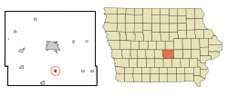
Kellogg is a city in Jasper County, Iowa, United States. The population was 606 at the time of the 2020 census. It was originally named Manning's Station, then carried the names Jasper City, Kimball, and then finally Kellogg, named for the pioneer settler Judge Abel Avery Kellogg.

<span class="mw-page-title-main">Lambs Grove, Iowa</span> City in Iowa, United States

Lambs Grove is a city in Jasper County, Iowa, United States. The population was 174 as of the 2020 Census, down from 225 recorded in 2000.

<span class="mw-page-title-main">Lynnville, Iowa</span> City in Iowa, United States

Lynnville is a city in Jasper County, Iowa, United States. The population was 380 at the time of the 2020 census.

<span class="mw-page-title-main">Mingo, Iowa</span> City in Iowa, United States

Mingo is a city in Jasper County, Iowa, United States. The population was 302 at the time of the 2020 census.

<span class="mw-page-title-main">Monroe, Iowa</span> City in Iowa, United States

Monroe is a city in Jasper and Marion counties in Iowa, United States. The population was 1,967 at the time of the 2020 census.

<span class="mw-page-title-main">Oakland Acres, Iowa</span> City in Iowa, United States

Oakland Acres is a city in Jasper County, Iowa, United States. The population was 176 at the time of the 2020 census.

<span class="mw-page-title-main">Prairie City, Iowa</span> City in Iowa, United States

Prairie City is a city in Jasper County, Iowa, United States. The population was 1,700 at the time of the 2020 census. It is twenty-two miles east of Des Moines.

<span class="mw-page-title-main">Sully, Iowa</span> City in Iowa, United States

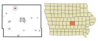
Sully is a city located in Jasper County, Iowa, United States, named after railroad man Alfred Sully. The population was 881 at the time of the 2020 census.

<span class="mw-page-title-main">Valeria, Iowa</span> City in Iowa, United States

Valeria is a city in Jasper County, Iowa, United States. The population was 39 at the time of the 2020 census.

<span class="mw-page-title-main">Sterling, Michigan</span> Village in Michigan, United States

Sterling is a village in Arenac County in the U.S. state of Michigan. The population was 530 at the 2010 census. The village is located within Deep River Township.

<span class="mw-page-title-main">Stanwood, Michigan</span> Village in Michigan, United States

Stanwood is a village in Mecosta County of the U.S. state of Michigan. The population was 211 at the 2010 census. The village is within Mecosta Township.

<span class="mw-page-title-main">South Lineville, Missouri</span> Village in Missouri, United States

South Lineville is a village in Mercer County, Missouri, United States. The population was 13 at the 2020 census, a decline of fifteen people from the 2010 census.

<span class="mw-page-title-main">Steele City, Nebraska</span> Village in Nebraska, United States

Steele City is a village in Jefferson County, Nebraska, United States. The population was 47 at the 2020 census.

<span class="mw-page-title-main">Northville, South Dakota</span> Town in South Dakota, United States

Northville is a town in Spink County, South Dakota, United States. The population was 139 at the 2020 census.

<span class="mw-page-title-main">Wilson, Eau Claire County, Wisconsin</span> Town in Wisconsin, United States

Wilson is a town in Eau Claire County, Wisconsin, United States. The population was 485 at the 2010 census. The unincorporated community of Wilson is located in the town.

<span class="mw-page-title-main">Mitchellville, Iowa</span> City in Iowa, United States

Mitchellville is a city located in Polk and Jasper counties in the U.S. state of Iowa. The population was 2,485 at the time of the 2020 census.

References

  1. "2020 U.S. Gazetteer Files". United States Census Bureau. Retrieved March 16, 2022.
  2. 1 2 "2020 Census State Redistricting Data". census.gov. United states Census Bureau. Retrieved 12 August 2021.
  3. Weaver, James Baird (1912). Past and Present of Jasper County, Iowa, Volume 1. B.F. Bowen. p. 361.
  4. The History of Jasper County, Iowa, Containing a History of the County, Its Cities, Towns, &c. Western Historical. 1878. p. 505.
  5. "US Gazetteer files: 2010, 2000, and 1990". United States Census Bureau. 2011-02-12. Retrieved 2011-04-23.
  6. "US Gazetteer files 2010". United States Census Bureau. Archived from the original on 2012-01-25. Retrieved 2012-05-11.
  7. "Census of Population and Housing". Census.gov. Retrieved June 4, 2015.
  8. "U.S. Census website". United States Census Bureau . Retrieved 2012-05-11.
  9. "U.S. Census website". United States Census Bureau . Retrieved 2008-01-31.
  10. "PCM." Iowa Department of Education. Retrieved on July 17, 2018.
  11. "REORGANIZATION & DISSOLUTION ACTIONS SINCE 1965-66." Iowa Department of Education. Retrieved on July 20, 2018.
  12. "Home." PCM Community School District. Retrieved on July 17, 2018.