Pointe-Verte, New Brunswick

Last updated

Pointe-Verte
Former Village
Canada New Brunswick location map 2.svg
Red pog.svg

Pointe-Verte
Location within New Brunswick.
Coordinates: 47°51′N65°46′W / 47.850°N 65.767°W / 47.850; -65.767
CountryCanada
Province New Brunswick
County Gloucester
Parish Beresford
Town Belle-Baie
Village1966
Area
[1]
  Land13.76 km2 (5.31 sq mi)
Elevation
11 m (36 ft)
Population
 (2021) [1]
  Total865
  Density62.9/km2 (163/sq mi)
  Change 2016–21
Decrease2.svg 2.4%
  Dwellings
433
Time zone UTC-4 (AST)
  Summer (DST) UTC-3 (ADT)
Postal code
E8J
Area code 506
HighwaysNB 134.svg Route 134 NB 11.svg Route 11
Website www.pointe-verte.ca

Pointe-Verte is a community and former village in Gloucester County, New Brunswick. It held village status prior to 2023 and is now part of the Town of Belle-Baie.

Contents

History

On January 1, 2023, Pointe-Verte amalgamated with Beresford, Nigadoo, Petit-Rocher, and all or part of ten local service districts to form the new town of Belle-Baie. [2] [3] The community's name remains in official use. [4]

Geography

Located on Chaleur Bay 30 km north of Bathurst, the village's main industry is lobster and scallop fishing, as well as forestry.

Demographics

Historical Census Data - Pointe-Verte, New Brunswick [5]
YearPop.±%
19961,122    
20011,041−7.2%
2006971−6.7%
2011976+0.5%
2016886−9.2%
2021865−2.4%
Source: [1]

In the 2021 Census of Population conducted by Statistics Canada, Pointe-Verte had a population of 865 living in 400 of its 433 total private dwellings, a change of

Canada census – Pointe-Verte community profile
2021 2016 2011
Population865 (-2.4% from 2016)886 (-9.2% from 2011)976 (+0.5% from 2006)
Land area13.76 km2 (5.31 sq mi)13.76 km2 (5.31 sq mi)13.79 km2 (5.32 sq mi)
Population density62.9/km2 (163/sq mi)64.4/km2 (167/sq mi)70.8/km2 (183/sq mi)
Median age58 (M: 57.2, F: 58)54.8 (M: 54.4, F: 55.1)51.8 (M: 51.9, F: 51.6)
Total private dwellings400410464
Median household income$55,168$57,766
References: 2021 [6] 2016 [7] 2011 [8] earlier [9] [10]

Language

Canada Census Mother Tongue - Pointe-Verte, New Brunswick [5]
CensusTotal
French
English
French & English
Other
YearResponsesCountTrendPop %CountTrendPop %CountTrendPop %CountTrendPop %
2021
845
720Decrease2.svg 8.28%85.21%115Increase2.svg 35.29%13.61%5Decrease2.svg 66.66%0.59%5Steady2.svg 0.0%0.05%
2016
885
785Decrease2.svg 9.24%88.70%85Increase2.svg 6.25%9.6%15Increase2.svg 50.0%1.69%5Increase2.svg 0.0%0.5%
2011
955
865Decrease2.svg 2.8%90.57%80Increase2.svg 45.5%8.38%10Steady2.svg 0.0%1.05%0Steady2.svg 0.0%0.00%
2006
955
890Decrease2.svg 6.8%93.19%55Decrease2.svg 26.7%5.76%10Steady2.svg 0.0%1.05%0Steady2.svg 0.0%0.00%
2001
1,040
955Decrease2.svg 11.2%91.83%75Increase2.svg 66.7%7.21%10Increase2.svg n/a%0.96%0Steady2.svg 0.0%0.00%
1996
1,120
1,075n/a95.98%45n/a4.02%0n/a0.00%0n/a0.00%

Notable people

See also

Related Research Articles

Beresford was a town in Gloucester County, New Brunswick. It held town status prior to 2023 and is now part of the town of Belle-Baie as a result of amalgamation.

<span class="mw-page-title-main">Beresford Parish, New Brunswick</span> Parish in New Brunswick, Canada

Beresford is a civil parish in Gloucester County, New Brunswick, Canada.

Dalhousie is a former town located in Northern New Brunswick. On January 1, 2023, Dalhousie merged with the village of Charlo and all or part of five local service districts (LSDs) to form the new town of Heron Bay, named Baie-des-Hérons in French. Heron Bay is New Brunswick's northernmost point of land.

<span class="mw-page-title-main">Petit-Rocher, New Brunswick</span> Community in New Brunswick, Canada

Petit-Rocher is a former village in Gloucester County, New Brunswick. It held village status prior to 2023 and is now part of the town of Belle-Baie. Sitting on the western shore of both Chaleur Bay and Nepisiguit Bay 20 km northwest of Bathurst.

<span class="mw-page-title-main">Bas-Caraquet, New Brunswick</span> Place in New Brunswick, Canada

Bas-Caraquet is a former village in Gloucester County, New Brunswick, Canada. It held village status prior to 2023 and is now part of the town of Caraquet.

<span class="mw-page-title-main">Nigadoo</span> Community in New Brunswick, Canada

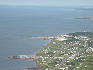
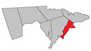
Nigadoo is a community and former village in Gloucester County, New Brunswick. It held village status prior to 2023 and is now part of the town of Belle-Baie. Nigadoo is located at the mouth of the Nigadoo River on Nepisiguit Bay, 15 km northwest of Bathurst and adjacent to Beresford.

<span class="mw-page-title-main">Paquetville</span> Place in New Brunswick, Canada

Paquetville is a former village in Gloucester County, New Brunswick, Canada. It held village status prior to 2023 and is now part of the town of Hautes-Terres. It is on the Acadian Peninsula at the intersection of Route 340, Route 135 and Route 350.

Port Elgin is a former Canadian village in Westmorland County, New Brunswick. It is located near the Nova Scotia border at the mouth of the Gaspereaux River where it empties into the Northumberland Strait's Baie Verte and is now part of the rural community of Strait Shores.

<span class="mw-page-title-main">Rivière-Verte, New Brunswick</span> Neighbourhood in Madawaska, New Brunswick, Canada

Rivière-Verte is a neighbourhood in Edmundston. It held village status prior to 2023.

<span class="mw-page-title-main">Colborne Parish, New Brunswick</span> Parish in New Brunswick, Canada

Colborne is a civil parish in Restigouche County, New Brunswick, Canada.

<span class="mw-page-title-main">Durham Parish, New Brunswick</span> Parish in New Brunswick, Canada

Durham is a civil parish in Restigouche County, New Brunswick, Canada.

<span class="mw-page-title-main">Bathurst Parish, New Brunswick</span> Parish in New Brunswick, Canada

Bathurst is a civil parish in Gloucester County, New Brunswick, Canada.

<span class="mw-page-title-main">Caraquet Parish, New Brunswick</span> Parish in New Brunswick, Canada

Caraquet is a civil parish in Gloucester County, New Brunswick, Canada.

<span class="mw-page-title-main">Shippegan Parish, New Brunswick</span> Parish in New Brunswick, Canada

Shippegan is a civil parish in Gloucester County, New Brunswick, Canada. Located in the northeastern corner of the province at the end of the Acadian Peninsula, the parish consists of the three main islands of Taylor, Lamèque, and Miscou, along with several smaller islands and tidal wetlands; Taylor Island is now joined to the mainland by an isthmus, which is crossed by a causeway.

<span class="mw-page-title-main">Allardville Parish, New Brunswick</span> Parish in New Brunswick, Canada

Allardville is a civil parish in Gloucester County, New Brunswick, Canada,

<span class="mw-page-title-main">Caraquet</span> Town in New Brunswick, Canada

Caraquet is a town in Gloucester County, New Brunswick, Canada.

<span class="mw-page-title-main">Westmorland Parish, New Brunswick</span> Parish in New Brunswick, Canada

Westmorland is a civil parish in Westmorland County, New Brunswick, Canada.

Daniel Guitard is a Canadian politician who has been serving as the first mayor of Belle-Baie since 2023. Previously, he was the Speaker of the Legislative Assembly of New Brunswick. He was first elected to the Legislative Assembly of New Brunswick in the 2014 provincial election. He represented the electoral district of Restigouche-Chaleur as a member of the Liberal Party. On October 23, 2018, members of the assembly selected Guitard to serve as Speaker of the Legislative Assembly of New Brunswick. On October 11, 2022, he announced his resignation due to his plans to run for mayor of the newly-created municipality of Belle-Baie. He would end up being successful. He was previously mayor of Pointe-Verte, New Brunswick.

<span class="mw-page-title-main">Belle-Baie</span> Town in New Brunswick, Canada

Belle-Baie is a town in the Canadian province of New Brunswick. It was formed through the 2023 New Brunswick local governance reforms.

References

  1. 1 2 3 4 "Census Profile of Pointe-Verte, Village (VL)". Statistics Canada. December 6, 2022. Retrieved January 21, 2023.
  2. "Local Governments Establishment Regulation – Local Governance Act". Government of New Brunswick. October 12, 2022. Retrieved January 21, 2023.
  3. "RSC 3 Chaleur Regional Service Commission". Government of New Brunswick. Retrieved January 21, 2023.
  4. "Proposed entity names reflect strong ties to nature and history" (Press release). Irishtown, New Brunswick: Government of New Brunswick. May 25, 2022. Retrieved January 21, 2023.
  5. 1 2 Statistics Canada: 1996, 2001, 2006, 2011 census
  6. "2021 Community Profiles". 2021 Canadian Census . Statistics Canada. February 4, 2022. Retrieved April 27, 2022.
  7. "2016 Community Profiles". 2016 Canadian Census . Statistics Canada. August 12, 2021. Retrieved November 19, 2018.
  8. "2011 Community Profiles". 2011 Canadian Census . Statistics Canada. March 21, 2019. Retrieved April 2, 2014.
  9. "2006 Community Profiles". 2006 Canadian Census . Statistics Canada. August 20, 2019.
  10. "2001 Community Profiles". 2001 Canadian Census . Statistics Canada. July 18, 2021.

47°51′N65°46′W / 47.850°N 65.767°W / 47.850; -65.767 (Pointe-Verte)