Related Research Articles

The Crow, whose autonym is Apsáalooke, also spelled Absaroka, are Native Americans living primarily in southern Montana. Today, the Crow people have a federally recognized tribe, the Crow Tribe of Montana, with an Indian reservation, the Crow Indian Reservation, located in the south-central part of the state.
Knox County is a county in the U.S. state of Nebraska. As of the 2020 United States Census, the population was 8,391. Its county seat is Center. Knox County was named for Continental and U.S. Army Major General Henry Knox.

Cherry County is a county located in the U.S. state of Nebraska. As of the 2020 United States Census, the population was 5,455. Its county seat is Valentine. The county was named for Lt. Samuel A. Cherry, an Army officer who was stationed at Fort Niobrara and who had been killed in South Dakota in 1881. Cherry County is in the Nebraska Sandhills. It is the largest county in the state at nearly 6,000 square miles (16,000 km2), larger than the state of Connecticut.

The Niobrara River is a tributary of the Missouri River, approximately 568 miles (914 km) long, running through the U.S. states of Wyoming and Nebraska. The river drains one of the most arid sections of the Great Plains, and has a low flow for a river of its length. The Niobrara's watershed includes the northern tier of Nebraska Sandhills, a small south-central section of South Dakota, as well as a small area of eastern Wyoming.

Arikara, also known as Sahnish, Arikaree, Ree, or Hundi, are a tribe of Native Americans in North Dakota. Today, they are enrolled with the Mandan and the Hidatsa as the federally recognized tribe known as the Mandan, Hidatsa, and Arikara Nation.

The Ponca people are a nation primarily located in the Great Plains of North America that share a common Ponca culture, history, and language, identified with two Indigenous nations: the Ponca Tribe of Indians of Oklahoma or the Ponca Tribe of Nebraska.
This nation comprised the modern-day Ponca, Omaha, Kaw, Osage, and Quapaw peoples until the mid-17th century when the people sought to establish their nation west of the Mississippi River as a result of the Beaver Wars. By the end of the 18th century, the Ponca people had established themselves at the mouth of the Niobrara River near its confluence with the Missouri River, remaining there until 1877 when the United States forcibly removed the Ponca people from the Ponca Reservation in the Dakota Territory to the Indian Territory. This event, known as the Ponca Trail of Tears, resulted in the deaths of hundreds of Ponca civilians and the splintering of the nation. In 1879, two years after the removal, a small portion of the Ponca elected to return to Nebraska in 1879. This group, led by Standing Bear, ultimately gave rise to the present-day Ponca Tribe of Nebraska. Two years later, the majority of the Ponca were given the opportunity to return to Nebraska but elected against doing so, having established themselves on a new reservation in the Indian Territory. This group, led by White Eagle, ultimately gave rise to the Ponca Tribe of Oklahoma.

Standing Bear was a Ponca chief and Native American civil rights leader who successfully argued in U.S. District Court in 1879 in Omaha that Native Americans are "persons within the meaning of the law" and have the right of habeas corpus, thus becoming the first Native American judicially granted civil rights under American law. His first wife Zazette Primeau (Primo), daughter of Lone Chief, mother of Prairie Flower and Bear Shield, was also a signatory on the 1879 writ that initiated the famous court case.
The Omaha are a federally recognized Midwestern Native American tribe who reside on the Omaha Reservation in northeastern Nebraska and western Iowa, United States. There were 5,427 enrolled members as of 2012. The Omaha Reservation lies primarily in the southern part of Thurston County and northeastern Cuming County, Nebraska, but small parts extend into the northeast corner of Burt County and across the Missouri River into Monona County, Iowa. Its total land area is 307.03 sq mi (795.2 km2) and the reservation population, including non-Native residents, was 4,526 in the 2020 census. Its largest community is Pender.

Lewis and Clark Lake is a 31,400 acre (130 km²) reservoir located on the border of the U.S. states of Nebraska and South Dakota on the Missouri River. The lake is approximately 25 miles (40 km) in length with over 90 miles (140 km) of shoreline and a maximum water depth of 45 feet (14 m). The lake is impounded by Gavins Point Dam and is managed by the U.S. Army Corps of Engineers, Omaha District.
The Missouri National Recreational River is a National Recreational River located on the border between Nebraska and South Dakota. The designation was first applied in 1978 to a 59-mile section of the Missouri River between Gavins Point Dam and Ponca State Park. In 1991, an additional 39-mile section between Fort Randall Dam and Niobrara, Nebraska, was added to the designation. These two stretches of the Missouri River are the only parts of the river between Montana and the mouth of the Missouri that remain undammed or unchannelized. The last 20 miles of the Niobrara River and 6 miles of Verdigre Creek were also added in 1991.

The Ponca Tribe of Nebraska is one of two federally recognized tribes of the Ponca people. The other is the Ponca Tribe of Indians of Oklahoma.
The Ponca are a Native American tribe.

Native American tribes in the U.S. state of Nebraska have been Plains Indians, descendants of succeeding cultures of indigenous peoples who have occupied the area for thousands of years. More than 15 historic tribes have been identified as having lived in, hunted in, or otherwise occupied territory within the current state boundaries.
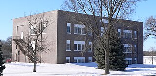
The Niobrara Reservation is a former Indian Reservation in northeast Nebraska. It originally comprised lands for both the Santee Sioux and the Ponca, both Siouan-speaking tribes, near the mouth of the Niobrara River at its confluence with the Missouri River. In the late nineteenth century the United States government built a boarding school at the reservation for the Native American children in the region. By 1908 after allotment of plots to individual households of the tribes under the Dawes Act, 1,130.7 acres (4.576 km2) were reserved for an agency, school and mission for a distinct Santee Sioux Reservation; the neighboring Ponca Reservation had only 160 acres (0.65 km2) reserved for agency and school buildings.
The Ponca Reservation of the Ponca Tribe of Nebraska is located in northeast Nebraska, with the seat of tribal government located in Niobrara, Knox County. The Indian reservation is also the location of the historic Ponca Fort called Nanza. The Ponca tribe does not actually have a reservation because the state of Nebraska will not allow them to have one. However, they do in fact have a 15-county service delivery area, including counties spread throughout Nebraska, South Dakota and Iowa.
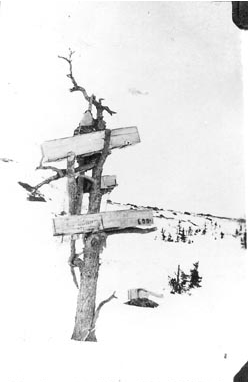
A burial tree or burial scaffold is a tree or simple structure used for supporting corpses or coffins. They were once common among the balinese, the Naga people, certain Aboriginal Australians, and some North American First Nations.
The Biesterfeldt Site is an archaeological site near Lisbon, North Dakota, United States, located along the Sheyenne River. The site is the only documented village of earth lodges in the watershed of the Red River, and the only one that has been unambiguously affiliated with the Cheyenne tribe. An independent group of Cheyennes is believed to have occupied it c. 1724–1780. In 1980, the site was listed on the National Register of Historic Places because of its archaeological significance. It was designated a National Historic Landmark in 2016.
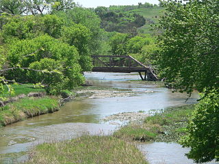
Ponca Creek is a stream that flows from southern South Dakota and into northern Nebraska. It is 139 miles (224 km) long. Its source is about 4 miles (6.4 km) west of U.S. 183, near Colome. It flows into the Missouri River 6 miles (9.7 km) northwest of Niobrara. Ponca Creek starts out going east, then takes a southeast direction, which continues until around Bristow, Nebraska, where it turns east again until it flows into the Missouri River. The entire Ponca Creek watershed drains 520,000 acres (2,100 km2). The watershed stretches from central Tripp County to central Gregory County.
The Dhegihan migration and separation was the long journey on foot by the North American Indians in the ancient Hą́ke tribe. During the migration from present-day Illinois/Kentucky and as far as Nebraska, they gradually split up into five groups. Each became an independent and historic tribe. They are the Omaha, Ponca, Kaw or Kansa, Osage and Quapaw.
References
- ↑ Dorsey, J. (1884) Omaha sociology. Bureau of American Ethnology Annual Report. Washington, DC: Smithsonian Institution
- ↑ Howard, J. (1965). The Ponca Tribe. Bureau of American Ethnology. Washington, DC: Smithsonian Institution.
- ↑ (n.d.)Nebraska National Register Sites in Knox County. [usurped] Nebraska State Historical Society.
- ↑ Johansen, B. (Ed.) (2004) Enduring legacies: Native American treaties and contemporary controversies. Praeger/Greenwood.
- ↑ National Register in Knox County - Nebraska
42°48′29″N98°09′49″W / 42.8081°N 98.1636°W
| Historic and present tribes | |
|---|---|
| Present languages | |
| Present reservations | |
| Present tribal colleges and universities | |
| Historic figures | |
| Historic events | |
| Historic reservations | |
| Historic communities | |
| Historic sacred places | |
| Other historic places | |
| Precontact peoples | |
| Precontact communities |
|
| Other precontact places |
|
| Other topics | |
| Topics | |
|---|---|
| Lists by state |
|
| Lists by insular areas | |
| Lists by associated state | |
| Other areas | |
| Related | |
| | This Knox County, Nebraska state location article is a stub. You can help Wikipedia by expanding it. |
| | This article relating to the history of the United States is a stub. You can help Wikipedia by expanding it. |