
The Eastern Cape is one of the provinces of South Africa. Its capital is Bhisho, but its two largest cities are East London and Gqeberha.
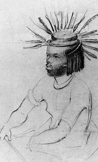
The Mpondo People or simply AmaMpondo, is one of the kingdoms in what is now the Eastern Cape. Having been established way back in the year 1228. The AmaMpondo Nation were first ruled by its founder who was King Mpondo kaNjanya who lived around (1205-1280) and later the 'AmaNyawuza'clan, by nationality referred to themselves as 'AmaMpondo'. They are related to other AbaMbo kingdoms and chiefdoms in South Africa.

The Maputaland-Pondoland bushland and thickets is one of the ecoregions of South Africa. It consists of the montane shrubland biome.

The Kwazulu-Cape coastal forest mosaic is a subtropical moist broadleaf forest ecoregion of South Africa. It covers an area of 17,800 square kilometers (6,900 sq mi) in South Africa's Eastern Cape and KwaZulu-Natal provinces.
King Botha Sigcau was a King in Eastern Pondoland, Transkei, South Africa (1939–1976) and later the figurehead President of Transkei from 1976 to 1978. A graduate of University of Fort Hare, Sigcau was an early supporter of the Bantu Authorities in Transkei and was rewarded by the South African government when he was appointed chairman of the Transkei Territorial Authority, the parliament before independence.

The Wild Coast is a section of the coast of the Eastern Cape, a province of South Africa. The region stretches from East London in the south to the border of KwaZulu-Natal in the north. It is the traditional home of the Mpondo people, and the birthplace of many prominent South Africans, including Nelson Mandela and Thabo Mbeki.

The Maputaland-Pondoland-Albany Hotspot (MPA) is a biodiversity hotspot, a biogeographic region with significant levels of biodiversity, in Southern Africa. It is situated near the south-eastern coast of Africa, occupying an area between the Great Escarpment and the Indian Ocean. The area is named after Maputaland, Pondoland and Albany. It stretches from the Albany Centre of Plant Endemism in the Eastern Cape Province of South Africa, through the Pondoland Centre of Plant Endemism and KwaZulu-Natal Province, the eastern side of Eswatini and into southern Mozambique and Mpumalanga. The Maputaland Centre of Plant Endemism is contained in northern KwaZulu-Natal and southern Mozambique.

Maputaland is a natural region of Southern Africa. It is located in the northern part of the province of KwaZulu-Natal, South Africa between Eswatini and the coast. In a wider sense it may also include the southernmost region of Mozambique. The bird routes and coral reefs off the coast are major tourist attractions.
The Gcaleka House is the Great house of the Xhosa Kingdom in what is now the Eastern Cape. Its royal palace is in the former Transkei and its counterpart in the former Ciskei is the Rharhabe, which is the right hand house of Phalo.
Port St. Johns Local Municipality is an administrative area in the OR Tambo District of Eastern Cape in South Africa.

Port St. Johns is a town of about 6,500 people on the Wild Coast in the Eastern Cape province of South Africa. It is situated at the mouth of the Umzimvubu River, 220 kilometres (140 mi) northeast of East London and 70 kilometres (40 mi) east of Mthatha. Port St. Johns was the Birthplace of Capital Radio 604.

Lusikisiki is a town in the Ingquza Hill Local Municipality in the Eastern Cape Province, South Africa. The name is onomatopoeic, derived from the rustling sound of reeds in the wind, named by the local Xhosa people. Lusikisiki is 45 kilometers inland from and north of Port St Johns. The town is positioned along the R61 leading to Mthatha to the west and Durban to the north-east.

Thembuland, Afrikaans: Temboeland, is a natural region in the Eastern Cape province of South Africa. Its territory is the traditional region of the abaThembu, one of the states of the Xhosa nation.
According to their own tradition, the Bomvana originate from the Amangwane, a people from Kwa-Zulu Natal. The AmaBomvana are descended from Nomafu, the first of the AmaNgwana tribe and from Bomvu, who gave rise to the AmaBomvu tribe. Bomvu's Great Son, Nyonemnyam, carried on the Bomvu dynasty. His son Njilo is the progenitor of the AmaBomvana. The AmaBomvana people left Natal in 1650 to settle in Pondoland after a dispute over cattle. After the death of Njilo’s wife, their grandson Dibandlela refused to send, in accordance with custom, the isizi cattle to his grandfather. This led to an open dispute. Dibandlela fled with his supporters and their cattle to settle in Pondoland
The Albany Centre of Plant Endemism is situated in the coastal region of South Africa at the eastern end of the Eastern Cape Province. It is named after the district of Albany and falls within the Maputaland-Pondoland-Albany Hotspot. It is notable for its biodiversity and unique, endemic flora and fauna.
The Indian Ocean coastal belt is one of the nine recognised biomes of South Africa. They are described in terms of their vegetation and climatic variations.
The Biodiversity of South Africa is the variety of living organisms within the boundaries of South Africa and its exclusive economic zone. South Africa is a region of high biodiversity in the terrestrial and marine realms. The country is ranked sixth out of the world's seventeen megadiverse countries, and is rated among the top 10 for plant species diversity and third for marine endemism.
The Mpondomise people, also called AmaMpondomise, are a Xhosa-speaking people. Their traditional homeland has been in the contemporary era Eastern Cape province of South Africa, during apartheid they were located both in the Ciskei and Transkei region. Like other separate Xhosa-speaking kingdoms such as abaThembu and amaMpondo, they speak Xhosa and are at times considered as part of the Xhosa people.


