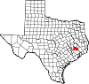
Montgomery County is a county in the U.S. state of Texas. As of the 2020 U.S. census, the county had a population of 620,443. The county seat is Conroe. The county was created by an act of the Congress of the Republic of Texas on December 14, 1837, and is named for the town of Montgomery. Between 2000 and 2010, its population grew by 55%, the 24th-fastest rate of growth of any county in the United States. Between 2010 and 2020, its population grew by 36%. According to the U.S. Census Bureau, the estimated population is 711,354 as of July 1, 2023.

Circle D-KC Estates is a census-designated place (CDP) in Bastrop County, Texas, United States. The population was 2,588 at the 2020 census.
Wyldwood is a census-designated place (CDP) in Bastrop County, Texas, United States. The population was 3,694 at the 2020 census.

Balcones Heights is a city in Bexar County, Texas, United States. Its population was 2,746 at the 2020 census, and it was incorporated in 1948. Balcones Heights is an enclave of San Antonio, surrounded entirely by the city, thus some residents and out-of-town visitors erroneously consider it merely a neighborhood of the larger city rather than its own unique community that did so to prevent annexation.

Homestead Meadows North is a census-designated place (CDP) in El Paso County, Texas, United States. The population was 5,124 at the 2010 census. It is part of the El Paso Metropolitan Statistical Area. The ZIP Code encompassing the CDP area is 79938.

Channelview is a census-designated place (CDP) in the U.S. state of Texas on the east side of Houston in Harris County. Its population was 45,688 at the 2020 U.S. census.

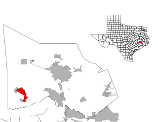
Cut and Shoot is a city in eastern Montgomery County, Texas, United States, about 6 mi (9.7 km) east of Conroe and 40 mi (64 km) north of Houston. Until 2006, Cut and Shoot was considered and called a town. Then, the town council elected for it to be considered and referred to as a city. The population was 1,087 at the 2020 census.
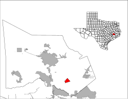
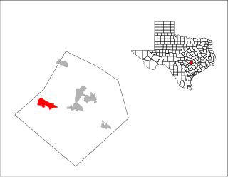
Pinehurst is a census-designated place (CDP) in Montgomery County, Texas, United States. The population was 5,195 at the 2020 census.

Roman Forest is a city in Montgomery County, Texas, United States. The population was 1,781 at the 2020 census.

Shenandoah is a city in Montgomery County, Texas, United States. Its population was 3,499 at the 2020 census. It is the hometown of David Vetter, the famous "boy in the plastic bubble". In 1986, the Shenandoah city council renamed Tamina School Road to David Memorial Drive in honor of Vetter.

Woodbranch Village, also known simply as "Woodbranch," is a city in Montgomery County, Texas, United States. The population was 1,330 at the 2020 census.

Falcon Heights is a census-designated place (CDP) in Starr County, Texas, United States. The population was 18 at the 2020 census, down from 53 at the 2010 census.

Fronton is a census-designated place (CDP) in Starr County, Texas, United States, bordering the Mexican state of Tamaulipas, close to Ciudad Miguel Alemán. The population was 172 at the 2020 census, a decline from the figure of 180 tabulated in 2010.

North Escobares is a census-designated place (CDP) in Starr County, Texas, United States. The population was 118 at the 2010 census, a decline from the figure of 1,692 tablulated in 2000.
Brushy Creek is a census-designated place (CDP) in Williamson County, Texas, United States. The population was 22,519 at the 2020 census.

Conroe Independent School District (CISD) is a school district in Montgomery County, Texas. The current superintendent has been Dr. Curtis Null since June of 2018. As of April 2024, Conroe ISD was the 9th largest school district in Texas and 60th largest in the United States.

Caney Creek High School is a high school in Montgomery County, Texas, near Conroe. It is part of the Conroe Independent School District. Caney Creek serves several areas in Montgomery County, including the city of Cut and Shoot, the census-designated place (CDP) of Grangerland, a portion of the Porter Heights CDP, and a portion of the Deerwood CDP. In 2018–2019, the school received a C grade from the Texas Education Agency.
Porter is an unincorporated community in Montgomery County in Southeastern Texas, United States, within the Houston–The Woodlands–Sugar Land metropolitan area. In 2010, its population was estimated at 25,769. Porter is north of the Kingwood area of Houston.

Porter High School is a school that opened in 2010 in unincorporated Montgomery County, Texas. It is the second high school to New Caney Independent School District. The school is home of the Spartans athletic teams. Its school colors are black and red.
Deerwood is an unincorporated community and census-designated place (CDP) in Montgomery County, Texas, United States. It was first listed as a CDP prior to the 2020 census.