Roman Forest, Texas

Last updated

Roman Forest, Texas
Roman Forest Welcome Sign.jpg
Welcome sign at the entrance to Roman Forest.
TXMap-doton-RomanForest.PNG
Location of Roman Forest, Texas
Montgomery County RomanForest.svg
Coordinates: 30°10′40″N95°9′22″W / 30.17778°N 95.15611°W / 30.17778; -95.15611
Country United States
State Texas
County Montgomery
Government
[1]
  TypeGeneral Law Type A
  MayorChris Parr
  Council membersMitchell Davis
Nelda Adkins
David Mullane (Mayor pro tem)
Greg Partin
James Brooks
Area
[2]
  Total2.20 sq mi (5.70 km2)
  Land2.18 sq mi (5.64 km2)
  Water0.02 sq mi (0.06 km2)
Elevation
105 ft (32 m)
Population
 (2020)
  Total1,781
  Density921.87/sq mi (355.91/km2)
Time zone UTC-6 (Central (CST))
  Summer (DST) UTC-5 (CDT)
FIPS code 48-63044 [3]
GNIS feature ID1388597 [4]
Website www.rftx.org

Roman Forest is a city in Montgomery County, Texas, United States. The population was 1,781 at the 2020 census.

Contents

Government

City Hall of Roman Forest, Texas. Roman Forest City Hall.jpg
City Hall of Roman Forest, Texas.

The city of Roman Forest is governed by a mayor and five council members. [1] The city also operates its own police department [5] and municipal court. [6] Fire and first responder services are provided by Montgomery County Emergency Service District No. 7, also known as the East Montgomery County Fire Department. [7]

In the Texas Senate, Roman Forest is part of District 4, represented by Republican Brandon Creighton. In the Texas House of Representatives, Roman Forest is part of District 16, represented by Republican Will Metcalf. [8]

In the United States Senate, Republicans John Cornyn and Ted Cruz represent the entire state of Texas. In the United States House of Representatives, Roman Forest is part of District 8, represented by Republican Kevin Brady. [8]

The United States Postal Service does not operate a post office in Roman Forest. The nearest post office is located in New Caney. [9]

Geography

Roman-style pillars on Roman Forest Boulevard near Interstate 69 Roman Forest Pillars.jpg
Roman-style pillars on Roman Forest Boulevard near Interstate 69

Roman Forest is located at 30°10′40″N95°9′22″W / 30.17778°N 95.15611°W / 30.17778; -95.15611 (30.177744, –95.156209). [10]

According to the United States Census Bureau, the City has a total area of 1.5 square miles (3.9 km2), all land.

Climate

The climate in this area is characterized by hot, humid summers and generally mild to cool winters. According to the Köppen Climate Classification system, Roman Forest has a humid subtropical climate, abbreviated "Cfa" on climate maps. [11]

Demographics

Historical population
CensusPop.Note
1980 929
1990 1,03311.2%
2000 1,27923.8%
2010 1,53820.3%
2020 1,78115.8%
U.S. Decennial Census [12]
Roman Forest racial composition as of 2020 [13]
(NH = Non-Hispanic) [lower-alpha 1]
RaceNumberPercentage
White (NH)1,34975.74%
Black or African American (NH)472.64%
Native American or Alaska Native (NH)40.22%
Asian (NH)211.18%
Pacific Islander (NH)20.11%
Some Other Race (NH)10.06%
Mixed/Multi-Racial (NH)563.14%
Hispanic or Latino 30116.9%
Total1,781

As of the 2020 United States census, there were 1,781 people, 678 households, and 542 families residing in the city.

As of the 2010 United States Census, [16] there were 1,538 people, 547 households, and 468 families residing in the town. The racial makeup of the town was 92.0% White, 1.3% African American, 0.4% Native American, 1.9% Asian, 3.1% from other races, and 1.3% from two or more races. Hispanic or Latino of any race were 10.3% of the population.

There were 547 households, out of which 30.5% had children under the age of 18 living with them, 74.8% were married couples living together, 6.8% had a female householder with no husband present, and 14.4% were non-families. 11.9% of all households were made up of individuals. The average household size was 2.80 and the average family size was 3.00.

In the city the population was spread out, with 23.3% under the age of 18, 6.2% from 18 to 24, 22.6% from 25 to 44, 32.5% from 45 to 64, and 15.2% who were 65 years of age or older. The median age was 43.6 years. For every 100 females, there were 93.7 males. For every 100 females age 18 and over, there were 95.2 males.

According to the 2015 American Community Survey, The median income for a household in the town was $93,289, and the median income for a family was $95,505. Males had a median income of $50,343 versus $40,074 for females. The per capita income for the town was $30,982. About 0.6% of families and 2.0% of the population were below the poverty line, including 0.7% of those under age 18 and 9.6% of those age 65 or over.

Education

Roman Forest is served by New Caney Independent School District. [17] [18]

Residents are zoned to Dogwood Elementary School, Keefer Crossing Middle School, and New Caney High School. [19]

Aikin Elementary School was the elementary school serving Roman Forest. [20] From 2015–2017, Tavola Elementary served the Roman Forest community while Aikin Elementary was being rebuilt. [21] Aikin Elementary will reopen in August 2017 as Dogwood Elementary. [19] All Roman Forest students will attend Dogwood Elementary at the start of the 2017–2018 New Caney ISD school year.

The Texas Legislature designated New Caney ISD (and therefore Roman Forest) as part of Lone Star College (formerly the North Harris Montgomery Community College District). [22]

Notes

  1. Note: the US Census treats Hispanic/Latino as an ethnic category. This table excludes Latinos from the racial categories and assigns them to a separate category. Hispanics/Latinos can be of any race. [14] [15]

Related Research Articles

<span class="mw-page-title-main">Montgomery County, Texas</span> County in Texas, United States

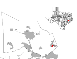
Montgomery County is a county in the U.S. state of Texas. As of the 2020 U.S. census, the county had a population of 620,443. The county seat is Conroe. The county was created by an act of the Congress of the Republic of Texas on December 14, 1837, and is named for the town of Montgomery. Between 2000 and 2010, its population grew by 55%, the 24th-fastest rate of growth of any county in the United States. Between 2010 and 2020, its population grew by 36%. According to the U.S. Census Bureau, the estimated population is 711,354 as of July 1, 2023.

<span class="mw-page-title-main">San Jacinto County, Texas</span> County in Texas, United States

San Jacinto County is a county in the U.S. state of Texas. As of the 2020 census, its population was 27,402. Its county seat is Coldspring. The county's name comes from the Battle of San Jacinto which secured Texas' independence from Mexico and established a republic in 1836.

<span class="mw-page-title-main">Matagorda County, Texas</span> County in Texas, United States

Matagorda County is a county located in the U.S. state of Texas. As of the 2020 census, the population was 36,255. Its county seat is Bay City, not to be confused with the larger Baytown in Harris and Chambers Counties. Matagorda County is named for the canebrakes that once grew along the coast.

<span class="mw-page-title-main">Crystal Lawns, Illinois</span> Census designated place

Crystal Lawns is a census-designated place (CDP) in Will County, Illinois, United States. The population was 1,830 at the 2020 census.

<span class="mw-page-title-main">Caney, Kansas</span> City in Montgomery County, Kansas

Caney is a city in Montgomery County, Kansas, United States. As of the 2020 census, the population of the city was 1,788.

<span class="mw-page-title-main">Brazoria, Texas</span> City in Texas, United States

Brazoria is a city in the U.S. state of Texas, in the Houston–The Woodlands–Sugar Land metropolitan area and Brazoria County. As of the 2020 census, the city population was 2,866.

<span class="mw-page-title-main">Freeport, Texas</span> City in Texas, United States

Freeport is a city in Brazoria County, Texas, United States, located on the Gulf of Mexico. According to the 2020 census, the city population was 10,696, down from 12,049 in 2010.

<span class="mw-page-title-main">Cloverleaf, Texas</span> Census-designated place in Texas, United States

Cloverleaf is a census-designated place (CDP) in east central Harris County, Texas, United States. The population was 24,100 at the 2020 census.

<span class="mw-page-title-main">Cut and Shoot, Texas</span> City in Texas, United States

Cut and Shoot is a city in eastern Montgomery County, Texas, United States, about 6 mi (9.7 km) east of Conroe and 40 mi (64 km) north of Houston. Until 2006, Cut and Shoot was considered and called a town. Then, the town council elected for it to be considered and referred to as a city. The population was 1,087 at the 2020 census.

<span class="mw-page-title-main">Magnolia, Texas</span> City in Texas, United States

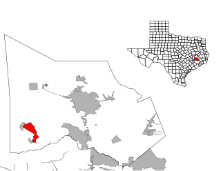
Magnolia is a city in southwestern Montgomery County, Texas, United States within the Houston metropolitan area. It is named for the magnolia trees that grow in the area. The population was 2,359 at the 2020 United States Census.

<span class="mw-page-title-main">Montgomery, Texas</span> City in Texas, United States

Montgomery is a city located in Montgomery County, Texas, United States. As of the 2020 census, the city had a total population of 1,948.

<span class="mw-page-title-main">Pinehurst, Montgomery County, Texas</span> Census designated place in Texas, United States

Pinehurst is a census-designated place (CDP) in Montgomery County, Texas, United States. The population was 5,195 at the 2020 census.

<span class="mw-page-title-main">Porter Heights, Texas</span> Populated place in Texas, United States

Porter Heights is a census-designated place (CDP) in Montgomery County, Texas, United States. The population was 1,903 at the 2020 census.

<span class="mw-page-title-main">Willis, Texas</span> City in Texas, United States

Willis is a city in Montgomery County, Texas, United States, located eight miles north of Conroe in north central Montgomery County. The city began to develop in 1870 after what is now the Union Pacific Railroad built track through the area. As a part of the Piney Woods, the Willis economy has historically been driven by lumber, agriculture, and the manufacture of lumber and agriculture equipment. From the late nineteenth to early twentieth century, it produced tobacco as a commodity crop. Competition from Cuba reduced its contribution to the economy.

<span class="mw-page-title-main">Woodbranch, Texas</span> City in Texas, United States

Woodbranch Village, also known simply as "Woodbranch," is a city in Montgomery County, Texas, United States. The population was 1,330 at the 2020 census.

<span class="mw-page-title-main">West Lake Hills, Texas</span> City in Texas, United States

West Lake Hills is a city in Travis County, Texas, United States. The population was 3,444 at the 2020 census. The city developed rapidly in the 1970s and 1980s on the south side of the Colorado River.

<span class="mw-page-title-main">Aransas Pass, Texas</span> City in Texas, United States

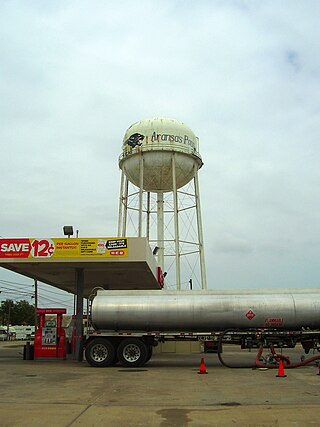
Aransas Pass is a city in Aransas, Nueces, and San Patricio Counties in the U.S. state of Texas. The population was 8,011 at the 2021 Census.

<span class="mw-page-title-main">Waller, Texas</span> City in Texas, United States

Waller is a city in Texas, United States, partly in Waller County and partly in Harris County within the Houston–Cypress metropolitan area. Its population was 2,682 at the 2020 U.S. census. The Waller area is located along U.S. Route 290 41 miles (66 km) northwest of downtown Houston.

New Caney Independent School District (NCISD) is a public school district based in New Caney—an unincorporated area of southeastern Montgomery County, Texas (USA) within the Houston–The Woodlands–Sugar Land metropolitan area.

<span class="mw-page-title-main">Porter, Texas</span> Unincorporated community in Texas, United States

Porter is an unincorporated community in Montgomery County in Southeastern Texas, United States, within the Houston–The Woodlands–Sugar Land metropolitan area. In 2010, its population was estimated at 25,769. Porter is north of the Kingwood area of Houston.

References

  1. 1 2 Council Members. City of Roman Forest. Retrieved June 10, 2022.
  2. "2019 U.S. Gazetteer Files". United States Census Bureau. Retrieved August 7, 2020.
  3. "U.S. Census website". United States Census Bureau . Retrieved January 31, 2008.
  4. "US Board on Geographic Names". United States Geological Survey. October 25, 2007. Retrieved January 31, 2008.
  5. Roman Forest Police Department. Retrieved March 31, 2020.
  6. Municipal Court. City of Roman Forest. Retrieved March 31, 2020.
  7. About Us. East Montgomery County Fire Department. Retrieved March 31, 2020.
  8. 1 2 Who Represents Me: Roman Forest. Texas Legislative Council. Accessed on July 6, 2017.
  9. Find Locations: New Caney. United States Postal Service. Accessed on July 6, 2017.
  10. "US Gazetteer files: 2010, 2000, and 1990". United States Census Bureau. February 12, 2011. Retrieved April 23, 2011.
  11. Climate Summary for Roman Forest, Texas
  12. "Census of Population and Housing". Census.gov. Retrieved June 4, 2015.
  13. "Explore Census Data". data.census.gov. Retrieved May 23, 2022.
  14. https://www.census.gov/ [ not specific enough to verify ]
  15. "About the Hispanic Population and its Origin". www.census.gov. Retrieved May 18, 2022.
  16. Factfinder: Roman Forest. Archived February 13, 2020, at archive.today United States Census Bureau. Accessed on July 6, 2017.
  17. "SCHOOL DISTRICT REFERENCE MAP (2010 CENSUS): Montgomery County, TX" (Archive). U.S. Census Bureau. Retrieved on August 20, 2015.
  18. "2010 CENSUS - CENSUS BLOCK MAP: Roman Forest town, TX" (Archive). U.S. Census Bureau. Retrieved on September 11, 2015.
  19. 1 2 Attendance Zones. New Caney Independent School District. Accessed on July 6, 2017.
  20. "Elementary Zones [ permanent dead link ]." New Caney Independent School District. Retrieved on January 20, 2011. [ dead link ]
  21. "Tavola Elementary School Opens August 2015" (Archive). New Caney Independent School District. Retrieved on September 11, 2015.
  22. Texas Education Code, Sec. 130.191. LONE STAR COLLEGE SYSTEM DISTRICT SERVICE AREA..