Prospect, Ohio

Last updated

Prospect, Ohio
Water from Elm, Prospect.jpg
Water Street downtown
OHMap-doton-Prospect.png
Location of Prospect, Ohio
Map of Marion County Ohio Highlighting Prospect Village.png
Location of Prospect in Marion County
Coordinates: 40°27′14″N83°11′05″W / 40.45389°N 83.18472°W / 40.45389; -83.18472
Country United States
State Ohio
County Marion
Township Prospect
Area
[1]
  Total0.72 sq mi (1.87 km2)
  Land0.72 sq mi (1.87 km2)
  Water0.00 sq mi (0.00 km2)
Elevation
[2]
906 ft (276 m)
Population
 (2020)
  Total1,067
  Density1,473.76/sq mi (569.31/km2)
Time zone UTC-5 (Eastern (EST))
  Summer (DST) UTC-4 (EDT)
ZIP code
43342
Area code 740
FIPS code 39-64780 [3]
GNIS feature ID2399027 [2]

Prospect is a village in Marion County, Ohio, United States. The population was 1,067 at the 2020 census. The village is served by Elgin Local School District.

Contents

Geography

According to the United States Census Bureau, the village has a total area of 0.72 square miles (1.86 km2), all land. [4]

Demographics

Historical population
CensusPop.Note
1880 600
1890 83038.3%
1900 98318.4%
1910 945−3.9%
1920 9490.4%
1930 1,0136.7%
1940 915−9.7%
1950 1,03112.7%
1960 1,0673.5%
1970 1,031−3.4%
1980 1,15912.4%
1990 1,148−0.9%
2000 1,1913.7%
2010 1,112−6.6%
2020 1,067−4.0%
U.S. Decennial Census [5]

2010 census

As of the census [6] of 2010, there were 1,112 people, 453 households, and 304 families living in the village. The population density was 1,544.4 inhabitants per square mile (596.3/km2). There were 494 housing units at an average density of 686.1 per square mile (264.9/km2). The racial makeup of the village was 98.1% White, 0.3% African American, 0.2% Asian, 0.4% from other races, and 1.1% from two or more races. Hispanic or Latino of any race were 1.3% of the population.

There were 453 households, of which 33.6% had children under the age of 18 living with them, 50.6% were married couples living together, 9.9% had a female householder with no husband present, 6.6% had a male householder with no wife present, and 32.9% were non-families. 26.9% of all households were made up of individuals, and 9.3% had someone living alone who was 65 years of age or older. The average household size was 2.45 and the average family size was 2.97.

The median age in the village was 37.5 years. 25.5% of residents were under the age of 18; 7.9% were between the ages of 18 and 24; 26.8% were from 25 to 44; 27.8% were from 45 to 64; and 12.1% were 65 years of age or older. The gender makeup of the village was 50.0% male and 50.0% female.

2000 census

As of the census [3] of 2000, there were 1,191 people, 469 households, and 343 families living in the village. The population density was 1,642.9 inhabitants per square mile (634.3/km2). There were 490 housing units at an average density of 675.9 per square mile (261.0/km2). The racial makeup of the village was 99.41% White, 0.08% Native American, 0.08% from other races, and 0.42% from two or more races.

There were 469 households, out of which 36.0% had children under the age of 18 living with them, 59.9% were married couples living together, 8.5% had a female householder with no husband present, and 26.7% were non-families. 21.5% of all households were made up of individuals, and 9.4% had someone living alone who was 65 years of age or older. The average household size was 2.54 and the average family size was 2.97.

In the village, the population was spread out, with 25.6% under the age of 18, 8.9% from 18 to 24, 30.5% from 25 to 44, 22.6% from 45 to 64, and 12.4% who were 65 years of age or older. The median age was 36 years. For every 100 females there were 97.8 males. For every 100 females age 18 and over, there were 96.9 males.

The median income for a household in the village was $46,316, and the median income for a family was $54,063. Males had a median income of $35,429 versus $23,636 for females. The per capita income for the village was $20,324. About 2.1% of families and 2.6% of the population were below the poverty line, including 1.3% of those under age 18 and 7.9% of those age 65 or over.

Related Research Articles

Bradley is a town in Penobscot County, Maine, United States. It is part of the Bangor Metropolitan Statistical Area. The population was 1,532 at the 2020 census. The village of Bradley is in the northwestern corner of the town.

<span class="mw-page-title-main">Sycamore Hills, Missouri</span> Village in Missouri, United States

Sycamore Hills is a village in St. Louis County, Missouri, United States. The population is 560 at the 2020 census.

<span class="mw-page-title-main">Westwood, Missouri</span> Village in Missouri, United States

Westwood is a village in west St. Louis County, Missouri, United States. The population was 316 at the 2020 census.

<span class="mw-page-title-main">Wilbur Park, Missouri</span> Village in Missouri, United States

Wilbur Park is a village in St. Louis County, Missouri, United States. The population was 439 at the 2020 census.

<span class="mw-page-title-main">Hanley Hills, Missouri</span> Village in Missouri, United States

Hanley Hills is a village in St. Louis County, Missouri, United States. The population was 2,101 at the 2010 census.

<span class="mw-page-title-main">Fort Shawnee, Ohio</span> CDP in Ohio, United States

Fort Shawnee is census-designated place (CDP) in Allen County, Ohio, United States. The population was 6,263 at the 2020 census. It is included in the Lima, Ohio Metropolitan Statistical Area. Fort Shawnee is adjacent to the city of Lima and the village of Cridersville in Auglaize County. In 2012, village residents voted to disincorporate the village. According to the United States Census Bureau, the village had a total area of 7.25 square miles (18.78 km2), of which 7.21 square miles (18.67 km2) is land and 0.04 square miles (0.10 km2) is water.

<span class="mw-page-title-main">Brookside, Ohio</span> Village in Ohio, United States

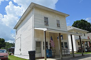
Brookside is a village in eastern Belmont County, Ohio, United States. The population was 538 at the 2020 census. It is part of the Wheeling metropolitan area.

<span class="mw-page-title-main">Brice, Ohio</span> Village in Ohio, United States

Brice is a village in Franklin County, Ohio, United States, on the southeast side of the Columbus metropolitan area. The population was 93 at the 2020 census.

<span class="mw-page-title-main">Addyston, Ohio</span> Village in Ohio, United States

Addyston is a village in Miami Township, Hamilton County, Ohio, United States. Located along the Ohio River, it is a western suburb of the neighboring city of Cincinnati. The population was 927 at the 2020 census.

<span class="mw-page-title-main">Cleves, Ohio</span> City in Ohio, United States

Cleves is a village in Miami Township, Hamilton County, Ohio, United States. Located along the Ohio River, it is a western suburb of Cincinnati. The population was 3,414 at the 2020 census.

<span class="mw-page-title-main">St. Louisville, Ohio</span> Village in Ohio, United States

St. Louisville or Saint Louisville is a village in Licking County, Ohio, United States, along the North Fork of the Licking River. The population was 352 at the 2020 census.

<span class="mw-page-title-main">Sheffield, Ohio</span> Village in Ohio, United States

Sheffield is a village in Lorain County, Ohio, United States, along the Black River. The population was 4,135 at the 2020 census. It is part of the Cleveland metropolitan area.

<span class="mw-page-title-main">Sparta, Ohio</span> Village in Ohio, United States

Sparta is a village in Morrow County, Ohio, United States. The population was 121 at the 2020 census. Sparta is southeast of Mount Gilead, the county seat.

<span class="mw-page-title-main">Haviland, Ohio</span> Village in Ohio, United States

Haviland is a village in Paulding County, Ohio, United States. The population was 160 at the 2020 census.

<span class="mw-page-title-main">Hartville, Ohio</span> Village in Ohio, United States

Hartville is a village in northern Stark County, Ohio, United States. The population was 3,329 at the 2020 census. It is part of the Canton–Massillon metropolitan area. Hartville lies halfway between Akron and Canton at the intersection of State Routes 43 and 619.

<span class="mw-page-title-main">Bellevue, Wisconsin</span> Village in Wisconsin, United States

Bellevue is a village in Brown County, Wisconsin. It was a town until incorporating as a village on February 14, 2003. The population was 15,935 at the time of the 2020 census. Bellevue is part of the Green Bay metropolitan area. Bellevue sits around 4.34 miles (6.99 km) east from central Green Bay.

<span class="mw-page-title-main">Kekoskee, Wisconsin</span> Village in Wisconsin, United States

Kekoskee is a village in Dodge County, Wisconsin, United States. The population was 161 at the 2010 census.

<span class="mw-page-title-main">Avoca, Wisconsin</span> Village in Wisconsin, United States

Avoca is a village in Iowa County, Wisconsin, United States. The population was 637 at the 2010 census. It is part of the Madison Metropolitan Statistical Area. It is named after Avoca in Ireland.

<span class="mw-page-title-main">Verona, Ohio</span> Village in Ohio, United States

Verona is a village in Montgomery and Preble counties in the U.S. state of Ohio. The population was 403 at the 2020 census. It is part of the Dayton Metropolitan Statistical Area.

<span class="mw-page-title-main">Lowell, Wisconsin</span> Village in Wisconsin, United States

Lowell is a village in Dodge County, Wisconsin, United States, along the Beaver Dam River. The population was 340 at the 2010 census. The village is located within the Town of Lowell.

References

  1. "ArcGIS REST Services Directory". United States Census Bureau. Retrieved September 20, 2022.
  2. 1 2 U.S. Geological Survey Geographic Names Information System: Prospect, Ohio
  3. 1 2 "U.S. Census website". United States Census Bureau . Retrieved January 31, 2008.
  4. "US Gazetteer files 2010". United States Census Bureau. Archived from the original on January 25, 2012. Retrieved January 6, 2013.
  5. "Census of Population and Housing". Census.gov. Retrieved June 4, 2015.
  6. "U.S. Census website". United States Census Bureau . Retrieved January 6, 2013.