Prospect dolerite intrusion

Last updated

Prospect dolerite intrusion
Stratigraphic range: Early Jurassic or Middle Jurassic
Prospect Hill Quarry.jpg
View of intrusion from Prospect Highway
Typeigneous
Overlies Ashfield Shale and Sydney sandstone
Area2.4 kms by 1.4 kms
Thickness76.2 metres (250 ft)
Lithology
Primary picrite, dolerite, prehnite, basalt, calcite, pegmatite, etc
Location
Coordinates 33°49′30″S150°55′5″E / 33.82500°S 150.91806°E / -33.82500; 150.91806
Region Western Sydney, New South Wales
Country Australia
Extent City of Blacktown and Cumberland City Council
Type section
Named for Prospect, New South Wales
Named byGovernor Arthur Phillip and Lieutenant (later Governor) Philip Gidley King [1]

The Prospect dolerite intrusion, or Prospect intrusion, is a Jurassic picrite or dolerite laccolith that is situated in Sydney, New South Wales, Australia. [2] Lying in the heart of Cumberland Plain, in the suburb of Pemulwuy (previously Greystanes), the intrusion is Sydney's largest body of igneous rock, rising to a height of 117 metres (384 ft) above sea level. [3] The site is formed by an intrusion of dolerite rock into Ashfield Shale. At least seven different rock types occur in the intrusion.

Contents

The site was formed from around 200 million years ago when volcanic material (hot magmatic fluids) from the Earth's upper mantle moved upwards and then sideways, which produced many different minerals in the upper part. Also known as Prospect Quarry, the eroded residue of the volcanic core became a quarry of the basalt plug that was carried out from 1820s until the late 2000s, where it contributed most of the crushed rock that were used for building construction and roads in the Sydney area. The intrusion comprises: prospect dolerite and prospect teschenite, in addition to an abundance of coarse grained picrite, olivine and its prehnite specimens. [4]

Igneous activity

Formation

Diagram of igneous structures (laccolith is C on top-right). Igneous structures.jpg
Diagram of igneous structures (laccolith is C on top-right).

In the Sydney Basin, igneous activity took place in the Early Jurassic activity that resulted in the shaping of the Prospect dolerite intrusion – This unambiguously points that the site had a volcanic origin. [5] The eroded residue of the volcanic core forms the site, which was battered down over millions of years to a small extrusion in the relatively flat lands of western Sydney. [6]

Consequent to the volcanic activity, which determined the shape of the Prospect dolerite intrusion many million years ago, erosion then undermined the main mass of volcanic material and caused it to fall in on itself and create a shallow, dish-shaped formation with shrinkage cracks that established in the intrusion, as shown by the salient cooled edges of basalt formed by high heat difference between the comparatively cool (and likely wet) sediments and the magma. [7]

This allowed hot magmatic fluids, which are around 900–1,000 °C (1,620–1,800 °F), to relocate via developing pegmatite and depositing prehnite, calcite and other subsidiary minerals that are found in the upper part of the intrusion, with analcime dolerite (teschenite) and picrite shaping the bulk of the intrusion site. [8]

Erosion

At the next stage of its geological development, which lasted over 60 million years, was the gradual erosion of the overlying layers of sedimentary rock by the motion of rainwater, which ultimately revealed the edges of the volcanic and metamorphic rocks of the Prospect intrusion. [9] The intrusion has been an inadvertent outcome of tense continental crust breaking all the way down to the upper mantle during development of the rift divergence zone that occurred before the breakup of the Australian and Antarctic continents in the Eocene epoch.

The fractures acted as pathway for basaltic magma from the mantle area and a few of these would have been feeder dikes for the intrusion, whereby the magma ascended to an area of density equilibrium inside the surface rocks. [10] The site's heat transformed the nature of the encompassing rock to produce many type of minerals, which were mainly coarse-grained picrite, alongside olivine-dolerite. The picrite did not extend to the surface, though it thrusted the surface rocks upwards to create a dome. [11]

Geological description

Dolerite intrusion overlying Ashfield Shale Prospectdolerite.jpg
Dolerite intrusion overlying Ashfield Shale

The Prospect Intrusion is one of many Mesozoic intrusions that were dispositioned into the Sydney Basin depositional area at the conjunction of the Triassic fluvial Sydney sandstone and the lacustrine Ashfield Shale which underlies the intrusion. The site is 60 metres (197 ft) above ground level and 122 metres (400 ft) above sea level, and is 2.4 kilometres (1 mi) long and 1.4 kilometres (1 mi). [12] The dolerite intrusion is a circular teschenite encroachment that has intruded the Triassic Wianamatta shale, with the intrusion's external, elliptic shaped portion featuring dissentious impinging. The intrusion site has a sill that is roughly 76.2 metres (250 ft) thick and is covered by 6.09 metres (20 ft) to 21.3 metres (70 ft) of shale. [13]

The dome is called a doleritic laccolith. A regular laccolith's intruded material features a rather flat lower surface and a bell-shaped upper surface, where it is more like half a lens in shape. Though because of the descent of the volcanic material, combined with consequent surface erosion, the laccolith maintained a concave upper surface until present, due to quarrying altering its shape, owing to its description as "caldera-like". The intrusion has been stratified, but that depends on how its parts distinguished when it cooled down. [14]

Minerals

The hill contains a slender, chilled margin of fine-grained basalt with most of the mass of the intrusion being made up of picrite, dolerite, and high level intrusives. The picrite is a farinaceous-grained rock dominated by olivine and is made up of two-thirds of the lower constituent of the intrusion, with the upper third of dolerite also containing other mafic minerals. The shales above and below the intrusion had very reduced levels of metamorphism and exhibited superficial modification to a fine quartz hornfels with nearly no growth in grain size. [15]

The quarried hill today, with dolerite intrusion on sandstone and shale. Prospect igneous.jpg
The quarried hill today, with dolerite intrusion on sandstone and shale.

The copious amount of analcime in the rocks at the intrusion's top shows significant reservation of magmatic water during crystallization. If venting of the hydrothermal fluids into the encompassing sediments had happened, the diverse range of unique rock types and related late-stage minerals wouldn't have formed. [16] Volcaniclastic sediments were rare and volcanic rocks on the site are predominantly mafic. In the 1960s, a small amount of gold was observed in a sample test, but since then no more has been discovered. [17]

The site also has had a sweeping collection of other minerals, such as: [18]

History

Discovery, 1788–91

The area of Prospect Reservoir is an area of known Aboriginal occupation, with favorable camping locations along the Eastern Creek and Prospect Creek catchments, and in elevated landscapes to the south. The area was settled by Europeans by 1789. On 26 April 1788, an exploration party heading west led by Governor Phillip, climbed the site, which was known as Prospect Hill or "Bellevue". An account by Phillip states that the exploration party saw from Prospect Hill, "for the first time since we landed Carmathen [sic] Hills (Blue Mountains) as likewise the hills to the southward". On 18 July 1791 Phillip placed a number of men on the eastern and southern slopes of Prospect Hill, as the soils weathered from the basalt cap were richer than the sandstone derived soils of the Cumberland Plain. [19]

The site provided a point from which distances could be meaningfully calculated, and became a major reference point for other early explorers. [20] [21] While there is no documentary evidence of Watkin Tench having named Prospect Hill, there is no doubt that it is in fact the hill that was shortly afterwards known by that name. In view of Tench's literary allusions to Milton's Paradise Lost , it seems highly probable that the experience of climbing it reminded him of the "goodly prospect of some forein land first-seen" by Milton's scout and that it was indeed Tench who first named it. [22] [ original research? ]

Observation, 19th century

Quarrying of the basalt plug in the area began in the 1820s. Charles Darwin visited this site in 1835, where he states in his notebook Notes on the Geology of places visited during the Voyage: [23]

"At Prospect Hill the sandstone country is intermitted by a mass of Trappean rocks, the quarry which I saw consisted of a black Basalt(?) the structure of which was roughly prismatic. I imagine, but have no proof that this has burst through the Sandstone."

James Dwight Dana, an American geologist, arrived in Sydney in on 29 November 1839 and visited the intrusion site. In January 1840, William Branwhite Clarke, geologist and Church of England reverend, travelled with Dana to the intrusion site to study the rocks. Dana analysed material from the site and recorded his expedition in Vol 10 of the United States Exploring Expedition. Dana described the rock material from Prospect as: [24]

"A dark bluish rock, finely porphyritic, with small points (not tables) of feldspar. It occurs at Prospect Hill...A porphyritic basalt, in which the augite and feldspar are both distinct, and some of the crystals of the augite are a fourth of an inch long. It occurs at Prospect Hill...The compact black basalt changes to a compact rock, with disseminated points of feldspar; next, to a porphyritic basalt, with distinct crystals of both augite and feldspar; and next, to the feldspar rock in which Augite is almost wholly wanting."

Land development, 1900s–present

The Prospect intrusion site in 2009, before industrial estate construction. Prospect Quarry.jpg
The Prospect intrusion site in 2009, before industrial estate construction.

The bulk of the present CSIRO site was acquired by the Commonwealth in 1946, and a further 15 hectares was acquired in 1963, which became the primary source of roadstone for the city's expanding infrastructure until the reserves of dolerite were exhausted. In 1998 Boral reviewed its holdings with a view to future redevelopment as its quarry neared the end of its life. As at February 2001, the southern portion of the site, located within the Boral Brickworks site has been extensively quarried. The area is under immediate threat from development, which has the potential to impact upon the significance of the site.

The then Minister for Urban Affairs & Planning took over planning powers for the employment area in November 2000 and approved the Employment Precinct Plan in June 2001, approving subdivision and associated works in the northern employment lands later in June 2001. Since, parts of the employment land have been sold and further subdivided and sold. The gap in the ridge that had previously been created by quarrying has been lowered to the floor level of the quarry and the drainage of the area reversed from its earlier northward flow to empty into Prospect Creek, while a new road, Reconciliation Road, has been driven through the centre of the hill from Prospect Highway and across the gap to Wetherill Park. The land inside the oval-shaped site was levelled from 2008 to 2010 and is rapidly filling with large industrial buildings. [25]

Heritage listing

As at 19 February 2001, the area where the dolerite intrusion is situated in had state significance due to its unique combination of significant landscape feature, potential archaeological site, and association with important historical phases. As a dolerite outcrop that rises to a height of 117 metres (384 ft) AHD , it is a unique geological and significant topographic feature providing panoramic views across the Cumberland Plain. The intrusion site, which is situated on Prospect Hill, was added to the New South Wales State Heritage Register on 17 October 2003. [26] The site is mentioned in the 'SHR Criteria C', under 'Aesthetic significance':

Prospect Hill has aesthetic significance as Sydney's largest body of igneous rock, which rises to a height of 117 metres and provides expansive views across the Cumberland Plain. The large dolerite formation of Prospect Hill is a rare geological and landmark topographic feature, lying centrally within the Cumberland Plain. [3]

See also

Related Research Articles

<span class="mw-page-title-main">Gabbro</span> Coarse-grained mafic intrusive rock

Gabbro is a phaneritic (coarse-grained), mafic intrusive igneous rock formed from the slow cooling of magnesium-rich and iron-rich magma into a holocrystalline mass deep beneath the Earth's surface. Slow-cooling, coarse-grained gabbro is chemically equivalent to rapid-cooling, fine-grained basalt. Much of the Earth's oceanic crust is made of gabbro, formed at mid-ocean ridges. Gabbro is also found as plutons associated with continental volcanism. Due to its variant nature, the term gabbro may be applied loosely to a wide range of intrusive rocks, many of which are merely "gabbroic". By rough analogy, gabbro is to basalt as granite is to rhyolite.

<span class="mw-page-title-main">Trachyte</span> Extrusive igneous rock

Trachyte is an extrusive igneous rock composed mostly of alkali feldspar. It is usually light-colored and aphanitic (fine-grained), with minor amounts of mafic minerals, and is formed by the rapid cooling of lava enriched with silica and alkali metals. It is the volcanic equivalent of syenite.

<span class="mw-page-title-main">Diabase</span> Type of igneous rock

Diabase, also called dolerite or microgabbro, is a mafic, holocrystalline, subvolcanic rock equivalent to volcanic basalt or plutonic gabbro. Diabase dikes and sills are typically shallow intrusive bodies and often exhibit fine-grained to aphanitic chilled margins which may contain tachylite.

<span class="mw-page-title-main">Intrusive rock</span> Magmatic rock formed below the surface

Intrusive rock is formed when magma penetrates existing rock, crystallizes, and solidifies underground to form intrusions, such as batholiths, dikes, sills, laccoliths, and volcanic necks.

<span class="mw-page-title-main">Pyroxenite</span> Igneous rock

Pyroxenite is an ultramafic igneous rock consisting essentially of minerals of the pyroxene group, such as augite, diopside, hypersthene, bronzite or enstatite. Pyroxenites are classified into clinopyroxenites, orthopyroxenites, and the websterites which contain both types of pyroxenes. Closely allied to this group are the hornblendites, consisting essentially of hornblende and other amphiboles.

<span class="mw-page-title-main">Tachylite</span> Form of basaltic volcanic glass

Tachylite is a form of basaltic volcanic glass. This glass is formed naturally by the rapid cooling of molten basalt. It is a type of mafic igneous rock that is decomposable by acids and readily fusible. The color is a black or dark-brown, and it has a greasy-looking, resinous luster. It is very brittle and occurs in dikes, veins, and intrusive masses. The word originates from the Ancient Greek ταχύς, meaning "swift".

<span class="mw-page-title-main">Sydney Basin</span> Sedimentary basin and region in New South Wales, Australia

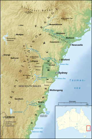
The Sydney Basin is an interim Australian bioregion and is both a structural entity and a depositional area, now preserved on the east coast of New South Wales, Australia and with some of its eastern side now subsided beneath the Tasman Sea. The basin is named for the city of Sydney, on which it is centred.

<span class="mw-page-title-main">Komatiite</span> Magnesium-rich igneous rock

Komatiite is a type of ultramafic mantle-derived volcanic rock defined as having crystallised from a lava of at least 18 wt% magnesium oxide (MgO). It is classified as a 'picritic rock'. Komatiites have low silicon, potassium and aluminium, and high to extremely high magnesium content. Komatiite was named for its type locality along the Komati River in South Africa, and frequently displays spinifex texture composed of large dendritic plates of olivine and pyroxene.

<span class="mw-page-title-main">Picrite basalt</span> Variety of high-magnesium basalt that is very rich in the mineral olivine

Picrite basalt or picrobasalt is a variety of high-magnesium olivine basalt that is very rich in the mineral olivine. It is dark with yellow-green olivine phenocrysts (20-50%) and black to dark brown pyroxene, mostly augite.

<span class="mw-page-title-main">Prospect, New South Wales</span> Suburb of Sydney, New South Wales, Australia

Prospect is a suburb of Sydney, in the state of New South Wales, Australia. Prospect is located 32 kilometres west of the Sydney central business district in the local government area of the City of Blacktown and a small part of Cumberland City Council, is part of the Greater Western Sydney region. One of the oldest suburbs in Sydney, Prospect takes its name from the prominent nearby landmark of Prospect Hill - from the top of which people could get a prospect of the surrounding countryside.

<span class="mw-page-title-main">Pemulwuy, New South Wales</span> Suburb of Greater Western Sydney, New South Wales, Australia

Pemulwuy is a suburb in Greater Western Sydney, in the state of New South Wales, Australia. Pemulwuy is located 30 kilometres west of the Sydney central business district in the local government area of the Cumberland Council. Pemulwuy is home to the highest point between the Blue Mountains and Sydney, the summit of Prospect Hill.

<span class="mw-page-title-main">Geology of the Australian Capital Territory</span> Overview of the geology of the Australian Capital Territory

The geology of the Australian Capital Territory includes rocks dating from the Ordovician around 480 million years ago, whilst most rocks are from the Silurian. During the Ordovician period the region—along with most of eastern Australia—was part of the ocean floor. The area contains the Pittman Formation consisting largely of quartz-rich sandstone, siltstone and shale; the Adaminaby Beds and the Acton Shale.

<span class="mw-page-title-main">Leucitite</span>

Leucitite or leucite rock is an igneous rock containing leucite. It is scarce, many countries such as England being entirely without them. However, they are of wide distribution, occurring in every quarter of the globe. Taken collectively, they exhibit a considerable variety of types and are of great interest petrographically. For the presence of this mineral it is necessary that the silica percentage of the rock should be low, since leucite is incompatible with free quartz and reacts with it to form potassium feldspar. Because it weathers rapidly, leucite is most common in lavas of recent and Tertiary age, which have a fair amount of potassium, or at any rate have potassium equal to or greater than sodium; if sodium is abundant nepheline occurs rather than leucite.

<span class="mw-page-title-main">Geology of Jersey</span>

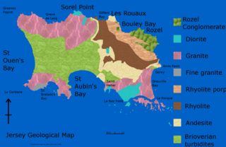
The geology of Jersey is characterised by the Late Proterozoic Brioverian volcanics, the Cadomian Orogeny, and only small signs of later deposits from the Cambrian and Quaternary periods. The kind of rocks go from conglomerate to shale, volcanic, intrusive and plutonic igneous rocks of many compositions, and metamorphic rocks as well, thus including most major types.

<span class="mw-page-title-main">Geology of Tasmania</span> Overview of the geology of Tasmania

The geology of Tasmania is complex, with the world's biggest exposure of diabase, or dolerite. The rock record contains representatives of each period of the Neoproterozoic, Paleozoic, Mesozoic and Cenozoic eras. It is one of the few southern hemisphere areas that were glaciated during the Pleistocene with glacial landforms in the higher parts. The west coast region hosts significant mineralisation and numerous active and historic mines.

<span class="mw-page-title-main">Alkali basalt</span> Type of volcanic rock

Alkali basalt or alkali olivine basalt is a dark-colored, porphyritic volcanic rock usually found in oceanic and continental areas associated with volcanic activity, such as oceanic islands, continental rifts and volcanic fields. Alkali basalt is characterized by relatively high alkali (Na2O and K2O) content relative to other basalts and by the presence of olivine and titanium-rich augite in its groundmass and phenocrysts, and nepheline in its CIPW norm.

<span class="mw-page-title-main">Igneous rock</span> Rock formed through the cooling and solidification of magma or lava

Igneous rock, or magmatic rock, is one of the three main rock types, the others being sedimentary and metamorphic. Igneous rocks are formed through the cooling and solidification of magma or lava.

<span class="mw-page-title-main">Prospect Hill (New South Wales)</span>

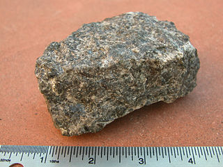
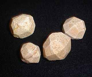
Prospect Hill, or Marrong Reserve, is a heritage-listed hill in Pemulwuy and Prospect in the greater western region of Sydney, New South Wales, Australia. Situated about 30 kilometres west of central Sydney, the hill is Sydney's largest body of igneous rock and is higher than the ridges of the Cumberland Plain around it, with its present-day highest point being 117 metres high, although before its summit was quarried away it rose to a height of 131 metres above sea level.

São Tomé and Príncipe both formed within the past 30 million years due to volcanic activity in deep water along the Cameroon line. Long-running interactions with seawater and different eruption periods have generated a wide variety of different igneous and volcanic rocks on the islands with complex mineral assemblages.

References

  1. King, P. G. (1793). Hunter, J. (ed.). An Historical Journal of the Transactions at Port Jackson and Norfolk Island. London: Stockdale.
  2. Igneous intrusions by the Australian Museum. 13 November 2018. Retrieved 1 November 2021.
  3. 1 2 Ashton, W. (2000). Landscape Heritage Assessment: CSIRO Division of Animal Production.
  4. NSW Government Architect's Office, Prospect Hill Heritage Landscape Study and Plan, NSW Department of Commerce, 2008, p 31.
  5. Johnson R. W. (1989). Volcano distribution and classification. In: Johnson R. W., Knutson J. And Taylor S. R. eds. Intraplate Volcanism: In Eastern Australia and New Zealand, pp. 7 11. Cambridge University Press, Cambridge, UK.
  6. Robert Wallace Johnson (24 November 1989). Intraplate Volcanism: In Eastern Australia and New Zealand. Cambridge University Press. pp. 4–. ISBN   978-0-521-38083-6.
  7. Jones, I., and Verdel, C. (2015). Basalt distribution and volume estimates of Cenozoic volcanism in the Bowen Basin region of eastern Australia: Implications for a waning mantle plume. Australian Journal of Earth Sciences, 62(2), 255-263.
  8. Branagan, D.F., and Packham, G.H., 2000. Field Geology of New South Wales. 3rd Edition. New South Wales Department of Mineral Resources, Sydney.
  9. Conybeare Morrison, Prospect Hill Conservation Management Plan, Holroyd City Council, 2005
  10. Jones, I., Verdel, C., Crossingham, T., and Vasconcelos, P. (2017). Animated reconstructions of the Late Cretaceous to Cenozoic northward migration of Australia, and implications for the generation of east Australian mafic magmatism. Geosphere, 13(2), 460-481.
  11. Compton, K., Mindat: Prospect, New South Wales
  12. William M.L. & Carr P.F., Isotope systematics of secondary minerals from the Prospect Intrusion, New South Wales, Australian Journal of Earth Sciences (2005) Volume 52, Issue 6, 2005
  13. Wilshire, HG, The Prospect Alkaline Diabase-Picrite Intrusion New South Wales, Australia, Journal of Petrology (1967) 8 (1): pp 97-163
  14. Wilshire: Wilshire, H.G., The Prospect alkaline diabase-picrite intrusion, New South Wales, Australia in Journal of Petrology, Vol. 8 (1), pp 97-163, 1967.
  15. Prospect, New South Wales By Keith Compton, Mindat.org, Hudson Institute of Mineralogy 1993-2021. Retrieved 1 November 2021.
  16. HODGE-SMITH, T. (1943) Mineralogical notes No. VI. Records of the Australian Museum, 21 (4), 251.
  17. England, B. M. (1994) Minerals of the Prospect Intrusion, New South Wales, Australia. Mineralogical Record 25, pp.185-194.
  18. CLARK, B. (1976) The Prospect Intrusion. Mineralogical News, 12, 8-11.
  19. Higginbotham, Edward (2000). Historical and Archaeological Assessment of CSIRO site.
  20. Karskens, Grace (1991). Holroyd - A social history of Western Sydney.
  21. White, J. (1790). Journal of a Voyage to New South Wales. London: J. Debrett.
  22. Milton. J. (1667). Paradise Lost. Vol. II. p. 917.
  23. Geological Observations on the Volcanic Islands, visited during the Voyage of H.M.S. Beagle (1844)
  24. Vol 10 of the United States Exploring Expedition during the years 1838, 1839, 1840, 1841, 1842 under the command of Charles Wilkes, USN-Geology by James D Dana pp 495-501
  25. Holroyd 2007: Holroyd Development Control Plan 2007, (Part G: Former CSIRO Site Pemulwuy Residential Lands – Western Precinct), Holroyd City Council, 2007.
  26. "Prospect Hill". New South Wales State Heritage Register . Department of Planning & Environment. H01662. Retrieved 2 June 2018. CC BY icon.svg Text is licensed by State of New South Wales (Department of Planning and Environment) under CC-BY 4.0 licence .

Attribution

CC BY icon-80x15.png This Wikipedia article was originally based on Prospect Hill , entry number 01662 in the New South Wales State Heritage Register published by the State of New South Wales (Department of Planning and Environment) 2018 under CC-BY 4.0 licence , accessed on 2 June 2018.