
South Africa is divided into nine provinces. On the eve of the 1994 general election, South Africa's former homelands, known as Bantustans, were reintegrated into the country, and the four provinces were increased to nine. The borders of Natal and the Orange Free State were retained, while the Cape Province and Transvaal were divided into three provinces each, plus North West Province which straddles the border of and contains territory from both these two former provinces. The twelfth, thirteenth and sixteenth amendments to the Constitution of South Africa changed the borders of seven of the provinces.

South African Airways (SAA) is the flag carrier of South Africa. Founded in 1934, the airline is headquartered in Airways Park at O. R. Tambo International Airport in Johannesburg and operates a hub-and-spoke network, serving ten destinations in Africa. The carrier joined Star Alliance in April 2006, making it the first African carrier to sign with one of the three major airline alliances.

Cape Town International Airport is the primary international airport serving the city of Cape Town, and is the second-busiest airport in South Africa and fifth-busiest in Africa. Located approximately 20 kilometres (12 mi) from the city center, the airport was opened in 1954 to replace Cape Town's previous airport, Wingfield Aerodrome. Cape Town International Airport is the only airport in the Cape Town metropolitan area that offers scheduled passenger services. The airport has domestic and international terminals, linked by a common central terminal.

The Western Cape is a province of South Africa, situated on the south-western coast of the country. It is the fourth largest of the nine provinces with an area of 129,449 square kilometres (49,981 sq mi), and the third most populous, with an estimated 7 million inhabitants in 2020. About two-thirds of these inhabitants live in the metropolitan area of Cape Town, which is also the provincial capital. The Western Cape was created in 1994 from part of the former Cape Province. The two largest cities are Cape Town and George.

Mbombela, formerly Nelspruit, is a city in northeastern South Africa. It is the capital of the Mpumalanga province. Located on the Crocodile River, the city lies about 110 km (68 mi) by road west of the Mozambique border, 330 km (210 mi) east of Johannesburg and 82 km (51 mi) north of the Eswatini border. Mbombela was one of the host cities of the 2010 FIFA World Cup.

National routes in South Africa are a class of trunk roads and freeways which connect major cities. They form the highest category in the South African route numbering scheme, and are designated with route numbers beginning with "N", from N1 to N18. Most segments of the national route network are officially proclaimed National Roads that are maintained by the South African National Roads Agency (SANRAL), but some segments are maintained by provincial or local road authorities.

The N1 is a national route in South Africa that runs from Cape Town through Bloemfontein, Johannesburg, Pretoria and Polokwane to Beit Bridge on the border with Zimbabwe. It forms the first section of the famed Cape to Cairo Road.

Trans-Saharan trade is trade between sub-Saharan Africa and North Africa that requires travel across the Sahara. Though this trade began in prehistoric times, the peak of trade extended from the 8th century until the early 17th century CE. The Sahara once had a different climate and environment. In Libya and Algeria, from at least 7000 BCE, pastoralism, large settlements and pottery were present. Cattle were introduced to the Central Sahara (Ahaggar) between 4000 to 3500 BCE. Remarkable rock paintings in arid regions portray flora and fauna that are not present in the modern desert.
Regional routes are the third category of road in the South African route numbering scheme. They are designated with the letter "R" followed by a three-digit number. They serve as feeders connecting smaller towns to the national and provincial routes. Designation as a regional road does not necessarily imply any particular size of road; they range from gravel roads to multi-lane freeways.

The R82 is a provincial route in South Africa that connects Johannesburg with Kroonstad via Vereeniging and Sasolburg. It starts just south of the M1 Johannesburg Municipal Highway's interchange with the N12 Southern Bypass, going south, meeting the R59, R54, R42 & R28 routes at Vereeniging before crossing the Vaal River into the Free State & proceeding to Kroonstad. It is an alternative, but longer route to the N1 National Route between Johannesburg & Kroonstad.

The Blue Train travels an approximately 1,600-kilometre (990 mi) journey in South Africa between Pretoria and Cape Town. It is one of the most luxurious train journeys in the world. It offers butler service, two lounge cars, an observation car, and carriages with gold-tinted picture windows, in soundproofed, fully carpeted compartments, each with its own en-suite bathroom. The service is promoted as a "magnificent moving five-star hotel" by its operators, who note that kings and presidents have travelled on it.

Thembisa, formerly Tembisa, is a large township situated to the north of Kempton Park on the East Rand, Gauteng, South Africa. It was established in 1957 when black people were resettled from Alexandra and other areas in Edenvale, Kempton Park, Midrand and Germiston.
Kidd's Beach is a small coastal resort town in the Eastern Cape, South Africa situated on the Mkhanzi River about 28 kilometres from East London, South Africa. The name "Mkhanzi" is derived from the Xhosa word "umkhanzi", which means "bulrush", or Typha capensis. Kidd's Beach was named after Charles Kidd, who was the mayor of nearby King William's Town in the 1860s.
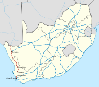
The N7 is a national route in South Africa that runs from Cape Town northwards through the West Coast and Namaqualand regions to the Namibian border at Vioolsdrif. It is known as the Cape Namibia Road. After crossing the border, it changes designation to B1 and runs north through Windhoek and the north of Namibia.

The Southern Line is a commuter rail line operated by Metrorail Western Cape, connecting Cape Town station in central Cape Town, South Africa with the Southern Suburbs and the towns on the west coast of False Bay, terminating in Simon's Town.
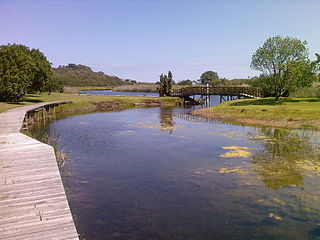
Wilderness National Park, also called the Wilderness Section, is located around the seaside town of Wilderness between the larger towns of George and Knysna, in the Western Cape. It is a protected area of South Africa forming part of the Garden Route National Park.

The Cairo–Cape Town Highway is Trans-African Highway 4 in the transcontinental road network being developed by the United Nations Economic Commission for Africa (UNECA), the African Development Bank (AfDB), and the African Union. The route has a length of 10,228 km (6,355 mi) and links Cairo in Egypt to Cape Town in South Africa.
Metropolitan Routes in Johannesburg, also called Metro Roads or Metro Routes are designated with the letter M, and are usually major routes around Johannesburg and some areas declared part of Greater Johannesburg.

In South Africa some roads are designated as numbered routes to help with navigation. There is a nationwide numbering scheme consisting of national, provincial and regional routes, and within various urban areas there are schemes of metropolitan route numbering.
The City of Cape Town like most South African metropolitan areas, uses Metropolitan or "M" routes for important intra-city routes, a layer below National (N) roads and Regional (R) roads. Each city's M roads are independently numbered.
