
Shau Kei Wan or Shaukiwan is a neighborhood in the Eastern District of Hong Kong Island. The area is bordered by Chai Wan to the east, Mount Parker to the south, Sai Wan Ho to the west, and Victoria Harbour to the north.

The N1 is a national route in South Africa that runs from Cape Town through Bloemfontein, Johannesburg, Pretoria and Polokwane to Beit Bridge on the border with Zimbabwe. It forms the first section of the famed Cape to Cairo Road.
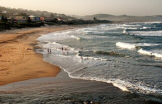
Scottburgh is a coastal resort town located on the south coast of KwaZulu-Natal, South Africa. It situated south of the mouth of the Mpambanyoni River (confuser of birds).

Ramsgate is a village on the south coast of KwaZulu-Natal in South Africa, just southwest of Margate. Ramsgate is located on the mouth of a river known by the Zulu name Bilanhlolo for the bubbles caused by strong currents making it look like the water is boiling. In 1922, there was only one person living there, Paul Buck, a painter and violin maker and he called the place Blue Lagoon.
Uvongo is a seaside resort in the KwaZulu-Natal South Coast at the mouth of the Vungu River in KwaZulu-Natal, South Africa. Uvongo is the largest upmarket residential area on the lower South Coast. The Vungu River has a waterfall that flows into a small gorge near the mouth. The town is named after the Vungu River, which is derived from the Zulu word that describes the sound of a waterfall or the wind in a gorge.

The Great Kei River is a river in the Eastern Cape province of South Africa. It is formed by the confluence of the Black Kei River and White Kei River, northeast of Cathcart. It flows for 320 km (199 mi) and ends in the Great Kei Estuary at the Indian Ocean with the small town Kei Mouth on the west bank. Historically the Great Kei River formed the southwestern border of the Transkei region as was formerly known as the Nciba River.

The R63 is a tarred provincial route in South Africa that connects Calvinia with Komga via Carnarvon, Victoria West, Graaff-Reinet, Somerset East and King William's Town. It is cosigned with the N10 between Eastpoort and Cookhouse for 24 kilometres.

The R102 is a Regional Route in South Africa. It is the route designation for all old sections of the N2, thus it is a discontinuous road that resumes in areas where a new N2 has been constructed.

The N2 is a national route in South Africa that runs from Cape Town through George, Gqeberha, East London, Mthatha, Port Shepstone and Durban to Ermelo. It is the main highway along the Indian Ocean coast of the country. Its current length of 2,255 kilometres (1,401 mi) makes it the longest numbered route in South Africa.

The Tsitsikamma National Park is a protected area on the Garden Route, Western Cape and Eastern Cape, South Africa. It is a coastal reserve well known for its indigenous forests, dramatic coastline, and the Otter Trail. On 6 March 2009 it was amalgamated with the Wilderness National Park and various other areas of land to form the Garden Route National Park.

The N6 is a national route in South Africa that connects East London with Bloemfontein, via Komani and Maletswai. It runs roughly from north to south, connecting the N1 with the N2.

The Wild Coast is a section of the coast of the Eastern Cape, a province of South Africa. The region stretches from East London in the south to the border of KwaZulu-Natal in the north. It is the traditional home of the Mpondo people, and the birthplace of many prominent South Africans, including Nelson Mandela and Thabo Mbeki.
Kei Mouth is a resort town on the southeast coast of South Africa, situated in the Wild Coast region of the Eastern Cape Province, situated 94 kilometres from the city of East London. The town is situated on the Indian Ocean coast, on the western bank of the Great Kei River, and has one of the country's three remaining car transporting pontoon river ferries.

Herolds Bay is a settlement in Garden Route District Municipality in the Western Cape province of South Africa.
Richtersveld is an administrative area in the Namakwa District of Northern Cape in South Africa.
Coffee Bay is a town on the Wild Coast of the Eastern Cape Province of South Africa. It is located about 250 kilometres south-west of the city of Durban and has a population of 258 people.
Athlone Park is a small coastal suburb located between Durban and Amanzimtoti in KwaZulu-Natal, South Africa.
The Cape Morgan Nature Reserve, part of the greater East London Coast Nature Reserve, is a coastal forest reserve in the Wild Coast region of the Eastern Cape. On its western side lies the Morgan Bay estuary, while it is flanked on the eastern side by the Cwili estuary. Nearby are the of villages of Morgan Bay and Kei Mouth. Southwest of the reserve is the Morgan Bay beach. Its shoreline is encompassed by the Kei section of the Amathole Marine Protected Area.
