
The N1 is a national route in South Africa that runs from Cape Town through Bloemfontein, Johannesburg, Pretoria and Polokwane to Beit Bridge on the border with Zimbabwe. It forms the first section of the famed Cape to Cairo Road.
The R58 is a provincial route in South Africa that connects Colesberg with Ngcobo via Aliwal North, Barkly East and Khowa.

The R61 is a long provincial route in South Africa that connects Beaufort West with Port Shepstone via Graaff-Reinet, Komani, Mthatha and Port Edward.

The R63 is a tarred provincial route in South Africa that connects Calvinia with Komga via Carnarvon, Victoria West, Graaff-Reinet, Somerset East and King William's Town. It is cosigned with the N10 between Eastpoort and Cookhouse for 24 kilometres.
The R67 is a provincial route in Eastern Cape, South Africa that connects Port Alfred with Komani via Grahamstown.

The R72 is a provincial route in Eastern Cape, South Africa that connects the N2 north-east of Gqeberha with East London via Port Alfred. It provides an alternative to the N2 for travel between Gqeberha and East London.
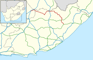
The R345 is a Regional Route in South Africa that connects Cathcart with Hamburg via Hogsback, Alice and the Double Drift Nature Reserve. It is co-signed with the R63 between Fort Hare and Alice.
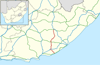
The R346 is a Regional Route in Eastern Cape, South Africa that connects Kidd's Beach with Stutterheim via King William’s Town.
The R397 is a Regional Route in South Africa that connects Burgersdorp with Molteno and Sterkstroom. Its northern terminus is the R391 near Burgersdorp. It heads south to meet the R56. It becomes cosigned, heading east-south-east, through Molteno. East of Molteno, it leaves the R56, heading south-east, via the Boesmanshoek pass, to Sterkstroom, where it meets and is briefly cosigned with the R344. Its southern is the N6.

Hogsback is a village in the Amathole Mountains in the Eastern Cape Province, South Africa.

Cathcart is a town in the Eastern Cape province of South Africa, named after Sir George Cathcart, governor of the Colony of the Cape of Good Hope 1852–1853. The town is situated on the N6, 48 kilometres (30 mi) north of Stutterheim en route to Komani. And it is the Biltong capital of South Africa.

The N6 is a national route in South Africa that connects East London with Bloemfontein, via Komani and Maletswai. It runs roughly from north to south, connecting the N1 with the N2.
Mpofu Nature Reserve is a nature reserve in the Amatole district of the Eastern Cape Province, South Africa that is managed by Eastern Cape Parks.
Katberg Pass is a mountain pass situated in the Eastern Cape province of South Africa, on the R351 between Seymour and Whittlesea. The pass climbs almost 700 meters in altitude to summit at 1622m ASL. The average gradient is 1:15 with some sections as steep as 1:3.
Nico Malan Pass is situated in the Eastern Cape province of South Africa, on the regional tarred road R67 between Fort Beaufort and Whittlesea.
Kitchingnathus is an extinct genus of basal procolophonid parareptile from Early Triassic deposits of Eastern Cape Province, South Africa. It is known from the holotype BP/1/1187, skull and partial postcranium, which was first assigned to the more derived Procolophon trigoniceps. It was collected by the South African palaeontologist, James W. Kitching in October 1952 from Hobbs Hill, west of Cathcart. It was found in the middle or upper part of the Katberg Formation of the Beaufort Group and referred to the uppermost Lystrosaurus Assemblage Zone. It was first named by Juan Carlos Cisneros in 2008 and the type species is Kitchingnathus untabeni. The generic name honours James W. Kitching, and "gnathus", from Greek gnathos meaning mandible. The specific name meaning "from the hill", in isiZulu, is in reference to the locality where the fossil was found.
The R701 is a major regional route in the Free State, South Africa.
The R717 is a Regional Route in South Africa that connects Colesberg with Dewetsdorp via Trompsburg, Edenburg and Reddersburg. From Colesberg to Reddersburg, it follows the older route of the N1.

The Katberg Formation is a geological formation that is found in the Beaufort Group, a major geological group that forms part of the greater Karoo Supergroup in South Africa. The Katberg Formation is the lowermost geological formation of the Tarkastad Subgroup which contains the Lower to Middle Triassic-aged rocks of the Beaufort Group. Outcrops and exposures of the Katberg Formation are found east of 24 degrees on wards and north of Graaff-Reniet, Nieu Bethesda, Cradock, Fort Beaufort, Queensdown, and East London in the south, and ranges as far north as Harrismith in deposits that form a ring around the Drakensberg mountain ranges.
