Hennenman is a town in the Free State goldfields in the Lejweleputswa District Municipality of the Free State province of South Africa. The settlement is unusual for the district as being supported by agriculture rather than the mining industry which is common in other towns.

The R26 is a provincial route in Free State, South Africa that connects Rouxville with Villiers via Zastron, Wepener, Ladybrand, Ficksburg, Bethlehem & Reitz.

The R30 is a provincial route in South Africa that connects Bloemfontein with Rustenburg via Brandfort, Welkom, Bothaville, Klerksdorp and Ventersdorp. The southern part of the route is tolled, as the R30 forms the first section of the ZR Mahabane Toll Route, with the Brandfort Toll Plaza found 10 kilometres north of its Southern junction with the N1 National Route. The tolled portion ends at the junction with the R730.

The R34 is a long provincial route in South Africa that connects Vryburg with Richards Bay via Kroonstad and Newcastle. It passes through three provinces, North West, the Free State and KwaZulu-Natal.

The R36 is a provincial route in South Africa that connects the N1 with Ermelo, via Tzaneen and Lydenburg. It is co-signed with the N4 for 8 kilometres between Machadodorp and Patattanek, with a tollgate on this section. It used to extend further south past Ermelo to Amersfoort, but that section is now designated as part of the N11.

The R37 is a provincial route in South Africa that connects Polokwane with Nelspruit (Mbombela) via Burgersfort and Lydenburg.

The R54 is a provincial route in South Africa that connects Potchefstroom with Villiers via Vereeniging.

The R56 is a provincial route in South Africa that connects Middelburg with Pietermaritzburg via Molteno, Maclear and Kokstad. It is co-signed with the N2 between Kokstad and Stafford's Post for 39 kilometres.

The R57 is a provincial route in South Africa that connects Vanderbijlpark with Phuthaditjhaba via Sasolburg, Heilbron and Reitz.

The R71 is a provincial route in Limpopo, South Africa that connects Polokwane with the Kruger National Park via Tzaneen and Phalaborwa.

The R73 is a provincial route in Free State, South Africa that connects Welkom with Winburg via Virginia.

The R76 is a provincial route in Free State, South Africa that connects Orkney with Bethlehem via Kroonstad.

The Province of the Orange Free State, commonly referred to as the Orange Free State, Free State or by its abbreviation OFS, was one of the four provinces of South Africa from 1910 to 1994. After 27 April 1994 it was dissolved following the first non-racial election in South Africa. It is now called the Free State Province.

The N4 is a national route in South Africa that runs from Skilpadshek on the Botswana border, past Rustenburg, Pretoria, eMalahleni and Mbombela, to Komatipoort on the Mozambique border. It forms the South African section of the Trans-Kalahari Corridor, which runs from Walvis Bay to Maputo, meaning that it links the east and west coasts of Southern Africa.

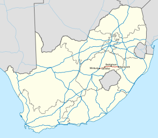
The N5 is a national route in South Africa that connects the N1 at Winburg with the N3 at Harrismith, via Senekal, Paul Roux and Bethlehem.

Matjhabeng Municipality is a local municipality within the Lejweleputswa District Municipality, in the Free State province of South Africa. The municipality includes Welkom, Virginia, Odendaalsrus and Allanridge. Matjhabeng is a Sesotho word meaning "where nations meet". It is derived from the migrant labour system where people from various countries like Lesotho, Mozambique, etc. met to work in the mines.
The R707 is a Regional Route in Free State, South Africa that connects Frankfort with Marquard via Petrus Steyn, Lindley, Arlington and Senekal.
The R708 is a Regional Route in South Africa that connects Jan Kempdorp in the Northern Cape with Clocolan in the Free State via Christiana, Hertzogville, Bultfontein, Theunissen, Winburg and Marquard.
The R730 is a Regional Route in Free State, South Africa. The entire 40-kilometre route is part of the ZR Mahabane Toll Route maintained by the South African National Roads Agency, which goes from Bloemfontein to Kroonstad. Although there are no tollgates on this stretch at the moment, it is labelled as a toll road to the near public and to motorists using the road.


